


Wednesday, 1 April 2009 - Monthly Climate Summary for Northern Territory - Product code IDCKGC22R0
Northern Territory in March 2009
Mostly Hot and Sunny
Jump to: Extremes Maps Records Summaries Notes the top
Summary
Whole of Territory averages …
- Maximum Temperature: 35.7°C, which was 1.8°C above the long-term average.
- Minimum Temperature: 22.0°C, which was 0.3°C above the long-term average.
- Rainfall: 21.9 mm, which was 79.9 mm below the long-term average, and the lowest value since 1991.
During March tropical cyclones formed over the oceans either side of the Australian continent, but as far as the Territory was concerned, the monsoon trough stayed offshore throughout the month. As a consequence, less rain than average was recorded across virtually the whole of the Territory, with more sunny days than usual and hotter day time temperatures.
Darwin
Darwin experienced its 4th driest March on record and driest since 1987, with only 115.6 mm being recorded at the Airport site, compared to the long-term average of 324.7 mm. The lack of rain meant more warm sunny days than usual, and Darwin recorded its 3rd hottest mean maximum temperature, at 33.2°C. The most recent hotter March was in 2002, when the average maximum temperature was 33.3°C. For the wet season rainfall to the end of March, Darwin has recorded 1519.8 mm, close to the long-term average of 1560.3 mm.Rainfall
Rainfall was less than average virtually throughout the Territory. Much of the southern half received no rain at all, while the lack of monsoon activity in the north led to much below average falls there.
Over the Territory as a whole, the area-averaged rainfall was 21.9 mm, 79.9 mm below the long-term average, and the lowest value since 1991.
The wettest overall was 299.0 mm at Pirlangimpi, followed by 288.6 mm at Ngayawili, followed by 268.8 mm at McCluer Island.
Some sites had their lowest total March rainfall on record.
Some sites had their lowest total March rainfall for at least 20 years.
The wettest single day 73.0 mm at Ngayawili on the 14th, followed by 72.0 mm at Mango Farm on the 1st, followed by 69.8 mm at Pirlangimpi on the 4th.
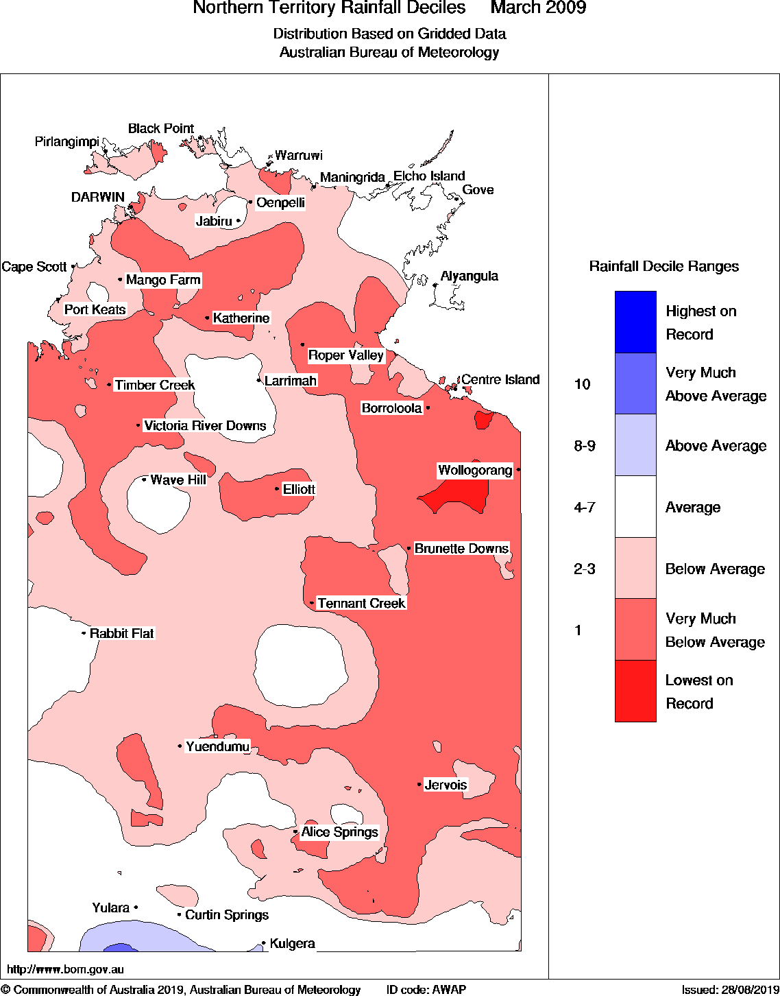
There is a map of rainfall deciles below.
Maximum temperature
Dry sunny conditions led to above average maximum temperatures this month. In the southern half, temperatures were 1−4°C above average, while in the northern half 0−2°C above average was the norm.
The area-averaged maximum temperature was 35.7°C, which was 1.8°C warmer than the long-term average.
The hottest day was 42.5°C at Walungurru on the 23rd, followed by 42.2°C at Walungurru on the 14th, followed by 42.2°C at Rabbit Flat on the 23rd, followed by 42.1°C at Jervois on the 3rd.
The warmest days on average were 39.3°C at Rabbit Flat, followed by 38.9°C at Walungurru, followed by 38.1°C at Lajamanu.
The coolest days on average were 31.2°C at McCluer Island, followed by 31.7°C at Gove Airport, followed by 31.8°C at Cape Don.
The coldest day was 23.5°C at Kulgera on the 4th, followed by 25.0°C at Curtin Springs on the 4th, followed by 25.0°C at Yulara Aero on the 4th.
Some sites had their highest March temperature on record.
Some sites had their highest March mean daily maximum temperature on record.
There is a map of mean maximum temperatures below. There is a map of maximum temperature anomalies below.Minimum temperature
Despite the lack of rain, some hot days and windy nights led to extremely warm overnight minimum temperatures in southern parts of the Territory. Alice Springs recorded its hottest March night on record on the 3rd, after equally the previous record on the first. Further north, where windy nights were less of a feature, the drier conditions generally led to cooler nights for most locations except for the northwest Top End.
The area-averaged minimum temperature was 22.0°C, which was 0.3°C above the long-term average.
The coldest night was 12.0°C at Kulgera on the 5th, followed by 12.4°C at Arltunga on the 6th, followed by 12.5°C at Kulgera on the 7th, followed by 12.5°C at Alice Springs Airport on the 18th.
The coolest nights on average were 19.2°C at Curtin Springs, followed by 19.3°C at Kulgera, followed by 19.4°C at Daly Waters AWS, followed by 19.4°C at Yulara Aero.
The warmest nights on average were 27.1°C at Centre Island, followed by 26.5°C at Cape Don.
The warmest night was 29.6°C at Alice Springs Airport on the 3rd, followed by 29.4°C at Alice Springs Airport on the 1st and 29.4°C at Jervois on the 14th.
Some sites had their warmest March night (highest daily minimum temperature) on record.
Some sites had their lowest March mean daily minimum temperature on record.
Wind
The strongest wind gust was 100 km/h at Darwin Airport on the 17th, followed by 76 km/h at Tennant Creek Airport on the 22nd, followed by 76 km/h at Alice Springs Airport on the 25th.
Other Reports
An archive of previous monthly summaries for Northern Territory is also available, as are summaries for other states and many other climate summaries and diagnostics.
Extremes
| Hottest day Highest temperature |
42.5°C at Walungurru on the 23rd 42.2°C at Walungurru on the 14th 42.2°C at Rabbit Flat on the 23rd |
|---|---|
| Warmest days on average Highest mean daily maximum temperature |
39.3°C at Rabbit Flat 38.9°C at Walungurru 38.1°C at Lajamanu |
| Coolest days on average Lowest mean daily maximum temperature |
31.2°C at McCluer Island 31.7°C at Gove Airport 31.8°C at Cape Don |
| Coldest day Lowest daily maximum temperature |
23.5°C at Kulgera on the 4th 25.0°C at Curtin Springs on the 4th 25.0°C at Yulara Aero on the 4th |
| Coldest night Lowest temperature |
12.0°C at Kulgera on the 5th 12.4°C at Arltunga on the 6th 12.5°C at Kulgera on the 7th 12.5°C at Alice Springs Airport on the 18th |
| Coolest nights on average Lowest mean daily minimum temperature |
19.2°C at Curtin Springs 19.3°C at Kulgera 19.4°C at Daly Waters AWS 19.4°C at Yulara Aero |
| Warmest nights on average Highest mean daily minimum temperature |
27.8°C at Northern Endeavour 27.1°C at Centre Island 26.5°C at Cape Don |
| Warmest night Highest daily minimum temperature | 29.6°C at Alice Springs Airport on the 3rd 29.4°C at Alice Springs Airport on the 1st 29.4°C at Jervois on the 14th |
| Wettest overall Highest total rainfall |
299.0 mm at Pirlangimpi 288.6 mm at Ngayawili 268.8 mm at McCluer Island |
| Wettest day Highest daily rainfall |
73.0 mm at Ngayawili on the 14th 72.0 mm at Mango Farm on the 1st 69.8 mm at Pirlangimpi on the 4th |
| Highest wind gust |
100 km/h at Darwin Airport on the 17th 76 km/h at Tennant Creek Airport on the 22nd 76 km/h at Alice Springs Airport on the 25th |
Jump to: Extremes Maps Records Summaries Notes the top
Maps
Rainfall deciles
Jump to: Extremes Maps Records Summaries Notes the top
Records
| Record lowest total March rainfall | |||||
|---|---|---|---|---|---|
|
Total rainfall for March 2009 (mm) |
Previous lowest for March |
Years of record |
Average for March |
||
| Berrimah Research Farm | 66.2 | 72.4 | in 1978 | 43 | 352.9 |
| Centre Island | 5.6 | 10.0 | in 1987 | 40 | 266.9 |
| McArthur River Mine | 5.4 | 13.4 | in 1987 | 37 | 142.4 |
| Lowest total March rainfall for at least 20 years | |||||
|---|---|---|---|---|---|
|
Total rainfall for March 2009 (mm) |
Most recent lower for March |
Years since lower |
Average for March |
||
| Victoria River Downs | 0.2 | 0.0 | in 1946 | 60 | 109.9 |
| Old Delamere | 5.2 | 0.0 | in 1938 | 24 | 137.8 |
| Darwin Airport | 115.6 | 93.0 | in 1987 | 22 | 324.7 |
| Elliott | 1.0 | 0.0 | in 1987 | 22 | 90.5 |
| Howard Springs | 85.5 | 64.6 | in 1987 | 22 | 381.2 |
| Kidman Springs | 14.0 | 11.0 | in 1987 | 20 | 134.3 |
| Waterloo | 4.2 | 0.0 | in 1987 | 20 | 105.2 |
| Record highest March temperature | ||||||
|---|---|---|---|---|---|---|
|
Highest temperature in March 2009 (°C) |
Previous highest for March |
Years of record |
Average for March |
|||
| Pirlangimpi | 35.2 | on the 21st | 35.0 | on the 30th in 1998 | 25 | 31.8 |
| Record highest March mean daily maximum temperature | |||||
|---|---|---|---|---|---|
|
Mean daily maximum temperature for March 2009 (°C) |
Previous highest for March |
Years of record |
Average for March |
||
| Yuendumu | 37.2 | 37.0 | in 1992 | 40 | 33.3 |
| Mango Farm | 35.4 | = 35.4 | in 2002 | 27 | 33.9 |
| Timber Creek | 37.5 | = 37.5 | in 1990 | 27 | 35.4 |
| Pirlangimpi | 32.9 | 32.7 | in 1992 | 25 | 31.8 |
| Record highest March daily minimum temperature | ||||||
|---|---|---|---|---|---|---|
|
Highest daily minimum temperature in March 2009 (°C) |
Previous highest for March |
Years of record |
Average for March |
|||
| Alice Springs Airport | 29.6 | on the 3rd | 29.4 | on the 4th in 1951 | 66 | 17.5 |
| Jervois | 29.4 | on the 14th | 29.2 | on the 17th in 2004 | 39 | 19.2 |
| Record lowest March mean daily minimum temperature | |||||
|---|---|---|---|---|---|
|
Mean daily minimum temperature for March 2009 (°C) |
Previous lowest for March |
Years of record |
Average for March |
||
| Larrimah | 19.9 | 20.5 | in 1997 | 42 | 22.6 |
| Daly Waters AWS | 19.4 | 20.6 | in 1946 | 38 | 22.6 |
| Katherine Aviation Museum | 21.1 | 21.5 | in 1997 | 21 | 23.2 |
| Tindal RAAF | 21.0 | 21.1 | in 1997 | 20 | 23.1 |
Jump to: Extremes Maps Records Summaries Notes the top
Summaries
| Summary statistics for March 2009 | ||||||||||||
|---|---|---|---|---|---|---|---|---|---|---|---|---|
| Maximum temperatures for March (°C) |
Minimum temperatures for March (°C) |
Rainfall for March (millimetres) |
||||||||||
| Mean for March 2009 |
Diff from average |
Highest for March 2009 |
Mean for March 2009 |
Diff from average |
Lowest for March 2009 |
Total for March 2009 |
Average for March |
Rank of March 2009 |
Fraction of March average |
|||
| Darwin-Daly (district 14GA) | ||||||||||||
| Batchelor Aero | 34.1 | +1.3 | 36.3 | 22nd | 22.3 | −1.1 | 16.0 | 19th | 50.4 | 250.8 | low | 20% |
| Black Point | 32.0 | +0.6 | 35.1 | 19th | 26.0 | +0.5 | 22.3 | 30th | 154.4 | 249.5 | average | 62% |
| Bradshaw | 37.6 | 39.5 | 22nd | 23.1 | 19.0 | 19th | 17.0 | |||||
| Cape Don | 31.8 | 33.7 | 19th | 26.5 | 22.6 | 30th | 68.4 | 235.1 | very low | 29% | ||
| Central Arnhem Plateau | 34.1 | 35.8 | 23rd | 22.4 | 19.4 | 19th | 26.0 | |||||
| Channel Point | 32.9 | +1.2 | 34.4 | 6th | 24.9 | +0.5 | 22.4 | 20th | 109.4 | 390.3 | very low | 28% |
| Darwin Airport | 33.2 | +1.3 | 34.9 | 18th | 24.8 | +0.3 | 22.2 | 19th | 115.6 | 324.7 | very low | 36% |
| Delamere Weapons Range | 35.5 | +1.2 | 37.7 | 22nd | 21.6 | −1.6 | 17.0 | 19th | 10.2 | 196.1 | low | 5% |
| Douglas River | 35.0 | +1.4 | 36.6 | 30th | 21.6 | −1.5 | 17.1 | 19th | 81.0 | 230.4 | very low | 35% |
| Dum In Mirrie AWS | 32.6 | 34.6 | 18th | 25.7 | 20.8 | 18th | 191.6 | 364.4 | low | 53% | ||
| Jabiru Airport | 35.4 | +1.9 | 37.1 | 23rd | 24.5 | +0.2 | 22.1 | 20th | 209.8 | 323.1 | average | 65% |
| Katherine Aviation Museum | 35.3 | +1.0 | 38.0 | 23rd | 21.1 | −2.1 | 16.5 | 19th | 10.0 | 207.9 | very low | 5% |
| Mango Farm | 35.4 | +1.6 | 37.0 | 24th | 22.8 | −0.8 | 17.6 | 19th | 148.8 | 215.6 | average | 69% |
| McCluer Island | 31.2 | 33.1 | 19th | 26.2 | 22.7 | 30th | 268.8 | 229.9 | average | 117% | ||
| Middle Point AWS | 34.6 | 36.9 | 22nd | 23.2 | 18.9 | 19th | 228.8 | |||||
| Noonamah AWS | 34.5 | 36.4 | 22nd | 23.2 | 17.9 | 19th | 165.4 | |||||
| Pine Creek Council | 34.8 | 36.3 | 23rd | 22.8 | 19.5 | 19th | 67.8 | |||||
| Pirlangimpi | 32.9 | +1.1 | 35.2 | 21st | 24.0 | 0.0 | 20.8 | 18th | 299.0 | 372.2 | average | 80% |
| Port Keats Aero | 34.8 | 37.2 | 24th | 23.5 | 21.2 | 29th | 96.8 | |||||
| Tindal RAAF | 35.4 | +1.3 | 36.9 | 23rd | 21.0 | −2.1 | 16.0 | 19th | 6.4 | 176.7 | very low | 4% |
| Arnhem (district 14BC) | ||||||||||||
| Alyangula Police | 32.3 | +0.2 | 33.8 | 6th | 23.7 | −0.9 | 21.8 | 27th | 191.0 | 257.4 | average | 74% |
| Gove Airport | 31.7 | +0.5 | 33.5 | 7th | 23.7 | −0.2 | 21.5 | 29th | 185.2 | 268.8 | average | 69% |
| Groote Eylandt Airport AWS | 33.2 | 34.9 | 9th | 22.1 | 19.4 | 20th | 268.2 | |||||
| Maningrida Aero | 32.8 | 36.2 | 22nd | 24.4 | 21.9 | 19th | 138.2 | |||||
| Milingimbi AWS | 33.5 | 36.3 | 22nd | 24.8 | 22.4 | 19th | 85.2 | |||||
| Ngayawili | 32.2 | 33.7 | 6th | 24.2 | 21.8 | 19th | 288.6 | |||||
| Warruwi | 32.3 | +0.9 | 34.7 | 20th | 25.3 | +0.2 | 23.3 | 14th | 77.0 | 240.5 | very low | 32% |
| Roper-Mcarthur (district 14DE) | ||||||||||||
| Borroloola | 35.0 | +1.6 | 37.2 | 22nd | 21.4 | −2.1 | 17.5 | 8th | 34.4 | 156.6 | low | 22% |
| Bulman AWS | 35.2 | 36.7 | 22nd | 21.2 | 17.5 | 31st | 64.2 | |||||
| Centre Island | 34.6 | +1.7 | 36.7 | 19th | 27.1 | +0.7 | 25.7 | 8th | 5.6 | 266.9 | lowest | 2% |
| Daly Waters AWS | 35.4 | +0.8 | 37.1 | 23rd | 19.4 | −3.2 | 14.3 | 18th | 64.0 | 110.4 | average | 58% |
| Larrimah | 35.0 | +0.9 | 37.0 | 23rd | 19.9 | −2.7 | 15.5 | 8th | 47.4 | 155.7 | low | 30% |
| McArthur River Mine | 37.3 | +2.4 | 39.2 | 21st | 22.6 | −0.7 | 17.7 | 8th | 5.4 | 142.4 | lowest | 4% |
| Ngukurr | 35.9 | +1.8 | 38.3 | 22nd | 23.4 | −0.5 | 21.0 | 10th | 34.8 | 172.1 | low | 20% |
| Wollogorang | 35.8 | +1.3 | 37.5 | 22nd | 20.9 | −1.9 | 16.1 | 8th | 5.5 | 167.0 | very low | 3% |
| Victoria (district 14F) | ||||||||||||
| Kidman Springs | 36.8 | +1.3 | 39.1 | 23rd | 21.6 | −1.8 | 16.4 | 20th | 14.0 | 134.3 | very low | 10% |
| Lajamanu | 38.1 | +3.6 | 41.1 | 23rd | 21.0 | −1.1 | 14.9 | 19th | 0 | 81.3 | lowest | 0% |
| Timber Creek | 37.5 | +2.1 | 39.5 | 24th | 21.3 | −2.3 | 16.0 | 20th | 20.8 | 172.5 | very low | 12% |
| Victoria River Downs | 36.8 | +1.7 | 38.5 | 23rd | 21.5 | −1.7 | 16.1 | 20th | 0.2 | 109.9 | very low | 0% |
| Wave Hill | 36.8 | +1.3 | 39.0 | 23rd | 20.4 | −1.8 | 14.4 | 20th | 46.1 | 121.5 | average | 38% |
| Barkly (district 15A) | ||||||||||||
| Elliott | 35.5 | −0.2 | 38.1 | 22nd | 20.6 | −1.6 | 16.0 | 20th | 1.0 | 90.5 | very low | 1% |
| Tennant Creek Airport | 36.2 | +1.9 | 39.0 | 23rd | 23.0 | −0.2 | 19.4 | 19th | 0 | 57.0 | lowest | 0% |
| Alice Springs (district 15B) | ||||||||||||
| Alice Springs Airport | 35.3 | +2.6 | 40.6 | 3rd | 19.7 | +2.2 | 12.5 | 18th | 0.4 | 31.9 | low | 1% |
| Arltunga | 34.5 | 40.2 | 3rd | 19.6 | 12.4 | 6th | 5.0 | 38.8 | average | 13% | ||
| Curtin Springs | 36.0 | +2.3 | 41.2 | 23rd | 19.2 | +0.8 | 14.0 | 5th | 4.2 | 28.9 | average | 15% |
| Jervois | 36.9 | +2.2 | 42.1 | 3rd | 20.8 | +1.6 | 14.3 | 19th | 0 | 30.6 | lowest | 0% |
| Kulgera | 34.0 | +1.8 | 42.0 | 2nd | 19.3 | +1.3 | 12.0 | 5th | 20.2 | 32.7 | average | 62% |
| Papunya | 37.8 | 41.3 | 3rd | 21.2 | 15.1 | 18th | 0 | 49.3 | lowest | 0% | ||
| Rabbit Flat | 39.3 | +3.5 | 42.2 | 23rd | 21.2 | −0.4 | 14.3 | 18th | 10.0 | 75.1 | low | 13% |
| Territory Grape Farm | 36.7 | +2.4 | 40.8 | 3rd | 20.5 | +0.9 | 15.0 | 17th | 0 | 19.4 | lowest | 0% |
| Walungurru | 38.9 | 42.5 | 23rd | 24.7 | 20.4 | 8th | 8.6 | |||||
| Watarrka | 36.3 | +1.7 | 40.6 | 22nd | 21.1 | +0.4 | 14.5 | 7th | 2.1 | 29.4 | average | 7% |
| Yuendumu | 37.2 | +3.9 | 39.8 | 3rd | 21.2 | +1.5 | 15.0 | 18th | 2.0 | 46.1 | average | 4% |
| Yulara Aero | 35.5 | +1.0 | 40.7 | 23rd | 19.4 | +0.3 | 14.0 | 5th | 8.6 | 33.4 | average | 26% |
Jump to: Extremes Maps Records Summaries Notes the top
Notes
This statement has been prepared based on information available at 12 pm on Wednesday 1 April 2009. Some checks have been made on the data, but it is possible that results will change as new information becomes available.
Averages are long-term means based on observations from
the years 1800 to 2007.
They are not shown for sites with less than 10 years of record in that time, as they cannot then be calculated reliably.
The median
is sometimes more representative than the
mean
of long-term average rain.
The Rank indicates how rainfall this time compares with the climate record for the site,
based on the
decile ranking
(very low rainfall is in decile 1, low in decile 2 or 3,
average in decile 4 to 7, high in decile 8 or 9
and very high is in decile 10).
The Fraction of average shows how much rain has fallen this time as a
percentage of the long-term mean.
Further information
NT Climate Services CentreBureau of Meteorology
Phone (08) 8920 3813
Email climate.nt@bom.gov.au