


Monday, 2 August 2010 - Monthly Climate Summary for Western Australia - Product code IDCKGC21R0
Western Australia in July 2010: Wet in the north but dry in the west
- Above average rainfall for WA, but below average for the southwest
- Near average mean maximum temperature for WA
- Above average mean minimum temperature for WA, but well below average for the southwest
Details Extremes Maps Records Summaries Important notes the top
Rainfall
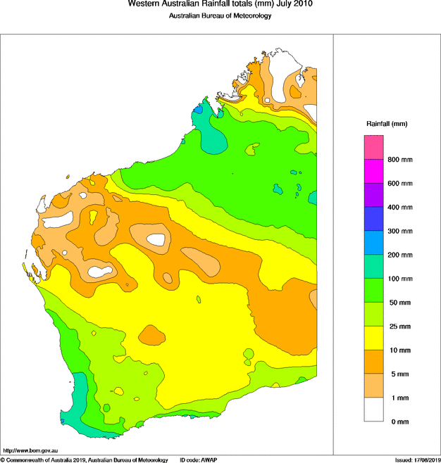
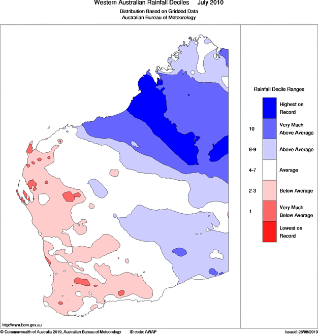
In July 2010, most of the Kimberley, adjacent parts of the Pilbara, Interior, Goldfields and Eucla registered above to very much above average rainfall. During the first two weeks of July, rainfall occurred in these regions, with some heavy daily falls above 50 mm. In the Kimberley, a number of sites registered their highest daily rainfall on record for July. Derby Main Roads reported 108.6 mm in the 24 hours to 9 am on the 10th, the highest daily rainfall in WA for July 2010. Consequently, several sites in the Kimberley, including Broome Airport, recorded their wettest July on record.
In contrast, western parts of WA, from the western Pilbara, the Gascoyne, and Southwest Land Division (SWLD) saw mostly below to very much below average rainfall in July. A strong cold front brought the first significant rainfall of the month to most of the southern half of the state on the 8th, with daily totals generally ranging from 20 mm to 50 mm in western parts of the SWLD in the 24 hours to 9 am on the 9th, and a few sites in the northern SWLD and southern Gascoyne registered their highest daily rainfall on record for July. Two additional cold fronts and a slow moving low brought more rainfall later in the month to the southern half of the state, however dry spells in the first and third week of the month in much of the SWLD resulted in a generally below average month for western parts of the state, and several sites in the SWLD recorded their lowest July rainfall on record.
The wet conditions in the north and dry conditions in the west culminated in the state mean for July 2010 being near average (see July rainfall totals & decile maps).
Maximum temperature
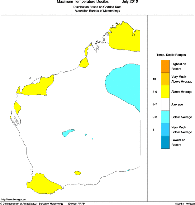
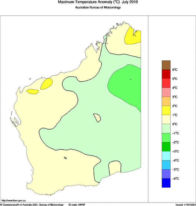
Close to normal mean maximum temperatures were reported across most of WA during July. Above average mean maximum temperatures were mainly confined to the north and west Kimberley, the west Pilbara, and west coast parts of WA. Areas of the west Pilbara and north and west Kimberley saw mean maxima up to 2 °C above normal. Conversely, parts of the northeast Interior were below average, with up to 3 °C below normal mean maxima. When averaged over the whole state, July 2010 was near average(see July maximum temperature decile & anomaly maps).
A lack of cool air from the south caused daytime and overnight temperatures in the northern half of the state to be well above average in the last few days of July. A number of sites in the Pilbara recorded their highest daytime temperature on record.
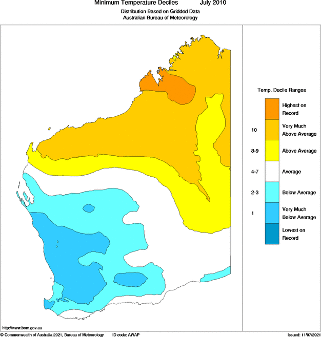
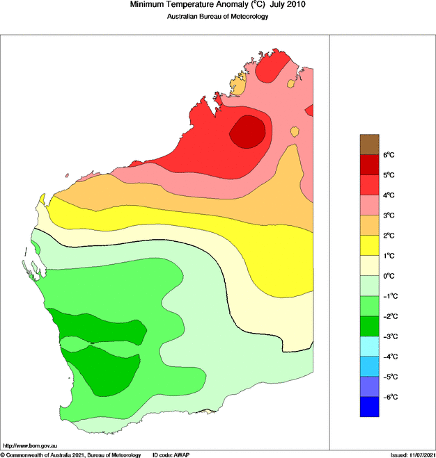
Minimum temperature
Above to very much above average mean minimum temperatures were recorded in the the northern half of the state in July, with mean minima in the central Kimberley up to 6 °C above average. A few sites in the Kimberley and east Pilbara, including Broome Airport, recorded their hottest July in terms of overnight minimum temperatures. Some unusually warm nights for July were recorded in the Pilbara in the last week of the month and a few sites recorded their hottest July night on record.
A large area in the southern half of the state saw below to very much below average mean minima in July, with up to 3 °C below normal mean minima in the Central West and neighbouring districts. Clear conditions early in the month in southern parts saw a run of cold nights continue from June. Several sites in the SWLD recorded their lowest July temperatures on record on the 3rd and 4th, whilst a minimum temperature of -0.4 °C at Geraldton Airport on the 4th was its first ever sub-zero temperature in its 68 years of record. As a result of this and other clear dry spells during the month, several sites in the SWLD, and Eyre in the Eucla, experienced their coldest July on record in terms of mean minimum temperature.
When averaged over the whole state, July 2010 was above average for mean minimum temperature due to the conditions in the north, despite southwest WA (southwest of a line from Jurien to Bremer Bay) being well below average (see July minimum temperature decile & anomaly maps).
Further information
- Media
- media@bom.gov.au (03) 9669 4057
- Enquiries
- helpdesk.climate@bom.gov.au
| Extremes in July 2010 | |
|---|---|
| Hottest day | 37.3 °C at Wyndham Aero on the 31st |
| Warmest days on average | 32.8 °C at Wyndham Aero |
| Coolest days on average | 14.5 °C at Rocky Gully |
| Coldest day | 9.2 °C at Rocky Gully on the 12th |
| Coldest night | -5.2 °C at Eyre on the 5th |
| Coolest nights on average | 1.5 °C at York |
| Warmest nights on average | 24.3 °C at Troughton Island |
| Warmest night | 25.7 °C at Troughton Island on the 25th |
| Wettest overall | 227.2 mm at Witchcliffe |
| Wettest day | 108.6 mm at Derby Main Roads on the 10th |
| Highest wind gust | 113 km/h at North Island on the 9th |
Details Extremes Records Summaries Important notes the top
| Record highest July daily rainfall | ||||||
|---|---|---|---|---|---|---|
| Highest daily rainfall in July 2010 (mm) |
Previous highest for July |
Years of record |
||||
| Yeeda | 65.0 | on the 6th | 64.8 | on the 14th in 1956 | 108 | |
| Trayning | 34.0 | on the 9th | 31.8 | on the 5th in 1963 | 96 | |
| Paynes Find | 30.8 | on the 9th | 29.0 | on the 10th in 2009 | 49 | |
| Badgingarra Research Stn | 60.8 | on the 9th | 60.2 | on the 4th in 1985 | 47 | |
| Rawlinna Homestead | 16.4 | on the 9th | 14.8 | on the 4th in 1997 | 47 | |
| Country Downs | 74.4 | on the 6th | 56.0 | on the 7th in 1978 | 39 | |
| Dampier Downs | 77.0 | on the 10th | 62.4 | on the 6th in 1978 | 36 | |
| Nita Downs | 41.0 | on the 5th | 35.6 | on the 7th in 1978 | 31 | |
| Record highest total July rainfall | |||||
|---|---|---|---|---|---|
|
Total rainfall for July 2010 (mm) |
Previous highest for July |
Years of record |
Average for July |
||
| Broome Airport | 106.8 | 101.4 | in 2001 | 70 | 7.3 |
| Balgo Hills | 75.6 | 66.9 | in 1957 | 63 | 8.8 |
| Derby Aero | 153.0 | 80.0 | in 1978 | 56 | 7.9 |
| Country Downs | 142.2 | 65.6 | in 1978 | 39 | 8.2 |
| Dampier Downs | 141.2 | 69.0 | in 1978 | 36 | 8.2 |
| Nita Downs | 97.0 | 44.6 | in 1978 | 31 | 6.8 |
| Record lowest total July rainfall | |||||
|---|---|---|---|---|---|
| Total rainfall for July 2010 (mm) |
Previous lowest for July |
Years of record |
Average for July |
||
| Gingin | 39.0 | 40.9 | in 1937 | 120 | 147.9 |
| Codg Codgen | 3.8 | 8.1 | in 1957 | 108 | 50.0 |
| Rushy Pool | 7.0 | 13.8 | in 1957 | 99 | 67.8 |
| Doodlakine | 4.0 | 8.4 | in 2005 | 98 | 47.0 |
| Cuballing | 15.4 | 26.4 | in 1998 | 97 | 89.7 |
| Bolgart | 9.4 | 23.5 | in 1957 | 94 | 86.7 |
| Bungulla | 1.2 | 7.7 | in 2005 | 82 | 48.6 |
| Warra Jarra | 22.8 | 26.4 | in 1994 | 32 | 58.0 |
| Record highest July temperature | ||||||
|---|---|---|---|---|---|---|
| Highest temperature in July 2010 (°C) |
Previous highest for July |
Years of record |
Average for July |
|||
| Roebourne | 34.8 | on the 27th | 33.9 | on the 7th in 2009 | 53 | 26.7 |
| Mandora | 35.8 | on the 27th | 35.7 | on the 31st in 1992 | 49 | 28.9 |
| Record lowest July daily maximum temperature | ||||||
|---|---|---|---|---|---|---|
|
Lowest daily maximum temperature in July 2010 (°C) |
Previous lowest for July |
Years of record |
Average for July |
|||
| Badgingarra Research Stn | 11.4 | on the 9th | 11.7 | on the 29th in 1975 | 44 | 17.6 |
| Telfer Aero | 13.1 | on the 5th | 13.6 | on the 9th in 1986 | 37 | 25.3 |
| Record highest July daily minimum temperature | ||||||
|---|---|---|---|---|---|---|
|
Highest daily minimum temperature in July 2010 (°C) |
Previous highest for July |
Years of record |
Average for July |
|||
| Port Hedland Airport | 22.7 | on the 30th | 22.4 | on the 16th in 1996 | 63 | 12.3 |
| Wittenoom | 20.9 | on the 28th | 20.6 | on the 12th in 1995 | 58 | 11.5 |
| Telfer Aero | 21.5 | on the 29th | 20.9 | on the 31st in 2007 | 37 | 10.5 |
| Record lowest July temperature | ||||||
|---|---|---|---|---|---|---|
|
Lowest temperature in July 2010 (°C) |
Previous lowest for July |
Years of record |
Average for July |
|||
| Geraldton Airport | -0.4 | on the 4th | 0.8 | on the 27th in 1990 | 68 | 9.5 |
| Perth Airport | -1.0 | on the 3rd | -0.8 | on the 22nd in 2006 | 67 | 8.1 |
| Pearce RAAF | -1.9 | on the 4th | -1.0 | on the 22nd in 2006 | 53 | 8.5 |
| Badgingarra Research Stn | 1.3 | on the 4th | 1.7 | on the 21st in 1987 | 43 | 7.3 |
| Narembeen | -3.2 | on the 3rd | -2.5 | on the 2nd in 1982 | 40 | 5.5 |
| Pingelly | -2.5 | on the 3rd | -1.6 | on the 12th in 2005 | 39 | 5.6 |
| Record highest July mean daily minimum temperature | |||||
|---|---|---|---|---|---|
| Mean daily minimum temperature for July 2010 (°C) |
Previous highest for July |
Years of record |
Average for July |
||
| Broome Airport | 18.2 | 17.6 | in 1973 | 70 | 13.6 |
| Bidyadanga | 17.8 | 17.4 | in 1973 | 51 | 13.8 |
| Warmun | 17.4 | 16.9 | in 1998 | 48 | 12.5 |
| Telfer Aero | 13.3 | 12.7 | in 1975 | 36 | 10.5 |
| Record lowest July mean daily minimum temperature | |||||
|---|---|---|---|---|---|
| Mean daily minimum temperature for July 2010 (°C) |
Previous lowest for July |
Years of record |
Average for July |
||
| Lake Grace Comparison | 3.6 | 3.7 | in 1969 | 54 | 5.6 |
| Eyre | 2.5 | 3.5 | in 2005 | 52 | 5.9 |
| Pearce RAAF | 5.5 | 6.5 | in 1997 | 49 | 8.5 |
| Merredin | 3.4 | 3.8 | in 1989 | 44 | 5.6 |
| Wongan Hills | 4.8 | 4.9 | in 1997 | 43 | 6.6 |
| Badgingarra Research Stn | 5.5 | 5.8 | in 1986 | 42 | 7.3 |
| Brookton | 2.1 | 2.5 | in 1997 | 42 | 4.6 |
| Jurien Bay | 7.0 | 7.5 | in 2006 | 40 | 9.5 |
| Pingelly | 3.2 | 4.0 | in 1997 | 38 | 5.6 |
| Eneabba | 6.9 | 7.2 | in 2006 | 36 | 9.1 |
Details Extremes Records Summaries Important notes the top
| Summary statistics for July 2010 | ||||||||||||
|---|---|---|---|---|---|---|---|---|---|---|---|---|
| Maximum temperatures for July (°C) |
Minimum temperatures for July (°C) |
Rainfall for July (millimetres) |
||||||||||
| Mean for July 2010 |
Diff from average |
Highest for July 2010 |
Mean for July 2010 |
Diff from average |
Lowest for July 2010 |
Total for July 2010 |
Average for July |
Rank of July 2010 |
Fraction of July average |
|||
| North Kimberley (district 01) | ||||||||||||
| Kalumburu | 32.2 | +0.2 | 35.3 | 31st | 18.8 | +5.5 | 12.7 | 18th | 0 | 0.4 | v low | 0% |
| Kuri Bay | 31.0 | -0.1 | 34.7 | 26th | 16.0 | 23rd | 3.4 | 4.8 | high | 71% | ||
| Mount Elizabeth | 29.1 | +0.6 | 33.5 | 30th | 12.7 | +4.8 | 5.4 | 23rd | 7.2 | 3.3 | high | 218% |
| Troughton Island | 29.5 | +1.4 | 30.9 | 26th | 24.3 | +2.2 | 22.0 | 2nd | 0.4 | 3.0 | high | 13% |
| Truscott | 31.1 | 33.4 | 27th | 21.5 | 18.1 | 17th | 0 | |||||
| Wyndham | 32.3 | +1.1 | 36.6 | 31st | 20.1 | +3.2 | 15.2 | 22nd | 0 | 3.3 | lowest | 0% |
| Wyndham Aero | 32.8 | 37.3 | 31st | 19.7 | 14.0 | 22nd | 0 | 3.3 | v low | 0% | ||
| East Kimberley (district 02) | ||||||||||||
| Argyle Aerodrome | 30.2 | +0.5 | 35.2 | 30th | 18.5 | +3.0 | 13.4 | 22nd | 1.4 | 1.5 | high | 93% |
| Halls Creek Airport | 26.5 | -0.7 | 32.8 | 29th | 15.6 | +3.1 | 10.1 | 2nd | 64.0 | 6.2 | v high | 1032% |
| Kununurra Aero | 31.1 | +0.6 | 35.6 | 28th | 18.5 | +3.4 | 14.3 | 22nd | 1.4 | 1.7 | high | 82% |
| Warmun | 36.0 | 30th | 17.4 | +4.9 | 12.5 | 22nd | 2.2 | 5.5 | high | 40% | ||
| West Kimberley (district 03) | ||||||||||||
| Bidyadanga | 30.2 | +0.8 | 35.5 | 27th | 17.8 | +4.0 | 14.6 | 2nd | 80.8 | 8.5 | v high | 951% |
| Broome Airport | 28.9 | +0.1 | 33.2 | 25th | 18.2 | +4.6 | 14.9 | 2nd | 106.8 | 7.3 | highest | 1463% |
| Curtin Aero | 30.2 | -0.8 | 35.8 | 27th | 18.8 | +3.6 | 13.8 | 2nd | 110.2 | 8.9 | v high | 1238% |
| Derby Aero | 29.9 | -0.8 | 34.5 | 27th | 18.3 | +3.6 | 14.6 | 2nd | 153.0 | 7.9 | highest | 1937% |
| Fitzroy Crossing Aero | 30.0 | -0.9 | 35.0 | 29th | 16.6 | +4.8 | 10.7 | 23rd | 67.8 | 7.7 | v high | 881% |
| West Roebuck | 30.3 | -0.6 | 35.0 | 27th | 17.1 | +5.1 | 13.0 | 24th | 119.8 | 23.2 | high | 516% |
| De Grey (district 04) | ||||||||||||
| Bedout Island | 25.3 | 28.0 | 29th | 20.2 | 16.0 | 5th | ||||||
| Karratha Aero | 26.9 | +0.7 | 32.4 | 27th | 16.4 | +2.8 | 10.6 | 11th | 5.0 | 14.8 | average | 34% |
| Legendre Island | 24.9 | 31.0 | 17th | 18.8 | 15.0 | 5th | ||||||
| Mandora | 28.8 | -0.1 | 35.8 | 27th | 16.8 | +4.4 | 11.0 | 24th | 73.6 | 9.0 | v high | 818% |
| Marble Bar | 26.3 | 33.6 | 27th | 14.8 | 10.3 | 11th | 57.8 | 22.9 | high | 252% | ||
| Pardoo Station | 28.2 | +0.3 | 34.4 | 28th | 16.8 | +4.0 | 12.0 | 2nd | 46.3 | 9.8 | v high | 472% |
| Port Hedland Airport | 27.6 | +0.5 | 34.1 | 28th | 16.1 | +3.8 | 11.7 | 2nd | 53.2 | 11.2 | v high | 475% |
| Roebourne | 28.5 | +1.8 | 34.8 | 27th | 16.2 | +2.6 | 11.1 | 10th | 8.1 | 13.9 | average | 58% |
| Roebourne Aero | 28.2 | 34.7 | 28th | 15.5 | 9.4 | 11th | 5.4 | 11.8 | high | 46% | ||
| Fortescue (district 05) | ||||||||||||
| Barrow Island Airport | 23.7 | -0.1 | 25.7 | 31st | 18.4 | +0.8 | 14.7 | 14th | 9.0 | 13.2 | average | 68% |
| Learmonth Airport | 24.6 | +0.4 | 28.0 | 27th | 11.8 | +0.4 | 6.1 | 25th | 0 | 22.7 | lowest | 0% |
| Mardie | 28.3 | +0.6 | 32.5 | 27th | 14.3 | +2.6 | 8.4 | 11th | 2.2 | 13.3 | average | 17% |
| Onslow | 26.7 | +1.9 | 31.6 | 27th | 14.9 | +3.2 | 10.6 | 11th | 0 | 18.5 | lowest | 0% |
| Onslow Airport | 26.9 | +1.7 | 30.6 | 27th | 14.5 | +1.7 | 10.3 | 11th | 0.6 | 19.6 | v low | 3% |
| Tom Price | 22.8 | -0.2 | 29.3 | 28th | 8.6 | +1.5 | 4.0 | 15th | 3.6 | 16.8 | average | 21% |
| Wittenoom | 24.7 | +0.5 | 31.4 | 28th | 13.2 | +1.7 | 6.3 | 14th | 11.0 | 14.3 | average | 77% |
| West Gascoyne (district 06) | ||||||||||||
| Carnarvon Airport | 22.9 | +0.6 | 27.6 | 22nd | 9.2 | -1.8 | 4.5 | 2nd | 5.6 | 45.6 | low | 12% |
| Emu Creek Station | 25.7 | +0.3 | 30.5 | 16th | 12.3 | +1.1 | 7.5 | 10th | 1.0 | 22.2 | low | 5% |
| Gascoyne Junction | 23.1 | +0.1 | 27.7 | 16th | 8.9 | -0.4 | 3.7 | 7th | 0.7 | 27.5 | low | 3% |
| Shark Bay Airport | 22.5 | -0.3 | 26.2 | 22nd | 9.4 | -1.2 | 2.8 | 7th | 2.8 | 29.0 | v low | 10% |
| East Gascoyne (district 07) | ||||||||||||
| Newman Aero | 22.7 | -0.3 | 31.4 | 27th | 7.7 | +1.8 | 0.9 | 2nd | 5.0 | 14.9 | average | 34% |
| Paraburdoo Aero | 24.5 | -0.3 | 30.7 | 16th | 10.9 | +1.3 | 4.5 | 25th | 4.2 | 14.9 | average | 28% |
| Murchison (district 07A) | ||||||||||||
| Meekatharra Airport | 18.9 | -0.1 | 24.8 | 16th | 6.0 | -1.4 | 2.4 | 2nd | 5.0 | 21.7 | low | 23% |
| Mount Magnet Aero | 18.0 | -0.7 | 23.7 | 16th | 5.4 | -1.6 | 1.3 | 1st | 16.2 | 30.7 | average | 53% |
| North Coast (district 08) | ||||||||||||
| Carnamah | 18.1 | +0.2 | 21.5 | 7th | 5.5 | -1.8 | 0.2 | 5th | 48.5 | 68.1 | average | 71% |
| Dalwallinu | 16.8 | -0.1 | 21.3 | 25th | 4.2 | -1.7 | -0.2 | 4th | 43.2 | 47.1 | average | 92% |
| Dalwallinu Comparison | 17.2 | +0.2 | 21.6 | 25th | 4.6 | -2.0 | 0.5 | 2nd | 44.7 | 60.0 | low | 75% |
| Eneabba | 23.1 | 25th | 6.9 | -2.2 | 1.1 | 5th | 83.2 | 95.3 | average | 87% | ||
| Geraldton Airport | 19.3 | -0.2 | 23.1 | 7th | 6.8 | -2.7 | -0.4 | 4th | 81.6 | 92.5 | average | 88% |
| Kalbarri | 21.7 | 0.0 | 25.5 | 7th | 7.9 | -1.8 | 1.8 | 2nd | 40.8 | 72.2 | low | 57% |
| Morawa Airport | 18.4 | -0.2 | 23.0 | 25th | 3.6 | -2.6 | -0.7 | 4th | 37.0 | 44.9 | average | 82% |
| Mullewa | 19.2 | +0.5 | 23.6 | 25th | 5.9 | -1.1 | 1.9 | 2nd | 37.3 | 60.4 | low | 62% |
| North Island | 20.8 | 23.8 | 8th | 14.9 | 11.0 | 9th | 39.8 | |||||
| Wongan Hills | 17.2 | +0.2 | 22.0 | 25th | 4.8 | -1.8 | -0.7 | 6th | 50.8 | 69.7 | average | 73% |
| Central Coast (district 09) | ||||||||||||
| Badgingarra Research Stn | 17.1 | -0.5 | 21.0 | 25th | 5.5 | -1.8 | 1.3 | 4th | 88.2 | 106.3 | average | 83% |
| Bickley | 15.0 | 0.0 | 19.8 | 25th | 6.7 | -0.4 | 3.0 | 3rd | 175.6 | 220.7 | low | 80% |
| Champion Lakes | 17.4 | 21.8 | 25th | 7.7 | 2.7 | 4th | 111.6 | |||||
| Garden Island HSF | 17.4 | 19.8 | 25th | 10.1 | 6.2 | 5th | 84.2 | |||||
| Gingin Aero | 18.0 | -0.3 | 23.1 | 25th | 3.2 | -3.2 | -3.7 | 5th | 96.2 | 127.7 | low | 75% |
| Gooseberry Hill | 16.2 | -0.2 | 21.2 | 25th | 8.6 | -0.6 | 5.5 | 3rd | ||||
| Gosnells City | 18.5 | -0.1 | 23.6 | 25th | 6.6 | -2.3 | 1.1 | 4th | 140.7 | 165.1 | low | 85% |
| Jandakot Aero | 18.1 | +0.3 | 22.3 | 25th | 4.3 | -2.6 | -1.9 | 3rd | 106.8 | 178.2 | low | 60% |
| Jurien Bay | 19.7 | +0.3 | 22.8 | 15th | 7.0 | -2.5 | 1.6 | 5th | 67.6 | 114.4 | low | 59% |
| Karnet | 15.4 | 0.0 | 20.0 | 25th | 4.7 | -1.6 | 0.5 | 5th | 156.2 | 222.4 | low | 70% |
| Lancelin | 19.4 | +0.3 | 22.7 | 16th | 4.0 | 6th | 55.0 | 122.9 | v low | 45% | ||
| Medina Research Centre | 18.4 | +0.2 | 22.0 | 25th | 6.4 | -2.0 | 0.2 | 3rd | 123.0 | 151.2 | average | 81% |
| Pearce RAAF | 17.9 | +0.1 | 22.5 | 25th | 5.5 | -3.0 | -1.9 | 4th | 112.4 | 137.3 | low | 82% |
| Perth Airport | 18.4 | +0.5 | 23.1 | 25th | 5.8 | -2.3 | -1.0 | 3rd | 133.2 | 158.9 | low | 84% |
| Perth Metro | 18.2 | -0.1 | 22.7 | 25th | 5.9 | -2.1 | 0.0 | 3rd | 142.0 | 170.0 | average | 83% |
| Rottnest Island | 17.3 | -0.4 | 19.7 | 25th | 11.7 | -0.6 | 7.9 | 10th | 88.2 | 113.4 | average | 78% |
| Swanbourne | 18.2 | -0.1 | 21.0 | 25th | 8.3 | -1.4 | 4.0 | 5th | 148.0 | 151.3 | average | 98% |
| South Coast (district 09A) | ||||||||||||
| Albany | 16.6 | +0.9 | 20.8 | 25th | 8.3 | +0.2 | 5.6 | 13th | 159.0 | 144.0 | average | 110% |
| Albany Airport | 16.0 | +0.2 | 19.8 | 25th | 6.6 | -0.9 | 2.2 | 24th | 133.8 | 120.7 | average | 111% |
| Bridgetown | 15.8 | +0.1 | 19.2 | 25th | 3.1 | -1.3 | -1.0 | 24th | 88.4 | 123.1 | low | 72% |
| Bridgetown Comparison | 16.6 | +0.8 | 20.8 | 25th | 3.0 | -1.4 | -1.0 | 25th | 89.5 | 146.8 | v low | 61% |
| Bunbury | 17.3 | +0.1 | 19.8 | 25th | 5.3 | -1.9 | -0.3 | 3rd | 135.0 | 150.2 | average | 90% |
| Busselton | 16.9 | -0.2 | 19.4 | 15th | 6.9 | -1.2 | 1.5 | 3rd | ||||
| Busselton Aero | 16.5 | -0.2 | 19.2 | 23rd | 5.2 | -1.7 | 0.0 | 3rd | 138.6 | 138.3 | average | 100% |
| Cape Leeuwin | 16.9 | +0.6 | 19.9 | 23rd | 11.6 | +0.3 | 9.1 | 21st | 141.6 | 182.4 | low | 78% |
| Cape Naturaliste | 16.9 | +0.6 | 20.3 | 25th | 10.2 | -0.2 | 6.4 | 3rd | 120.8 | 162.7 | low | 74% |
| Collie East | 16.8 | 20.5 | 25th | 2.3 | -2.1 | 3rd | 111.2 | |||||
| Donnybrook | 17.2 | +0.7 | 21.0 | 25th | 4.6 | -1.1 | 0.0 | 3rd | 141.1 | 187.5 | low | 75% |
| Dwellingup | 15.5 | +0.5 | 19.2 | 25th | 3.5 | -2.0 | -1.6 | 3rd | 177.8 | 240.1 | low | 74% |
| Esperance | 17.4 | +0.3 | 22.9 | 26th | 7.7 | -0.6 | 5.0 | 3rd | 97.6 | 96.8 | average | 101% |
| Esperance Aero | 15.8 | -0.5 | 20.6 | 26th | 7.0 | -0.6 | 3.5 | 3rd | 67.6 | 79.4 | average | 85% |
| Harvey | 16.8 | 19.5 | 25th | 6.0 | 2.0 | 3rd | 167.2 | 158.6 | average | 105% | ||
| Hopetoun North | 17.7 | -0.5 | 23.8 | 26th | 7.2 | -0.5 | 3.5 | 8th | 51.8 | 65.3 | average | 79% |
| Jarrahwood | 16.5 | +0.2 | 19.9 | 25th | 3.5 | -1.4 | -1.5 | 21st | 128.1 | 178.3 | low | 72% |
| Mandurah | 17.1 | 19.9 | 23rd | 9.4 | 5.4 | 5th | 121.2 | |||||
| Manjimup | 15.0 | +0.7 | 19.1 | 25th | 5.8 | -0.6 | 2.0 | 3rd | 120.8 | 175.6 | low | 69% |
| North Walpole | 16.0 | 19.8 | 25th | 8.4 | 4.5 | 3rd | 165.2 | |||||
| Pemberton | 15.8 | +0.8 | 19.5 | 25th | 6.9 | -0.3 | 3.0 | 3rd | 155.6 | 211.4 | low | 74% |
| Rocky Gully | 14.5 | -0.2 | 18.9 | 25th | 5.8 | -0.7 | 1.8 | 3rd | 92.0 | 95.9 | average | 96% |
| Shannon | 14.8 | -0.1 | 19.0 | 25th | 6.2 | -0.2 | 2.4 | 3rd | 140.8 | 163.9 | average | 86% |
| Windy Harbour | 17.1 | +0.4 | 20.2 | 25th | 9.0 | +0.4 | 5.0 | 1st | 162.4 | 191.3 | average | 85% |
| Witchcliffe | 16.5 | +0.1 | 19.9 | 25th | 7.0 | -1.2 | 1.6 | 21st | 227.2 | 186.9 | high | 122% |
| North Central (district 10) | ||||||||||||
| Bencubbin | 16.7 | +0.3 | 21.2 | 25th | 4.9 | -1.1 | -0.4 | 1st | 23.4 | 45.5 | low | 51% |
| Cunderdin Airfield | 16.9 | 0.0 | 21.7 | 25th | 2.4 | -2.3 | -3.7 | 5th | 40.8 | 51.1 | average | 80% |
| Merredin | 16.3 | +0.1 | 21.2 | 25th | 3.4 | -2.2 | -2.5 | 4th | 51.0 | 51.0 | average | 100% |
| Northam | 17.1 | +0.2 | 21.4 | 25th | 2.7 | -2.7 | -3.1 | 7th | 68.0 | 82.8 | average | 82% |
| York | 17.0 | +0.1 | 21.0 | 25th | 1.5 | -2.3 | -4.2 | 7th | 60.3 | 72.0 | average | 84% |
| South Central (district 10A) | ||||||||||||
| Beverley | 16.9 | +0.1 | 20.6 | 25th | 2.6 | -2.6 | -2.4 | 3rd | 51.4 | 77.8 | low | 66% |
| Brookton | 15.7 | -0.4 | 19.5 | 25th | 2.1 | -2.5 | -2.7 | 3rd | 47.5 | 85.4 | low | 56% |
| Corrigin | 15.5 | +0.2 | 20.4 | 25th | 2.3 | -2.6 | -2.9 | 7th | 30.4 | 59.6 | low | 51% |
| Hyden | 16.9 | +0.6 | 22.0 | 25th | 2.6 | -2.1 | -4.0 | 3rd | 34.5 | 47.7 | average | 72% |
| Jacup | 15.8 | +0.2 | 19.9 | 8th | 4.5 | -1.1 | 0.9 | 3rd | 34.4 | 50.5 | low | 68% |
| Katanning | 14.7 | 0.0 | 18.7 | 25th | 5.0 | -1.0 | 1.4 | 21st | 43.0 | 66.5 | v low | 65% |
| Katanning Comparison | 15.3 | +0.7 | 19.4 | 25th | 4.2 | -1.2 | -1.0 | 23rd | 51.4 | 75.7 | low | 68% |
| Lake Grace | 15.3 | -0.3 | 19.5 | 25th | 3.2 | -2.1 | -1.0 | 3rd | 32.6 | 37.4 | average | 87% |
| Lake Grace Comparison | 15.4 | 0.0 | 19.5 | 25th | 3.6 | -2.0 | -0.5 | 3rd | 27.8 | 47.5 | low | 59% |
| Narembeen | 16.2 | -0.3 | 21.0 | 25th | 3.6 | -1.9 | -3.2 | 3rd | 36.7 | 49.9 | average | 74% |
| Narrogin | 14.8 | +0.3 | 19.0 | 25th | 3.1 | -2.2 | -1.3 | 3rd | 52.2 | 87.7 | low | 60% |
| Newdegate Research Station | 15.0 | -0.2 | 19.8 | 8th | 2.9 | -1.2 | -1.0 | 6th | 0 | 47.9 | lowest | 0% |
| Ongerup | 15.3 | +0.4 | 18.8 | 25th | 4.3 | -1.5 | 0.1 | 5th | 55.6 | 49.9 | average | 111% |
| Pingelly | 15.5 | +0.2 | 19.4 | 25th | 3.2 | -2.4 | -2.5 | 3rd | 41.8 | 82.1 | low | 51% |
| Ravensthorpe | 16.0 | -0.3 | 20.2 | 26th | 5.9 | -0.8 | 2.1 | 3rd | 40.2 | 46.8 | average | 86% |
| Wagin | 15.5 | +0.2 | 19.0 | 25th | 3.7 | -1.9 | -0.4 | 24th | 47.2 | 71.4 | low | 66% |
| Wandering | 15.6 | -0.2 | 20.2 | 25th | 1.9 | -2.2 | -2.8 | 3rd | 77.8 | 97.8 | v low | 80% |
| Eucla (district 11) | ||||||||||||
| Balladonia | 17.5 | -0.1 | 22.5 | 27th | 4.1 | -0.7 | -0.6 | 6th | 19.7 | 20.3 | average | 97% |
| Eucla | 17.7 | -0.3 | 22.5 | 17th | 6.2 | -0.8 | 1.8 | 5th | 44.4 | 25.1 | high | 177% |
| Eyre | 18.5 | +0.4 | 22.3 | 16th | 2.5 | -3.4 | -5.2 | 5th | 26.9 | 34.4 | average | 78% |
| Forrest | 17.5 | -1.2 | 22.6 | 28th | 4.3 | -0.8 | 0.5 | 7th | 22.8 | 17.9 | average | 127% |
| Red Rocks Point | 17.5 | 21.6 | 16th | 6.2 | 2.6 | 11th | 39.4 | |||||
| South East (district 12) | ||||||||||||
| Bulga Downs | 19.3 | 25.2 | 16th | 3.7 | -1.7 | 2nd | 11.4 | 23.4 | average | 49% | ||
| Kalgoorlie-Boulder Airport | 16.8 | +0.1 | 21.9 | 16th | 4.6 | -0.4 | -0.4 | 4th | 12.6 | 24.8 | low | 51% |
| Laverton Aero | 17.3 | -1.1 | 23.3 | 26th | 4.9 | -1.0 | -0.3 | 4th | 24.4 | 17.1 | high | 143% |
| Leinster Aero | 17.7 | -1.0 | 24.0 | 16th | 4.7 | -1.5 | -0.5 | 2nd | 19.0 | 19.5 | average | 97% |
| Leonora | 17.9 | -0.6 | 23.8 | 16th | 5.1 | -1.0 | 0.9 | 2nd | 20.2 | 18.8 | average | 107% |
| Leonora Aero | 17.9 | 23.9 | 16th | 4.6 | -0.9 | 2nd | 17.6 | |||||
| Munglinup West | 16.1 | 22.7 | 26th | 5.9 | 2.0 | 3rd | 23.8 | |||||
| Norseman | 17.4 | +0.7 | 22.5 | 26th | 3.3 | -1.9 | -1.0 | 1st | 17.2 | 26.9 | average | 64% |
| Norseman Aero | 16.7 | -0.7 | 21.8 | 16th | 2.7 | -1.5 | -2.4 | 1st | 13.6 | 20.8 | average | 65% |
| Southern Cross Airfield | 16.3 | -0.3 | 21.6 | 26th | 2.0 | -1.3 | -3.3 | 4th | 26.2 | 35.7 | low | 73% |
| North East (district 13) | ||||||||||||
| Balgo Hills | 24.4 | -2.1 | 32.2 | 28th | 14.0 | +1.7 | 9.3 | 2nd | 75.6 | 8.8 | highest | 859% |
| Carnegie | 20.6 | -0.7 | 28.0 | 27th | 5.4 | -0.4 | -1.2 | 2nd | 3.5 | 11.8 | average | 30% |
| Giles Meteorological Office | 19.1 | -0.9 | 27.2 | 29th | 7.8 | +0.9 | 2.3 | 14th | 25.4 | 11.7 | high | 217% |
| Telfer Aero | 24.8 | -0.5 | 32.9 | 28th | 13.3 | +2.8 | 7.8 | 2nd | 66.4 | 13.5 | v high | 492% |
| Warburton Airfield | 19.9 | -0.8 | 28.0 | 28th | 6.8 | +1.1 | 0.1 | 14th | 14.4 | 13.1 | high | 110% |
| Wiluna | 18.9 | -0.5 | 25.2 | 27th | 3.8 | -1.6 | -0.5 | 2nd | 14.1 | 15.1 | average | 93% |
Details Extremes Records Summaries Important notes the top
Notes
A Monthly Climate Summary is prepared to list the main features of the weather in Western Australia using the most timely and accurate information available on the date of publication; it will generally not be updated. Later information, including data that has had greater opportunity for quality control, will be presented in the Monthly Weather Review, usually published in the fourth week of the month.
This statement has been prepared based on information available at 9 am on Monday 2 August 2010. Some checks have been made on the data, but it is possible that results will change as new information becomes available.
Averages are long-term means based on observations from all available
years of record, which vary widely from site to site. They are not shown for
sites with less than 10 years of record.
The median
is sometimes more representative than the
mean
of long-term average rain.
The Rank indicates how rainfall this time compares with the climate record for the site,
based on the
decile ranking
(very low rainfall is in decile 1, low in decile 2 or 3,
average in decile 4 to 7, high in decile 8 or 9
and very high is in decile 10).
The Fraction of average shows how much rain has fallen this time as a
percentage of the long-term mean.
Records in this summary are based on sites with at least 30 years of data.
For PDF files of Perth Metro climate statistics for other months, please click here for extremes and here for averages.
Further information
- Media
- media@bom.gov.au (03) 9669 4057
- Enquiries
- helpdesk.climate@bom.gov.au
![]() Unless otherwise noted, all maps, graphs and diagrams in this page are licensed under the Creative Commons Attribution 4.0 International Licence
Unless otherwise noted, all maps, graphs and diagrams in this page are licensed under the Creative Commons Attribution 4.0 International Licence
