


Tuesday, 1 December 2009 - Seasonal Climate Summary for Western Australia - Product code IDCKGC11R0
Western Australia in spring 2009: Warmer than normal Spring for WA
- Very much above average mean maximum temperature for WA
- Above average mean minimum temperature for WA
- Near average rainfall for WA
Details Extremes Records Important notes the top
Rainfall
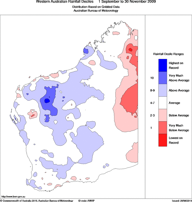
This spring, parts of the northwest and central WA saw above to very much above average rainfall, mainly the result of a wet November. The far eastern parts of WA experienced below to very much below average spring rainfall, due to a dry October and November (see spring 2009 rainfall decile map). For Western Australia as a whole, spring 2009 was near average.
Some sites had their highest total spring rainfall on record. Some sites had their highest spring daily rainfall on record.Maximum temperature
Apart from near average daytime temperatures along the western strip, most of WA saw above to very much above average mean maximum temperatures, with means up to 3°C above normal in parts of eastern WA. This was mainly the result of warmer than normal maxima in the Kimberley and most of the Interior in September, and above to very much above average maxima for most of WA in October. The statewide mean maximum temperature for spring was very much above average.
Some sites had their highest spring temperature on record.Minimum temperature
Mean minimum temperatures were above to very much above average in spring over much of the northern half of WA, as well as the adjacent Goldfields, Eucla and south of the Southwest Land Division, with means up to 2°C higher than normal in parts of northwest, and southeast WA. Overall, the statewide mean minimum temperature for spring was in the above average range.
Some sites had their warmest spring night (highest daily minimum temperature) on record.Further information
- Media
- media@bom.gov.au (03) 9669 4057
- Enquiries
- helpdesk.climate@bom.gov.au
| Extremes in spring 2009 | |
|---|---|
| Hottest day | 45.6 °C at Mandora on 29 Oct |
| Warmest days on average | 40.0 °C at Fitzroy Crossing Aero |
| Coolest days on average | 18.4 °C at Shannon |
| Coldest day | 9.8 °C at Rocky Gully on 5 Sep |
| Coldest night | -4.3 °C at Eyre on 9 Sep |
| Coolest nights on average | 7.4 °C at Wandering |
| Warmest nights on average | 27.0 °C at Troughton
Island 25.0 °C at Wyndham (mainland) |
| Warmest night | 31.4 °C at Wittenoom on 30 Oct |
| Wettest overall | 394.1 mm at Pemberton |
| Wettest day | 104.0 mm at Kilto Station on 6 Nov |
| Highest wind gust | 120 km/h at Esperance on 6 Nov |
Details Extremes Records Important notes the top
| Record highest spring daily rainfall | ||||||
|---|---|---|---|---|---|---|
| Highest daily rainfall in spring 2009 (mm) |
Previous highest for spring |
Years of record |
||||
| Broome Airport | 44.6 | on 6 Nov | 36.8 | on 10 Nov 1943 | 71 | |
| Record highest spring temperature | ||||||
|---|---|---|---|---|---|---|
|
Highest temperature in spring 2009 (°C) |
Previous highest for spring |
Years of record |
Average for spring |
|||
| Giles Meteorological Office | 43.9 | on 17 Nov | 43.8 | on 30 Nov 1996 | 54 | 31.1 |
| Eucla | 44.5 | on 13 Nov | 44.0 | on 23 Nov 1982 | 50 | 22.9 |
| Record highest spring daily minimum temperature | ||||||
|---|---|---|---|---|---|---|
|
Highest daily minimum temperature in spring 2009 (°C) |
Previous highest for spring |
Years of record |
Average for spring |
|||
| Kalgoorlie-Boulder Airport | 25.7 | on 28 Oct | 25.6 | on 23 Nov 1980 | 69 | 11.0 |
| Corrigin | 24.7 | on 12 Nov | 23.7 | on 23 Nov 1977 | 62 | 8.4 |
| Hyden | 24.8 | on 12 Nov | 23.0 | on 23 Nov 1977 | 38 | 8.4 |
Details Extremes Records Important notes the top
Notes
This statement has been prepared based on information available at 12 pm on Tuesday 1 December 2009. Some checks have been made on the data, but it is possible that results will change as new information becomes available.
Averages are long-term means based on observations from
all available years of record, which vary widely from site to site.
They are not shown for sites with less than 30 years of record, as they cannot then be calculated reliably.
The median
is sometimes more representative than the
mean
of long-term average rain.
Further information
- Media
- media@bom.gov.au (03) 9669 4057
- Enquiries
- helpdesk.climate@bom.gov.au
![]() Unless otherwise noted, all maps, graphs and diagrams in this page are licensed under the Creative Commons Attribution 4.0 International Licence
Unless otherwise noted, all maps, graphs and diagrams in this page are licensed under the Creative Commons Attribution 4.0 International Licence
