


This brochure describes the flood risk and previous flooding in the
Tully River catchment, last updated in July 2025.
Flood Risk
The Tully River catchment covers an area of 1475 square kilometres. The Tully River is a relatively short river, rising in the coastal ranges on the North Tropical Coast, one of the wettest places in Australia, before flowing across the coastal plain. The Murray River has a significantly smaller catchment in comparison but still receives high rainfall. Like the Tully River, the lower reaches of the Murray River cross the coastal plain.
Floods in the Tully and Murray Rivers inundate cane lands and the larger floods isolate farmhouses. During significant major floods, the floodplains of the Tully and Murray Rivers may merge between Euramo and Murray Flats. An important impact of Tully River floods is the cutting of the Bruce Highway at Euramo.
Previous Flooding
Significant floods include 1967, 2009, 2018, December 2023, and February 2024.
In 2023, Tropical Cyclone Jasper crossed the North Queensland coast as a Category 2 system on Wednesday evening 13 December near Wujal Wujal, bringing widespread heavy rain. Tropical Cyclone Jasper transitioned to a tropical low after making landfall and then moved slowly west over Cape York Peninsula before becoming near stationary over the northern Gulf Country. Linked to ex-Tropical Cyclone Jasper, a coastal trough developed and brought further widespread heavy to locally intense rainfall across the North Queensland coast.
The Tully and Murray River catchments recorded rainfall totals of between 793 mm and 1144 mm for the period 12 to 17 December 2023, with rainfall totals most significant in the upper parts of the catchment. The heaviest day of rainfall was 16 December.
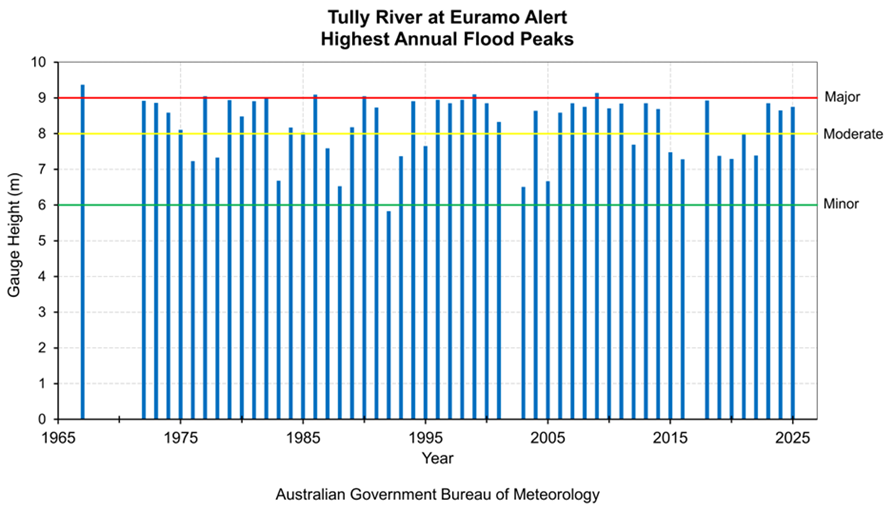
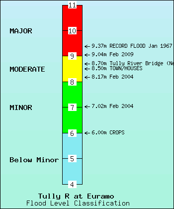
At Euramo, the Tully River peaked around 8.85 m at 11:15 am on 17 December 2023, below the major flood level of 9 m. The Tully River station at Euramo has a well-documented history of flooding with records dating back to 1972. The highest recorded flood peak is 9.37 m in January 1967, which was obtained by surveying a flood mark prior to the use of a gauge for this location. Note that the current official forecast location gauging station at Euramo opened in 2002 and data prior to 2002 on the graph below is sourced from comparable manual observations.
At Murray Flats, data was unavailable during the December 2023 event, though river levels were estimated to have reached the major flood level (8.0 m). The highest recorded flood peak is 8.80 m in March 2018.
More recently, in February 2024, flash flooding impacted the Tully area with 458 mm of rain recorded in 24 hours. This resulted in the inundation of businesses and clubs, and some vehicles were swept off the highway.
| Flood Event | Euramo | Murray Flats |
| Jan 1967 | 9.37 | - |
| Feb 1999 | 8.87 | - |
| Feb 2009 | 9.14 | 8.71 |
| Mar 2018 | 8.93 | 8.80 |
| Dec 2023 | 8.85 | - |
| Feb 2024 | 8.65 | - |
| Feb 2025 | 8.75 | - |
All heights are in metres on flood gauges.
Further Information:
- Latest rainfall and river heights
- For information on the flood warning service for the Tully and Murray River: Queensland Service Level Specification
- Catchment map: Johnstone, Tully, Murray, Herbert map
- National Arrangements for Flood Forecasting and Warning