South East Queensland: Water management
The authority for the administration of basic water rights and water entitlements (interim allocations, water licences, and water allocations) is governed by water resource plans prepared by the Department of Natural Resources and Mines. A water resource plan advances the sustainable management of water across the region. In addition, resource operations plans are used to implement outcomes and strategies specified in the water resource plan.

Surface water and groundwater management
Water legislation
Surface water
The Queensland Water Act 2000 (Water Act) authorises the administration of basic water rights and water entitlements (interim allocations, water licences and water allocations) in Queensland (Queensland Government Office of the Parliamentary Counsel 2015b). The Water Act is supported by the Queensland Government Office of the Parliamentary Counsel's Water Regulation 2002 (2016), which provides details on the procedures and fees associated with water access entitlements and trading.
Under s. 38 of the Water Act, the relevant minister may prepare a water resource plan for any part of Queensland to advance the sustainable management of water. Water resource plans may be prepared for, but are not limited to, the purposes listed under s. 38(3) of the Water Act.
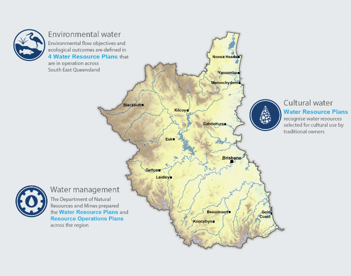
There are water resource plans in place to manage water across the entire South East Queensland region. Resource operations plans implement the outcomes and strategies specified in the water resource plan. The resource operations plan specifies the day-to-day rules and management arrangement for water users and infrastructure operators.
The Water Act vests all rights to the use, flow and control of water in the State of Queensland.
Water management plans
A number of water management instruments including water resource plans used in the region are described in Table R1.
| Water resource plan (WRP) | Resource operations plan (ROP) | Water Supply System (WSS) and Resource Operations Licence (ROL) / Interim Resource Operations Licence (IROL) |
| Gold Coast WRP 2006 (Queensland Government Office of the Parliamentary Counsel 2014b) | Gold Coast ROP (Queensland Government Department of Natural Resources and Mines 2016a) | Nerang WSS ROL |
| Logan Basin WRP 2007 (Queensland Government Office of the Parliamentary Counsel 2014c) | Logan Basin ROP (Queensland Government Department of Natural Resources and Mines 2016b) | Logan River WSS ROL |
| Moreton WRP 2007 (Queensland Government Office of the Parliamentary Counsel 2014a) | Moreton ROP (Queensland Government Department of Natural Resources and Mines 2016c) | Central Brisbane River and Stanley WSS ROL Cressbrook Creek WSS ROL Pine Valleys WSS ROL Central Lockyer WSS IROL1 Lower Lockyer WSS ROL Warrill Valley WSS ROL |
| Mary Basin WRP 2006 (Queensland Government Office of the Parliamentary Counsel 2014d) | Mary Basin ROP (Queensland Government Department of Natural Resources and Mines 2016d) | Baroon Pocket WSS ROL Mary Valley WSS ROL |
ROL is not administered under a ROP.
The South East Queensland region contains four water resource plan areas (Figure R8):
- Gold Coast
- Logan Basin
- Moreton
- part of Mary Basin.

Figure R8 Water resource plan areas in the South East Queensland region
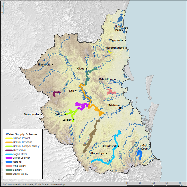
Within each water resource plan area, there is a number of water supply schemes as shown in Figure R9, made up of connected water supply infrastructure.

Figure R9 Water supply schemes in the South East Queensland region
A resource operations licence or interim resource operations licence (Queensland Government Department of Natural Resources and Mines 2016e) provide a licence under which water supply infrastructure can be operated.
Water resource plans
Water resource plans are used to:
- detail how the Queensland Government aims to meet each catchments' social, economic and environmental needs
- outline environmental flow objectives specific to plan area
- consider environmental values and water quality objectives
- describe water allocation security objectives.
Resource operations plans
The purpose of resource operations plans is to:
- specify information for each regional water supply scheme
- detail how to operationally meet each water resource plan's environmental flow objectives and water allocation security objectives
- describe how the water resources will be managed on a daily basis to meet these needs
- outline water supply scheme licence-holder flow management, infrastructure operating conditions, water sharing, monitoring and trading rules.
Resource operations licences
Resource operations licences are used to:
- provide detail of the licence holder and the resource operations plan to which the licence relates
- stipulate, if required, the water infrastructure such as dams and weirs, covered by the licence
- specify any conditions that the licence holder must comply with, including operating arrangements and water supply requirements.
Seqwater is the resource operations licence holder for all water supply schemes in the South East Queensland region, with the exception of the Cressbrook Creek Water Supply Scheme, which is held by Toowoomba Regional Council.
Interim resource operations licences
Interim resource operations licences are granted in relation to infrastructure in an area where a resource operations plan has not been approved or the infrastructure has not yet been included in a resource operations plan. The purpose of interim resource operations licences is to:
- provide detail about the licence holder
- stipulate, if required, the water infrastructure such as dams and weirs, covered by the licence
- specify any conditions that the licence holder must comply with, including operating arrangements and water supply requirements.
The water management plans and water supply schemes in the South East Queensland region during the 2015–16 year are detailed in Table R3. Areas not covered by the water supply scheme are managed as Queensland unsupplemented water rights (which, for national consistency, are referred to as 'unregulated water rights' in the 2016 Account) under the Water Act, water resource plans and resource operations plans. Queensland Government Department of Natural Resources and Mines (2016f) defined unallocated water as 'water in the consumptive pool not allocated to licence holders or needed for losses'. Unallocated water may be held as a general, strategic or town water supply reserve. Water in a water resource plan area, if any, is identified in the water resource plan and a process for dealing with unallocated water is included in the resource operations plan.
Groundwater management plans
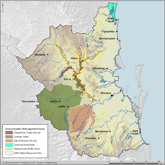
The following groundwater management areas (Figure R10) exist within the South East Queensland region (Queensland Government Office of the Queensland Parliamentary Counsel 2014a) and Queensland Government Office of the Queensland Parliamentary Counsel 2014d):
- Cressbrook Creek Alluvial
- Lockyer Valley
- Warrill Bremer Alluvial
- Watercourse Buffer Zone
- Cooloola Sandmass aquifer.
The first four aquifers are located within the Moreton Water Resource Plan area and the Cooloola sandmass aquifer is located in Mary Basin Water Resource Plan area. They have yet to be included in a resource operations plan. A model has been developed to estimate the groundwater asset in Implementation Area 1 of the Lockyer Valley Groundwater Management Area. Methods for calculating groundwater assets in the other groundwater management areas in the South East Queensland region are still under investigation.

Figure R10 The groundwater management areas in the South East Queensland region
Environmental water management
Environmental water legislation
The Water Act covers water for the environment. Water resource plans are produced in accordance with the Water Act and must establish environmental flow objectives and ecological outcomes as well as consider environmental values listed in the Environmental Protection (Water) Policy 2009 (Queensland Government Office of the Parliamentary Counsel 2014e).
Environmental water provisions
The environmental flow objectives in a water resource plan area are met through rules governing storage releases and limiting abstractions. Their aim is to retain various temporal flow characteristics at different nodes along rivers. Environmental top-up releases from storages are required to ensure that environmental flow objectives are met. The volume required for release will vary depending upon the environmental flow objectives and flow conditions. Various performance indicators are used for assessing environmental flow objectives as described in the Environmental benefit section of 'Supporting information'.
More details on specific environmental flow provisions can be found in the water resource plans of Gold Coast, Logan, Moreton and Mary Basin (Queensland Government Office of the Parliamentary Counsel 2014a, 2014b, 2014c, 2014d).
Cultural water management
The South East Queensland Natural Resource Management Plan 2009–2031 emphasises the recognition of traditional owners as natural resource managers (Queensland Government Department of Environment and Resource Management 2009a). This plan acknowledges the SEQ Traditional Owner Cultural Resource Management Plan and its targets and actions as an integral element of regional natural resource management planning.
One of the general outcomes (Part 3 Outcomes of sustainable management of water under Water Resource Plan) for water in the plan area is to allow water-related cultural use by the traditional owners (Queensland Government Office of the Parliamentary Counsel 2014a, 2014b, 2014c, 2014d).
The South East Queensland Traditional Owners Alliance (SEQTOA) incorporated in late 2005 was the peak body formed by traditional owner cultural groups in the South East Queensland region to represent and advance their interests in cultural and natural resource management. The primary aim of SEQTOA was to develop wider engagement of traditional owners in cultural and natural resource management. The traditional owner perspectives of SEQTOA were quoted as:
'Our rivers, creeks, wetlands and seas are powerful places, strong in spirit. They complement our traditional land resources. Their courses show the paths of creation beings. Water is the life sustainer. Wetlands gave our ancestors their main food supplies. Water signifies the female. Many sacred women's places including birthing places are close to running waters. Water is for cleansing and spiritual purification. Traditionally, we put no waste in water. Water is for drinking by people and by the animals and birds we live among. Water must be kept pure. Traditionally water courses were naturally formed by the water cycle, from rain to wetland and from stream to sea. Now watercourses are changed and directed by engineering (Queensland Government Department of Environment and Resource Management 2009b).'
Organisations responsible for water management
Seqwater provides water to local government water retailers. Organisations responsible for water management in the South East Queensland region are shown in Table R2.
| Organisation | Principal roles | Major storages managed by organisation |
Queensland Government Department of Environment and Heritage Protection | Manages the health of the environment to protect Queensland's unique ecosystems, including its landscapes and waterways as well as its native plants, animals and biodiversity. | None |
Queensland Government Department of National Parks, Recreation, Sport and Racing | Manages national park, marine parks, forests, conservation parks, fish habitats, resource reserves and races. | None |
Queensland Government Department of Natural Resources and Mines | Manages through regulatory functions for the productive and responsible use of water, land, mineral and energy resources. | None |
Queensland Government Department of Energy and Water Supply | Delivers innovative policy, planning and regulatory solutions in partnership with stakeholders to support cost-effective, safe, secure and reliable energy and water supply; it has got two main service areas: a) energy and b) water supply and sewerage services. | None |
Queensland Government Department of Science, Information Technology and Innovation | Develops and coordinates science and information and communication technology policy, whole-of-government approach on innovation, supports and invests in research and development, manages state's intellectual property policy and assets. | None |
Seqwater | Surface water storage manager | Hinze, Bromelton Off-Stream Storage, Cedar Grove Weir, Enoggera, Gold Creek, Atkinson, Clarendon, Bill Gunn, Lake Kurwongbah, Lake Manchester, Lake Maroon, Lake Moogerah, North Pine, Somerset, Wivenhoe, Little Nerang, Mount Crosby Weir, Leslie Harrison, Wyaralong, Baroon Pocket, Cooloolabin, Ewen Maddock, Lake McDonald, Poona and Wappa |
Tarong Energy | Power generator | Splityard Creek |
Queensland Urban Utilities | Urban utility: retail | None |
Council of the City of Gold Coast | Urban utility: retail | None |
Logan City Council | Urban utility: retail | None |
Redland City Council | Urban utility: retail | None |
Unitywater | Urban utility: retail | None |
Toowoomba Regional Council | Urban utility: retail | Cressbrook and Perseverance |
South Burnett Regional Council | Urban utility: retail | None |
Queensland Water Directorate coordinates centralised provision of water data for almost all Queensland water management entities.
Organisations managing surface water and groundwater
Seqwater (Seqwater 2016b) is the resource operations licence holder for all but one of the water supply schemes in the South East Queensland region.
Toowoomba Regional Council is the resource operations licence holder for the Cressbrook Creek Water Supply Scheme. Resource operations licence holders manage the surface water infrastructure associated with the water supply scheme including reservoirs, dams and weirs within the scheme in accordance with the resource operations plan. Resource operations licence holders also administer the announced allocations within the scheme, calculating the announced allocation using the methodology stipulated in the resource operations plan. Resource operations licence holders monitor water levels at various points within the scheme to ensure compliance with the plan requirements. In addition to managing surface water storages within the scheme, Seqwater also manages a number of reservoirs, dams and weirs on watercourses outside of the water supply scheme, mainly for the purpose of supplying the South East Queensland region with water from its unsupplemented licences for urban use.
Organisations managing urban water
Seqwater is a Queensland Government statutory authority responsible for ensuring a safe, secure and reliable bulk drinking water supply for the South East Queensland region as well as providing essential flood mitigation services (Seqwater 2016c). It manages more than $11.9 billion of water supply assets, including dams, weirs, conventional water treatment plants, reservoirs, pumps and pipelines, Gold Coast desalination plant and Western Corridor Recycled Water Scheme. More than 600 km of reverse flow pipelines enables drinking water to be transported to where it is needed most from the Sunshine Coast to Greater Brisbane and to Redland and south of the City of Gold Coast.
Seqwater also manages recreation facilities that provide more than 50% of the green space in South East Queensland outside of national parks. They have a range of other obligations, such as the management of water quality in accordance with the Australian Drinking Water Guidelines 2011.
Queensland Urban Utilities, Unitywater, Council of the City of Gold Coast, Logan City Council and the Redland City Council manage the water retail operations and also provide wastewater collection and treatment services for the relevant council areas (Figure R11).

Figure R11 Utility service areas in the South East Queensland region
Some areas of the South East Queensland region are not connected to the SEQ Water Grid and are instead provided with water and wastewater services by their local councils, such as part of Toowoomba Regional Council, and part of South Burnett Regional Council which receives water from Boondooma Reservoir located outside South East Queensland region.


