Murray–Darling Basin: Climate and water
For the water account period 01 July 2022 – 30 June 2023
- Total annual rainfall was above average for the third consecutive year.
- The Murray–Darling Basin had it's wettest October and wettest spring on record.
- Soil moisture in the root zone (0–1 m depth) was above average for much of the southern Basin and average to above average across the northern Basin.
- Total annual flows in the region's major rivers were mostly above average, with many streamflow sites in eastern New South Wales and Victoria recording their highest annual flows.

This overview of climate and water conditions in the Murray–Darling Basin during 2022–23 includes:
About the region
- The Murray–Darling Basin's climate varies from sub-tropical in the north to semi-arid in the west and temperate in the south.
- Average rainfall across the region ranges from over 2,100 mm in the southeastern highlands to under 300 mm in the semi-arid western areas.
- In the north of the region, streamflows typically align with sub-tropical rainfall patterns, with higher flows during the late summer to early autumn months (January to March) following the summer rainfall peak.
- Streamflows in the southern part of the region reflect the temperate climate, with higher flows during the late winter to early spring months (August to October) following winter rainfall.
Climate conditions
Rainfall
Figure C1 Annual and monthly rainfall deciles for the Murray–Darling Basin region during the 2022–23 year
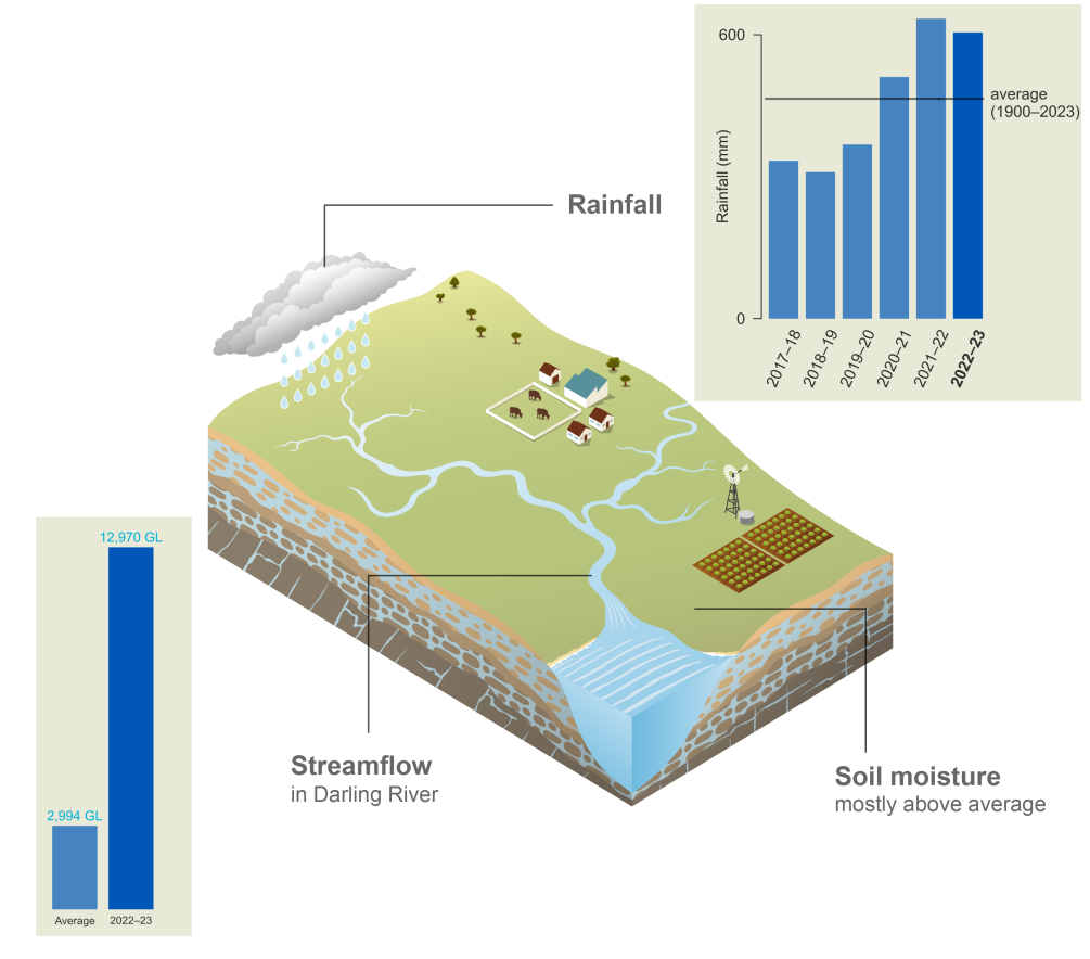
- Total area-averaged rainfall for the 2022–23 year was 605 mm, 30% more than the long-term average of 467 mm. This was the region's third consecutive year of above-average rainfall.
- Total annual rainfall was above average across much of the southern Basin and close to average for the northern Basin.
- A La Niña event in spring 2022 combined with a negative Indian Ocean Dipole (IOD) and a positive Southern Annular Mode (SAM), created favourable conditions for above-average rainfall across the Murray–Darling Basin from late winter through to summer.
- The Murray–Darling Basin had its wettest October and wettest spring on record, with an area-average September to November total of 292 mm exceeding the previous record by 45 mm. These conditions were due to periods of heavy rainfall associated with moist air being drawn down from the tropics and interacting with the passage of cold fronts.
- For more information on the record-breaking spring rainfall and flooding events, refer to the Special Climate Statement 77.
- 2022–23 summer was generally drier than average across much of the Basin with little to no rainfall in the western parts of the region during February.
- While dry conditions persisted in western and northern areas through autumn, rainfall was mostly average to above average across the southern Basin through to the end of the 2022–23 year.
- For more information on Australia's climate and water in 2022–23 visit the Bureau's Financial Year Climate and Water Statement 2022–23.
Figure C2 Total monthly rainfall for the Murray–Darling Basin region during the 2022–23 year compared with the average and percentiles for the region
- Monthly rainfall totals were close to or above the 90th percentile from August to November 2022, resulting in the wettest spring in the Basin since 1901.
- Rainfall during October was more than three times the monthly average and the highest on record, causing widespread and prolonged flooding across the Murray–Darling Basin.
- From December 2022 to June 2023, rainfall was close to or less than average, with February area-averaged rainfall below the10th percentile.
Actual evapotranspiration
Figure C3 Annual and monthly actual evapotranspiration deciles for the Murray–Darling Basin region during the 2022–23 year
- Total area-averaged actual evapotranspiration for 2022–23 was predominantly average to above average in the northern Basin and very much above average across much of the southern Basin.
- Evapotranspiration was above average for most of the northern Basin during late winter and early spring and then throughout the Basin during late spring.
- Record high spring rainfall increased landscape water availability and resulted in large areas of the southern Basin experiencing highest monthly evapotranspiration since 1901 during the latter half of spring.
- With close to or below average rainfall from December onwards, monthly evapotranspiration was average to below average across most of the region through to the end of the 2022–23 year, with below-average evapotranspiration more prominent for much of the northern Basin.
Soil moisture
Figure C4 Annual and monthly soil moisture deciles for the Murray–Darling Basin region during the 2022–23 year
- Soil moisture in the root zone (0–1 m depth) for the 2022–23 year was above average across much of the southern Basin and average to above average in the northern Basin.
- During late winter and early spring, soil moisture was predominantly above average across the northern Basin, becoming more widespread across the whole region during late spring.
- The region's wettest spring since 1901 resulted in large areas of the southern Basin experiencing highest on record root zone soil moisture during the latter half of spring.
- With average to below average rainfall from December, monthly soil moisture in much of the northern Basin was average to below average through to the end of 2022–23. However, in areas in the east and south of the region, soil moisture was average to above average during autumn and early winter following average to above-average rainfall during that period.
- More information on soil moisture conditions across the Murray–Darling Basin is available on the Australian Water Outlook.
Streamflow responses

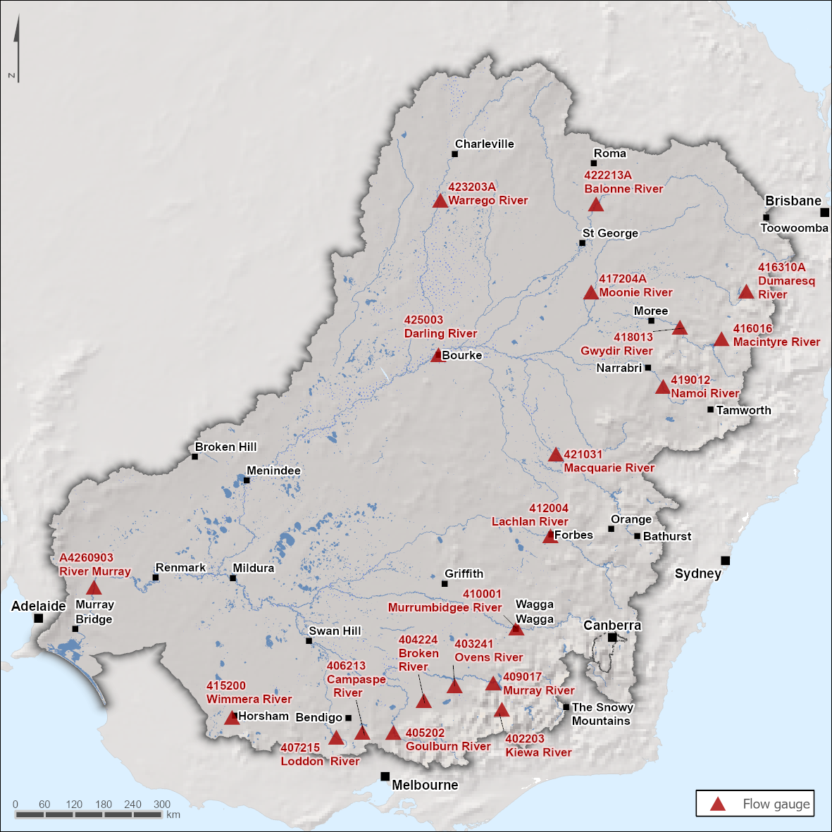
Figure C5 Key flow gauging stations along the main
rivers within the Murray–Darling Basin region
- The Murray and Darling rivers are the two primary river systems within the region. Streamflow in the Murray River is influenced by dam operations and diversions for consumptive use.
- The major tributaries of the Murray and Darling rivers in the southern part of the region are predominantly regulated while most of the major tributaries in the north are unregulated.
Figure C6 Total monthly flow for major rivers in the Murray–Darling
Basin region during the 2022–23 year compared with the average and percentiles
- Total annual flows in the Murray–Darling Basin's major rivers were above average in 2022–23, except for the Warrego River at Wyandra in the northwest, where streamflows were below average. Many streamflow sites across eastern New South Wales and Victoria recorded annual flows several times the annual average, including a few sites recording their highest annual flows on record.
- In the Darling River at Bourke Town (Station 425003), total annual flows were 12,970 GL, more than four times the annual average of 2,994 GL.
- Multiple heavy rainfall events from August to November caused prolonged periods of significant flooding to the region, particularly in the Lachlan, Macquarie, Darling, Murray-Riverina, Murrumbidgee, Namoi, (Queensland) Border Rivers, and Condamine catchments. Numerous gauges in the Basin registered their highest flows on record in October or November.
- Floodwaters in the Murray–Darling Basin gradually moved downstream, reaching the lower Darling and Murray rivers near the South Australian border by late December, causing major flooding for several weeks. The volume of flow deepened and widened the mouth of the Murray River.
- Streamflows in the northern Basin typically align with the northern wet season, remaining low during winter and spring, then peaking in summer before decreasing in volume throughout autumn and returning to base flows by winter. However, due to the widespread rainfall events between August and November, streamflows in the north of the Basin peaked in spring, returning to much lower than average flows from summer through to the end of June.
- Streamflows in the southern Basin remained close to average due to near average rainfall during the second half of the 2022–23 year.
Note: Streamflow data for the River Murray at Lock 1 Downstream (Station A4260903) was unavailable from December to February as the river level was too high to be reliably converted into a flow volume.


