


Seasonal Climate Outlook Archive
|
MEDIA RELEASE - ISSUED 13th OCTOBER 1999 Three-month Seasonal Climate Outlook Summary: Rainfall probabilities for November 1999 to January 2000Above median rainfall favoured in many areasThe National Climate Centre's latest outlook shows that for most of eastern and northern Australia, the chance of rainfall exceeding the median for the three month period November to January is between 55% and 65% (see map below). These probabilities imply an increased chance of an active start to the tropical wet season. Similar probabilities apply in the southwest of Western Australia. Elsewhere in the country, including the rainfall deficient parts of Victoria, Tasmania and South Australia, the chances of above median rainfall for the coming season are generally close to 50%. Indian Ocean temperatures, one of the inputs to the outlook, are the principal source of guidance in this release. They are warmer than average in a band stretching northwestward from the central coast of WA. The September Southern Oscillation Index (SOI) was zero, just marginally below the +2 recorded in August. The unofficial SOI for the 30 days ending 10th October is +1. Research as shown that small SOI values, such as these, at this time of year, point towards near normal tropical cyclone numbers during the following cyclone season. Sea temperatures in the tropical Pacific Ocean continued to cool during September, and despite the neutral SOI, are bordering on weak La Ni�a conditions near the Equator. Off the Equator, the pattern of sea temperatures is not typical of La Ni�a, which has a resulted in a near-neutral input to the Bureau's outlook system. Most of the available computer models are predicting neutral to weak La Ni�a conditions in the Pacific Ocean during summer and early autumn. In general, La Ni�a conditions increase the chances of wetter than average weather in eastern and northern Australia. For the current season, the forecast system shows most skill in the eastern halves of Queensland and New South Wales. For more information regarding this outlook please contact the following climate meteorologists in the National Climate Centre during normal office hours from 8:45am to 5:30pm (EST) Monday to Friday: Grant Beard on (03) 9669 4527 Archive of previous Seasonal Climate Outlooks September 1999 rainfall - Decile Distribution. July to September 1999 rainfall - Decile Distribution. |
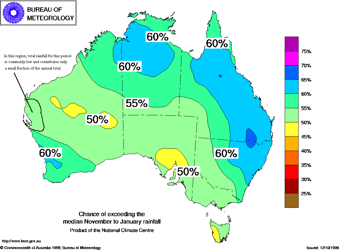
Click on the map for full resolution.
| Frequently Asked Questions |
|---|
|
Q: WHAT ARE THE BUREAU OF METEOROLOGY'S
SEASONAL CLIMATE OUTLOOKS? A:General statements about the probability or risk of wetter or drier than average weather over a three-month period. The outlooks are based on the statistics of chance (the odds) taken from rainfall and sea surface temperature records. They are not, however, categorical predictions about future rainfall, and they are not about rainfall within individual months of the three-month outlook period. Q: WHAT DO WE MEAN BY WETTER OR DRIER THAN "AVERAGE", OR WARMER OR COOLER THAN "AVERAGE"? A:Being above or below the MEDIAN rainfall, MEDIAN maximum temperature, or MEDIAN minimum temperature over the three-month outlook period. The median is the middle value in the historical record for the period in question. In the long term, rainfall or temperature are above median in one half of years, and below median in the other half. Example 1: For the July to September period at Mackay in Queensland, one-half of 3-month rainfall totals have been below 80mm, and one-half have been above. If rainfall was above 80mm in that period it would be "wetter than average" or above median. Over the long haul there is a 50% chance of this occurring. In terms of odds this is even money. Example 2: In Sydney, one-half of summers (Dec-Feb) have a mean maximum temperature above 25.7°C, with the other half being below. Therefore 25.7°C is the median. Note that the mean or average maximum temperature is the average of all the daily highest temperatures for the period. Similarly, the mean or average minimum temperature is the average of all the daily lowest temperatures for the period Q: HOW ACCURATE ARE THE OUTLOOKS? A: In the places and seasons where the outlooks are most skilful, the category of the eventual outcome (above or below median) is consistent with the category favoured in the outlook about 75% of the time. In the least skilful areas, the outlooks perform no better than random chance or guessing. The rainfall outlooks perform best in eastern and northern Australia between July and January, but are less useful in autumn and in the west of the continent. The skill at predicting seasonal maximum temperature peaks in early winter and drops off marginally during the second half of the year. The lowest point in skill occurs in early autumn. The skill at predicting seasonal minimum temperature peaks in late autumn and again in mid-spring. There are also two distinct periods when the skill is lowest - namely late summer and mid-winter. However, it must always be remembered that the outlooks are statements of chance or risk. For example, if you were told there was a 50:50 chance of a horse winning a race but it ran second, the original assessment of a 50:50 chance could still have been correct. Q: WILL CATEGORICAL OUTLOOKS EVER BE ISSUED? (Eg. It WILL be drier than average.) A: Very unlikely. There is a certain level of natural variability in the climate which is chaotic and unpredictable. This is particularly the case with rainfall. For example, rainfall in a season can be significantly above average in one region, and significantly below average less than 50km away. Q: HOW SHOULD THE OUTLOOKS BE USED? A: As another tool in risk management and decision making. The benefits accrue from long-term use, say over 10 years. At any given time, the probabilities may seem inaccurate, but taken over several years, the advantages of taking account of the risks will outweigh the disadvantages. For more information on the use of probabilities, farmers could contact their local departments of agriculture or primary industry. |
| Definitions and Explanations.... |
|---|
|
THE SOUTHERN OSCILLATION INDEX (SOI) is calculated using the barometric pressure difference between Tahiti and Darwin. The SOI is one indicator of the stage of El Ni�o or La Ni�a events in the tropical Pacific Ocean. It is best considered in conjunction with sea-surface temperatures, which form the basis of the outlooks. A strongly negative SOI (below -10) is characteristic of El Ni�o, which is often associated with below average rainfall over eastern Australia, and a weaker than normal monsoon in the north. A strongly positive SOI (above +10) is characteristic of La Ni�a, which is often associated with above average rainfall over parts of tropical and eastern Australia, and an earlier than normal start to the northern monsoon season. El Niño & La Niña El Ni�o translates from Spanish as "the boy-child", and refers to the extensive warming of the central and eastern Pacific Ocean. La Ni�a translates from Spanish as "the girl-child", and refers to the extensive cooling of the central and eastern Pacific Ocean. The term has recently become the conventional label for the opposite of El Ni�o. See http://www.bom.gov.au/climate/glossary/elnino.shtml for more on SOI and El Ni�o. |
[an error occurred while processing this directive]