
AUSTRALIAN GOVERNMENT BUREAU OF METEOROLOGY
TROPICAL CYCLONE WARNING CENTRE BRISBANE
| Community Threat | Past Cyclone Details | ||||||||||||||||||||||||||||||
|
|
||||||||||||||||||||||||||||||
| Current Cyclone Details | Forecast Cyclone Details (at 24 and 48 hours from issue) |
||||||||||||||||||||||||||||||
|
|
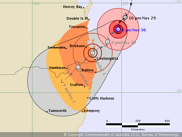
The forecast path shown above is the Bureau's best estimate of the cyclone's future movement and intensity. There is always some uncertainty associated with tropical cyclone forecasting and the grey zone indicates the range of likely tracks of the cyclone centre.
Due to the uncertainty in the future movement, the indicated winds will almost certainly extend to regions outside the rings on this map. The extent of the warning and watch zones reflects this.
This product is designed for land-based communities; mariners should read the coastal waters and high seas warnings.
Remarks:
SEVERE TROPICAL CYCLONE JONICA, CATEGORY 3, is expected to cross the coast near the Gold Coast Sunday morning.
VERY DESTRUCTIVE WINDS are currently within 30 kilometres of the centre and
DESTRUCTIVE WINDS extend 55 kilometres out from the centre.
GALES extend 130 kilometres out from the centre and are possible between Double Island Point and Grafton
Coastal residents are specifically warned of the dangerous storm tide as the cyclone crosses the coast. The sea is likely to rise steadily up to a level which will be significantly above the
normal tide, with damaging waves, strong currents and flooding of low-lying areas extending some way inland. People living in areas likely to be affected by this flooding should take measures to protect their property as much as possible and be prepared to follow instructions regarding evacuation of the area if advised to do so by the authorities.
– People in the path of the very dangerous cyclone should stay calm and remain in a secure shelter – above the expected water level – while the very destructive winds continue.
– Do not venture outside if you find yourself in the eye of the cyclone – (very) destructive winds from a different direction could resume at any time.
– Follow the evacuation advice or directions of Police, Emergency Services personnel and local authorities.
Name: Severe Tropical Cyclone Jonica
Details:
| Time (EST) | Intensity Category | Latitude (decimal deg.) |
Longitude (decimal deg.) |
Estimated Position Accuracy (km) |
|
|---|---|---|---|---|---|
| 0hr | 9 am November 30 | 3 | 26.5S | 154.8E | 60 |
| +6hr | 3 pm November 30 | 3 | 26.7S | 154.4E | 80 |
| +12hr | 9 pm November 30 | 3 | 27.2S | 154.2E | 100 |
| +18hr | 3 am December 1 | 3 | 27.5S | 153.7E | 125 |
| +24hr | 9 am December 1 | 3 | 27.8S | 153.4E | 145 |
| +36hr | 9 pm December 1 | 2 | 28.6S | 152.6E | 180 |
| +48hr | 9 am December 2 | tropical low | 29.4S | 151.7E | 220 |
The next Forecast Track Map will be issued by 12:00 pm EST Saturday
