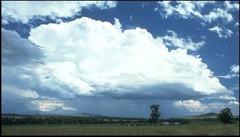
Australian Storm Spotters' Guide2. Types of Storms There are three simplified thunderstorm types: the single-cell, the multicell, and the supercell. Of these, it is the multicell which is the most common. This photograph ( 2.1) of a multicell storm near Tamworth, NSW, illustrates many of the features we discussed in Section 1. The flanking line can be seen extending from the lower right of the photo in a series of steps up to the well defined anvil in the top left. Rain falls below a relatively flat base in the form of a diffuse rain curtain. Although on first appearance, this storm is unlikely to be severe, multicells have been known to produce all the severe effects, but cause tornadoes only infrequently.
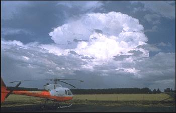
A supercell thunderstorm is a special storm type which maintains an intense steady-state for many hours. This photograph (2.2) shows a supercell storm near Fiskeville, Victoria. Note the high, crisp anvil, which indicates a very strong, sustained updraught. Supercells are a fascinating but dangerous cloud complex and they account for most of the serious thunderstorm events we experience.
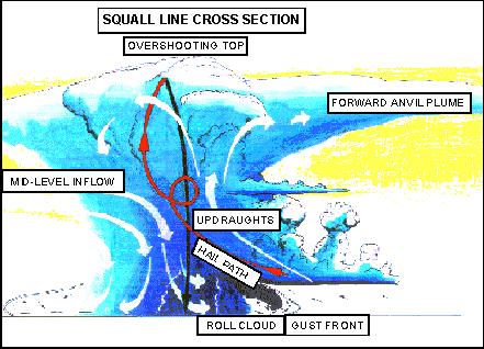
Thunderstorms don't always occur as single entities. Often, many storm cells will group together in a line, aligned with a cold front or a low pressure trough. These storm complexes are referred to as squall lines because of the strong, squally winds they can produce. Sometimes they also generate tornadoes, particularly in southern parts of Australia during the cooler months. This diagram (2.3) shows a vertical cross-section of a squall line storm cell which is moving quickly towards the right of the screen. The gust front moves along with the storm, helping to fuel the updraught and prolong the storm's life. A shelf or detached roll cloud is a common feature of these storms.
|