


This document describes the flood risk and previous flooding in the Condamine River catchment.
Last
updated: July 2026.
Note this brochure refers to the Condamine River between Pratten and Warkon, for information on Myall Creek,
the Upper Condamine or Balonne River please see the relevant brochure.
Flood Risk
The Condamine - Balonne River system is one of the tributaries of the Murray - Darling River system and is one of the most important river systems in Queensland in terms of agriculture. The headwaters of the Condamine River rise in the Border Ranges near Killarney and flow approximately 1200 kilometres through Queensland before entering New South Wales.
Downstream of Tummaville, the river splits into multiple channels, before rejoining into a main channel downstream of Cecil Plains. A number of important tributaries feed into the Condamine River, including but not limited to,
- Hodgson Creek, which joins near Tummaville
- Oakey Creek, which arises near Toowoomba and joins the Condamine upstream of Loudon Bridge
- Myall Creek, which passes through Dalby before joining downstream of Loudon Bridge
- Charley's Creek, which passes through Chinchilla before joining the Condamine downstream of Chinchilla Weir.
The annual rainfall distribution ranges from over 1000 mm in the ranges near Killarney to only 400 mm over the lower parts of the catchment near Hebel.
Upper parts of the tributaries of the Condamine are prone to flash flooding, including Jandowae and Toowoomba, where dangerous flooding can arise with limited lead time, impacting homes and properties. On the Condamine River itself, flooding tends to be slower and takes many days to move through the system. Flooding of the Condamine River can result in widespread damage to fencing, pumping equipment, machinery and loss of stock through drowning, resulting in significant losses during major floods through rural areas.
Chinchilla primarily floods following heavy rainfall in the upper catchment of Charley's Creek, with widespread property inundation possible in major flood events. Flooding on the Condamine River can back up water into Charley's Creek but is not typically as significant as flood emanating from the creek itself.
Major floods on the Condamine River can develop from both heavy rainfall in the headwater areas of the catchment or any of the large tributaries which enter the main Condamine River. Because of this, flood forecast lead times can vary significantly. It is not uncommon to have multiple flood peaks in the river system as floodwaters join the main river from the various tributaries or from multiple rainfall events.
The following can be used as a rough guide to the likelihood of flooding in the catchment:
- Average catchment rainfalls in excess of 25 mm with isolated 50 mm falls in 24 hours may result in stream rises and the possibility of minor flooding and local and downstream traffic disruptions.
- Average catchment rainfalls in excess of 50 mm with isolated 75 to 100 mm falls in 24 hours may result in significant stream rises and the possibility of moderate to major flooding developing with local traffic disruptions.
Previous Flooding
Records of large floods along the Condamine extend back as far as 1887 at Warwick, with extensive records at several other locations on the mainstream. Major floods occur regularly, on average every 2 years. The worst flooding occurred in 1942, 1950, 1956, 1975, 1976, 1983 (twice), 1988, 1996 and two very large floods two weeks apart at the end of 2010 and start of 2011. Major floods generally only occur in the first half of the year although records indicate that they may also occur in late spring.
The 2010-11 floods were the highest on record for many locations along the Condamine River and followed months of above average rainfall in the lead-up. The remnants of Cyclone Tasha brought widespread heavy rain and major flooding to the region in December. Shortly following this in January, a stationary trough led to devastating flash flooding through Toowoomba, with water moving into already flooded waterways. Significant loss of life occurred, along with widespread community disruption and property damage. The town of Condamine was evacuated by helicopter and flood boat twice in a matter of months.
More recently, four major flood events occurred between Spring 2021 to Autumn 2022, culminating in a major flood peak of 12.25 at Condamine on the 7th of December, that damaged several properties and cut numerous roads in the region.
During March 2026, heavy rainfall affected a broad swathe of central and southeastern Queensland between March 7th and 10th. Two-day rainfall totals of 100 to 200 mm were observed broadly across the northern Darling Downs in the 48 hours to 9am on March 9th, with some localized higher accumulations also reported. Miles (Constance Street) recorded a 24-hour rainfall total of 135.8 mm to 9am on the 8th, a March record for this site. This resulted in major flooding along the Condamine River around Chinchilla and further downstream. Chinchilla (Charley's Creek) peaked at 6.41m, with water flooding into town.
The table below shows some of the heights reached in past flood events across the Condamine River catchment.
Previous flooding events
| Flood Event | Tummaville | Cecil Plains | Chinchilla (Charley's Creek) | Chinchilla Weir | Condamine |
| June 1956 | - | 8.84 | - | 13.87 | 14.14 |
| February 1976 | 11.19 | 9.20 | - | 13.90 | 12.74 |
| April 1988 | 10.60 | - | - | 14.20 | 13.80 |
| December 2010 | 11.15 | 9.22 | 7.24 | 15.38 | - |
| January 2011 | 10.85 | 8.77 | 7.45 | 14.39 | 15.25 |
| January 2013 | 10.70 | 8.28 | 6.55 | 12.41 | 11.70 |
| April/May 2022 | 10.19 | 8.24 | 5.22* | 11.51 | 10.5 |
| March 2026 | - | - | 6.41 | 8.97 | 8.10 |
All heights are in metres on flood gauges.
* Recorded in February 2022
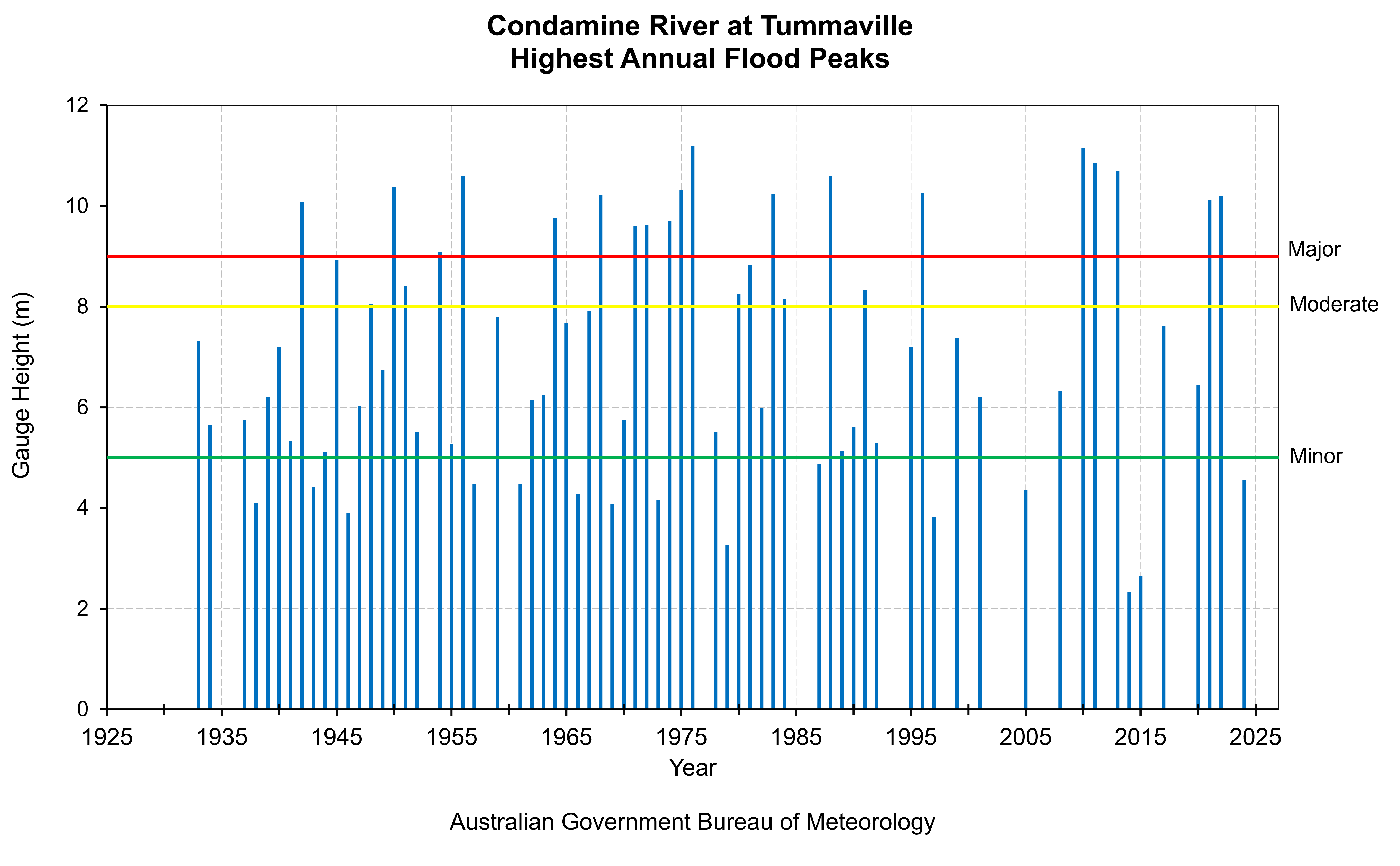
This chart shows flood level classifications of recorded flood gauge height observations of the Condamine River at Tummaville.
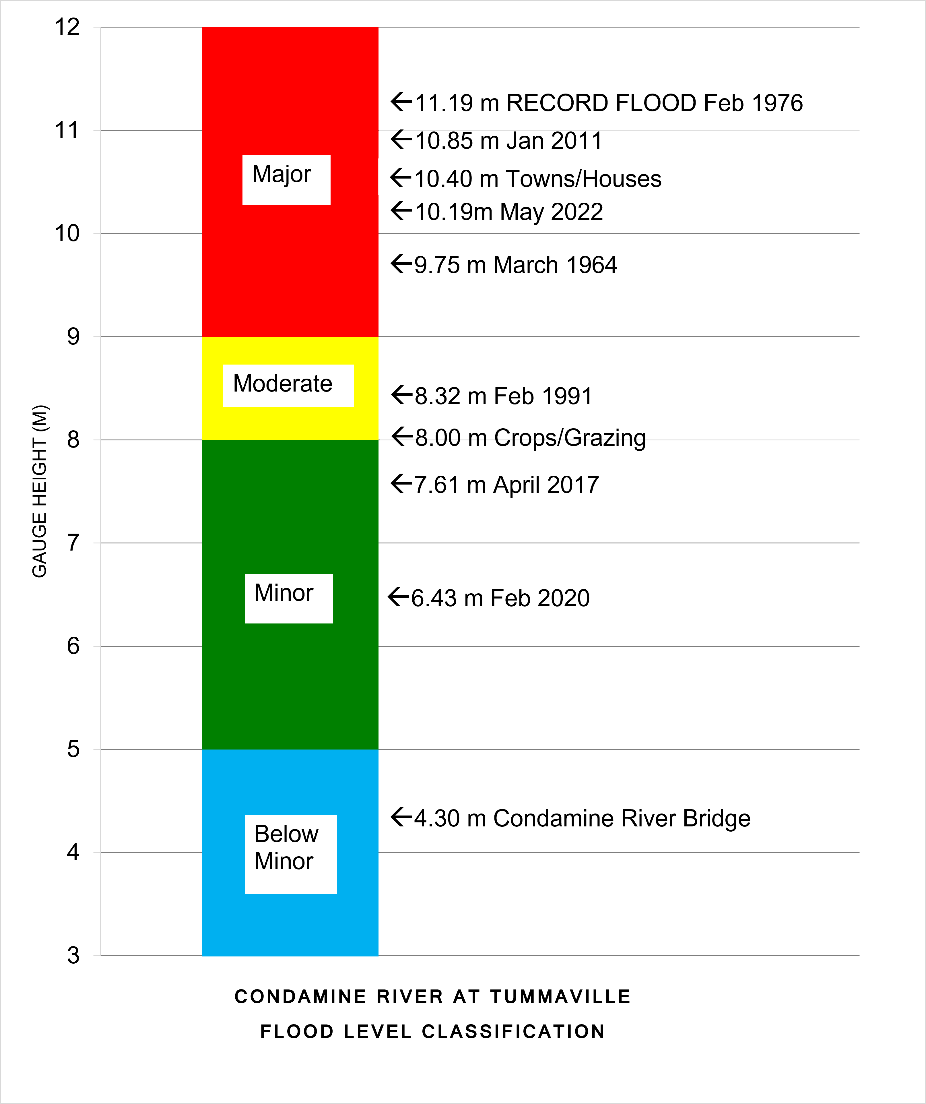
The totem pole shows flood level classification and associated impacts related to local reference sites, along with recorded flood gauge height observations of notable flood events that have occurred on the Condamine River at Tummaville.
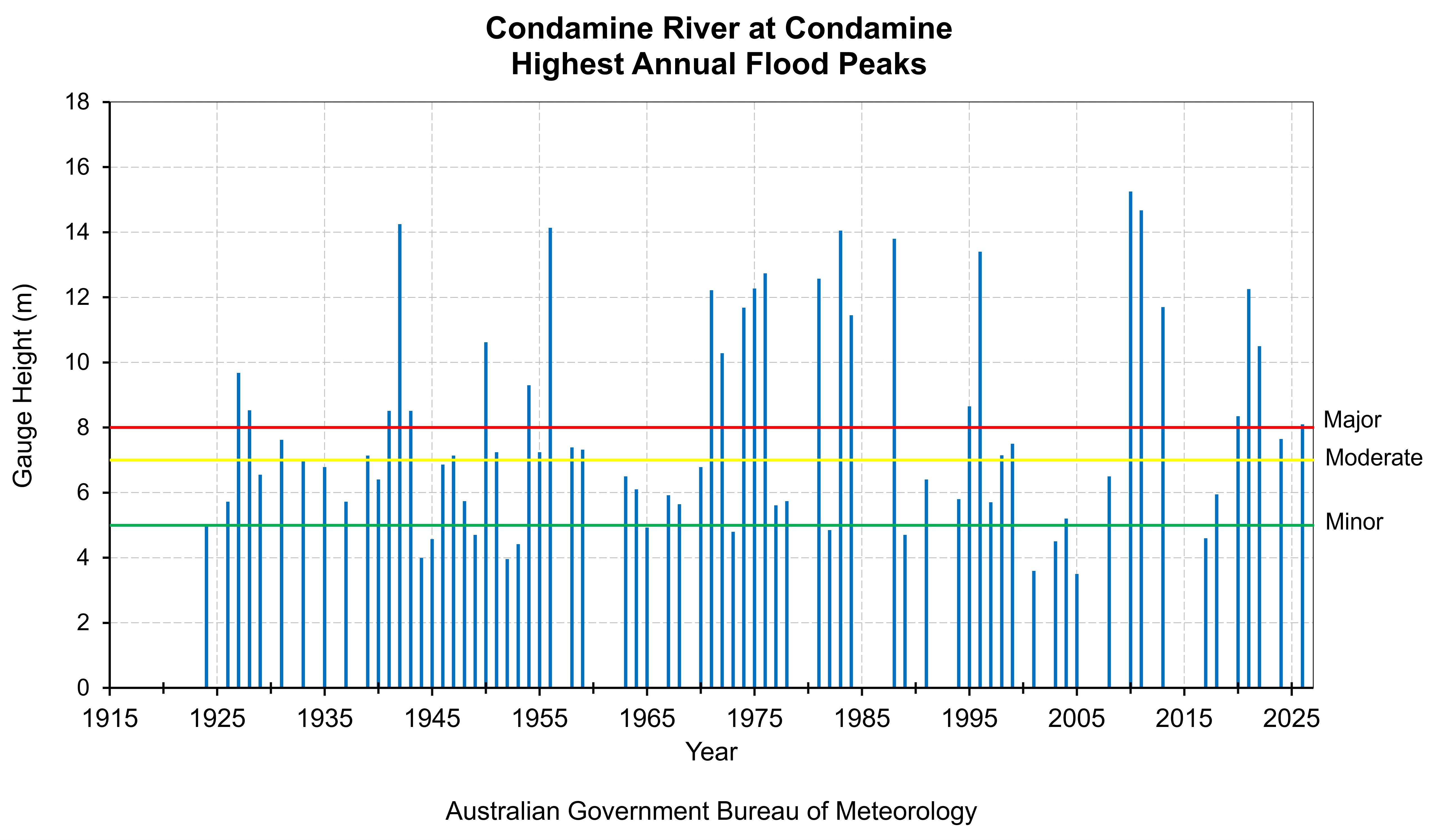
This chart shows flood level classifications of recorded flood gauge height observations of the Condamine River at Condamine.
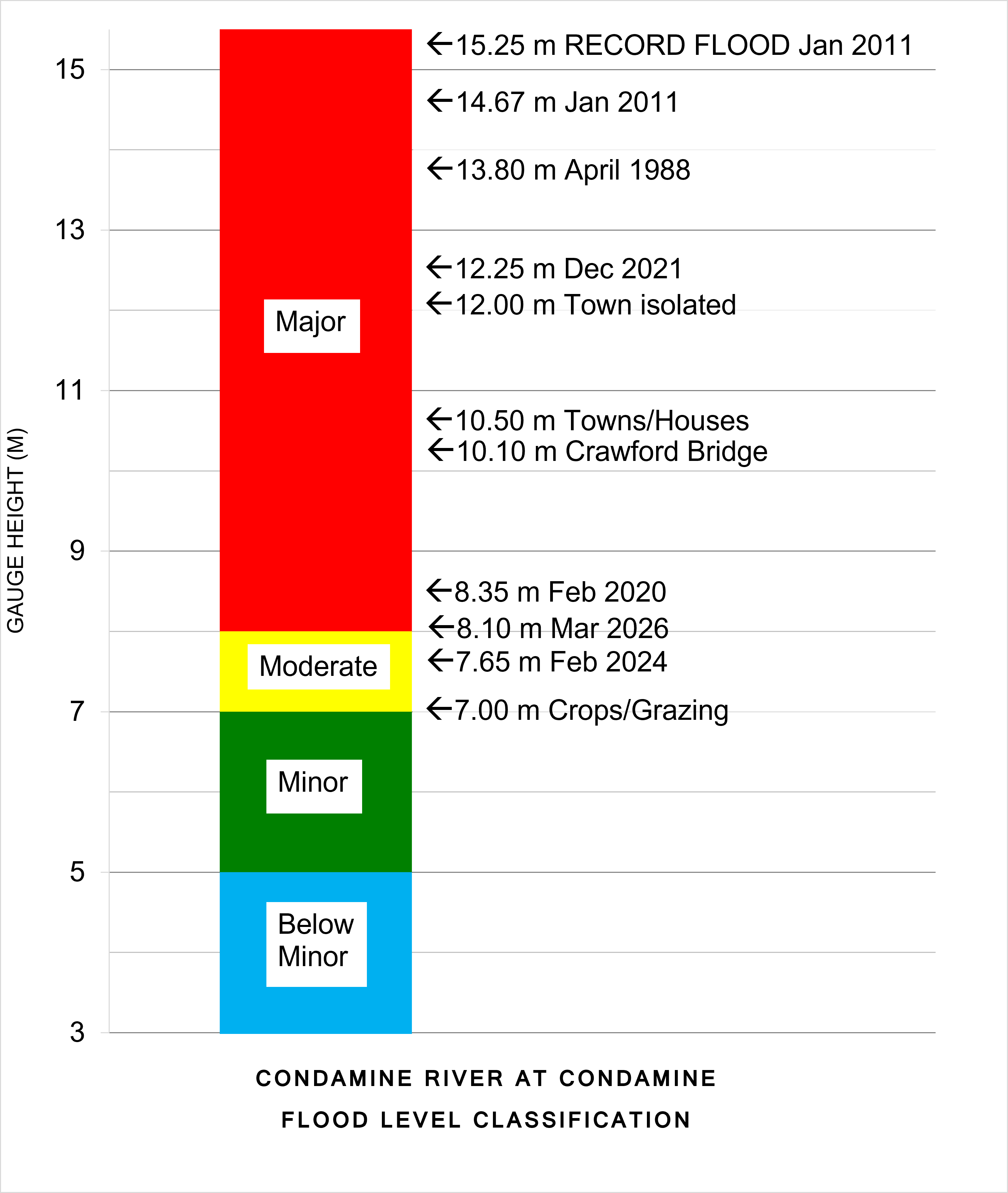
The totem pole shows flood level classification and associated impacts related to local reference sites, along with recorded flood gauge height observations of notable flood events that have occurred on the Condamine River at Condamine.
Further Information:
- Latest rainfall and river heights
- Flood warning service for the Condamine River: Queensland Service Level Specification
- Catchment map: Queensland Condamine-Balonne Basin map
- National Arrangements for Flood Forecasting and Warning