


| This document describes the flood risk and previous flooding in the Burdekin River catchment. |
| Last updated: April 2026. |
Flood Risk
The Daintree River catchment is located about 100 kilometres northwest of Cairns in far north tropical Queensland and drains an area of 2125 square kilometres. The river rises in the Great Dividing Range, approximately 40 kilometres northwest of Mossman. It initially flows in a northerly direction before turning southeast, passing Daintree, and finally entering the Coral Sea.
Floods may develop quickly and with little warning from high rainfalls on the 1000 metre high mountain ranges around the catchment, and are often caused by cyclonic influences in the adjacent Coral Sea.
The Mossman River is a shorter river arising to the west of Mossman, before draining east through Mossman Gorge and into the Coral Sea. Being a shorter river, the Mossman River is prone to rapid rises and flash flooding during periods of heavy rainfall.
Previous Flooding
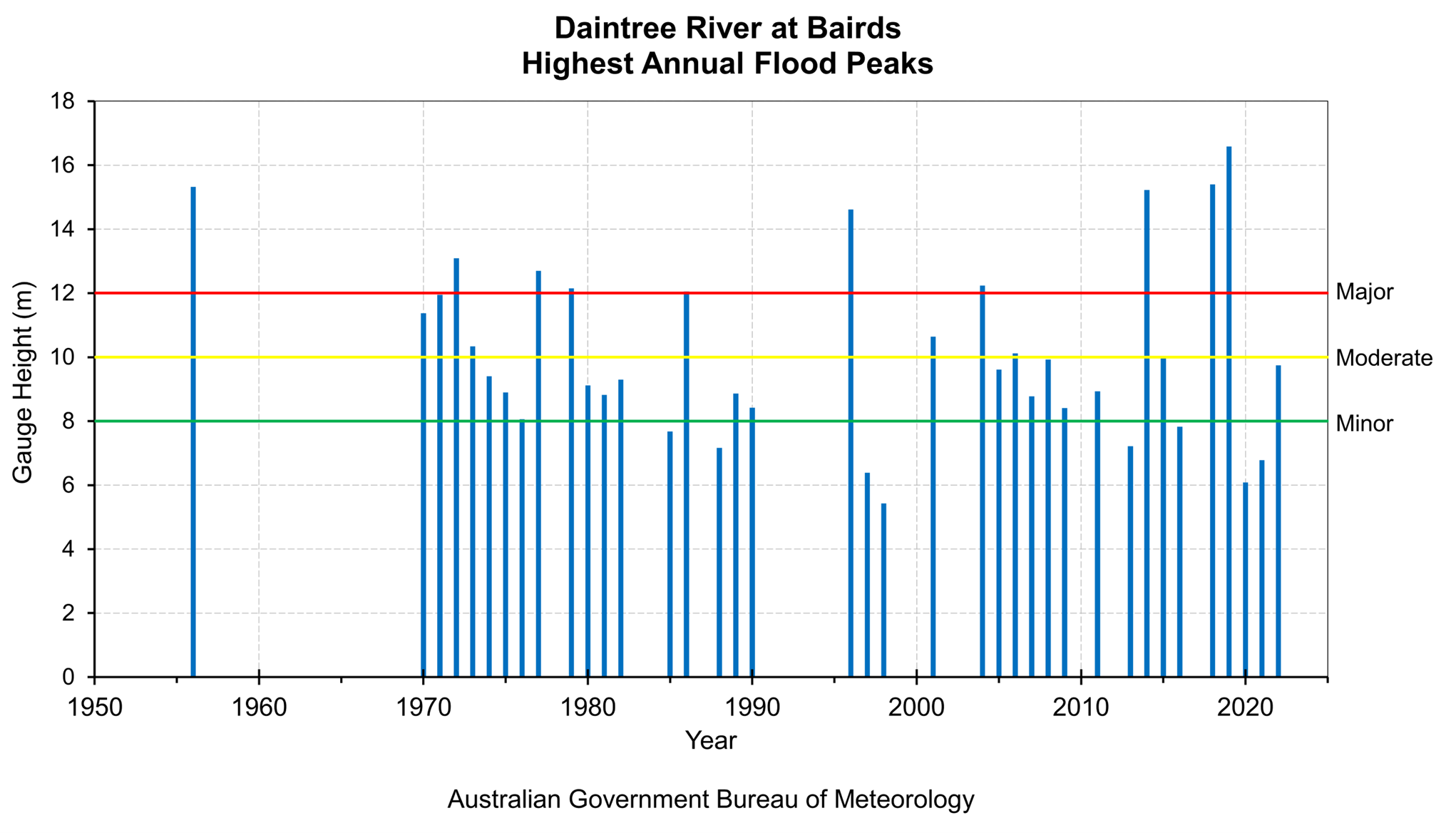
Historical flood information for the Daintree River catchment is limited. However, river height records are available from the automatic river height station at Bairds, with continuous records dating back to 1968.
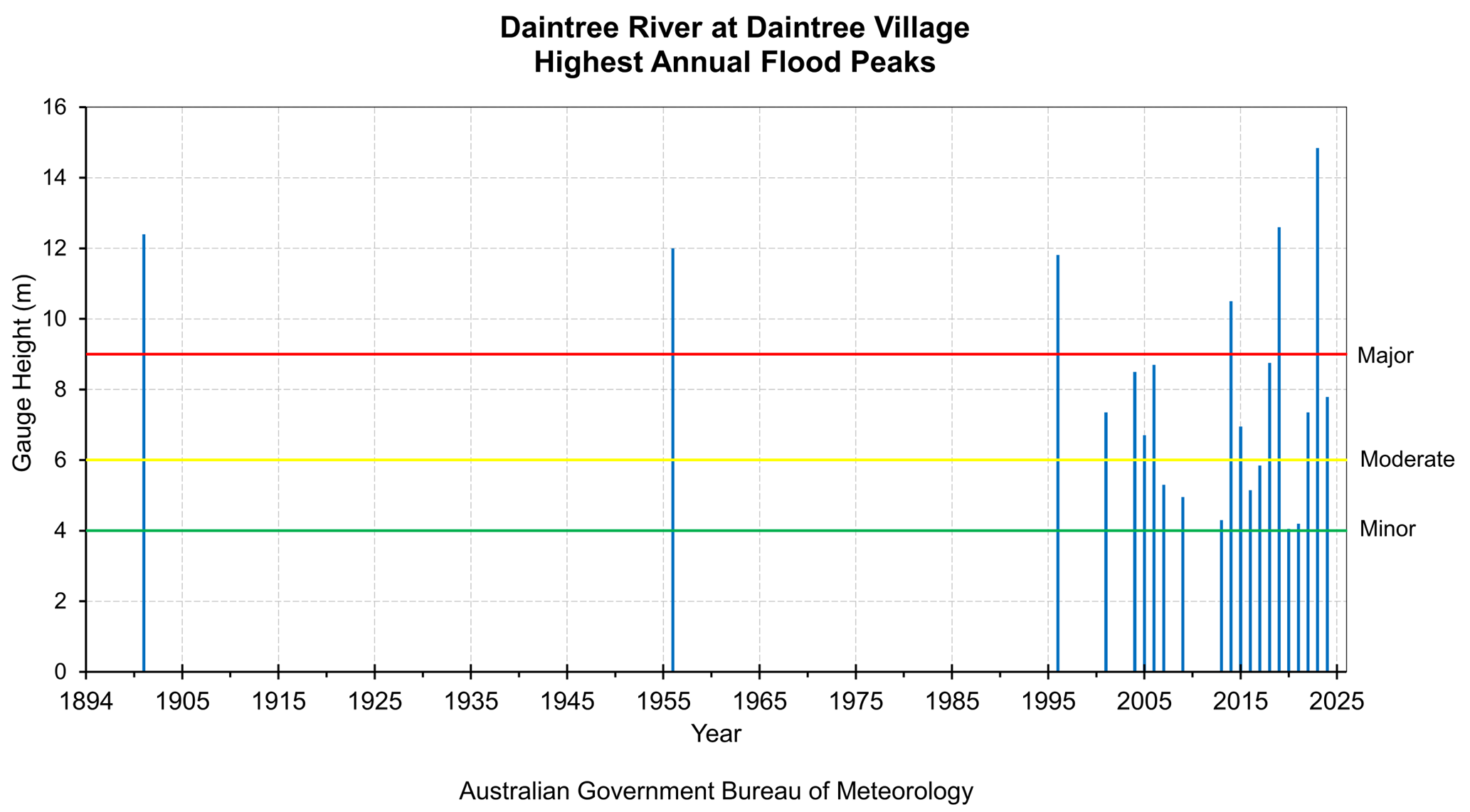
An automatic flood warning river height station was installed at Daintree Village in 2015. Significant recent floods include January 2019, and December 2023.
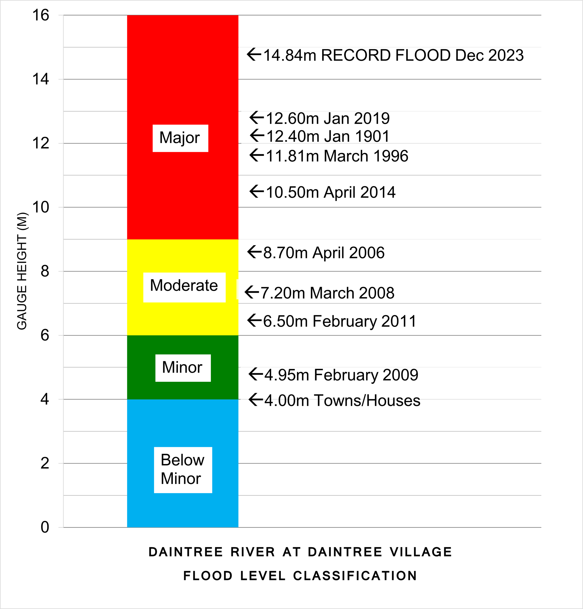
In 2019, widespread thunderstorm development during the afternoon and evening of 26 January resulted in intense rainfall across the Bloomfield, Daintree, and Mossman River catchments. The highest flood level recorded for the Daintree River at Daintree Village was 12.60 m on 26 January 2019 at 11:55 pm.
In 2023, Tropical Cyclone Jasper crossed the North Queensland coast as a Category 2 system on Wednesday evening 13 December near Wujal Wujal, bringing widespread heavy rain. Tropical Cyclone Jasper transitioned to a tropical low after making landfall and then moved slowly west over Cape York Peninsula before becoming near stationary over the northern Gulf Country. Linked to ex-Tropical Cyclone Jasper, a coastal trough developed and brought further widespread heavy to locally intense rainfall across the North Queensland coast.
The Daintree River catchment recorded rainfall totals between 1799 mm and 2155 mm for the period 13 to 18 December 2023, with rainfall totals most significant in the upper parts of the catchment. A Major flood peak of 14.85 m was recorded at the forecast location of Daintree Village at 4:00 am on 18 December 2023. This peak flood level was 2 metres higher than the previous record of 12.60 m in January 2019.
A peak height at Bairds for the December 2023 event is not available due to damage sustained by the river level gauge. However, based on the record river level observed downstream at Daintree Village during this event, it is highly likely that the river level at Bairds also exceeded all previous recorded floods by a significant margin. The highest recorded flood peak at Bairds is 16.58 m in January 2019, estimated from a flood mark.
The Mossman River catchment recorded a rainfall total of 2049 mm for the period 13 to 18 December 2023. The highest flood level recorded for the Mossman River at Mossman was 8.98 m on 17 December 2023 at 7:00 pm.
The Bloomfield River catchment at China Camp recorded rainfall totals between 1620 mm and 2030 mm for the period 13 to 18 December 2023. The highest flood level recorded during this period for the Bloomfield River at China Camp was around 8.73 m on 17 December 2023 at 9:45 pm. At 9:57 pm the river level gauge appears to have become unreliable. The Bloomfield River at China Camp may have peaked higher than what has been recorded.
Previous flooding events
| Flood Event | Bairds | Daintree Village | Mossman | China Camp |
| April 2014 | 15.23 | 10.50 | 8.65 | 8.92 |
| January 2019 | 16.58 | 12.60 | 8.27 | 8.92 |
| December 2023 | 17.07+* | 14.85 | 8.98 | 8.73+* |
| March 2026 | 13.87 | 8.85 | 7.58 | 7.68 |
Further Information:
- Latest rainfall and river heights
- For information on the flood warning service for the Daintree River: Queensland Service Level Specification
- Catchment map: Daintree River map
- National Arrangements for Flood Forecasting and Warning