


This document describes the flood risk and previous flooding in the Fitzroy River catchment.
Last updated: April 2026.
Flood Risk
Due to its large catchment area (~140,000 km2) and fan-like shape, the Fitzroy River Catchment is prone to severe flooding following prolonged heavy rainfall events. Its major tributaries, the Dawson, Mackenzie, Isaac and Connors rivers rise in the eastern coastal ranges and in the Great Dividing Range and join about 100 kilometres west of Rockhampton. Major floods can result from either the Dawson or the Connors-Isaac-Mackenzie rivers. Significant flooding in the Rockhampton area can also occur from heavy rain in the local area downstream of Riverslea.
The headwaters of the Connors-Isaac River catchment are susceptible to high rainfall totals, with coastal rainfall often affecting the Mackay hinterland and Cardowan Range. The Connors-Isaac River headwaters area typically produces the peak flow runoff which ultimately causes Rockhampton’s flood to peak usually between 7 to 10 days later (sometime in combination with high Dawson River flows).
The main population centres at higher risk of extensive urban inundation are Rockhampton, Emerald, Biloela, Taroom, and Theodore.
Fairbairn Dam is Queensland's second largest dam and is located on the Nogoa River upstream of Emerald. It was constructed in 1972 and is owned by SunWater, with the main purposes being for irrigation, water supply and flood mitigation. Lake Maraboon, the resulting reservoir, has a capacity of approximately 3 times that of Sydney Harbour.
High level flooding along the Dawson River can require total evacuation of Theodore (aerial evacuation in 2010/11) and a similar situation along the Nogoa River has potential to cause evacuation (by rail) of Emerald township from the western side to the eastern side of the River. Extensive flooding of coal mining and agricultural infrastructure occurs on the floodplains of the Nogoa, Comet, Mackenzie and Dawson Rivers.
Flash flood risk locations include:
- • Banana Shire: Biloela, Jambin, Goovigen, Wowan;
- • Central Highlands: Gemfields (Rubyvale and Sapphire),
- • Isaac Region: Cardowan, Clermont, Dysart, Moranbah, Nebo
Flash flooding, particularly in the Gemfields creeks to the west of Emerald, including at Rubyvale and Sapphire, poses a high risk to life of communities and prospectors, i.e., camping on dry riverbeds. Clermont is also very vulnerable to flash flooding from Theresa Creek, with one of Australia's worst flash flood disasters leading to 61 deaths in 1916 as a cyclone moved across the region.
Previous Flooding
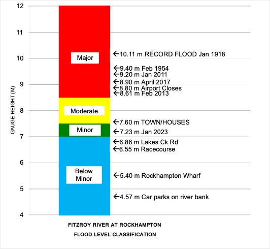
The Fitzroy River at Rockhampton has a long and well documented history of flooding with flood records dating back to 1859. The highest recorded flood occurred in January 1918 and reached 10.11 metres on the Rockhampton gauge. Over the last fifteen years Rockhampton has exceeded the major flood level three times (2011, 2013, and 2017 (TC Debbie)); with the most significant of these three being 2011 when the Fitzroy River reached 9.20 metres on the Rockhampton gauge. This period also provided the towns of Emerald, Rolleston and Theodore with their largest floods on record. Several hundred properties in Jambin and Biloela were flooded during the TC Marcia flood event in 2015. Biloela Alert station recorded 8.2 metres (4 m above its major level) in February 2021. Other significant flood events of note include 1954 and December 2010.
A feature of flooding at Rockhampton is its long duration, for example: the 1918 flood sustained levels above 7 metres for about 27 days and above 9 metres for 20 days; the 1954 flood sustained levels above 7 metres for 18 days; the 1991 flood remained above 7 metres for 20 days.
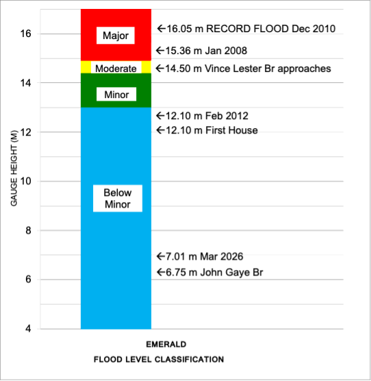
The Nogoa River at Emerald is prone to major flooding following widespread heavy to intense rainfall upstream of Fairbairn Dam. The most recent major floods were recorded in 2008 and 2010. In 2008 a tropical low moved south across the central interior after crossing the coast near Burketown. Widespread 5-day rainfall totals of 300 to 500 mm were recorded across the catchment upstream of Fairbairn Dam, with a top total of 697 mm at Bogantungan. This led to flood levels the highest since 1950 at Emerald, and the second highest (at the time) on record). Over 2500 people were evacuated and 380 houses were flood affected.
The 2008 flood in Emerald was eclipsed by flooding less than 3 years later in December 2010. After a very wet few months, heavy to intense rainfall was recorded in the upper Nogoa catchment. 24-hour rainfall totals of over 400 mm were recorded in the Carnarvon ranges. Over 80% of Emerald was inundated, with the Nogoa River peaking at a record level of 16.04 m. The Major flood level (15m) was exceeded from December 30 to January 2.
In January 2026, ex-Tropical Cyclone Koji crossed the coast between Ayr and Bowen on Sunday morning 11 January, before moving inland and weaken over the following days across inland northern and central Queensland. Two-day accumulated rainfall amounts of 200 to 500 mm were recorded across a broad swathe of central Queensland between Saturday 10 and Monday 12 January resulting in widespread flooding. 120 properties in Clermont were impacted by significant flash flooding due to intense rainfall overnight on Sunday, with 203 mm recorded at Clermont Airport in the 24 hours to Monday 12 January.
Observed rainfall over this 2-day period ranged from two to four times the average January rainfall for the region.
In March 2026, the remnants of tropical low 29U combined with a trough moving across the south of the state and brought widespread heavy rainfall to a broad swath of inland central and southeastern Queensland. Unlike the previous rain event in January, the highest accumulated rainfall totals were observed over the upper reaches of the catchment over areas west and south of Emerald. Already saturated catchments resulted in rapid river rises moderate to major flooding in parts of the Nogoa, Dawson and Comet Rivers. Observed flood peak in the lower reaches of the catchment were generally much lower than those observed during January’s flood event.
Previous flooding events on the Nogoa, Mackenzie, Isaac and Fitzroy Rivers
| Flood Event | Emerald | Yatton | Tartrus | Yaamba | Rockhampton |
| January 1918 | – | – | – | 17.32 | 10.11 |
| February 1954 | 14.12 | – | – | 16.59 | 9.40 |
| January 1991 | – | 17.64 | 15.74 | 16.65 | 9.30 |
| January/February 2008 | 15.36 | 17.07 | 16.20 | 14.25 | 7.75 |
| December 2010/January 2011 | 16.05 | 16.54 | 16.34 | 16.55 | 9.20 |
| February 2013 | – | 10.84 | 15.86 | 15.70 | 8.61 |
| April 2017 | – | 19.68 | 18.29 | 16.10 | 8.90 |
| January 2026 | – | 17.66 | 16.25 | 14.00 | 7.24 |
| March 2026 | 7.01 | 11.58 | 9.50 | 11.05 | 5.36 |
All heights are in metres on flood gauges.
Previous flooding events on the Dawson River, Callide and Kroombit Creeks
| Flood Event | Taroom | Theodore | Moura | Baralaba | Jambin |
| February 1918 | 8.23 | – | – | – | – |
| April 1928 | 7.52 | 12.89 | – | 15.85 | – |
| February 1956 | 9.27 | 14.07 | 12.90 | 13.18 | – |
| August/September 1998 | 7.46 | 11.83 | 11.34 | 10.65 | – |
| May 1983 | 7.42 | 13.24 | 12.09 | 13.60 | – |
| December 2010/January 2011 | 10.43 | 14.70 | 12.66 | 15.25 | 5.00 |
| December 2021 | – | 12.24 | – | – | – |
| March 2026 | 6.41 | 11.66 | – | – | 5.45 |
All heights are in metres on flood gauges.

Further Information:
- Latest rainfall and river heights
- For information on the flood warning service for the Fitzroy River: Queensland Service Level Specification
- Catchment map: Queensland Fitzroy Basin map
- National Arrangements for Flood Forecasting and Warning