


This document describes the flood risk and previous flooding in the Kolan River and Baffle Creek catchment. Last updated: April 2026.
Flood Risk
The Kolan River Catchment is located in southeast Queensland and covers an area of approximately 3,000 square kilometres. The river rises in the rugged Dawes Range, 100 kilometres northwest of Bundaberg. It meanders for a distance of 70 kilometres, generally in a southeasterly direction, before entering Lake Monduran and passing through the Fred Haigh Dam.
Below the Dam and the Bucca Range, the Kolan River enters a wide coastal plain, generally under large areas of sugar cane cultivation. Gin Gin Creek, its major tributary, rises in the Burnett Range 35 kilometres west of Gin Gin and flows in an easterly direction joining the Kolan River 10 kilometres above Bucca Weir.
Floods normally develop in the headwaters of the Kolan River and Gin Gin Creek and its major tributaries. However, Fred Haigh Dam has a significant effect on reducing major flooding in the lower reaches. Flooding from local area heavy rainfall may still occur in areas downstream of Bucca Weir.
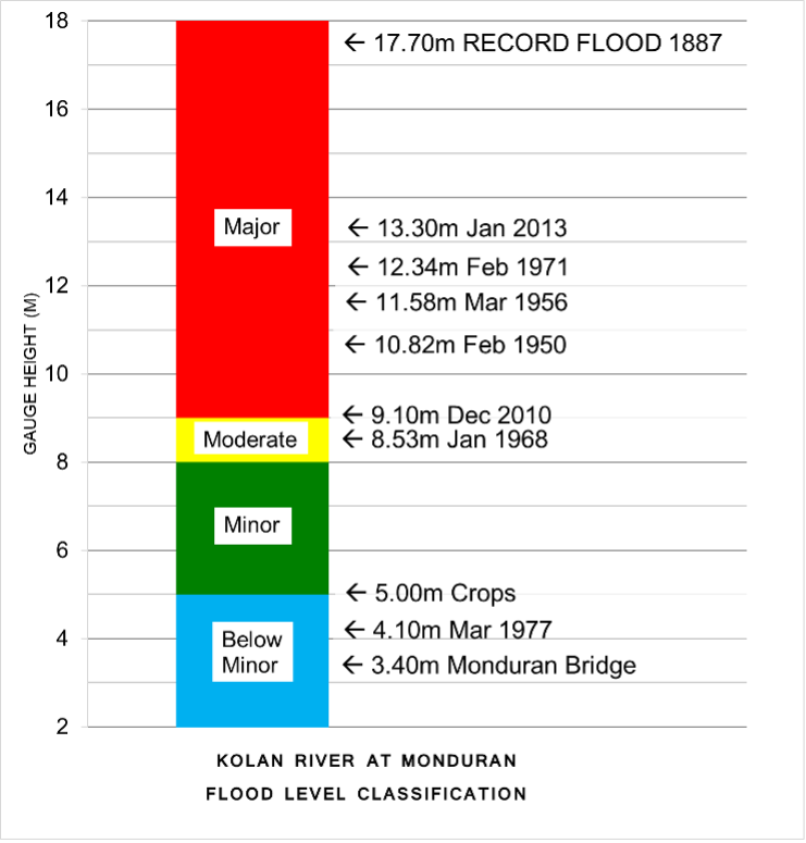
Fred Haigh Dam was completed in 1974, with only minor to moderate flooding being recorded between this time and December 2010. In January 2013 the dam spilled by 6.85 metres causing widespread major flooding downstream.
The main impacts of flooding on the Kolan River and Gin Gin Creek are the disruption of transport routes, in major floods this can include the Bruce Highway and North Coast Rail Line, as well as isolation of property. In major floods inundation of residential properties can occur. Flash flooding can occur at Agnes Water, Lowmead, Miriam Vale, Rosedale, Colonial Cove (Baffle Creek), Leixlip Creek (Calliope), upstream of Awoonga Dam, Gladstone, and Gin Gin.
The Baffle Creek catchment area drains an area of approximately 4000 square kilometres, and lies to the immediate north of the Kolan River catchment. The creek arises near Miriam Vale, flowing in a generally southeast direction, and is joined by tributaries Colosseum Creek and Granite Creek upstream of Lowmead and Mimvale. The river turns to the northeast after passing through Essendean Bridge (Tablelands Road). Flooding on Baffle Creek primarily impacts transport routes through the region, with limited known impacts on property from flooding.
Previous Flooding
Previous flood information for the Kolan River is well documented. Monduran has manually observed peak heights dating back to 1887, with Molangool (upstream of Fred Haigh Dam) dating back to 1967. More recently an automatic gauge has been installed at Springfield, just downstream of Molangool and now forms the primary flood intelligence for the area.
Record major flooding was recorded in the Kolan River at Bucca Weir in January 2013 (Tropical Cyclone Oswald). Major flooding was also recorded along the Kolan River in March/April and October 2017 (Tropical Cyclone Debbie).
In March 2026, the remnants of tropical low 29U combined with a trough moving across the south of the state and brought widespread heavy rainfall to locally intense rainfall to parts of central Queensland. Widespread accumulated rainfall totals of 100 to 250 mm were recorded between Saturday 7 and Tuesday 10 March, with isolated higher totals. This led to significant flash flooding throughout Gladstone and Agnes Waters, as well as major riverine flooding in parts.
Previous flooding events
| Flood Event | Monduran | Molangool* | Bucca | Essendean Bridge |
| 1887 | 17.70** | – | – | – |
| December 1973 | – | 9.53 | – | – |
| March 1992 | 3.90 | 10.30 | 20.95 | – |
| December 2010 | 9.10 | – | 18.73 | – |
| March 2012 | 5.00 | – | 19.64 | – |
| January 2013 | 13.30 | – | 23.84 | 18.10 |
| March 2017 | – | 9.66 | 19.61 | – |
| October 2017 | – | 11.06 | 20.06 | – |
| March 2026 | – | 10.09 | 18.22 | 11.07 |
All heights are in metres on flood gauges.
*Molangool data after 2013 is sourced from the nearby Springfield gauge and may not be directly comparable with data before then.
**Height taken from a flood mark rather than a manual observation.


Further Information:
- Latest rainfall and river heights
- Flood warning service for the Kolan River and Baffle Creek: Queensland Service Level Specification
- Catchment map: Baffle, Boyne, Kolan and Calliope catchment map
- National Arrangements for Flood Forecasting and Warning