


Names and code spaces in WDTF
| Gavin Walker, Simon Cox | 2 December 2008 | Gavin.Walker@csiro.au |
This document covers the use of Universal Resource Identifiers (URIs) as names and code spaces in the Water Data Transfer Format (WDTF).
WDTF URI scheme
A scheme for identifying features and other objects that appear in WDTF documents has been defined, with the following format

- URI scheme owner: The owner of the URI scheme and its resolution mechanism. This URI will be resolved by http when a service is deployed at this address. The scheme owner is www.bom.gov.au/std/water/xml/wio0.2. It is the authority for the definition of the rest of the URI. A change is this part indicates the structure or the meaning of the remaining parts has changed.
- Class: (definition|classifier|feature|party|procedure|property| ... more ...) the general class of object being
identified.
- definition: a definition, concept or type
- classifier: a concept that links to semantics
- feature: an instance
- party: a person, company, or other responsible entity
- procedure: the process by which a property is measure
- property: a property (or parameter) of a feature
- more classes may be defined later
- ObjectType: (optional) indicates the type of object this is being identified. In this example it is the SamplingPoint (or location). The object name may also be used as the XML element tag for the object in WDTF
- Authority: indicates the authority for the identifier. In most cases the this will be the agency id as agencies are responsible for the identifiers of most objects in WDTF.
- Identifier: The identifier of the object as specified by the authority. It must refer to a unique resource in the context of the rest of the URI. These are opaque to users except for the authority who created the identifier. The authority should have a rule, for example that a composite identifier be built by joining fragments together with a /. In the example above the SamplingPoint (or location) has an id (1) in the agency (w00001) relative to the SamplingGroup (or site) id (410729). So a unique id for the SamplingPoint (or location) becomes 410729/1 by joining the fragments with a /. If, on the other hand, the agency (w00001) had a unique id for SamplingPoint (or location) such as 4111 which was independent of SamplingGroup (or site) then that could have been used. Those agencies currently transmitted flood data through HCS have special rules.
Identifiers for spatial reference systems
Spatial reference systems used in WDTF shall use the identifier schema defined by OGC. This is a URN scheme with the following pattern:
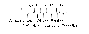
- Scheme: The URI type and owner.
- Class: This URI is defining something. The def is currently the only value value.
- ObjectType: Declares the type of object being defined. WDTF is concerned about
- cs: Coordinate system.
- crs: Coordinate reference system.
- datum: Reference datum.
- Authority: The authority for the particular identifier. Only two values are allowed
in WDTF
- EPSG: For EPSG defined codes. See http://www.epsg-registry.org/
- bom: For Bureau of Meteorology defined codes. These cover datums and engineering coordinate systems.
- Version: An optional version number may be provided if the object specified by the id changes. For example if EPSG revises their definition of 5111 (AHD Mainland) a version number can be used to identify which one.
- Identifier: The identifier for the object. EPSG uses numbers. The Bureau of Meteorology uses text.
For a general discussion of OGC URIs see http://www.oostethys.org/development/best-practices/best-practices-ogc-urns/
The Spatial Refernece System URIs can be combined. For example
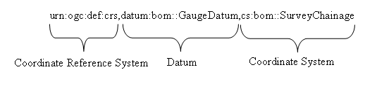
combines the Bureau defined survey engineering coordinate system (which defines horizontal and vertical offset, in metres, relative to a point) with the Bureau defined gauge datum (the height of the gauge) to fix the engineering coordinate system relative to a fixed height. For a general discussion on vertical datums and combining coordinate systems see http://www.oostethys.org/development/best-practices/Vertical Datums/ and Definition identifier URNs in OGC namespace (07-092r1) v. 1.1.2 .
Unknown values
Where the identity of a referent is unknown, as is often the case with procedures, a URI designating a nil value may be used. The OGC URN for nil values has the form
urn:ogc:def:nil:OGC::unknown
The OGC URN scheme identifies five kinds of nil:
- inapplicable - The object does not have a value
- missing - The correct value is not readily available to the sender of this data. Furthermore, a correct value may not exist.
- template - The value will be available later
- unknown - The correct value is not known to, and not computable by, the sender of this data. However, a correct value probably exists.
- withheld - The value is not divulged
Objects and properties
General implementation of properties
WDTF follows the ISO and OGC standards in using two types of XML element to encode a schema derived from UML modelling: objects and properties. Objects are complex elements that may contain many properties. Properties are elements than may contain only one value (but many attributes). That value may be
- A simple type like a string, number or XMLSchema list.
- An object.
- No value but includes a reference refering to an object. The reference is implemented as a hyperlink, using the xlink:href attribute.
A reference can have two forms, either
- a full URI referring to the object's name, or
- a local reference to an object in the same document
<wdtf:SamplingPoint gml:id="l1">
    <gml:name
	codeSpace="http://www.bom.gov.au/std/water/xml/wio0.2/feature/SamplingPoint/w00001/">410729/1</gml:name>
...
</wdtf:SamplingPoint>
The feature of interest property of say a time series observation object could refer to the sampling point objects as
<om:featureOfInterest xlink:href="#l1"/>
if it were in the same document or as
<om:featureOfInterest xlink:href="http://www.bom.gov.au/std/water/xml/wio0.2/feature/SamplingPoint/w00001/410729/1"/>
if the sampling point (or location) was in a separate document.
The top level object in WDTF is called HydroCollection. It has eight main properties metadata, definitionMember, transactionMember, siteMember, specimenMember, observationMember, featureMember and conversionMember.
metadata
Metadata about the entire HydroCollection document belongs here. Most other major objects also have metadata members.
definitionMember
Here complex relationships between properties (or parameters) are defined. In particular the property (or parameter) pairings used in conversions (or gaugings) are placed here.
transactionMember
Tranaction member contains a SynchronisationTransaction which defines the time bounds for the supplied data. This is used to update the appropriate records at the Bureau, allowing deletions as well as additions.
siteMember
The siteMember allows the choice of a SamplingGroup (or site) or a SamplingPoint (or location). The terminology here comes from the observations and measurements model. They are examples of imported schema fragments customized to the WDTF application. It is useful to think of a SamplingGroup (or site) as a place one can drive to and then walk to a SamplingPoint (or location). The SamplingPoint (or location) is typically the tower the sensors hang off. The SamplingGroup (or site) is a spatially cohesive set of SamplingPoints (or locations). Every SamplingPoint (or location) is required to have a SamplingGroup (or site) and vice versa.
specimenMember
The specimenMember contains water sample information as both samples and bottles (or fragments) of samples. Each Specimen has a relatedSamplingFeature which points to the SamplingPoint (or location) where the water was taken. Specimens are closely tied to Measurements which are the observations on the specimen.
observationMember
The observationMember allows a choice of all the different types of observations: Measurement, ComplexObservation, TimeSeriesObservation and GeometryObservation. The observation objects embody the observations and measurements model.
- Measurement: Observations of specimens.
- ComplexObservation: Observations of gaugings for conversions. They are able to represent measurements of multiple properties (or parameters) at the same time.
- TimeSeriesObservation: Observations of single properties (or parameters) over time. This includes observations related to flood forecasted that used to be encoded in HCS format.
- GeometryObservation: Surveys of storages and water courses. They relate directly to featureMembers.
featureMember
The featureMember contains information about water courses and storages. These are the sampledFeatures refered to in the time series. Only a very small amount of information is covered. These will be replaced will full definitions from the Australian Hydrological GeoFabric (AHGF) when it is developed. While these objects are not mandatory, if this information is available it helps tie the water quality and quantity information to the river network.
conversionMember
The featureMember contains information about conversion tables and the DurationGroups which apply those tables in sequence.
Names
Almost all objects in WDTF use a <gml:name> tag. The name refers to the persistent identity of the object (as opposed to the gml:id which give an identity only in the file). More than one object in the same document or across documents may have the same name. This is allows objects that belong together to be grouped together. For example two time series observation objects in different documents may have the same name, say
http://www.bom.gov.au/std/water/xml/wio0.2/feature/TimeSeriesObservation/w00001/410729/1/WaterCourseLevel/1
This means that both those time series objects are fragments of the same time series. An object may have multiple names which would allow it to be part of multiple persistent identities for different purposes, however at this stage all WDTF objects have only one name.
In the complex observation (or gauging) objects the name is used to group related gaugings together. That is all gaugings for the same artefact, such as a weir, and measuring the same thing, such as level and flow, under the same conditions have the same name.
Code spaces
Names and a few other elements have a code space attribute. This is a qualifier for the value of the name. It says that the meaning of the name can be found by looking up a dictionary or asking the authority defined by the code space. In WDTF the codespace is made up of the object's URI minus the identifier. For example the code space of sampling point
http://www.bom.gov.au/std/water/xml/wio0.2/feature/SamplingPoint/w00001/410729/1
is
http://www.bom.gov.au/std/water/xml/wio0.2/feature/SamplingPoint/w00001/
The exception to this rule is the time series observation name. In this case the name value is required to be an integer so the code space becomes everything in the URI except the last integer. For example with time series observation URI
http://www.bom.gov.au/std/water/xml/wio0.2/feature/TimeSeriesObservation/w00001/410729/1/WaterCourseLevel/1
the code space it
http://www.bom.gov.au/std/water/xml/wio0.2/feature/TimeSeriesObservation/w00001/410729/1/WaterCourseLevel/
Name values
The values of names (and the values of other elements with code spaces) are the identifiers of URIs and are meant to be opaque to all except the authority that created them. It is the responsibility of the authority to create the identifiers so that the URIs refer uniquely to the required object. An authority may do this by either assigning a unique id or by creating a unique id by combining relative identifiers (or primary key parts in database terms). In WDTF it is recomended that this combination be made by joining parts with forward slash "/". See WDTF URI scheme for an example.
Those data providers that also send flood data to the Bureau in the HCS format must adhere to the HCS rules for identifiers. The other exception is in the time series observation where the name value must be an integer and represents an instance number. The instance number distinguishes between different streams of data such as:
- Telemetered data
- Data extracted directly from the logger
- Data from different sensors measuring exactly the same thing at the same sampling point (or location).
In this case the rest of the identifier required to separate data streams across sampling points (or locations) and properties (or parameters) are included in the code space. See the example under code spaces.
Creating URIs from code spaces and name values
In WDTF a URI can be created from a name value and code space by simply adding the name value string to the code space string.
HCS users
Data providers that currently send data to the Bureau in HCS format for flood forecasting need to use WDTF in a special way. HCS and WDTF data will be transmitted in parallel for some time and some of the URIs in WDTF need to be consistent with HCS data. In the HCS format the SiteId has type SR, SSR or SLSR which correspond to Site, Site-Sensor and Site-Location-Sensor respectively. In WDTF the site corresponds to a sampling group, the location a sampling point and the sensor a procedure, however in HCS the identifiers are relative whereas in WDTF they are absolute. Also in HCS the location is not always provided whereas in WDTF the sampling point (or location) is mandatory. In this case the data provider should assign the site a location. A relative id of 1 is recommended.
When a time series observation created by a data provider who also sends the equivalent data via HCS the following rules for identifiers must be obeyed.
- The feature of interest element (which represents the sampling point (or location)) should have an identifier constructed by joining the site id and the location id with a "/". For example with SLSR 410729-1-1 the sampling point identifier is 410729/1.
- The related sampling feature element (which represent the sampling group (or site)) will have the normal site identifier. For example with SLSR 410729-1-1 the sampling group identifier is 410729.
- The procedure element (which represents the HCS sensor) needs an identifier qualified by the sampling group (or site) and sampling point (or location). For example with SLSR 410729-1-1 the procedure identifier is 410729/1/1.
Of course these elements use full URIs not just the authority's identifier so the code space should be prepended to the identifiers above. If the site type is SR and no sensor information is present then "urn:ogc:nil:OGC::unknown" should be used for the procedure (see unknown values).