State of the Climate 2014

About the State of the Climate report

Weather and climate touch all aspects of Australian life. What we experience here at home is part of the global climate system. The Bureau of Meteorology and CSIRO contribute significantly to the international effort of weather and climate monitoring, forecasting and research. In State of the Climate, we discuss the long-term trends in Australia’s climate.

This is our third biennial State of the Climate report. As with our earlier reports, we focus primarily on climate observations and monitoring carried out by the Bureau of Meteorology and CSIRO in the Australian region, as well as on future climate scenarios.

Timeline showing where the Bureau of Meteorology and CSIRO data does comes from

State of the Climate 2014 draws on an extensive record of observations and analysis from CSIRO, the Bureau of Meteorology, and other sources.

Report at a glance

Data and analysis from the Bureau of Meteorology and CSIRO show further warming of the atmosphere and oceans in the Australian region, as is happening globally. This change is occurring against the background of high climate variability, but the signal is clear.

Air and ocean temperatures across Australia are now, on average, almost a degree Celsius warmer than they were in 1910, with most of the warming occurring since 1950. This warming has seen Australia experiencing more warm weather and extreme heat, and fewer cool extremes. There has been an increase in extreme fire weather, and a longer fire season, across large parts of Australia.

Rainfall averaged across all of Australia has slightly increased since 1900. Since 1970, there have been large increases in annual rainfall in the northwest and decreases in the southwest. Autumn and early winter rainfall has mostly been below average in the southeast since 1990.

Atmospheric greenhouse gas concentrations continue to rise and continued emissions will cause further warming over this century. Limiting the magnitude of future climate change requires large and sustained net global reductions in greenhouse gases.

KEY POINTS

  • Australia’s climate has warmed by 0.9°C since 1910, and the frequency of extreme weather has changed, with more extreme heat and fewer cool extremes.
  • Rainfall averaged across Australia has slightly increased since 1900, with the largest increases in the northwest since 1970.
  • Rainfall has declined since 1970 in the southwest, dominated by reduced winter rainfall. Autumn and early winter rainfall has mostly been below average in the southeast since 1990.
  • Extreme fire weather has increased, and the fire season has lengthened, across large parts of Australia since the 1970s.
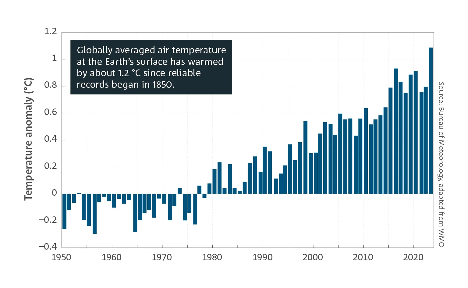
  • Global mean temperature has risen by 0.85°C from 1880 to 2012.
  • The amount of heat stored in the global oceans has increased, and global mean sea level has risen by 225 mm from 1880 to 2012.
  • Annual average global atmospheric carbon dioxide concentrations reached 395 parts per million (ppm) in 2013 and concentrations of the other major greenhouse gases are at their highest levels for at least 800 000 years.
  • Australian temperatures are projected to continue to increase, with more extremely hot days and fewer extremely cool days.
  • Average rainfall in southern Australia is projected to decrease, and heavy rainfall is projected to increase over most parts of Australia.
  • Sea-level rise and ocean acidification are projected to continue.

Australia’s climate

Temperature

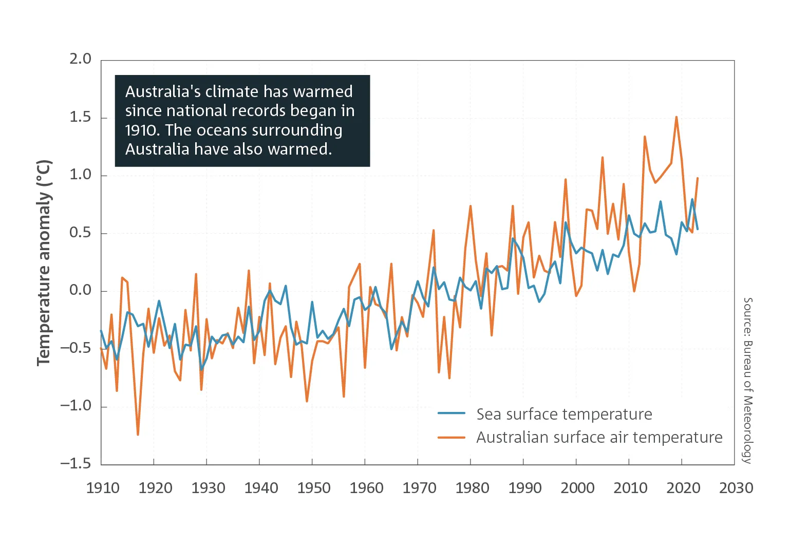
Australia’s climate has warmed since national records began in 1910, especially since 1950. Mean surface air temperature has warmed by 0.9°C since 1910. Daytime maximum temperatures have warmed by 0.8°C over the same period, while overnight minimum temperatures have warmed by 1.1°C. The warming trend occurs against a background of year-to-year climate variability, mostly associated with El Niño and La Niña in the tropical Pacific. 2013 was Australia’s warmest year on record, being 1.2°C above the 1961–1990 average of 21.8°C and 0.17°C above the previous warmest year in 2005. Seven of the ten warmest years on record have occurred since 1998.

Sea-surface temperatures in the Australian region have warmed by 0.9°C since 1900. In 2013, temperatures were 0.5°C above the 1961–1990 average of 22.3°C. Sea-surface temperatures around parts of Australia have been mostly well-above average since 2010, with persistent regions of very warm to highest-on-record temperatures to the south and west of the continent throughout much of 2013.

Map of Australia with orange and red colours throughout indicating annual mean temperature increases since 1910

Annual mean temperature changes across Australia since 1910.

Since 2001, the number of extreme heat records in Australia has outnumbered extreme cool records by almost 3 to 1 for daytime maximum temperatures, and almost 5 to 1 for night-time minimum temperatures.

Very warm months that occurred just over 2 per cent of the time during the period 1951 to 1980 occurred nearly 7 per cent of the time during 1981 to 2010, and around 10 per cent of the time over the past 15 years. At the same time the frequency of very cool months has declined by around a third since the earlier period.

Graph showing increasing temperature anomalies of sea-surface and surface air temperature since 1910

Time series of anomalies in sea-surface temperature and temperature over land in the Australian region. Anomalies are the departures from the 1961–1990 average climatological period. Sea-surface temperature values are provided for a region around Australia (from 4°S to 46°S and from 94°E to 174°E).

Two bell curves showing the change in distribution of monthly maximum and minimum temperatures

Distribution of monthly maximum temperature (left) and monthly minimum temperature (right), expressed as anomalies (standardised), aggregated across 104 locations and all months of the year, for three periods: 1951–1980 (pink, grey), 1981–2010 (orange, green) and 1999–2013 (red, blue). Means and standard deviations used in the calculation of the standardised anomalies are with respect to the 1951–1980 base period in each case. Very warm and very cool months correspond to two standard deviations or more from the mean. The vertical axis shows how often temperature anomalies of various sizes have occurred in the indicated periods.

KEY POINTS

  • Australia’s mean surface air temperature has warmed by 0.9°C since 1910.
  • Seven of the ten warmest years on record have occurred since 1998.
  • Over the past 15 years, the frequency of very warm months has increased five-fold and the frequency of very cool months has declined by around a third, compared to 1951–1980.
  • Sea-surface temperatures in the Australian region have warmed by 0.9°C since 1900.

Rainfall

Australian rainfall is highly variable, which makes it difficult to identify significant trends over time, nevertheless some rainfall changes are discernible.

Australian average annual rainfall has increased since national records began in 1900, largely due to increases in rainfall from October to April, and most markedly across the northwest.

Southern Australia typically receives most of its rainfall during the cooler months of the year. In recent decades declines in rainfall have been observed in the southwest and in the southeast of the continent.

Since 1970 there has been a 17 per cent decline in average winter rainfall in the southwest of Australia. The southeast has experienced a 15 per cent decline in late autumn and early winter rainfall since the mid-1990s, with a 25 per cent reduction in average rainfall across April and May. Declining rainfall in the southwest has been statistically significant over the recent period, and has occurred as a series of step changes. The decline in this region has also been characterised by a lack of very wet winters.

The cool season drying over southern Australia in recent decades, and evidence of increased rainfall over the Southern Ocean, is associated with changes in atmospheric circulation. While natural variability likely plays a role, a range of studies suggest ozone depletion and global warming are contributing to circulation and pressure changes, most clearly impacting on the southwest. Uncertainties remain, and this is an area of ongoing research.

The reduction in rainfall is amplified in streamflow in our rivers and streams. In the far southwest, streamflow has declined by more than 50 per cent since the mid-1970s. In the far southeast, streamflow during the 1997–2009 Millennium Drought was around half the long-term average.

Map of Australia with colours showing northern wet season (October-April) rainfall deciles since 1995-96, with blue areas indicating an increase in rainfall in the north.

Northern wet season (October–April) rainfall deciles since 1995–96. A decile map shows the extent that rainfall is above average, average or below average for the specified period, in comparison with the entire national rainfall record from 1900. The northern wet season is defined as October to April by the Bureau of Meteorology.

Map of Australia with colours showing Southern wet season (April-November) rainfall deciles since 1996, with red areas indicating a drying trending the south.

Southern wet season (April–November) rainfall deciles since 1996. A decile map shows the extent that rainfall is above average, average or below average for the specified period, in comparison with the entire rainfall record from 1900. The southern wet season is defined as April to November by the Bureau of Meteorology.

KEY POINTS

  • Rainfall averaged across Australia has slightly increased since 1900, with a large increase in northwest Australia since 1970.
  • A declining trend in winter rainfall persists in southwest Australia.
  • Autumn and early winter rainfall has mostly been below average in the southeast since 1990.

Heatwaves and fire weather

The duration, frequency and intensity of heatwaves have increased across many parts of Australia, based on daily temperature records since 1950 when coverage is sufficient for heatwave analysis. Days where extreme heat is widespread across the continent have become more common in the past twenty years.

Some recent instances of extreme summer temperatures experienced around the world, including record-breaking summer temperatures in Australia over 2012–2013, are very unlikely to have been caused by natural variability alone.

Fire activity is sensitive to many different factors; the meteorological factors include wind speed, humidity, temperature and drought. Fire weather is monitored in Australia with the Forest Fire Danger Index (FFDI). Annual cumulative FFDI, which represents the occurrence and severity of daily fire weather across the year, increased with statistical significance at 16 of 38 climate reference sites from 1973–2010, with non-statistically significant increases at the other sites. Extreme fire-weather days have become more extreme at 24 of the 38 locations since the 1970s.

Graph showing an increase in the number of days each year where Australian area-averaged daily mean temperature are in the warmest 1 per cent of records since 1910

Number of days each year where the Australian area-averaged daily mean temperature is above the 99th percentile for the period 1910–2013. The data are calculated from the number of days above the climatological 99th percentile for each month and then aggregated over the year. This metric reflects the spatial extent of extreme heat across the continent and its frequency. Half of these events have occurred in the past twenty years.

Maps of Australia with red dots showing increasing trends in extreme fire weather days, and an inset graph showing the increase in Melbourne

The map shows the trends in extreme fire weather days (annual 90th percentile of daily FFDI values) at 38 climate reference sites. Trends are given in FFDI points per decade and larger circles represent larger trends. Filled circles represent trends that are statistically significant. One location, Brisbane Airport, shows a non-significant decrease.

Time series showing the increasing trend in the annual cumulative Forest Fire Danger Index (FFDI) at Melbourne Airport. A long-term trend is discernible despite significant annual variability.

The number of significant increases is greatest in the southeast, while the largest increases in the index occurred inland rather than near the coast. The largest increases in seasonal FFDI occurred during spring and autumn, while summer had the fewest significant trends. This indicates a lengthened fire season.

Heavy rainfall

Natural variability continues to play the dominant role in extreme rainfall in Australia. Observational data show that the area of the continent receiving very high rainfall totals (above the 90th percentile) on seasonal and annual timescales has increased since the mid-twentieth century, however few statistically significant trends in changing rainfall intensity have been found across the continent.

Recent studies examining heavy monthly to seasonal rainfall events that occurred in eastern Australia between 2010 and 2012 have shown that the magnitude of extreme rainfall is mostly explained by natural variability, with potentially a small additional contribution from global warming. Understanding changes to Australian rainfall intensity is an area of ongoing research.

Tropical cyclones

It is difficult to draw conclusions regarding changes in the frequency and intensity of tropical cyclones in the Australian region because of the shortness of the satellite record, changes in historical methods of analysis, and the high variability in tropical cyclone numbers. The research on cyclone frequency in the Australian region is equivocal, with some studies suggesting no change and others a decrease in numbers since the 1970s.

KEY POINTS

  • The duration, frequency and intensity of heatwaves have increased across large parts of Australia since 1950.
  • There has been an increase in extreme fire weather, and a longer fire season, across large parts of Australia since the 1970s.

Global atmosphere and cryosphere

Warming in Australia is consistent with warming observed across the globe in recent decades. Evidence that the Earth’s climate continues to warm is unequivocal. Multiple lines of evidence indicate that it is extremely likely that the dominant cause of recent warming is human-induced greenhouse gas emissions and not natural climate variability.

Much of the observed warming has occurred since the 1950s. There has been warming at the Earth’s surface, warming in the lower and middle atmosphere (troposphere), warming of sea-surface temperatures and warming below the ocean surface. Global warming is also apparent from decreases in the mass of Greenland and Antarctic ice sheets (ice attached to land), net decrease in glacier volumes, large reductions in Arctic sea-ice extent, higher global sea level and reductions in snow cover.

The instrumental record shows that global mean temperature has risen by 0.85°C (± 0.2°C) since 1880. All of the warmest 20 years on record have occurred since 1990.

Ice-mass loss from Antarctic and Greenland ice sheets has accelerated. The mean estimated rate of ice loss from the Antarctic ice sheet has increased nearly five-fold from an estimated mean of 30 gigatonnes per year (Gt/yr) for the period from 1992 to 2001, to 147 Gt/yr for the period 2002 to 2011. The rate of ice loss from the Greenland ice sheet has increased from 34 to 215 Gt/yr over the same period.

The average rate of ice loss from glaciers around the world, excluding glaciers on the periphery of the ice sheets, was very likely 226 Gt/yr over the period 1971 to 2009, and very likely 275 Gt/yr over the period 1993 to 2009.

Arctic summer minimum sea-ice extent has declined by between 9.4 and 13.6 per cent per decade since 1979, a rate that is likely unprecedented in at least the past 1,450 years.

Antarctic annual-mean total sea-ice extent has slightly increased by 1.2 per cent to 1.8 per cent per decade since 1979. This net increase represents the sum of contrasting regional trends around Antarctica.

The overall increase in Antarctic sea-ice extent has been linked to several possible drivers, including freshening of surface waters due to increased precipitation and the enhanced melting of ice shelves, and changes in atmospheric circulation resulting in greater sea-ice dispersion.

Landscape schematic indicating changes in the global climate system

Indicators of a world experiencing a consistent pattern of warming.

1With regional variation (almost all glaciers worldwide losing mass but some gaining) but overall net loss.

2With regional variation (large loss in the Arctic, small net gain in the Antarctic) but overall net loss.

KEY POINTS

  • A wide range of observations show that the global climate system continues to warm.
  • It is extremely likely that the dominant cause of recent warming is human-induced greenhouse gas emissions and not natural climate variability.
  • Ice-mass loss from the Antarctic and Greenland ice sheets has accelerated over the past two decades.
  • Arctic summer minimum sea-ice extent has declined by between 9.4 and 13.6 per cent per decade since 1979, a rate that is likely unprecedented in at least the past 1,450 years.
  • Antarctic sea-ice extent has slightly increased by between 1.2 per cent and 1.8 per cent per decade since 1979.

Oceans

Ocean heat content

Warming of the world’s oceans accounts for more than 90 per cent of additional energy accumulated from the enhanced greenhouse effect, making this one of the most important measures for monitoring and understanding climate change.

The ocean today is warmer, and sea levels higher, than at any time since the instrumental record began.

Ocean heat content is a key indicator of heat accumulated in the oceans, and is measured in units of energy known as joules. The upper layer of the ocean, from the surface to a depth of 700 metres, has increased its heat content by around 17x1022 joules since 1971, accounting for around 63 per cent of additional energy accumulated by the climate system. Warming below 700metres over the same period accounts for approximately 30 per cent of additional energy. The remaining 7 per cent has been added to the cryosphere, atmosphere and land surface.

Graph showing increasing trend in ocean heat content since 1960

Change in ocean heat content (in joules) from the full ocean depth, from 1960 to present. Shading provides an indication of the confidence range of the estimate.

Sea level

Global mean sea level has increased throughout the 20th century. By 2012 sea level was 225 mm (± 30 mm) higher than in 1880, the earliest year for which robust estimates are available.

The largest contributions to global sea-level rise have been thermal expansion of the oceans (expansion through warming) and the loss of mass from glaciers and ice sheets.

Rates of sea-level rise vary around the Australian region, with higher sea-level rise observed in the north and rates similar to the global average observed in the south and east. Global sea level fell during the intense La Niña event of 2010–2011. This was ascribed partly to the exceptionally high rainfall over land which resulted in floods in Australia, northern South America, and Southeast Asia. This was compounded by the long residence time of water over inland Australia. Recent observations show that sea levels have rebounded in line with the long-term trend.

Ocean acidification

Ocean acidification is caused by the ocean absorbing higher levels of carbon dioxide (CO2) from the atmosphere, and is therefore another consequence of the accumulation of anthropogenic CO2 in the Earth’s climate system. Ocean acidity is measured in units of ‘pH’. A lowering pH means increasing acidity. The pH of surface waters in the open ocean has decreased by about 0.1 since 1750, equivalent to a 26 per cent increase in the activity of hydrogen ions (a measure of ocean acidity).

Graph showing increasing trend in sea level since 1880, with inset showing more details since 1993

High-quality global sea-level measurements from satellite altimetry since the start of 1993 (orange line), in addition to the longer-term records from tide gauges (green line, with shading providing an indication of the confidence range of the estimate).

Inset: Sea-level increase since 1993 from the satellite altimetry. The light green line shows the monthly data, the dark green line the three-month moving average, and the orange line the linear trend.

KEY POINTS

  • The Earth is gaining heat, most of which is going into the oceans.
  • Global-mean sea level (GMSL) increased throughout the 20th century and in 2012 was 225 mm higher than in 1880.
  • Since 1993, the rates of sea-level rise to the north and northwest of Australia have been two to three times the global average.
  • Ocean acidity has increased by about 26 per cent since the 1800s due to absorption of higher CO2 concentrations from the atmosphere.

Greenhouse gases

Carbon dioxide emissions

Global anthropogenic CO2 emissions into the atmosphere in 2013 are estimated to be 38.8 billion tonnes of CO2 (10.6 billion tonnes of carbon), the highest in history and about 46 per cent higher than in 1990. Global CO2 emissions from the use of fossil fuel are estimated to have increased in 2013 by 2.1 per cent compared with the average of 3.1 per cent per year from 2000 to 2012.

Since the industrial revolution more than two centuries ago, about 30 per cent of the anthropogenic CO2 emissions have been taken up by the ocean and about 30 per cent by land vegetation. The remaining 40 per cent of emissions have led to an increase in the concentration of CO2 in the atmosphere.

The origin of CO2 in the atmosphere can be determined by examining the different types (isotopes) of carbon in air samples. This identifies the additional CO2 as coming from human activities, mainly the burning of fossil fuel, and not from natural sources.

Three graphics showing changes in carbon dioxide emissions, including increasing emission and uptake since 1840 and the reduce in the carbon-13 isotope since the year 1000

Most of the CO2 emissions from human activities are from fossil-fuel combustion and land-use change (top graph). Emissions are expressed in gigatonnes of carbon (C) per year. A gigatonne is equal to 1 billion tonnes. One tonne of carbon (C) equals 3.67 tonnes of carbon dioxide (CO2). CO2 emissions from human activities have been taken up by the ocean (middle graph, in blue, where negative values are uptake), by land vegetation (middle graph, in gold), or remain in the atmosphere. There has been an increase in the atmospheric concentration of CO2 (bottom graph, in red), as identified by the trend in the ratio of different types (isotopes) of carbon in atmospheric CO2 (bottom graph, in black, from the year 1000). CO2 and the carbon-13 isotope ratio in CO213C) are measured from air in Antarctic ice and firn (compacted snow) samples from the Australian Antarctic Science Program, and at Cape Grim (northwest Tasmania).

Greenhouse gas concentrations

Atmospheric concentrations of major greenhouse gases, including CO2, methane (CH4), nitrous oxide (N2O), and a group of synthetic greenhouse gases, are increasing.

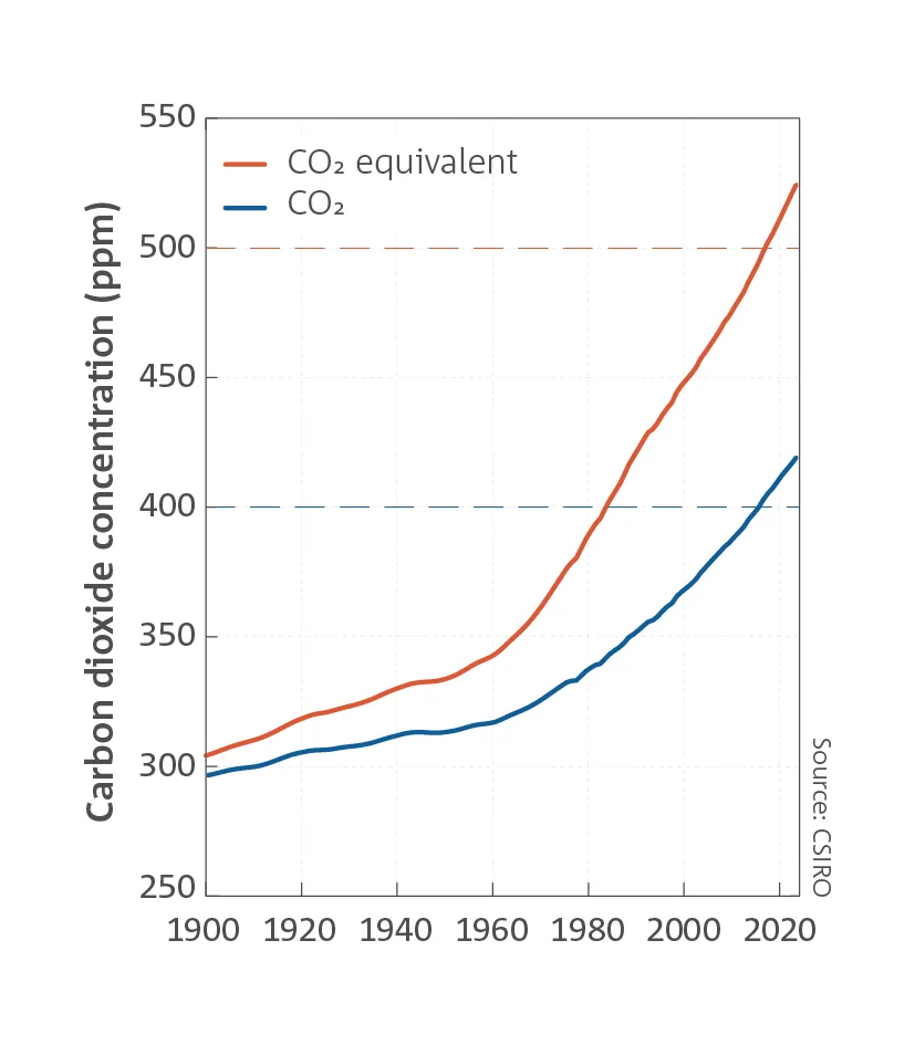
Atmospheric greenhouse gas levels have exceeded the record levels reported in the State of the Climate 2012 report, continuing the increase observed over the past century. The global mean CO2 level in 2013 was 395 parts per million (ppm) — a 43 per cent increase from pre-industrial (1750) concentrations, and likely the highest level in at least 2 million years.

The global CO2 annual increase from 2012 to 2013 was 2.5 ppm, and the increase of 5.1 ppm since 2011 is the largest two-year increase observed in the historical record. Global atmospheric CH4 concentration is 151 per cent higher, and N2O 21 per cent higher than in 1750, and they are at their highest levels for at least 800 000 years.

The impact of all greenhouse gases in the atmosphere combined can be expressed as an ‘equivalent CO2’ atmospheric concentration, which reached 480 ppm in 2013.

Graph showing the increasing trend in various greenhouse gas concentrations since 1975

Global mean greenhouse gas concentrations (‘ppm’ is parts per million, while ‘ppb’ is parts per billion) determined from continuous monitoring by CSIRO, the Bureau of Meteorology and the CSIRO/Advanced Global Atmospheric Gases Experiment at Cape Grim since 1976, in Antarctic firn air samples since the mid-1970s, and globally by CSIRO since the mid-1980s.

KEY POINTS

  • Greenhouse gas concentrations continue to increase due to emissions from human activities.
  • Annual average global mean CO2 levels reached 395 ppm in 2013, the highest level in at least 2 million years, and levels of the other major greenhouse gases are the highest for at least 800,000 years.
  • The CO2 increase from 2011 to 2013 is the largest two-year increase ever observed in the CSIRO record.

Future climate scenarios for Australia

Australian temperatures are projected to continue to warm, rising by 0.6 to 1.5°C by 2030 compared with the climate of 1980 to 1999; noting that 1910 to 1990 warmed by 0.6°C. Warming by 2070, compared to 1980 to 1999, is projected to be 1.0 to 2.5°C for low greenhouse gas emissions and 2.2 to 5.0°C for high emissions. The high-emissions scenario assumes a continuation into the future of the global CO2 emissions growth seen over the past decade, whereas the low-emissions scenario assumes a significant reduction in global emissions over the coming decades. These projected changes in temperature will be felt through an increase in the number of hot days and warm nights and a decline in cool days and cold nights.

Further decreases in average rainfall are expected over southern Australia compared with the climate of 1980 to 1999: a zero to 20 per cent decrease by 2070 for low emissions; and a 30 per cent decrease to 5 per cent increase by 2070 for high emissions, with largest decreases in winter and spring. For northern Australia the projected changes in rainfall range from a 20 per cent decrease to 10 per cent increase by 2070 for low emissions, and a 30 per cent decrease to 20 per cent increase for high emissions. Droughts are expected to become more frequent and severe in southern Australia.

An increase in the number and intensity of extreme rainfall events is projected for most regions.

The number of extreme fire-weather days is projected to grow in southern and eastern Australia; by 10 to 50 per cent for low emissions and 100 to 300 per cent for high emissions, by 2050 compared with the climate of 1980 to 1999.

Fewer tropical cyclones are projected for the Australian region, on average, with an increased proportion of intense cyclones. However, confidence in tropical cyclone projections is low.

Sea-level rise around the Australian coastline by 2100 is likely to be similar to the projected global rise of 0.28 to 0.61 metres for low emissions and 0.52 to 0.98 metres for high emissions, relative to 1986–2005. Higher sea levels by 2100 are possible if there is a collapse of sectors of the Antarctic ice sheet grounded below sea level. There is medium confidence that such an additional rise would not exceed several tenths of a metre by 2100. Under all scenarios, sea level will continue to rise after 2100, with high emissions leading to a sea-level rise of 1 metre to more than 3 metres by 2300. Increases in mean sea level will increase the frequency of extreme sea-level events.

Ocean-acidity levels will continue to increase as the ocean absorbs anthropogenic carbon-dioxide emissions.

Reductions in global greenhouse gas emissions would increase the chance of constraining future global warming. Nonetheless adaptation is required because some warming and associated changes are unavoidable.

Map of Australia with tabs indicating future climate scenarios for Australia

Climate scenarios for Australia. Projections are based on our assessment of changes simulated by many climate models from around the world, including Australia.

KEY POINTS

  • Australian temperatures are projected to continue to increase, with more hot days and fewer cool days. 
  • A further increase in the number of extreme fire-weather days is expected in southern and eastern Australia, with a longer fire season in these regions. 
  • Average rainfall in southern Australia is projected to decrease, with a likely increase in drought frequency and severity. 
  • The frequency and intensity of extreme daily rainfall is projected to increase. 
  • Tropical cyclones are projected to decrease in number but increase in intensity. 
  • Projected sea-level rise will increase the frequency of extreme sea-level events. 

About us

The Bureau of Meteorology and CSIRO play a key role in monitoring, measuring, understanding and reporting on weather and climate phenomena.

The Bureau of Meteorology’s monitoring program tracks changes across Australia for a range of important climate indicators. The Bureau maintains nearly 800 temperature recording sites and collates data from more than 6000 rain gauges across the continent and in remote Australian territories.

CSIRO is a provider of research-observing facilities through national research infrastructure programs. These include Australia’s Terrestrial Ecosystem Research Network (TERN); the Integrated Marine Observing System (IMOS), which records and analyses changes in the marine environment at ocean-basin and regional scales covering physical, chemical and biological variables; and management of the Marine National Facility's research vessel Investigator.

CSIRO undertakes collaborative research in marine and atmospheric sciences as well as climate adaptation to support private- and public-sector planning, decision making and investment.

Through our research partnership, the Centre for Australian Weather and Climate Research, the Bureau of Meteorology and CSIRO collaboratively contribute to research that delivers critical research to underpin national benefit in areas such as weather prediction, hazard prediction and warnings, ocean prediction, climate variability and climate change, responses to weather and climate related health hazards, water supply and management, and adaptation to climate impacts.