
Flood Warning Infrastructure Network (FWIN) Program
We provide riverine flood forecasting and warning services across parts of Australia, using a network of more than 10,000 rain and river level gauges.
We own about one-third of these gauges. The rest are owned and maintained by local, state and territory governments, and private organisations.
In 2023, the Australian Government committed up to $236 million over 10 years to help the Bureau:
- simplify ownership
- upgrade and maintain about 1,600 priority sites currently owned by local and state governments.
We will also automate some of our manual sites.
Video: Flood warning infrastructure network program
Currently, there are more than 8,000 rain and river level gauge sites across Australia and the Bureau owns about one third of these gauges that it relies on to deliver flood forecasts and warnings.
Over the next 10 years the Bureau will acquire, upgrade and maintain around 1,600 additional flood warning sites located in high priority catchments across the country.
The work will lead to a modernised and well-maintained network that will enhance flood forecasts and warnings and improve community preparedness for flooding.
The national Flood Warning Infrastructure Network Program, known as FWIN, began in Queensland, where around 1,000 gauges will be upgraded by June 2029. The 10-year program will reach all states and territories. Upgrades will take place in a staggered approach over several years.
FWIN's acquisition of rain and river level gauge sites across the country is scheduled to be completed by June 2033.
Funded by the Australian Government, ongoing maintenance will be shared between the Bureau and state governments and reduce the financial burden on local councils to maintain flood warning sites.
Aims, benefits and process
Aims
The FWIN program aims to improve the long-term resilience of Australia's flood warning network.
Simplifying ownership and maintenance arrangements for the flood warning network helps ensure:
- national consistency
- data access
- quality control.
These changes assist communities to prepare for flood events.
Benefits
For communities and emergency management, benefits include improved:
- rain and river level observations
- data supporting flood forecasts and warnings
- support for disaster preparedness, response and recovery.
For current asset owners, it reduces the maintenance and improvement costs.
Process
The requirements to complete this work are complex, extensive and sometimes sensitive.
Program works are undertaken in a staged approach and are scheduled to be completed by 2033.
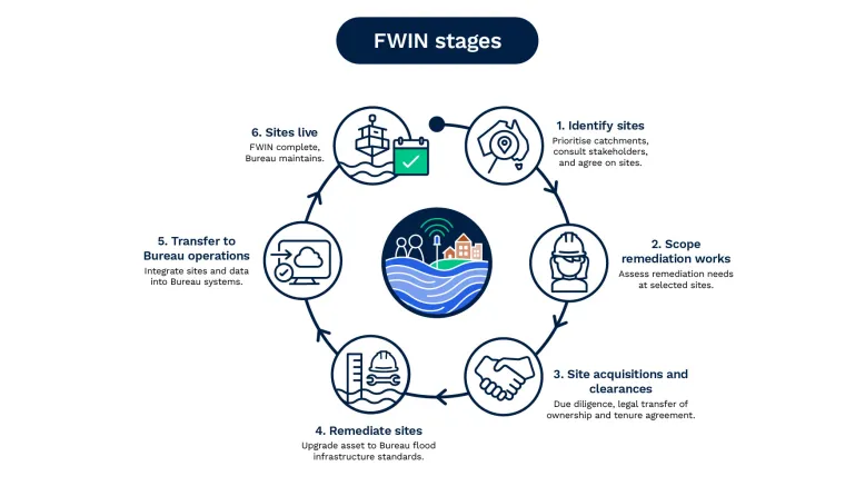
Stages of work for each of the 1,600 priority sites under the Flood Warning Infrastructure Network Program
Schedule and progress
Details of the schedule and progress for each state and territory.
Schedule
- Detailed planning: July 2023 to June 2024 – Completed.
- Site acquisition and upgrade work: from July 2024 – In progress.
- Site maintenance: from July 2025 – In progress.
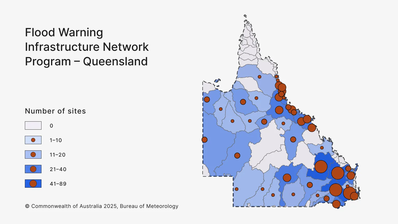
The full Queensland program:
- includes about 1,100 sites across 47 of the state's flood watch catchments
- involves 55 local government asset owners.
Progress
As of July 2026:
Stage 1 – Identify sites
Flood warning catchment priorities were agreed with state government partner, Queensland Reconstruction Authority (QRA) in 2024.
To identify priority flood gauge sites (listed below), we worked closely with:
- QRA
- Local Government Association Queensland
- local government asset owners.
We consulted with 62 local government asset owners through in-person workshops to understand local priorities and community needs.
In September 2024, the Bureau and Queensland asset owners initially agreed on more than 800 flood gauge sites to be included in the FWIN Program.
Consultation continues to identify the remaining flood gauge sites to be included.
Stage 2 – Scope remediation works
- Detailed technical assessments of flood gauge sites began in 2024.
- 715 site assessment reports have been completed in Queensland.
- Scope of works confirmed for 413 of these sites.
Stage 3 – Site acquisitions and clearances
Site acquisitions and clearances began in June 2024, with transfer of equipment agreements issued to local councils.
We have acquired 284 sites in Queensland. In addition, transfer of equipment agreements for:
- 41 sites are with councils for signing
- 46 sites await delegate approval.
Clearances are also in progress:
- 373 sites have had due diligence completed and a further 26 are in progress
- 299 sites have been cleared in accordance with the Native Title Act. A further 18 are in progress and another 36 require engagement with Traditional Owners
- 289 sites have been cleared for cultural heritage. A further 36 are in progress and another 30 require engagement with Traditional Owners
- 151 sites have tenure agreements completed, 208 sites are in progress and undergoing active negotiations
- 309 sites are undergoing environmental clearance.
Stage 4 – Remediate sites
- Remediation work began in Cairns in July 2024.
- 83 Queensland sites are under remediation. This includes preparing work packages, engaging vendors, and physical site works.
Stage 5 – Transition to Bureau operations
- Installation is complete at 28 Queensland sites. Acceptance testing and transition to Bureau operations are in progress.
Stage 6 – Sites live, routine maintenance
- First sites went live in December 2025.
- 14 Queensland sites display data on our website and are part of our regular maintenance schedule.

Sites in Queensland identified for acquisition
Queensland sites
These sites are in our program of works for Queensland. We will continue updating this list as more identified sites are confirmed. This list is current as of July 2026.
Banana Shire Council
- Dawson and Don Rivers, 47
- Mackenzie and Fitzroy Rivers and Shoalwater and Water Park Creeks, 1.
Barcaldine Regional Council
- Belyando and Suttor Rivers to Burdekin Falls Dam, 6.
Barcoo Shire Council
- Cooper Creek, 3
- Diamantina River, 2.
Boulia Shire Council
- Georgina River and Eyre Creek, 9.
Bulloo Shire Council
- Bulloo River, 2
- Cooper Creek, 2.
Bundaberg Regional Council
- Burnett River, 17
- Burrum and Cherwell Rivers, 5.
Burdekin Shire Council
- Belyando and Suttor Rivers to Burdekin Falls Dam, 2
- Burdekin River downstream of Burdekin Falls Dam, 19
- Burdekin River to Burdekin Falls Dam, 4
- Don and Proserpine Rivers, 2
- Haughton River, 13.
Bureau of Meteorology
- Multiple Flood Watch Catchments, 21.
Burke Shire Council
- Leichhardt River, 1
- Nicholson River, 12.
Cairns Regional Council
- Barron River, 19
- Mulgrave and Russell Rivers, 7.
Carpentaria Shire Council
- Cloncurry River, 1
- Leichhardt River, 1
- Lower Flinders River, 2
- Norman River, 15.
Cassowary Coast Regional Council
- Barron River, 1
- Johnstone River, 22
- Murray River, 6
- Tully River, 12.
Charters Towers Regional Council
- Burdekin River to Burdekin Falls Dam, 15
- Cape River to Burdekin Falls Dam, 3
- Haughton River, 1.
Cloncurry Shire Council
- Cloncurry River, 5
- Georgina River and Eyre Creek, 2
- Leichhardt River, 1.
Croydon Regional Council
- Norman River, 1.
Diamantina Shire Council
- Diamantina River, 1.
Douglas Shire Council
- Daintree River, 5
- Mossman River, 3.
Etheridge Shire Council
- Gilbert River, 1.
Flinders Shire Council
- Lower Flinders River, 2
- Thomson River, 3
- Upper Flinders River, 7.
Fraser Coast Regional Council
- Burrum and Cherwell Rivers, 11
- Mary River, 11.
Goondiwindi Regional Council
- Macintyre River, 15
- Weir River, 16.
Gympie Regional Council
- Mary River, 2.
Hinchinbrook Shire Council
- Burdekin River to Burdekin Falls Dam, 1
- Herbert River, 28.
Ipswich City Council
- Lower Brisbane River, 21.
Isaac Regional Council
- Belyando and Suttor Rivers to Burdekin Falls Dam, 4.
Lockyer Valley Regional Council
- Lower Brisbane River, 34.
Mackay Regional Council
- Burdekin River downstream of Burdekin Falls Dam, 2
- Don and Proserpine Rivers, 1
- Pioneer River, 25.
Maranoa Regional Council
- Balonne River, 7
- Wallam and Mungallala Creeks, 3.
Mareeba Shire Council
- Barron River, 4
- Mitchell River, 2.
McKinlay Shire Council
- Cloncurry River, 3
- Lower Flinders River, 1.
Moreton Bay Regional Council
- Upper Brisbane River, 2.
Murweh Shire Council
- Paroo River, 3
- Warrego River, 27.
Noosa Shire Council
- Mary River, 6.
North Burnett Regional Council
- Burnett River, 20.
Paroo Shire Council
- Paroo River, 3.
Quilpie Shire Council
- Bulloo River, 6
- Cooper Creek, 4.
Richmond Shire Council
- Lower Flinders River, 3
- Upper Flinders River, 4.
Rockhampton Regional Council
- Mackenzie and Fitzroy Rivers and Shoalwater and Water Park Creeks, 8.
Scenic Rim Regional Council
- Logan and Albert Rivers, 24
- Lower Brisbane River, 1.
Somerset Regional Council
- Upper Brisbane River, 2.
South Burnett Regional Council
- Burnett River, 1.
Southern Downs Regional Council
- Condamine Rivers, 35
- Macintyre River, 13.
Sunshine Coast Regional Council
- Mary River, 11
- Upper Brisbane River, 1.
Tablelands Regional Council
- Barron River, 3
- Herbert River, 1
- Johnstone River, 1.
Toowoomba Regional Council
- Condamine Rivers, 9
- Upper Brisbane River, 2.
Townsville City Council
- Black River, 11
- Burdekin River to Burdekin Falls Dam, 1
- Haughton River, 2
- Ross and Bohle Rivers, 34.
Western Downs Regional Council
- Balonne River, 10
- Burnett River, 3
- Condamine Rivers, 37.
Whitsunday Regional Council
- Don and Proserpine Rivers, 18.
Winton Shire Council
- Diamantina River, 12.
Wujal Wujal Aboriginal Shire Council
- Daintree River, 1.
Yarrabah Aboriginal Shire Council
- Mulgrave and Russell Rivers, 6.
Schedule
- Detailed planning: July 2024 to June 2025 – Completed.
- Site acquisition and upgrade work: July 2025 to June 2030 – In progress.
- Site maintenance: from July 2026.
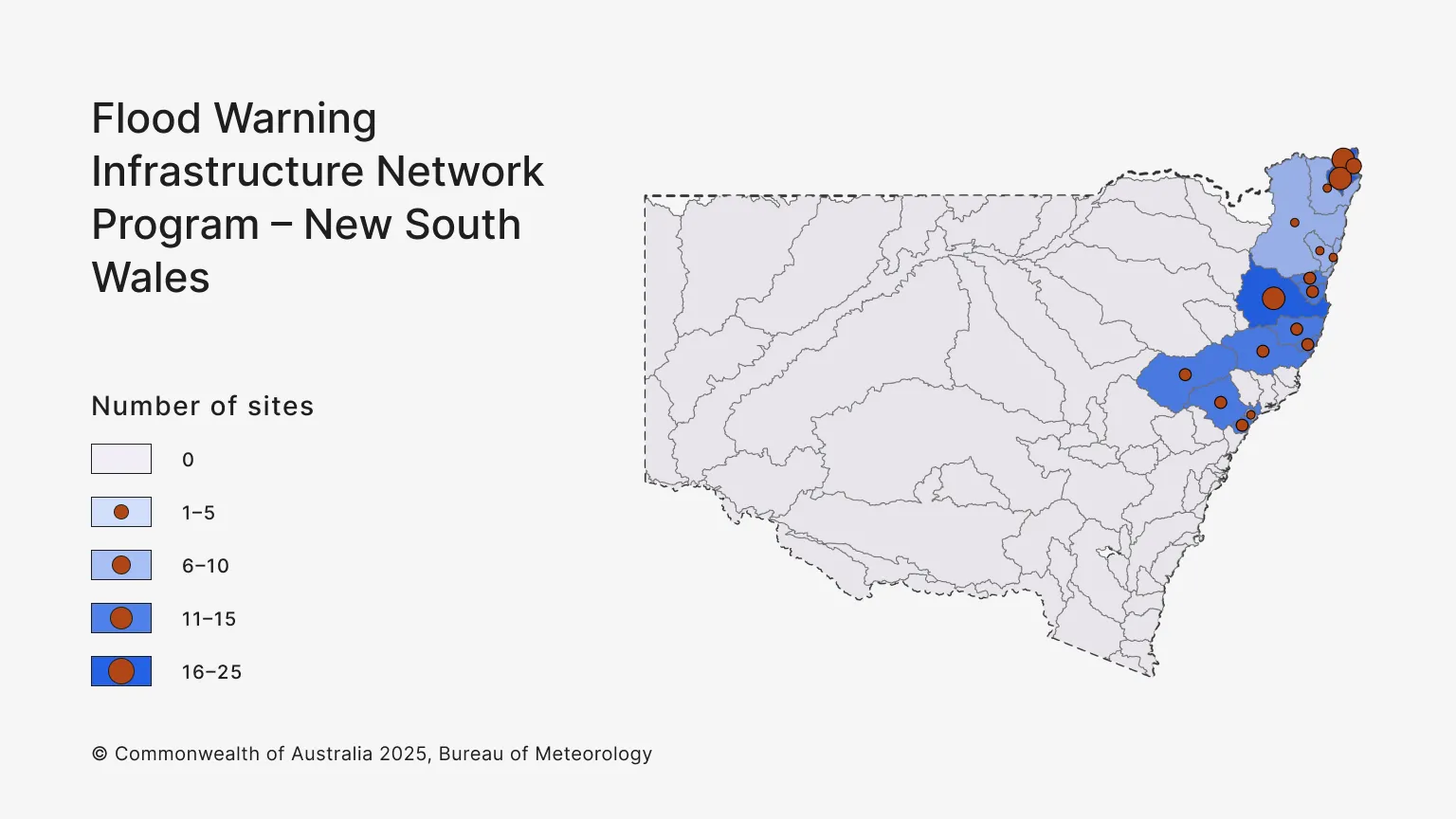
The full NSW/ACT program:
- includes about 258 flood gauge sites across 37 flood watch catchments
- involves 33 local government asset owners.
Progress
As of July 2026:
Stage 1 – Identify sites
Flood warning catchment priorities were:
- agreed with the NSW state government partner – NSW Department of Climate Change, Energy, the Environment and Water (DCCEEW) – in 2025
- discussed with the ACT government partner, Environment, Planning and Sustainable Development Directorate. Consultation with the ACT continues.
In NSW, we:
- worked closely with NSW DCCEEW and local government asset owners to identify priority flood gauge sites
- consulted with 34 local government asset owners through in‑person workshops to understand local priorities and community needs
- agreed in 2025 with NSW DCCEEW and local government asset owners on about 160 flood gauge sites to initially include in the FWIN Program.
Consultation continues between the Bureau and NSW asset owners to identify the remaining flood gauge sites to be included.
Stage 2 – Scope remediation works
- Detailed technical assessment of flood gauge sites began in 2025 to determine the level of remediation that may be required.
- 93 site assessment reports have been completed in NSW.
- Scope of works confirmed for 48 of these sites.
Stage 3 – Site acquisitions and clearances
Site acquisitions and clearances began, with transfer of equipment agreements issued to local councils in 2025.
We have acquired 31 sites in NSW. In addition, clearances are in progress:
- 31 sites have had due diligence completed
- 30 sites have been cleared in accordance with the Native Title Act, with one further site in progress
- 20 sites have been cleared for cultural heritage, and 11 require engagement with Traditional Owners
- 23 sites have tenure agreements completed, with a further 8 in progress
- 6 sites have had environmental assessments completed and a further 25 are in progress.
Stage 4 – Remediate sites
- Remediation work began in the Northern Rivers region in February 2026.
- 11 NSW sites are under remediation. This includes preparing work packages, vendor engagement, and physical site works.
Stage 5 – Transition to Bureau operations
- Installation is complete at one NSW site. Acceptance testing and transition to Bureau operations are in progress.
Stage 6 – Sites live, routine maintenance
- Our first NSW sites went live in June 2026.
- 2 NSW sites display data on our website and are part of our regular maintenance schedule.

Sites in NSW identified for acquisition
New South Wales sites
These sites are in our program of works for NSW. We will continue updating this list as more identified sites are confirmed. This list is current as of May 2026.
Ballina Shire Council
- Richmond River, 5.
Bellingen Shire Council
- Bellinger and Kalang Rivers, 8.
Byron Shire Council
- Brunswick River and Marshalls Creek, 9
- Wilsons River, 1.
Clarence Valley Council
- Clarence River, 1
- Coffs Coast, 4.
Coffs Harbour City Council
- Orara River, 1.
Lismore City Council
- Wilsons River, 20.
Nambucca Valley Council
- Nambucca River, 6.
Tweed Shire Council
- Brunswick River and Marshalls Creek, 6
- Tweed and Rouse Rivers, 23.
Department of Climate Change, Energy, the Environment and Water (Environment Restoration Fund)
- Richmond River, 9
- Wilsons River, 3.
Armidale City Council
- Macleay River, 2.
Cessnock City Council
- Wollombi Brook and Lower Hunter River, 7.
Kempsey Shire Council
- Macleay River, 18.
Lake Macquarie City Council
- Lake Macquarie, 8.
Mid‑Coast Council
- Manning and Gloucester River, 6.
Newcastle City Council
- Newcastle Area, 1.
Port Macquarie Hastings Council
- Camden Haven River, 6
- Hastings River, 1.
Upper Hunter Shire Council
- Goulburn and Upper Hunter Rivers, 7.