


Climate classification maps
These Australian climate classification maps and data are based on vegetation types, rainfall, and temperature and humidity. Select years, to see changes since 1951. Temperature and humidity maps are available since 1971, when suitable humidity data became available.
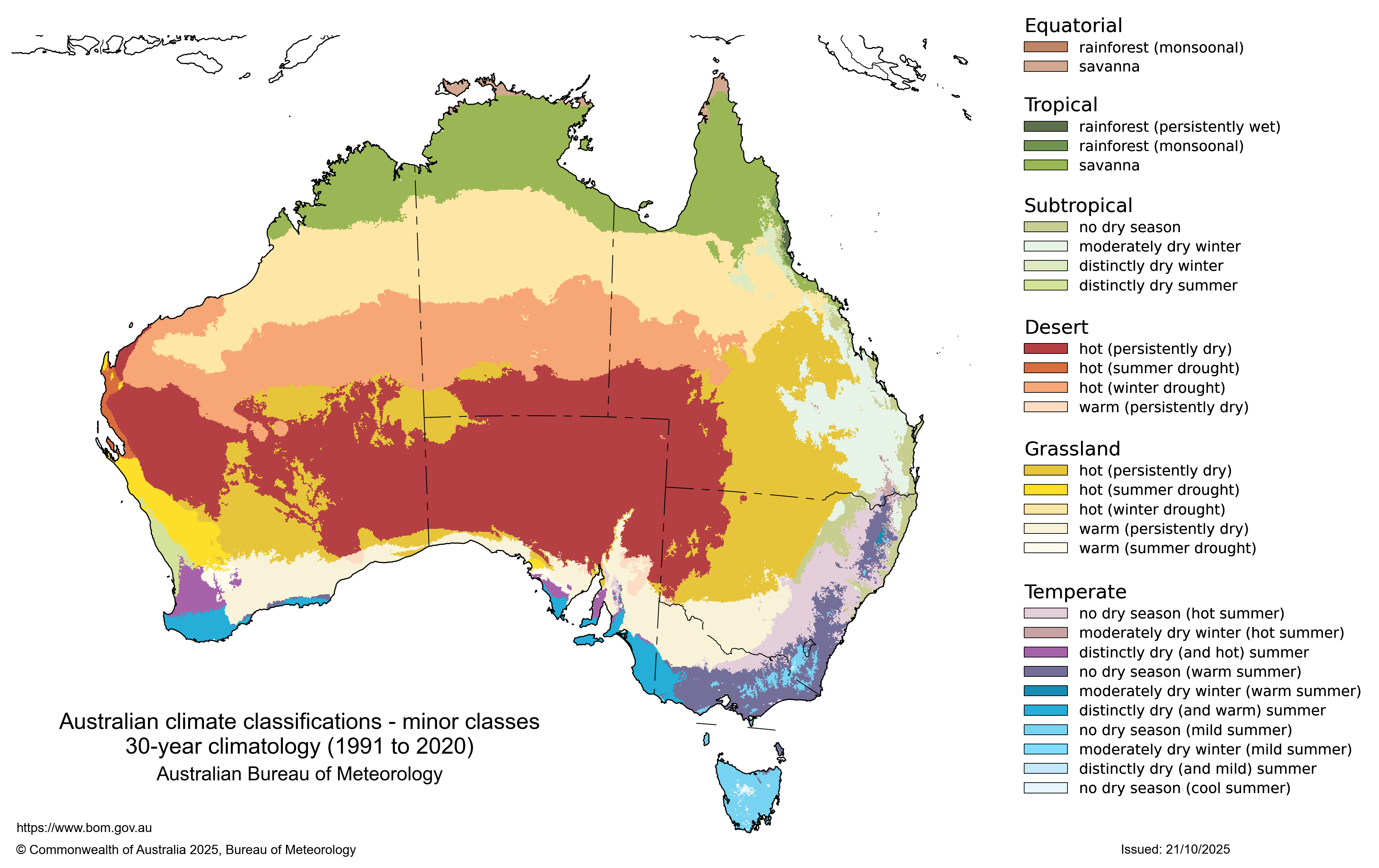
Mouse over or tap coloured areas on the map to see corresponding legend details.
Product code: IDCJCM0006
What do these maps show?
These maps show the Australian climate, based on a range of classification schemes including:
- Temperature and humidity
- Vegetation (Köppen)
- Seasonal rainfall
The types of classification method serve different purposes. For example, if you are choosing plants for a community garden without irrigation, you would want to make sure the plants will receive sufficient rainfall, on average, to thrive.
Each map is based on 30 years of observational data, showing changes in the distribution of these zones over time.
Köppen Australian climate classification maps
The Köppen maps divide Australia into six major climate classes and 28 sub-classes, based on the climatic limits of different types of vegetation. The Köppen classes are based on temperature and rainfall data collected between 1951 and 2020.
The Köppen classes are:
- Equatorial
- rainforest (monsoonal)
- savanna
- Tropical
- rainforest (persistently wet)
- rainforest (monsoonal)
- savanna
- Subtropical
- no dry season
- moderately dry winter
- distinctly dry winter
- distinctly dry summer
- Desert
- hot (persistently dry)
- hot (summer drought)
- hot (winter drought)
- warm (persistently dry)
- Grassland
- hot (persistently dry)
- hot (summer drought)
- hot (winter drought)
- warm (persistently dry)
- warm (summer drought)
- Temperate
- no dry season (hot summer)
- moderately dry winter (hot summer)
- distinctly dry (and hot) summer
- no dry season (warm summer)
- moderately dry winter (warm summer)
- distinctly dry (warm summer)
- no dry season (mild summer)
- moderately dry winter (mild summer)
- distinctly dry (mild summer)
- no dry season (cool summer)
Note: There are no cold or polar zones in Australia.
Seasonal rainfall maps
The seasonal rainfall maps use the differences between summer and winter rainfall across Australia to identify six major climate zones and 16 sub-zones. These zones are determined using the median annual rainfall and seasonal incidence (the ratio of the median rainfall over the warm period, November to April, to the cool period, May to October). The seasonal rainfall zones are based on rainfall data collected between 1951 and 2020.
The seasonal rainfall zones are:
- Summer dominant (Marked wet summer and dry winter, annual rainfall more than 350 mm)
- Annual rainfall more than 1200 mm
- Annual rainfall 650–1200 mm
- Annual rainfall 350–650 mm
- Summer (Wet summer and low winter rainfall, annual rainfall more than 350 mm)
- Annual rainfall more than 1200 mm
- Annual rainfall 650–1200 mm
- Annual rainfall 350–650 mm
- Uniform (Rainfall spread quite evenly across the seasons, annual rainfall more than 250 mm)
- Annual rainfall more than 800 mm
- Annual rainfall 500–800 mm
- Annual rainfall 350–500 mm
- Winter (Wet winter and low summer rainfall, annual rainfall more than 250 mm)
- Annual rainfall more than 800 mm
- Annual rainfall 500–800 mm
- Annual rainfall 350–500 mm
- Winter dominant (Marked wet winter and dry summer, annual rainfall more than 250 mm)
- Annual rainfall more than 800 mm
- Annual rainfall 500–800 mm
- Annual rainfall 350–500 mm
- Arid (where rainfall is lower than the minimum amount for the other categories) that is, annual rainfall less than 350 in summer dominant regions and annual rainfall less than 250 in summer dominant regions
The six major classification groups identify the season of highest rainfall in each area, and are similar in distribution to the annual rainfall maps.
Temperature and humidity maps
This classification identifies six key zones across Australia, defined by seasonal temperature and humidity characteristics. The temperature and humidity zones are based on temperature and humidity data collected between 1971 and 2020.
The classification identifies six key zones across Australia, defined by seasonal temperature and humidity characteristics. The temperature and humidity zones are based on temperature and humidity data collected between 1971 and 2020.
The seasonal temperature and humidity zones are:
- Hot humid summer
- Warm humid summer
- Hot dry summer, mild winter
- Hot dry summer, cold winter
- Warm summer, cold winter
- Mild to warm summer, cold winter
These zones reflect regional climate variations, from hot humid summers in northern Australia to cold winters in Tasmania and alpine regions, and can be compared to the maps for temperature and relative humidity.
Why 30-year periods?
Climate is often colloquially considered as the "average weather" of a region, which can be more rigorously described as the mean and variability of certain elements (including the temperature, rainfall, and wind) over a period of time. The World Meteorological Organisation identified 30 years as the appropriate length of time to calculate these values (referred to as climate normal) as this window of time sufficiently captures climate variability. The WMO climate normals are updated at the end of every decade (WMO, 2025). These maps show Australia's climate based on current and past climate normals from 1951, or from 1971 for maps which require humidity data for calculations.
Each map is based on combinations of annual and monthly average (or total) values, for rainfall and/or temperature. Monthly averages are calculated by adding monthly values and dividing by the number of years in the specified period. Annual values are based on the monthly values (usually the mean of the monthly values or the sum of them).
The data to create these maps is the Australian Gridded Climate Data (AGCD) data set (Jones, Wang, & Fawcett, 2009; Evans, Jones, Smalley, & Lellyett, 2020).
![]() Unless otherwise noted, all maps, graphs and diagrams in this page are licensed under the Creative Commons Attribution 4.0 International Licence
Unless otherwise noted, all maps, graphs and diagrams in this page are licensed under the Creative Commons Attribution 4.0 International Licence
