Summary
Tropical Cyclone Koji was a short-lived tropical cyclone that peaked as a category 2 tropical cyclone in the Coral Sea, then weakened before crossing the Queensland coast between Ayr and Bowen as a tropical low. The duration and impact of this weather event over north and western Queensland was extensive.
On 7 January 2026 tropical low 12U formed within a monsoon trough in the northern Coral Sea. Initially tropical low 12U moved slowly westwards until 9 January, when the monsoon and a mid-level ridge to the east steered the tropical low towards the south. From 10 am AEST (0000 UTC, AEST=UTC+10) 9 January gales began to intermittently occur in the southeast quadrant. An increase in monsoon flow to the north, combined with an increase in southeasterly winds to the south of the low resulted in the tropical low's broad structure.
Overnight on 9 January and into the morning of 10 January, gales began to extend around the centre. At 10 am AEST (0000 UTC) 10 January Tropical Cyclone Koji was named, while located about 330 km north northeast of Townsville. Later during 10 January, Tropical Cyclone Koji intensified, and storm force, category 2, winds were observed at Willis Island.
As Koji approached the Queensland coast to the south of Townsville, the strongest winds were recorded to the south of the centre, at the Whitsunday Islands. A wind gust of 117 kilometres per hour (63 knots) was recorded at Hamilton Island at 8:36 am AEST 11 January (2236 UTC 10 January), and northeast of the Whitsundays at Hardy Reef at 11 am AEST (0100 UTC) 11 January. Prior to Koji making landfall, the extent of gales reduced to less than half-way around the centre, resulting in the system being classified as a tropical low. Ex-Tropical Cyclone Koji crossed the coast between Ayr and Bowen around 0000 UTC (10 am AEST) 11 January, then proceeded to move inland over the following days.
Strong winds brought down trees and branches causing some structural damage and power outages, mostly in the Mackay and Whitsunday region. Some boats broke their moorings and were damaged.
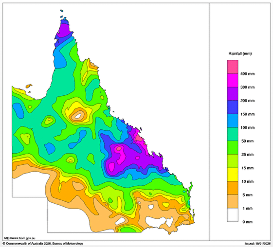
Heavy rainfall was extensive, with several sites in the Pioneer River catchment observing more than 350 mm of rainfall in 24 hours to 9am on 11 January (2300 UTC 10 January). Heavy rainfall continued through 12 January. The highest rainfall observed was at Mt William with 601 mm recorded in the 48 hours to 9am 12 January (2300 UTC 11 January).
Major flooding occurred south of Mackay in the Pioneer catchment. Ex-Tropical Cyclone Koji could be tracked as it moved inland for several days, enhancing heavy rainfall along its path. As Ex-Tropical Cyclone Koji moved inland, moderate to major flooding occurred in basins along the track, all the way to the Northern Territory border. The weekly rainfall totals are shown below.
The highest storm tides observed were between 0.5 and 1.0 metres near Bowen and Airlie Beach, but the resulting tides were well below the highest astronomical tides.
Tropical Cyclone Koji was the seventh tropical cyclone in the Australian region for the 2025/26 season.
For more information see the TC Koji Report
Track and Intensity
(Times in AEST, UTC+10h)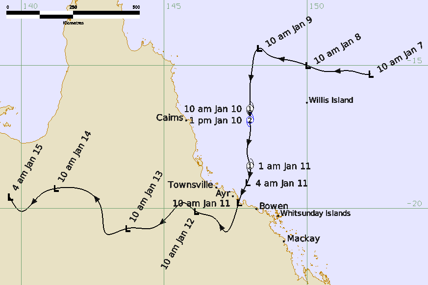
Weekly rainfall totals
(11-17 January 2026)