


Summary
A tropical low (07U) caused widespread heavy rain leading to flooding to North West Queensland and eastern Northern Territory.
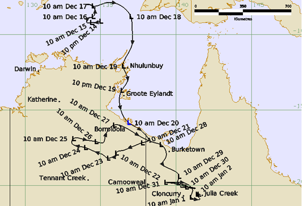
A weak low formed in mid-December in the Arafura Sea north of the Northern Territory. It was initially slow moving before moving to the east on 17 December then turning to the south on 18 December. The low passed close to Nhulunbuy on the northeast NT coast on 19 December then accelerated down the western Gulf of Carpentaria coast past Groote Eylandt making landfall on the southern Gulf coast on 20 December. Although the general environment was favourable for development, the circulation failed to consolidate and remained weak.
The low then remained over land but retained its structure through late December and early January meandering over eastern Northern Territory and North West Queensland. Storm activity increased at times especially from 27-30 December over northwest Queensland causing high rainfall totals, exacerbated by the slow motion of the low. The low dissipated on 2 January although isolated storm activity persisted over following days owing to the high moisture. The two weekly rainfall maps below show the distribution of falls in the week to 25 December 2025 and then to 1 January 2026.
Cumulative rainfall totals exceeded 500 mm over parts of North West Queensland including Normanton, Cloncurry and Julia Creek as shown in the table below.
Significant flooding occurred over North West Queensland. Major flood levels were exceeded on the Flinders and Leichardt River Catchments, while moderate flood levels were reached on the Cloncurry, Diamantina, Georgina, Norman, Nicholson and Gilbert River Catchments. Subsequent rainfall events continued flooding across North West Queensland for some time and the floodwaters gradually flowed south.
A man died when he his vehicle was submerged in floodwaters at Normanton on 30 December. Flooding caused significant stock losses, estimated at over 100 000 cattle. Many roads were closed cutting access to many communities including Normanton, Karumba, Burketown, Doomadgee, Julia Creek and Winton. The Flinders Highway and Great Northern Railway suffered prolonged closures and damage.
In the Northern Territory widespread heavy rainfall occurred in the upper catchment of the McArthur River resulted in the near inundation of the Borroloola Bridge. The river rose to 8.7m on 30 December to reach the level of the Borroloola Bridge deck.
Track and Intensity (Times in AEST,UTC=10h)
Rainfall
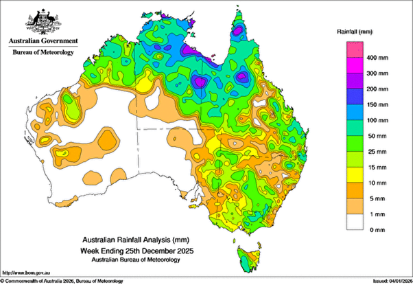
Weekly rainfall totals for Australia 19/12/2025 – 25/12/2025.
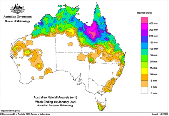
Weekly rainfall totals for Australia 26/12/2025 – 01/01/2026
| Name | Station No. | Total rainfall 20 Dec-5 Jan. (mm) | Highest daily fall (mm) | Date |
|---|---|---|---|---|
| Gilliat River | 529041 | 639.0 | 218.0 | 30-Dec |
| Savanah | 529079 | 618.0 | 171.0 | 30-Dec |
| Broadwater | 529047 | 617.0 | 142.0 | 29-Dec |
| Glen Idol | 529029 | 616.0 | 170.0 | 30-Dec |
| Normanton Airport | 29063 | 606.2 | 123.6 | 29-Dec |
| Fort Constantine | 29075 | 598.0 | 231.0 | 29-Dec |
| Normanton | 529049 | 597.0 | 111.0 | 29-Dec |
| Snake Creek | 529092 | 594.0 | 197.0 | 30-Dec |
| Etta Plains | 529018 | 593.0 | 162.0 | 29-Dec |
| Punchbowl | 529043 | 588.0 | 139.0 | 30-Dec |
| Julia Creek Airport | 29058 | 584.2 | 151.8 | 30-Dec |
| Fish Hole Creek | 529076 | 577.0 | 295.0 | 29-Dec |
| Prospect | 529075 | 562.0 | 112.0 | 28-Dec |
| Claravilee | 529077 | 559.0 | 199.0 | 29-Dec |
| Walkers Bend | 529007 | 553.0 | 173.0 | 28-Dec |
| Brinard Station | 29092 | 552.2 | 215.0 | 30-Dec |
| Gereta Station | 29131 | 542.5 | 120.0 | 25-Dec |
| Yappar River | 29154 | 536.5 | 146.0 | 29-Dec |
| Oakland Park | 529074 | 535.0 | 313.0 | 29-Dec |
| Cloncurry | 529011 | 526.0 | 120.0 | 26-Dec |
| Dugald River | 529015 | 523.0 | 100.0 | 29-Dec |
