Summary
Tropical Low 29U formed in the Coral Sea before crossing the Far North Queensland coast south of Cairns, producing heavy to intense rainfall and widespread riverine and flash flooding across northern Queensland. The remnants of the low later contributed to further heavy rainfall, leading to major riverine and flash flooding across parts of central and southeastern Queensland.
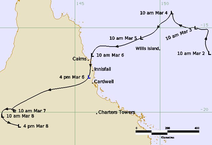
An active phase of the Madden-Julian Oscillation supported the formation of a weak, elongated low in the Coral Sea on 2 March. During 2 and 3 March the low moved to the northwest and slowly developed. Overnight on 3 March the deep convection banding around the centre increased and the structure of the low improved. Between 0000 UTC and 0600 UTC 4 March (1000 and 1600 AEST) the system briefly produced gale‑force winds in the northwest quadrant while it was located to the north of Willis Island. Unfavourable environmental conditions, including strong easterly vertical wind shear, weakened the low by 1200 UTC 4 March (2200 AEST). It then moved westwards, crossing the North Tropical Coast between Cairns and Innisfail about 0400 UTC 6 March (midday AEST).
The maximum wind gusts recorded as 29U crossed the coast were 89 km/h from Low Isles Lighthouse and 85 km/h from Arlington Reef on 5 March.
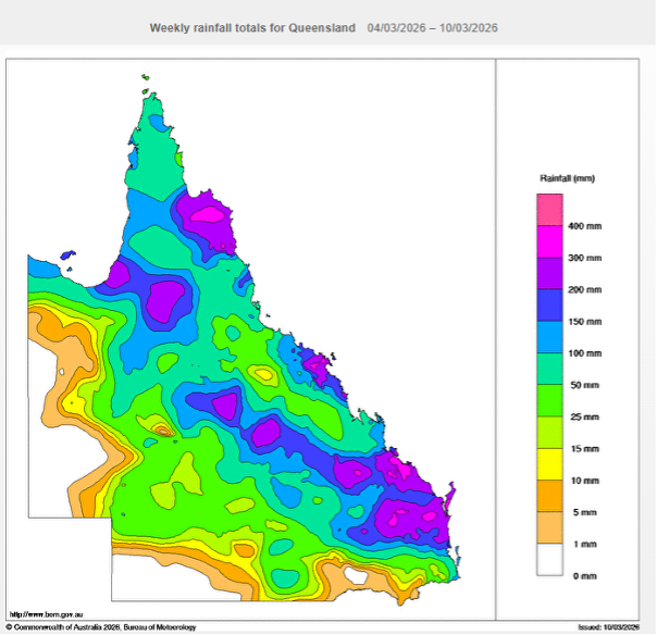
The low produced heavy to intense rainfall over the region which caused major flooding of the Daintree River. The Daintree Ferry which connects the northern Daintree rainforest and Cape Tribulation with the rest of far north Queensland broke its moorings and became tangled with another vessel as the river levels rose rapidly to major flood heights. The community of Wujal Wujal became isolated due to road damage and closures. After landfall 29U moved westwards and weakened over central Queensland by 8 March, but its associated rainfall triggered renewed and significant flooding across inland Queensland and Cape York, including the Georgina and Eyre Creek, Flinders, Thomson Barcoo Cooper, Normal Gilbert, and Diamantina catchments. This resulted in ongoing road closures and prolonged isolation of communities such as Normanton and Karumba, which had already been cut off since December. Supply shortages were also reported in Mount Isa, with supermarket shelves left empty.
The remnants of the low later interacted with an upper trough, producing further heavy to intense rainfall across central and southeastern parts of Queensland between 6 — 9 March. Major flood levels were recorded in the Fitzroy Catchment, Baffle Creek, the Burnett River, the Kolan River, the Mary River and the Condamine River. Numerous communities and roads were inundated, livestock losses were reported and widespread power outages occurred. Two Chinese tourists drowned when their car was swept off Kilkivan Tansey Road. Many residents required evacuation, and multiple rescues were undertaken, including 34 people removed from a stranded bus near Miriam Vale. The city of Bundaberg on the Burnett River experienced significant inundation as the river peaked at around 7.4m.
Track and Intensity (Times in AEDT, UTC+10h)
Rainfall
Weekly rainfall totals across Queensland for the 7 days between 4 — 10 March 2026.