Summary
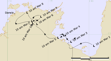
Tropical Low 31U was a significant tropical low which caused widespread flooding over parts of the Northern Territory. 31U formed over the Gulf of Carpentaria embedded in the monsoon trough on 2 March 2026. The system initially moved westwards, moving over land for the first time near the Northern Territory/Queensland border around 1200 UTC 2 March. On 3 March, the system moved back out over the Gulf of Carpentaria waters where it remained for the next two days while tracking slowly westwards. The proximity of 31U to land hampered further development, with the strongest winds of 25 to 30 knots observed during 4 March while over the western Gulf of Carpentaria waters.
31U moved over land for a second time around 0000 UTC 5 March north of Borroloola in the Northern Territory and moved slowly northwest over the Top End during 5 and 6 March. Over the next few days, 31U was slow-moving over the Top End, and the circulation became increasingly disorganised within the monsoon trough. 31U dissipated within the monsoon trough on 10 March, after which monsoonal conditions persisted over northern Australia exacerbating and prolonging the flooding associated with 31U.
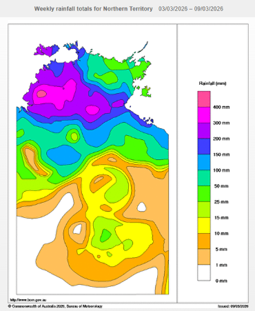
While 31U did not intensify into a tropical cyclone, the system led to extensive rainfall and riverine flooding impacts over the Northern Territory. Weekly rainfall totals from 3-9 March exceeded 200 mm for large parts of the Top End. In the 24 hours to 9am ACST 6 March, rainfall totals of 150-250 mm over the Katherine region were observed, with further widespread falls of more than 40-60 mm observed throughout western parts of the Top End. This rainfall contracted to the west during the 24 hours to 9am ACST 7 March, with widespread rainfall totals between 50-150 mm recorded through the western Top End, with isolated intense falls up to 250 mm. In subsequent days, heavy to intense rainfall became more isolated but continued to affect the northwestern Top End. This included daily rainfall totals between 100-200mm through the Darwin rural area on 9 and 10 March. Several stations exceeded their previous highest daily, 4-day and 7-day rainfall records for March during this event and subsequent weather. In the 24 hours to 9am ACST 6 March, annual daily rainfall records were recorded at Upper Fergusson River (218 mm), Wandie Creek (196 mm), and Mount Stow (165 mm), and March daily rainfall records were recorded at Edith Falls Ridge (230 mm), and Edith Farms Road (215 mm).
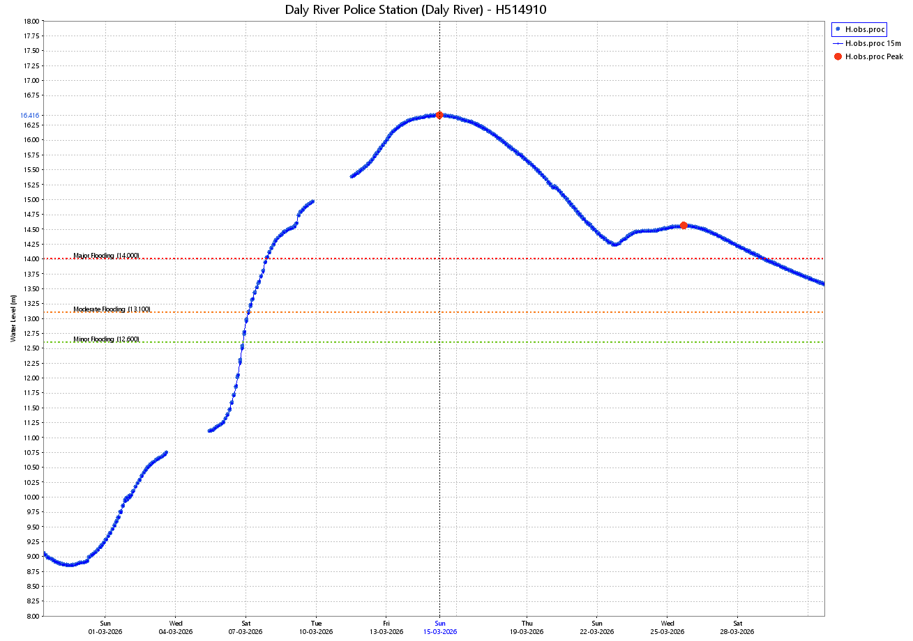
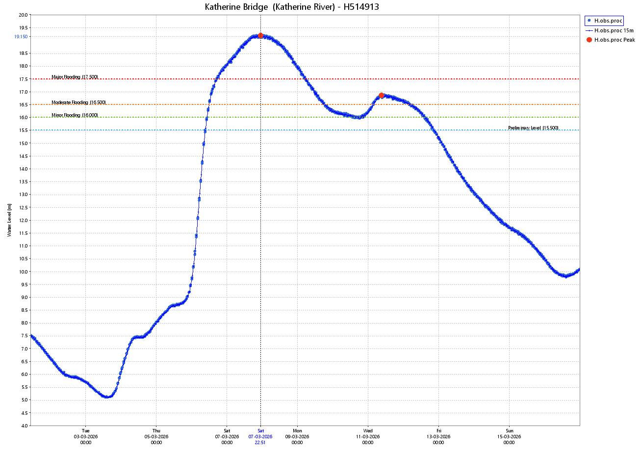
In response to this rainfall, several rivers exceeded warning thresholds. The Katherine River at Katherine Bridge exceeded the Major flood level with a peak height of 19.21 m on 7 March, resulting in the worst flooding event since 1998. The Daly River at Daly River Police Station exceeded the Major flood level with a peak height of 16.42 m on 15 March, resulting in the worst flooding event on record and causing Nauiyu to be evacuated. The Waterhouse River also exceeded the Major flood level with a peak height of 9.32m.
Track and Intensity (Times in ACST, UTC+9.5h)
Rainfall
Map of weekly rainfall totals for the Northern Territory. 31U caused widespread rainfall exceeding 200 mm across parts of the Top End.
Riverine flooding
Hydrograph for the Katherine River showing the river height recorded at Katherine Bridge between 5 March to 10 March. The Katherine River exceeded Major Flood Level from 6 March to 9 March, with a peak height of 19.21 m on 7 March.
Hydrograph for the Daly River showing the river height measured at Daly River Police Station between 1 March and 27 March. The Daly River exceeded Major Flood Level for an extended period from 8 March, with a peak height of 16.42 m on 15 March.