Summary
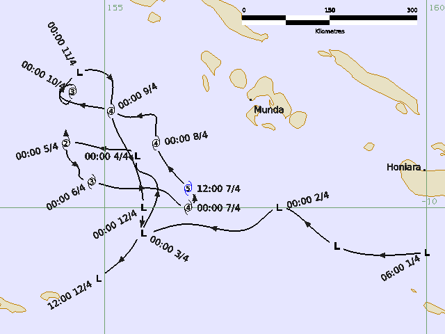
Severe Tropical Cyclone Maila peaked as a category 5 system all while located within the Solomon Sea. Maila is the strongest system on record within the Solomon Sea and resulted in some significant impacts to parts of the Solomon Islands and Papua New Guinea (PNG).
A tropical low (37U) developed south of Honiara in the Solomon Sea, at 0600 UTC 1 April. The tropical low initially tracked northwest, over waters to the south of the New Georgia Islands and west of Guadalcanal (Solomon Islands). The system gradually intensified, and it reached tropical cyclone intensity at 1500 UTC 4 April, while located about 615km west of Honiara and 800km east of Port Moresby. At this time, the system was within the Papua New Guinea Area of Responsibility and was named Maila.
Maila remained slow-moving and continued to intensify, reaching severe tropical cyclone strength at 1200 UTC 5 April. Rapid intensification followed, with the system peaking at 110 kn (205 km/h), category 5 at 1200 UTC 7 April. The system weakened slightly on 8 April before intensifying again, reaching a second peak of 100 kn (185 km/h), category 4 late on 8 April.
The system started to weaken from 9 April and by the morning of 11 April, gales were confined to the northern quadrants of the circulation. In line with the Australian definition of a tropical cyclone requiring gales to extend more than halfway around the system, Maila was reclassified as Ex-Tropical Cyclone Maila. At this time, the system was located over waters between Muyua Island (also known as Woodlark Island), Papua New Guinea and the New Georgia Islands, Solomon Islands. Ex-Tropical Cyclone Maila continued to weaken with gales easing by 1200 UTC 11 April. During 12 April, the remnants of Maila adopted a southwesterly track before weakening into a trough.
For more information see the Severe Tropical Cyclone Maila report (docx).
Track and Intensity Times in UTC (AEST-10h)