Summary
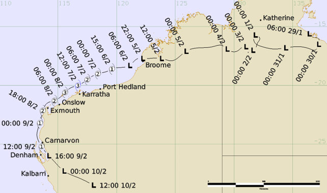
Severe Tropical Cyclone Mitchell began as a tropical low (21U) over the Northern Territory. It produced significant inland flooding before moving west and offshore near Broome. Once over water, it tracked west-southwest roughly parallel to the Pilbara coast and rapidly intensified to reach category 3 strength before weakening and eventually crossing the coast as a tropical low near Shark Bay.
Initially forming as a tropical low over land west of the Gulf of Carpentaria on 29 January, the system produced days of heavy rainfall across the Northern Territory as it moved slowly westwards. This resulted in the Daly River reaching major flood levels and caused the evacuation of 447 people from the nearby community of Nauiyu/Daly River.
Continuing to head generally westwards across the Kimberley, the tropical low moved offshore near Broome around 2200 UTC 5 February. It intensified to tropical cyclone strength by 1500 UTC 6 February and was named Mitchell. The system then moved west-southwest, roughly parallel to the Pilbara coastline where it rapidly intensified, reaching its peak intensity as a 75 kn (140 km/h) category 3 system at 1200 UTC 7 February over water north of Karratha.
During 8 February, Mitchell weakened to category 2 strength and moved around the North West Cape, offshore from Exmouth, before then turning south. The system moved down the upper west coast as a category 1 tropical cyclone before weakening to a tropical low with quadrant gales offshore south of Carnarvon. It finally crossed the coast near Shark Bay around 1600 UTC 9 February before weakening inland and dissipating after 1200 UTC 10 February.
Mitchell did not pass close enough to coastal communities to cause any significant wind damage on the Pilbara coast. However, there were downed trees, power outages and significant disruptions to offshore industry operations for several days. Further south, strong winds caused significant banana crop losses in the Carnarvon area, while localised winds impacted some structures in the Wheatbelt.
For more information see the Severe Tropical Cyclone Mitchell report (docx).
Track and Intensity Times in UTC (ACST-9.5h, AWST-8h)