Summary
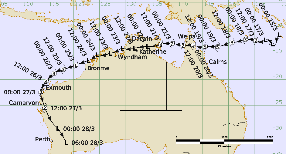
Severe Tropical Cyclone Narelle was a long-lived system that crossed the coasts of far north Queensland, Northern Territory and Western Australia at severe intensity, only the second cyclone to do so following Ingrid (2005).
Tropical Low 34U formed near the southern Solomon Islands on 15 March and moved on a general westerly track over following days. Tropical Cyclone Narelle was named on 17 March and reached category 3 intensity the following day, then began a period of rapid intensification to peak at a maximum 10-minute mean wind of 115 kn (215 km/h, category 5 intensity) on 19 March. Narelle weakened slightly to category 4 intensity as it crossed the Far North Queensland coast between Coen and Lockhart River on the morning of 20 March, sparing those communities from the worst conditions. Strong winds extended across Cape York Peninsula to Weipa on the eastern Gulf of Carpentaria coast and caused mostly minor building damage and power outages with many trees and branches down. The strongest gust recorded was at 62 kn (115 km/h) at 2258 UTC 19 March from Lockhart River. Heavy rainfall caused flooding of properties and roads.
Narelle weakened as it moved over Cape York Peninsula and emerged into the Gulf of Carpentaria near Aurukun, south of Weipa, at category 2 intensity late on 20 March. The tropical cyclone continued on a steady westward track and redeveloped into a severe tropical cyclone once it was back over open water. Narelle reached a second peak maximum 10-minute mean wind intensity of 70 kn (130 km/h, category 3) before crossing the Northern Territory coast in a sparsely populated area between Nhulunbuy and Groote Eylandt early on 22 March at category 3 strength. Reports of wind damage were mostly related to trees and branches down and power outages. The strongest gust recorded was 49 kn (91 km/h) at 1832 UTC 21 March from Ngayawili.
Narelle then moved west across the Top End of the Northern Territory. Despite weakening below tropical cyclone intensity soon after landfall, the system produced heavy rain over already saturated catchments, especially the Daly River region which had previously experienced record flooding only weeks earlier. On 23 March, the low moved across Joseph Bonaparte Gulf and over land across the north Kimberley causing heavy rain before moving offshore on 24 March.
Narelle redeveloped into a tropical cyclone northwest of Broome early on 25 March and quickly reached severe category 3 intensity later that day, north of Port Hedland, as it moved west southwest parallel to the Pilbara coast. The system had developed into a large circulation and despite being located about 150 kilometres to the north of the Pilbara coast, many coastal locations experienced a prolonged period of gale force, and at times storm force winds as Narelle moved west. This caused mostly minor damage to the communities east of Onslow but there was significant disruption to the ports, airports and industry.
On 26 March, Narelle turned to the southwest and moved closer to the west Pilbara coast. Narelle reached a third and final peak maximum 10-minute mean wind intensity of 85 kn (155 km/h, category 3) between 0600 and 1800 UTC 26 March. The tropical cyclone then turned south and passed just west of Exmouth early on 27 March.
For more informaiton see the Severe Tropical Cyclone Narelle (2026) Report.
Track and intensity (Times in UTC=AEST-10h, ACST-9.5h, AWST-8h)