
What is the Australian monsoon?
The monsoon is a seasonal reversal of winds over parts of the tropics. The word comes from the Arabic term 'mausam', meaning season.
The monsoon is mostly active in our summer months. It is part of northern Australia's wet season from November to April. But monsoon bursts of rainfall can also happen earlier or later.
The monsoon can bring:
- cloudy conditions
- long periods of heavy rain
- occasional thunderstorms, and
- fresh to strong squally winds.
This can lead to floods in affected areas.
Video: Ask the Bureau: What is the monsoon?
In the buildup to the wet season, summertime heating warms up the land faster than the surrounding oceans, creating an area of low pressure. This helps to draw the monsoon trough south over the Australian continent with dry southeasterly trade winds shifting to moist north-westerly winds. When this wind change arrives, the tropics are affected by monsoonal conditions.
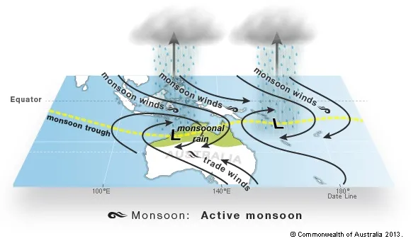
During an active monsoon, the sky is filled with dark clouds bringing widespread rain and thunderstorms. These wet conditions can last for a few days or even a week or more.
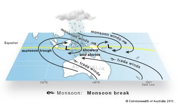
An active monsoon period can be followed by an inactive or break monsoon period. This is when the weather returns to pre-monsoonal or buildup conditions.
Northern Australia typically sees about three monsoon bursts each wet season. Monsoonal rains deliver the majority of the annual rainfall across the tropical north. Although it can cause flooding and cut off roads, it's also vital for life across the tropical north.
How the Australian monsoon works
In northern Australia, the prevailing wind is from the east or south-east for most of the year. During active monsoon periods – any time from November to April – the winds shift to become north-westerly at the surface.
As summer approaches, the continent heats up. Low pressure draws the monsoon trough – a zone of low pressure and rising air – over northern Australia. This trough draws in moist air from the Indian Ocean and southern Asian waters.
This influx of moist air is what we call the monsoon. The monsoon trough frequently spawns individual low pressure systems, producing heavy rain and flooding.
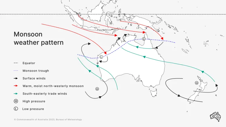
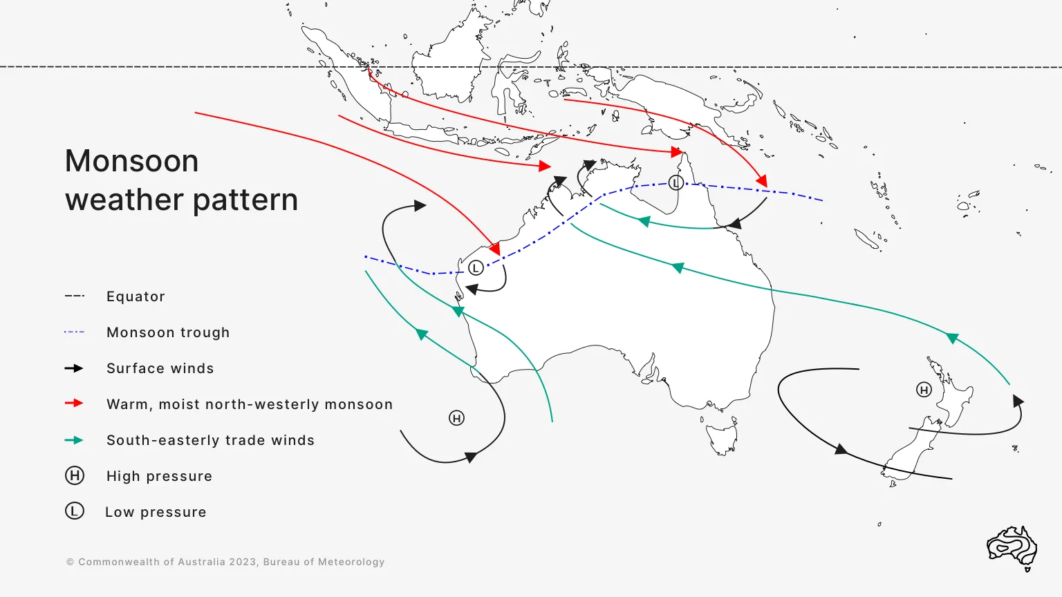
Synoptic patterns typically associated with the active phase of the northern Australian monsoon. The monsoon trough is an area of low pressure.
Monsoon phases
The monsoon has active and inactive phases.
A typical wet season consists of a prolonged inactive phase during the build-up (the period before initial onset). After this, there are usually 2 to 4 active–inactive cycles.
Inactive phases are usually longer than active ones. Each full cycle lasts about 4–8 weeks.
Transitions from active to inactive monsoon phases may be associated with the Madden–Julian Oscillation.
Active phase
The active phase is usually associated with broad areas of cloud and rain. There are sustained moderate to fresh north-westerly winds on the north side of the trough.
If the trough is close to or over land, there may be widespread heavy rain.

Inactive phase – a break in the monsoon
An inactive phase happens when the monsoon trough temporarily weakens or retreats north of Australia.
Also called a break in the monsoon, this phase brings light winds and isolated shower and thunderstorm activity, sometimes with gusty squall lines.

When is the Australian monsoon?
The northern wet season extends from about October to April in the far north of the Northern Territory. It generally starts later and ends earlier elsewhere. Active monsoon phases may happen at any time during this period.
The initial monsoon onset – the reversal of the winds – normally happens in late December around Darwin.
Later than normal onset is often associated with a positive phase of the Indian Ocean Dipole or El Niño conditions in the Pacific. La Niña is often associated with an early onset. Learn more about El Niño and La Niña.