
Impact of ocean currents
Ocean currents refer to the movement of water from one location to another. They transport water long distances and re-distribute heat, salt, oxygen, and nutrients.
These currents have a big impact on:
- weather and climate, by moving heat toward the poles
- the biological characteristics of the waters through which they flow
- human activities such as fishing and boating.
How ocean currents form
The following forces generate and drive ocean currents.
Direction
The direction of the current is influenced by the:
- rotation of the Earth
- depth and shape of the sea floor
- shape of coasts
- wind direction
- position of other currents.
Short-term events such as earthquakes can also create changes in currents.
Speed
Currents are generally measured in metres per second (m/s) or in knots. One knot is 1.85 km/h or 0.5144 m/s.
The Gulf Stream is the world's fastest current, reaching up to 2.5 m/s.
Typical speeds for the Leeuwin Current are 0.5 m/s. The core of the East Australian Current can reach 2 m/s.
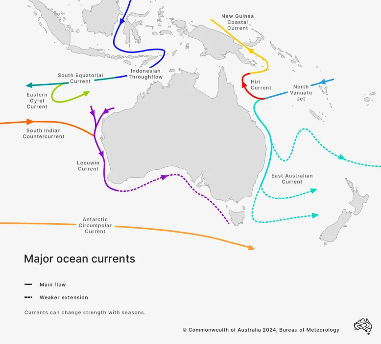
Australian region ocean currents
There are several significant currents in our region. The major ones are the East Australian Current and the Leeuwin Current. Others include the:
- Indonesian Throughflow
- South Equatorial Current
- Antarctic Circumpolar Current.

Currents on ocean maps
Compared to the diagram above, currents on our ocean maps appear much more chaotic. They look less like rivers and more like turbulent wind patterns with swirling, temporary features called ocean eddies. How they appear on these maps is also shaped by the seasons and other forces.
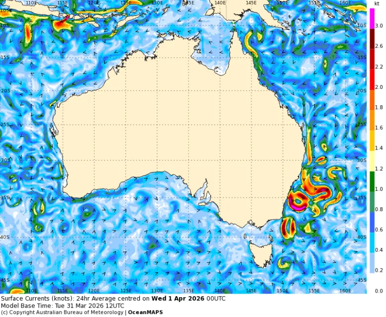
Currents look very different on our ocean maps. For example, the swirling ocean eddies of the East Australian current are clearly visible.
How salinity and temperature drive currents
Sea surface salinity measures the concentration of dissolved salt in sea water, near or at the ocean surface.
Measuring salinity is key to understanding global water cycles and how water moves around the oceans.
About 85% of evaporation and 80% of precipitation – rain and snow – happen over the Earth's oceans.
- Evaporation removes fresh water, increasing the salinity of the local ocean.
- Rainfall, snow and rivers add fresh water, decreasing salinity.
These changes in salt concentration affect the density of surface waters, which affects how water moves around.
Salinity values
Sea surface salinity in the open ocean generally ranges between 32 and 37 practical salinity units (psu – grams of salt per litre or kilogram of water).
It may be much lower near fresh water sources and can be as high as 42 psu in the Red Sea – one of the saltiest bodies of water in the world.
Impact on water movement
Salinity and temperature determine the density and buoyancy of sea water.
- The volume of water contracts as it cools.
- When it contracts, there is the same amount of salt in a smaller volume of water.
- The saltier water is more dense and heavier.
- Heavier water tends to sink, which lowers the sea-surface height.
In warmer waters:
- Water volume expands.
- There is the same amount of salt to fill the greater volume.
- This makes the water less dense and lighter.
- The sea surface is higher.
These temperature and salinity variations drive ocean circulation, creating a 'global conveyor belt'.

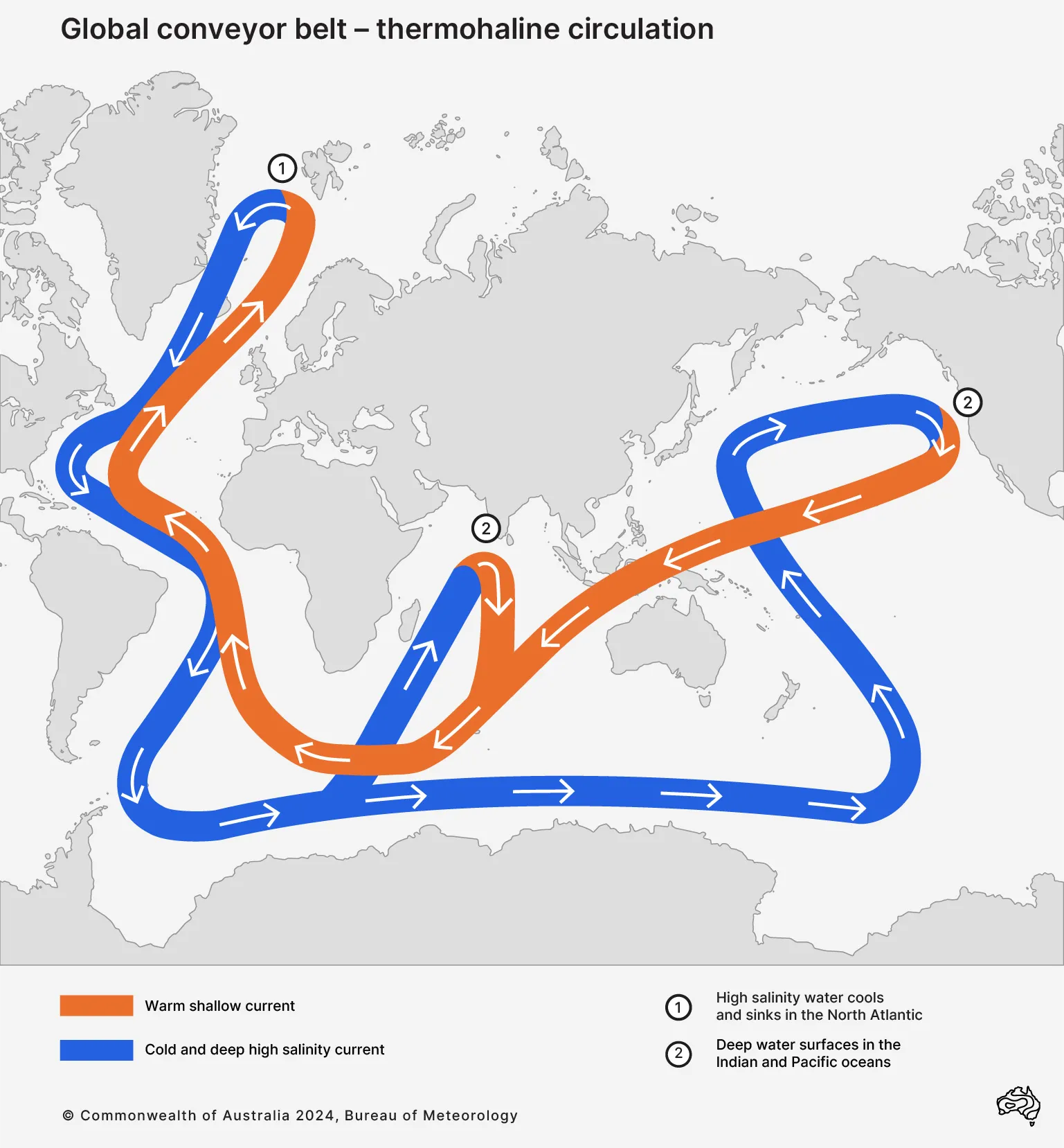
It takes about 1000 years to take a trip on the global conveyor belt, which moves heat and salt around the world
Global conveyor belt
The global conveyor belt is powered by thermohaline circulation – the movement of heat (thermo) and salt (haline) around the world.
The conveyor belt 'starts' in the Norwegian Sea. Warm water from the Gulf Stream heats the atmosphere in the cold northern latitudes.
Losing heat to the atmosphere, the water cools and becomes more dense. It sinks to the bottom of the ocean.
As more warm water is carried north, the cooler water is pushed south. It flows south of the equator, travelling to Antarctica.
The water returns to the surface through upwelling and mixing. Mixing is due to forces such as wind and tides. It can change the temperature, salinity and nutrients.
It takes about 1000 years to make a full trip on the global conveyor belt.
Upwelling, downwelling and the Ekman transport
When winds that blow across the ocean push surface water away, more water rises from below to replace it. The water that rises is generally colder and has more nutrients. This is called upwelling. It can happen in the open ocean or near the coast.
Downwelling is the reverse process. It happens when wind pushes surface water against the coast. The surface water piles up and eventually sinks.
Ekman transport is the name given to seawater movement that occurs under certain wind conditions. This movement can cause coastal upwelling zones, critical for some of Australia's marine life.
Ekman transport is named after Swedish oceanographer Vagn Walfrid Ekman, who first described the phenomenon in 1902.
Sustained winds in a consistent direction over the ocean move the top layer (about 30 metres depth) of seawater. In the southern hemisphere, the seawater layer moves to the left of the wind direction, due to the Earth's rotation (the Coriolis effect).
As the top layer of water is moved by the wind, it needs to be replaced. If the coast is to the right of the wind direction, and the winds persist for more than a day, an upwelling process draws up colder and more nutrient-rich water from the depths of the ocean to the surface.
The longer the winds persist, and the longer the stretch of coastline that experiences a similar wind direction, the colder the water brought to the surface. This upwelled water can last for days or longer, until wind conditions change and the seawater mixes.
The reverse process – downwelling – can also occur. It brings warmer water towards Australia's coast from boundary currents such as the East Australian Current or Leeuwin Current.
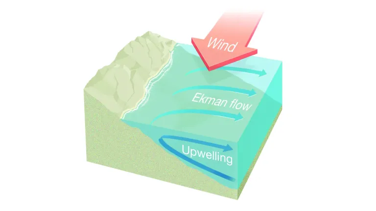
Winds blowing along the coast can lead to upwelling of colder water to the surface
Ekman transport in Australia
Upwelling is more likely along certain parts of the Australian coastline, particularly along New South Wales, south-east Queensland and the Bonney Coast in South Australia.
An important factor is the width of the continental shelf – the landmass that extends with a shallow gradient from the continent underneath the ocean.
Upwelling occurs when the continental shelf is narrow and the sea becomes very deep relatively close to the shore. The deeper water requires less time and energy to reach the coastline.
Headlands and bays along the coastline may also vary the effects from beach to beach.
If you look out to sea from the shore, the wind needs to be consistently blowing from left to right for upwelling to happen. This means:
- northerly or north-easterly winds for a long stretch of Australia's east coast
- south-easterly winds in the eastern Great Australian Bight.