Summary
Severe Tropical Cyclone Dinah is the strongest tropical cyclone to occur off the southern Queensland coast in recorded history. Fortuitously, it turned away from the coast as it reached K'Gari (Fraser Island) at category 4 intensity. Nevertheless, it impacted coastal areas from as far north as Yeppoon to the central New South Wales coast and then went on to impact Lord Howe Island and the North Island of New Zealand after transitioning into a mid-latitude low.
According to a study of insurance losses from Australian natural disasters from 1966-2017, Dinah caused nominal losses of $34 million translating to $5.1 billion in normalised (2017) losses. This ranks third on the list behind the 1998 Sydney hailstorm and Tropical Cyclone Tracy (1974).
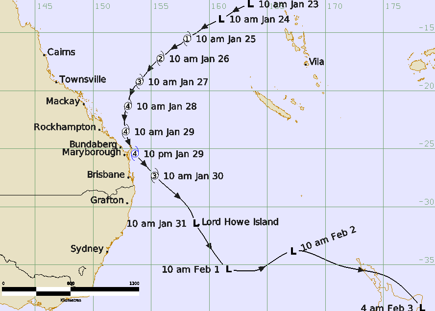
A tropical low developed in the Pacific Ocean on the 22-23 January and intensified as it moved southwest across the Coral Sea towards the Queensland coast. By 28 January it had turned towards the south, passing just east of Heron Island on the Great Barrier Reef on the morning of 29 January, and then to the south southeast as it passed over K'gari (Fraser Island) late on 29 January.
Sandy Cape Lighthouse recorded a minimum pressure of 944.8 hPa indicating that Dinah was at category 4 intensity. This makes it the most intense tropical cyclone to ever be recorded this far south off the Queensland coast.
Dinah then turned to the southeast further away from the coast and passed near Lord Howe Island and then into the Tasman Sea as an extra-tropical low. Tourists on Lord Howe Island were left stranded. Dinah transitioned into an extra-tropical cyclone to cause torrential rainfall and gales across the North Island of New Zealand.
Although Dinah remained offshore, the rainbands caused heavy rainfall and severe winds damaging areas between Rockhampton and Grafton. Houses were unroofed at Bundaberg, Maryborough and along the Sunshine and Gold Coasts. Banana and cane crops were wiped out on the Tweed Coast and a severe wind gust overturned a car at Evans Head.
One man drowned in floodwaters in Grafton when his car was swept away. In New Zealand in Rotarua a man went missing in floodwaters and was presumed to have drowned.
Huge seas and storm surge caused severe beach erosion from as far north as Yeppoon south to the central coast of New South Wales including offshore islands such as Heron, Lady Elliott and at K'gari (Fraser Is). At the Sunshine coast a storm surge of about 2 m inundated low-lying areas including cane farms at Bli Bli and around Noosa.More than 100 houses were flooded around Moreton Bay especially around Sandgate and Nudgee Beach. On the Gold Coast water lapped the decking of the Jubilee Bridge at Southport, about 1.5 m above highest astronomical tide. A section of the esplanade at Surfers Paradise collapsed. The surge on the Tweed River isolated Fingal (near Coolangatta) with six houses 'awash' with seawater. Severe coastal erosion extended into northern NSW.
This report is mostly based upon a reanalysis of the event by Jeff Callaghan of the Bureau in the early 2000s using all the available observations. Further analysis and documentation were completed in 2026.
For more information see the TC Dinah Report (doc).
Track and Intensity