Summary
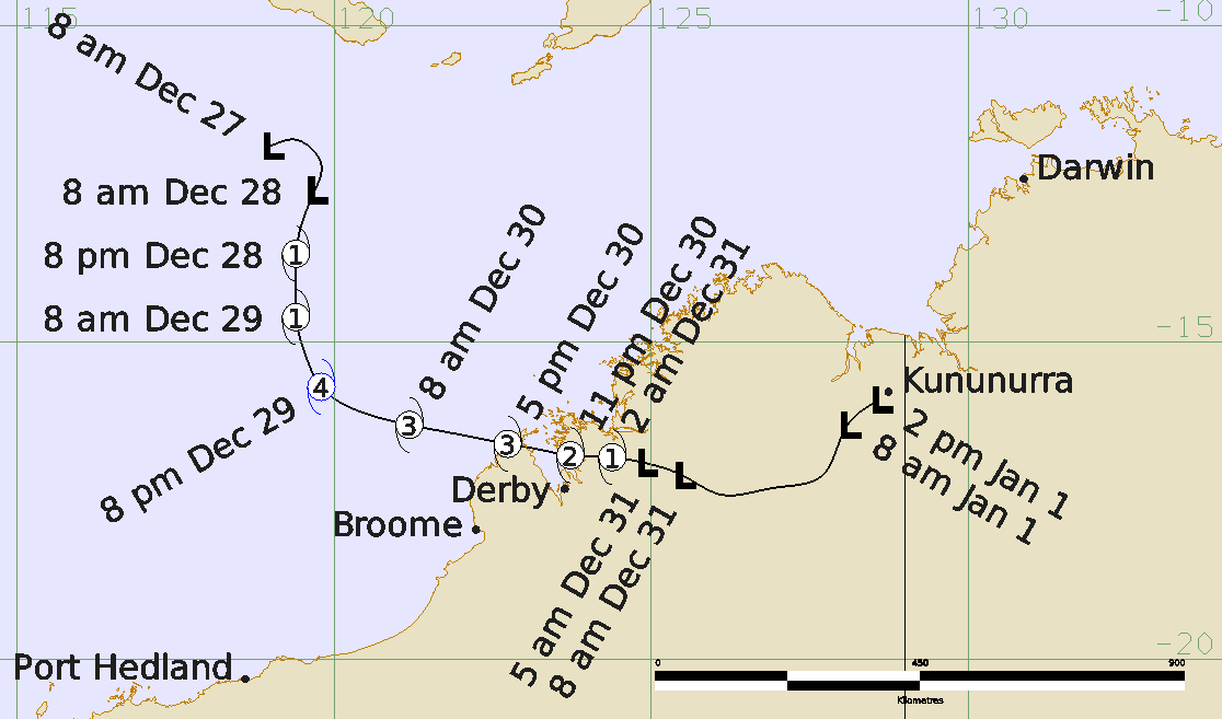
Severe Tropical Cyclone Hayley was a short lived but intense tropical cyclone that developed north of Broome in late December 2025 before crossing the tip of the Dampier Peninsula as a severe tropical cyclone.
A tropical low (08U) developed about 700 kilometres north northeast of Broome on 27 December and moved southwards. The low intensified into a tropical cyclone late on 28 December in a favourable environment. Hayley underwent rapid intensification and reached a peak intensity of Category 4 with estimated wind gusts up to 125 knots (230 km/h) near the centre at 1200 UTC (8 pm AWST) 29 December (AWST = UTC +8 hours), only 24 hours after it first reached tropical cyclone intensity.
On 30 December Hayley turned and moved on an east southeast path towards the Dampier Peninsula. It weakened slightly as it approached the coast and made landfall as a Category 3 system near the communities of Djarindjin and Lombadina at about 0900 UTC (5 pm AWT) 30 December. Hayley crossed King Sound and then moved inland north of Derby, weakening to below tropical cyclone strength at 2100 UTC on 30 December (5 am AWST on 31 December).
As it crossed the Dampier Peninsula, the cyclone caused damage to property and infrastructure including water ingress, trees and power lines down, and some roof damage. The highest wind gust recorded during the event was 85 knots (157 km/h) at 1013 UTC (6:13 pm WST) 30 December from Lombadina AWS. The highest daily rainfall totals recorded were 131.8 mm in the 24 hours to 2300 UTC 30 December (9 am WST 31 December) at Lombadina AWS and 182.2 mm in the 24 hours to 2300 UTC 31 December (9 am WST 1 January 2026) from Lansdowne as the remnants of Hayley moved over the eastern Kimberley. The Lansdowne total set a new January highest daily rainfall record for the station.
For more information see the TC Hayley Report (doc)
Track and Intensity