Summary
An unnamed tropical cyclone in February 1954, known as 'the Great Gold Coast Cyclone' was one of the most severe tropical cyclones to ever affect southeast Queensland and northern New South Wales. Tragically at least 34 people died, mostly as a result of floodwaters in northern New South Wales.
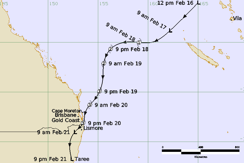
The tropical cyclone developed in the Pacific Ocean and intensified from 16-19 February as it moved southwest towards the southeast Queensland coast. South to southeasterly gales commenced about the southern Queensland coast on 19 February and late in the day the centre was analysed to be east of K'Gari (Fraser Island). The cyclone made landfall near Coolangatta on the Gold Coast at about 2200 AEST 20 February then moved into northern New South Wales and was moving south during 21 February.
Based on the observed pressures, it is probable that the cyclone reached at least category 3 intensity in the lead up and until landfall. Without satellite data it is impossible to determine the absolute peak of the tropical cyclone. The strongest winds are likely to have been over water and at exposed coastal sites such as on the east coast of Moreton and Stradbroke Islands just ahead of the cyclone. Brisbane City and Airport both recorded near gale-force winds in the southerly flow while higher winds were likely at the Gold Coast and adjacent northern New South Wales coast. A ship berthed at New Farm on the Brisbane River observed winds to 65 kn (120 km/h). Wind damage was reported from a wide area, being the most severe between the Gold Coast and Byron Bay. Gales are likely to have extended well south of the centre along the New South Wales coast.
Storm surge and wave action caused severe beach erosion across southeast Queensland and northern New South Wales particularly on the Gold Coast. Many jetties were destroyed and boats wrecked including at Byron Bay where 600 ft (183 m) of the outer section of the jetty was washed away taking with it most of the fishing fleet while the storm surge flooded parts of the town.
Heavy rainfall fell over a broad area in near coastal areas extending from the Queensland Sunshine Coast southward including most of the New South Wales coast. The heaviest falls were recorded in the Gold Coast hinterland (Springbrook Forestry 1047.5 mm) and northern New South Wales (Dorrigo 998.7 mm). Flooding was extensive and exacerbated following earlier heavy rains on 10-11 February.
The floods combined with storm surge on the Nerang River, described as being more than a mile-wide, to cause evacuations of families and a dramatic rescue of people from Macintosh Is.
Flooding in the Northern Rivers of NSW was devastating including on the Richmond River. Kyogle locals described it as a "wall of water" that claimed the lives of 10 people. During an attempted rescue at Casino, two men drowned when their motorboat hit a tree. The wall of water hit Lismore in the early evening, causing the river to swell up to 11 km wide in one place and a seven-year-old boy was swept away. One man drowned during a rescue at Murwillumbah.
At Armidale five people including a 21-month-old baby drowned after a car was washed into a flooded creek. Major flooding also affected Dorrigo, Grafton, Coffs Harbour, Hastings River, Macksville and Kempsey.
The historical context of this storm is examined in Callaghan (2023), Callaghan and Helman (2008), Granger and Hayne (2001) and Roche et al. (2013), the latter showing that had this event occurred in 2011, it would rank the third most expensive weather-related insurance loss in Australian history.
Note: This event occurred prior to the convention of naming tropical cyclones which formally commenced in 1964.
For more information see the Unnamed Gold Coast 1954 Report (doc).
Track and Intensity. Time in AEST (UTC+10 hours)