Summary
The unnamed tropical cyclone 09U was a small system that briefly reached tropical cyclone intensity as it passed over the Northern Territory coast east of Darwin on 9 January.
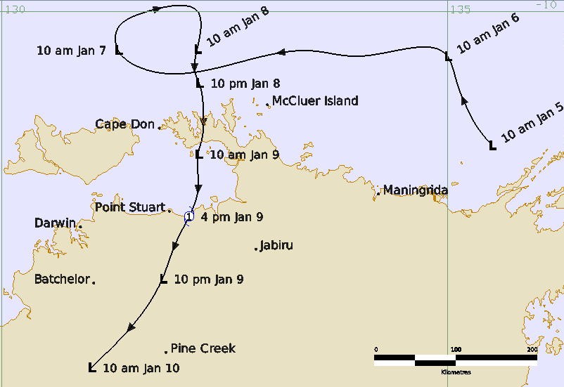
Tropical low 09U formed on 5 January off the east Arnhem Land coast of the Northern Territory. It moved west across the southern Arafura Sea on 6 January then slowed on 7 January. The weak circulation gained strength on 7-8 January as a monsoon surge combined with a short-wave upper trough to the south to improve organisation of deep convection. The low turned to the south on 8 January moving across the Cobourg Peninsula overnight and then into Van Diemen Gulf on 9 January.
The system intensified further to be a tropical cyclone intensity on 9 January prior to crossing the coast at around 1530 ACST (0600 UTC) near the Alligator Rivers Region, just east of Point Stuart. In the hours prior to landfall, Berrimah (Darwin) radar indicated the formation of a core region around 50 km diameter with an eye feature around 20 km across.
Gales are estimated to extend more than halfway around the centre for about six hours between 0930-1830 ACST (0000 - 0900 UTC) 9 January, satisfying the Australian definition of a tropical cyclone.
The system moved to the south southwest over land and winds gradually eased, and then during 10 January became difficult to identify on radar west of Katherine.
The only significant wind impact was to vegetation in the area near landfall point including some felled trees along the Point Stuart Road. The main impact was heavy rainfall and associated flooding along the north coast and in the Jabiru area on 9 January, extending to the Katherine region on 10 and 11 January. At Katherine, continuous rain fell from the evening of 10 January into the morning of 11 January (24-hour totals to 0900 ACST 11 January: 250-300 mm, highest total 325 mm at Dorisvale Crossing). The Katherine River rose sharply by 13 m, peaking at 14.9 m at 1130 ACST (0200 UTC) 11 January. The Stuart Highway was cut north of Katherine and many local roads were flooded. Flood waters continued downstream into the Daly River from 14 January, which peaked on 21 January at 12.8 m at Daly River Police Station, isolating the Nauiyu (Daly River) community.
During operations the system was not named a tropical cyclone, but a post-event review assessed that this system reached tropical cyclone intensity.
For more information see the Unnamed 09U Report (doc).
Track and Intensity. Time in ACST (UTC+9.5 hours)