
Fire weather information
Our fire weather services
Our fire weather services help you understand fire risk and make informed decisions during fire season. They include:
- fire weather warnings, when forecast conditions are likely to be dangerous
- fire danger ratings, in consultation with fire agencies
- fire danger products, such as detailed forecasts and outlooks for fire agencies and other organisations
- wind change charts for south-eastern Australia during elevated fire danger periods.
Check fire weather information for your location
Fire weather warnings
View Warnings and alerts.
Fire danger ratings
- Search for your location on this website in Forecasts and observations or in the BOM Weather app.
- On the location page, the fire danger rating is shown with the district forecast (when available).
- You can also view fire danger ratings for all districts across your state or territory. See Find district fire danger ratings and FBI on this page.
Total fire bans
Fire agencies in each state and territory are responsible for total fire bans. Check with your state or territory fire agency for any current fire bans or other restrictions. Find their details using the National Emergency Management Agency website.
About fire weather warnings
We issue fire weather warnings:
- based on fire weather districts
- when forecast conditions are likely to be dangerous
- in the afternoon for the following day
- early in the morning for the current day.
We review warnings regularly and reissue them as needed. View Warnings and alerts.
When fires are likely:
- stay in touch with your state or territory emergency services – find details through the National Emergency Management Agency website
- tune into emergency broadcasters
- keep up to date with the fire weather warnings by checking this website or getting fire weather notifications from the BOM Weather app.
Fire danger rating scale and system
Fire danger ratings indicate how difficult it will be to control or suppress a fire. State and territory fire agencies set fire danger ratings based on weather, and other conditions they consider relevant. This includes:
- temperature
- humidity
- wind
- rain
- fuel conditions.
Fire danger ratings scale
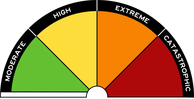
There are 4 levels in the Australian fire danger ratings, with actions at each step:
- Moderate – plan and prepare.
- High – be ready to act.
- Extreme – take action now to protect life and property.
- Catastrophic – for your survival, leave bushfire risk areas.
The scale also includes 'No rating', shown as a white bar, when no proactive action is required by a community. Fires may start on 'no rating' days but they are not likely to move or act in a way that threatens community safety.
For more information, view the Australian Fire Danger Rating System website.
About the fire behaviour index
The fire behaviour index (FBI) is a scale of potential fire behaviour. It ranges from zero to 100 and beyond. Higher values mean more dangerous fire behaviour and greater fire danger risk.
Fire agencies use the FBI to inform decisions about the fire danger rating for a district. They also take into account information about other conditions.
Calculating the fire behaviour index
We use mathematical models to predict potential fire behaviour characteristics, based on weather and fuel information. For example, the models can predict:
- fire intensity
- flame height
- rate of spread
- spotting potential.
There are models for the 8 major vegetation types:
- buttongrass
- grassland
- savanna
- forest
- mallee heath
- pine
- heathland
- spinifex.
These include many sub-vegetation types. This enables fire behaviour indices to account for local variations that affect fire risk.
The models calculate the FBI number for a district based on predicted fire intensity or rate of spread. This informs the fire danger rating for that district.
Fire behaviour index links to fire danger ratings
The index has number ranges (categories) that align with the fire danger ratings scale. See 'FBI categories for fire danger ratings' on this page.
The FBI number for a district usually indicates its fire danger rating. However, fire agencies may set a different rating based on local conditions and other factors they consider relevant.
This means the fire danger rating reflects expected fire behaviour. It supports organisations making operational decisions about, for example:
- fire preparedness, including community safety messages and advice
- prescribed burning
- bushfire suppression.
FBI categories for fire danger ratings
| Index number range (category) | Fire danger rating |
|---|---|
| 0 to 11 | No rating |
| 12 to 23 | Moderate |
| 24 to 49 | High |
| 50 to 99 | Extreme |
| 100-plus | Catastrophic |
Find district fire danger ratings and FBI
See forecast fire behaviour index and fire danger ratings for districts in your state or territory:
Service level specification for fire weather
This document describes our publicly available fire weather services and the additional services we provide to support emergency management.