
We are all impacted by rain, whether it's deciding to hang the washing out, hosting an event or getting to school pick-up.
Rainfall is one of the most important things we forecast for the Australian community. But it's also the hardest to get right.

Industries like aviation, agriculture and emergency management rely on accurate rainfall forecasts to make critical decisions
Why is rainfall so hard to forecast?
Temperature and wind are often similar across large areas, but rainfall can be very different from one place to another. From suburb to suburb, or farm to farm, showers can move across the landscape, dumping heavy rain on some areas while completely missing other areas.
Our meteorologists assess complex computer models to identify areas where rain is possible. In some weather situations, we can do this with a high level of accuracy. But at other times, knowing exactly when and where the rain will fall can be less certain, particularly when thunderstorms are part of the forecast. It's a bit like popping corn – we can see the corn heating in the pot, but we can't predict precisely which kernel will pop first or when it will pop.
The type of rain, local geographic features and changes in atmospheric conditions can mean a rain-bearing system develops or tracks in a different direction than expected. These changes can be small compared to the overall scale of the weather system. But they can significantly influence where and how much rain falls and be a key reason rainfall varies from the forecast.
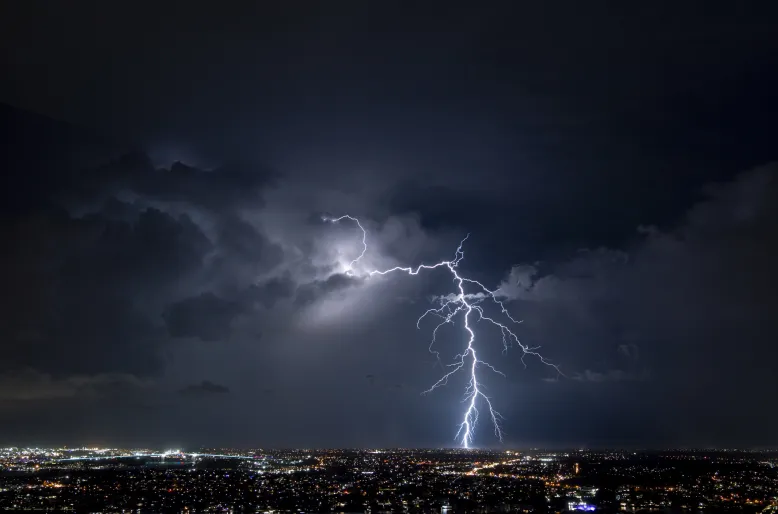
Thunderstorms – like this one over Brisbane, Queensland – can make predicting exactly when and where rain will fall particularly difficult
Why is the rainfall forecast given as a range instead of one number?
We use probability to present rainfall forecasts because of the uncertain and highly variable nature of rain.
Rather than giving a single amount of how much rain will fall, the rainfall range reflects the most likely outcomes based on the information available. This gives a better understanding of what conditions to plan for, such as taking an umbrella, planting crops or pouring concrete.
To forecast rainfall, the bureau runs many different weather scenarios through our supercomputer. When those scenarios align, we have greater confidence in the forecast. When they show different outcomes, there is more uncertainty about where and how much rain will fall – and this is reflected with a larger forecast range for your location.
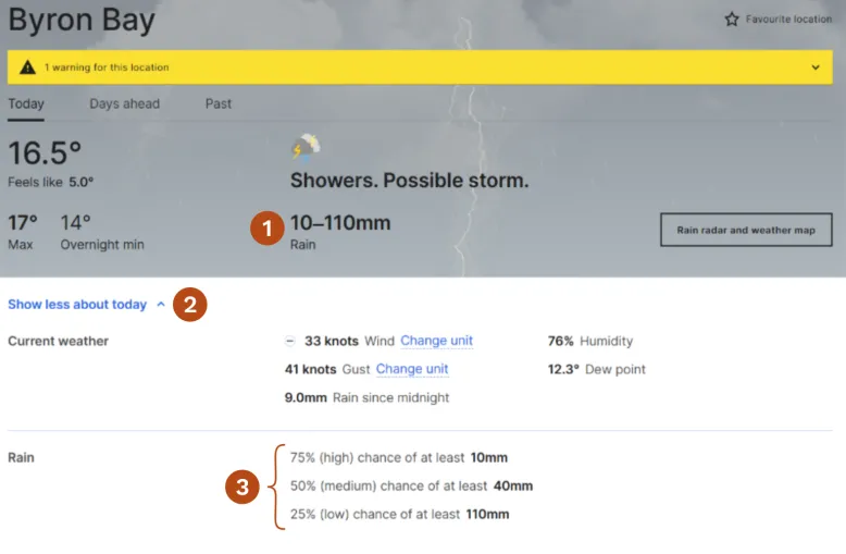
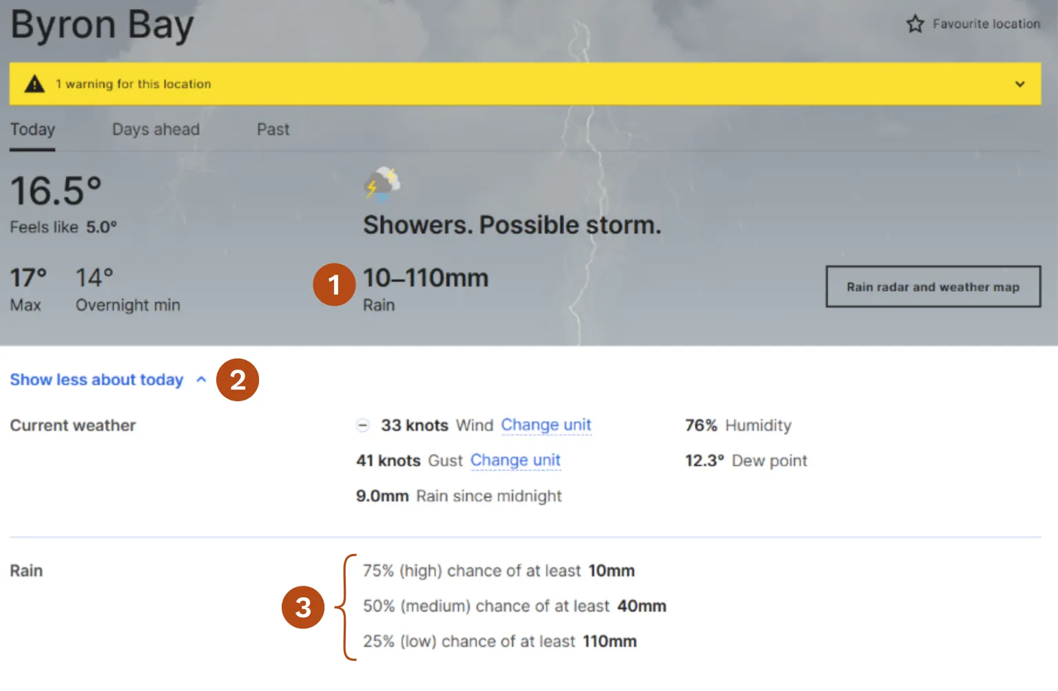
The forecast for Byron Bay shows a 75% chance of at least 10 mm of rain and a 25% chance of at least 110 mm of rain (1). In the expanded 'Show more about today' (2) section, the Rain row (3) displays the low, medium and high chance of rain forecast amounts.
Why does the rainfall forecast change?
A forecast is our best prediction based on the information available at the time. In general, the closer we are in time to the forecast period, the greater the accuracy. Our forecasts for the next day are more accurate than the 7-day forecasts.
As time passes, new observations from satellites, weather stations, radars and upper-atmosphere monitoring systems are fed into computer models and become available to our forecasters. These updated observations can change how weather systems are expected to develop and move.
The atmosphere also changes less over short periods, so there is less opportunity for uncertainties to grow and diverge from the forecast. As confidence in a particular scenario increase, a human forecaster can add their expertise. This includes knowledge of local topographic effects, converging winds and model biases.
We monitor Australia's weather 24 hours a day, 7 days a week, 365 days a year. Forecasts are regularly updated as new information becomes available.
How do rainfall measurement sites vary from forecast locations?
To predict the weather for your location, we first draw on observations from a range of assets, including satellites, upper atmosphere monitoring and automatic weather stations, to get a full picture of what the weather is doing at the moment.
Our forecast model uses this data to generate thousands of unique forecasts for 6 km by 6 km grid squares across Australia (watch a short weather model grids video). The forecast you see for your location is from the 6 km grid containing your town or location – we call this the ‘point forecast’.
Real-time rainfall observations are reported on our website and app from a single location, usually from an automatic weather station (AWS). That AWS may not be located within the same forecast grid as your location and may even be many kilometres away.
As a result, it's normal to see differences between the forecast and the latest observed weather. Forecasts describe the most likely conditions for the forecast grid, while observations reflect conditions recorded at a single point. This can be particularly important for rainfall, which can vary dramatically over short distances.
If you want to know where the observations for your location are coming from go to our website, navigate to your location page then click 'past'. On the BOM Weather app, go to your location and scroll down to the 'Last updated' information (you may need to tap the information icon).
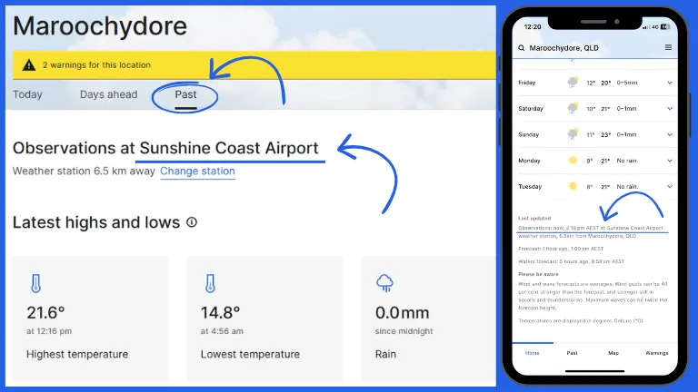
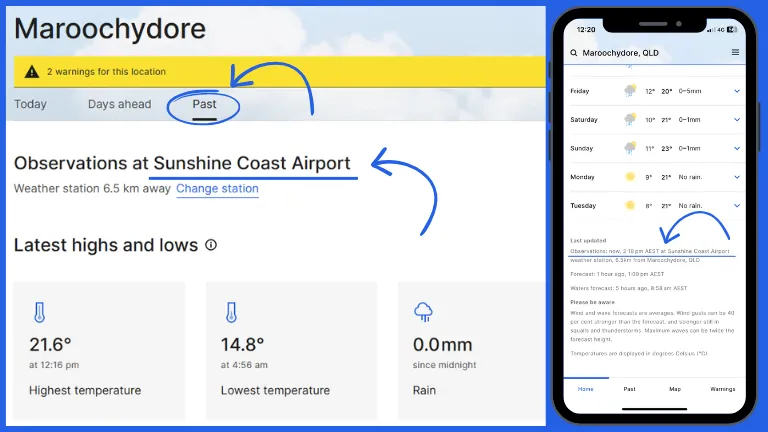
Real-time observations displayed for Maroochydore come from the Sunshine Coast Airport weather station
Why do different apps show different rainfall forecasts?
The bureau is Australia's national weather, water, climate, ocean and space weather information agency. Many other weather providers rely on the data from our observation network and forecast models to prepare their forecasts. But they may combine this with different computer models, forecasting techniques and update schedules. Forecasts may also be generated for slightly different locations, time periods or grids. This means 2 different weather apps could display different rainfall amounts, even when forecasting for the same town.
The forecasts displayed on our website and app are prepared by our meteorologists who use their understanding of Australia's unique weather patterns and local conditions to interpret the data and advanced weather modelling. Sometimes, you may notice differences between our website and app.
Will we get it right all the time?
The short answer is no.
Weather forecasting has improved dramatically over time thanks to advances in science, technology, observations and computing power.
But the atmosphere is a complex and chaotic system. Small differences in current conditions can lead to very different outcomes days later. So, there will always be some level of uncertainty when predicting weather, especially rainfall.
That's why forecasting isn't just about producing numbers. It's also about communicating uncertainty and helping people understand the range of possible outcomes, so they can plan their day accordingly. One of the most important roles of a meteorologist is turning highly complex weather information into a clear and useful story.
We work closely with emergency services all year-round, supporting them to prepare and respond to hazards and severe weather events that impact the community. Our meteorologists also tell more of the story behind the weather on regular radio, TV and online interviews and on our social media channels, so you can learn how changes in a weather system might impact the forecast for your location.