
Who is responsible for flood warnings?
The Bureau of Meteorology is responsible for providing riverine flood warning services to Australia's states and territories. To keep communities safe, the bureau:
- provides an Australia-wide service, as part of the total flood warning system
- issues official weather warnings direct to the community through our website and the BOM Weather app
- shares flood warnings with local radio stations that are emergency broadcasters, including the Australian Broadcasting Corporation (ABC).
State and territory emergency services, and sometimes local councils, use our flood warnings to issue community safety warnings. These warnings explain the likely impacts and what actions to take.
In summary:
- bureau flood warnings tell you what the river is likely to do
- state emergency service (SES) warnings tell you what actions to take.
Follow all advice from your local emergency services before, during and after severe weather.
Stay up to date
- Find the latest flood watches and warnings on our Warnings and alerts page or the BOM Weather app.
- Check your local rainfall and river conditions to know what is happening as conditions change.
To get warnings direct to your phone, download:
- the BOM Weather app and set notifications for your location, and
- your local state or territory emergency app. Find details on the National Emergency Management Agency website.
Australia's total flood warning system
Australian, state, territory and local governments all help deliver Australia's flood warning system. We work together to assess information, understand flood risks and keep communities informed.
About riverine flood watches and warnings
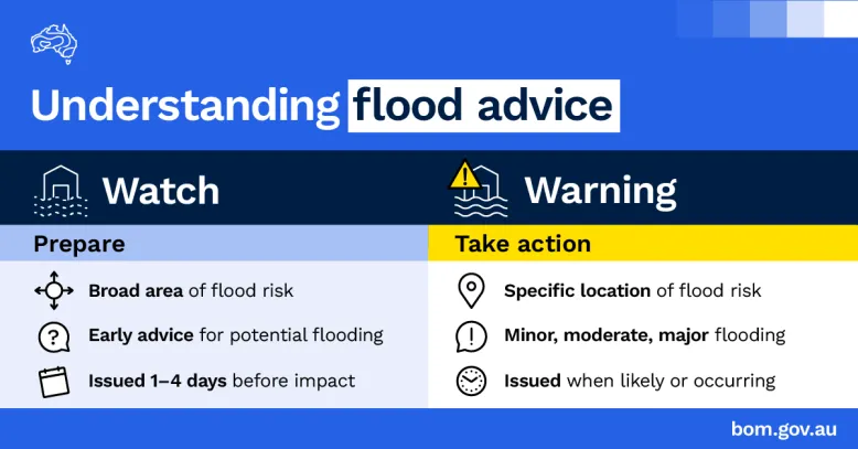
We give as much warning time as possible when riverine flooding is expected. We issue 2 main types of flood advice based on the latest information:
These may contain forecast information. Learn more about the 3 types of forecast information in our warnings on the Forecasting floods page.
Video: Understanding Flood Watches and Flood Warnings
There are different types of floods which have different warning levels to help you prepare and act according to the information that we provide.
Our flood warnings are issued as:
- a Flood Watch
- a Flood Warning
- or a Severe Weather Warning.
Riverine flooding occurs when rainfall saturates a catchment and excess runoff moves into waterways, causing river levels to rise. When this is likely, we issue a Flood Watch for the impacted area. This gives you early advice that riverine flooding may occur – so you can prepare. This isn't a warning of imminent flooding.
When flooding is imminent or already occurring, we issue a Flood Warning. This means you should take action – and follow the advice of your local emergency services. Sometimes, we can also experience short bursts of intense rainfall which can lead to rapid-onset flooding – known as flash flooding. When flash flooding is likely, we issue a Severe Weather Warning for the impacted area.
We'll issue a Flood Watch up to 4 days before flooding is expected. This is because a Flood Watch is based on forecast rainfall. We update Flood Watches at least once per day. In most areas, we keep the Flood Watch in place until the areas included are covered by a Flood Warning – or the risk of flooding has passed.
Not all areas that receive a Flood Watch will receive a Flood Warning. An area may experience flooding without a Flood Watch being issued. A Flood Watch covers a broad region. Sometimes we know there will be a lot of rain coming but we can't determine exactly where that will fall. Therefore, not every location within the Flood Watch will experience flooding. A Flood Warning will cover a more specific area, when we become more certain that flooding is expected.
A Flood Watch provides important information about:
- forecast rainfall totals
- developing weather conditions
- the catchments at risk of flooding
- if roads and communities may be affected
- and how to get flood safety advice from your local emergency services.
We work closely with emergency services in each state and territory, providing information to help with flood preparedness, response and recovery. For information on how to prepare for a flood emergency – visit your State Emergency Service website.
For emergency help in a flood – call the SES in your state on 132 500.
And in a life-threatening flood emergency call 000.
For more information about floods – visit the flood knowledge centre on our website. Stay up-to-date with the latest forecasts and warnings in your area via the Bureau website or the BOM Weather app.
What is a flood watch?
A flood watch gives early notice that flooding is possible in an area. We issue a flood watch up to 4 days before riverine flooding may occur. We base it on:
- weather and rainfall forecasts
- how wet the river catchment already is.
A flood watch does not mean flooding is about to happen. It gives you time to prepare in case flooding occurs.
What information is in a flood watch?
A flood watch may include information about:
- areas or river catchments that may be affected by flooding
- if the flood level is likely to exceed minor, moderate or major
- weather forecasts
- other warnings, flood information and emergency service contact.
We provide flood watches to emergency management agencies to support planning and preparedness. We also provide them to the community on this website and the BOM Weather app.
Updates to flood watches
We generally update flood watches at least once a day. We finalise a flood watch for an area when:
- it is replaced by flood warnings, or
- the risk of flooding has passed.
What is a flood warning?
A flood warning tells you that riverine flooding is likely or already happening at a specific location.
Flood warnings provide more detail than flood watches. They help you prepare and act by:
- identifying the time and place where flooding is expected
- naming affected catchments, rivers and locations
- forecasting the likely flood level – and if the flood level is likely to exceed minor, moderate or major.
Weather can change quickly and rivers can rise rapidly after heavy rainfall. Sometimes there is not enough time to issue a:
- flood warning ahead of riverine flooding
- flood watch before a flood warning.
What information is in a flood warning?
Bureau flood warnings can vary and may include:
- the latest rainfall and river height observations
- expected flood levels at specific locations, and if it is likely to exceed minor, moderate or major
- forecast peak river heights at some locations
- when flooding is expected to occur
- if the rainfall is likely to continue or has eased.
River levels can vary across the floodplain. Find out more about flood classifications and river heights.
We send flood warnings to emergency management agencies to help them plan and respond to flooding. We also publish flood warnings on our website and the BOM Weather app.
Updates to flood warnings
We update forecasts and warnings when new information becomes available or when the flood risk changes. During rapidly changing flood events, warnings may be updated as often as every 3 hours. When conditions are changing more slowly, updates may be issued less frequently, with some warnings updated every few days.
Stay informed
Every flood is different. To keep up to date with the latest forecasts and warnings:
- download the BOM Weather app and set notifications for your location
- check local rainfall and river conditions
- find the latest flood watches and warnings on our Warnings and alerts page
- download your local state or territory emergency service app.
Always follow advice from your local emergency services before, during and after a flood.
How much warning time for floods?
We aim to provide riverine flood watches and warnings early enough for communities to prepare and act.
Target lead times
A target lead time is the minimum amount of time between a warning being issued and the river meeting the expected flood level. This time can help you prepare and stay safe.
Target lead times are set out in the service level specifications for floods. They are agreed with state and territory emergency services.
We aim to meet the target lead time whenever possible. However, during extreme or unusual weather, there may be less warning time.
For example, if a location has a target lead time of 12 hours for minor flooding, we aim to issue a warning at least 12 hours before the river is expected to be at that level.
Target lead times can vary between locations because rivers respond differently to rainfall. Many factors can affect how quickly river levels rise. These include rainfall intensity, river size, landscape, soil type, land use and infrastructure.
Warning about flash flooding and coastal inundation
Flash flooding
Flash flooding can happen suddenly, often with little or no warning.
State, territory and local governments are responsible for providing flash flood warnings. They may issue warnings in some locations:
- when flash flooding has been confirmed
- to support bureau warnings for severe thunderstorms or severe weather.
We issue severe weather and severe thunderstorm warnings when heavy or intense rainfall is forecast or occurring that may cause flash flooding.
Learn more about the difference between flash flooding and riverine flooding on the About floods page.
Coastal inundation (flooding)
We issue warnings for storm tides, tsunamis and coastal hazards that may lead to coastal inundation (flooding). Coastal hazard warnings include abnormally high tides and damaging surf.
Learn more about coastal hazard warning services.
Service level specifications for floods
Details of our flood services are set out in the service level specifications (SLS) documents for each state and territory. This includes:
- the river catchments and locations covered by the service
- river levels that prompt flood watches and warnings
- target lead times
- the types of flood forecasts, warnings and services provided
- rainfall and river monitoring sites that support the flood warning network including their priority level (high, medium or low) – based on the impact of an outage on the flood warning service.
These service levels are developed with state and territory agencies, local councils, emergency services, catchment management authorities and water authorities.
Maintaining and improving the flood warning network
More than one source
We monitor rainfall and river conditions using information from many sources, including:
- more than 10,000 rainfall and river gauges across Australia
- satellite observations
- weather radar data.
Severe weather can sometimes damage gauges and interrupt data collection. This is one reason we use multiple sources of information and do not rely on any single system for flood forecasting.
We combine data from gauges, satellites, radar, flood models and forecasting tools. This helps keep the flood warning service operating when some equipment is unavailable.
The bureau owns more than one-third of Australia's flood monitoring gauges. The rest are owned by state, territory and local governments, and private organisations.
Maintenance and improvement
We regularly maintain, repair and upgrade our monitoring network. Learn more about flood, river and rain gauges and the role of field technicians.
We work with state agencies and local councils to improve flood warning services by upgrading the flood monitoring network. Projects include:
- upgrading rain and river level gauges
- installing new equipment in priority locations
- delivering the National Flood Warning Infrastructure Network (FWIN) Program, a 10-year program in critical catchments across Australia.