


Daly: Region description
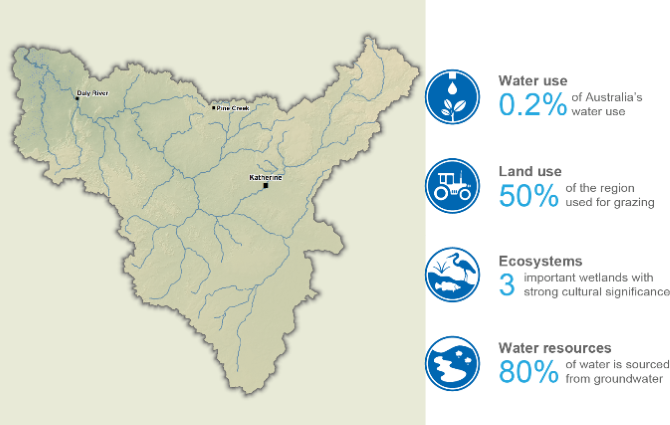
- The Daly region, located in the Northern Territory, is defined by the Daly River catchment and is one of the few areas in northern Australia with perennial rivers sustained by groundwater discharge.
- These interconnected groundwater and surface water systems support rich environmental values, strong Aboriginal cultural connections, and recreational use across the region.
- Water use is comparatively small at the national scale, with the majority sourced from groundwater to support agricultural production, particularly beef cattle grazing.
This section provides an overview of the Daly region, including its population, land use, topography, culturally and environmentally significant areas, and water resources, as well as its water management arrangements and water rights provisions.
For further information, scroll down this page or click on the links below:
Geographic information
General description
Area: 53,708 km²
Population: 11,575 (Australian Bureau of Statistics (ABS) 2021 - Daly Region*)
*Includes Daly SAL 2 and Katherine SAL 2
Note: There's no definitive area on ABS which matches the Daly region
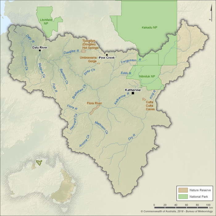
Figure R1 Contextual map of the Daly region
- The Daly region is located in northern Australia, within the Northern Territory, and is defined by the Daly River surface water catchment.
- Groundwater is the dominant water resource in the region, accounting for about 80% of total water sourced.
- Aquifer discharge sustains dry season flows in many rivers, underpinning strong groundwater–surface water connections which supports significant environmental, cultural, and recreational values.
- The region accounts for only 0.2% of Australia’s total water use, with most extractions drawn from groundwater for agricultural purposes.
Land use
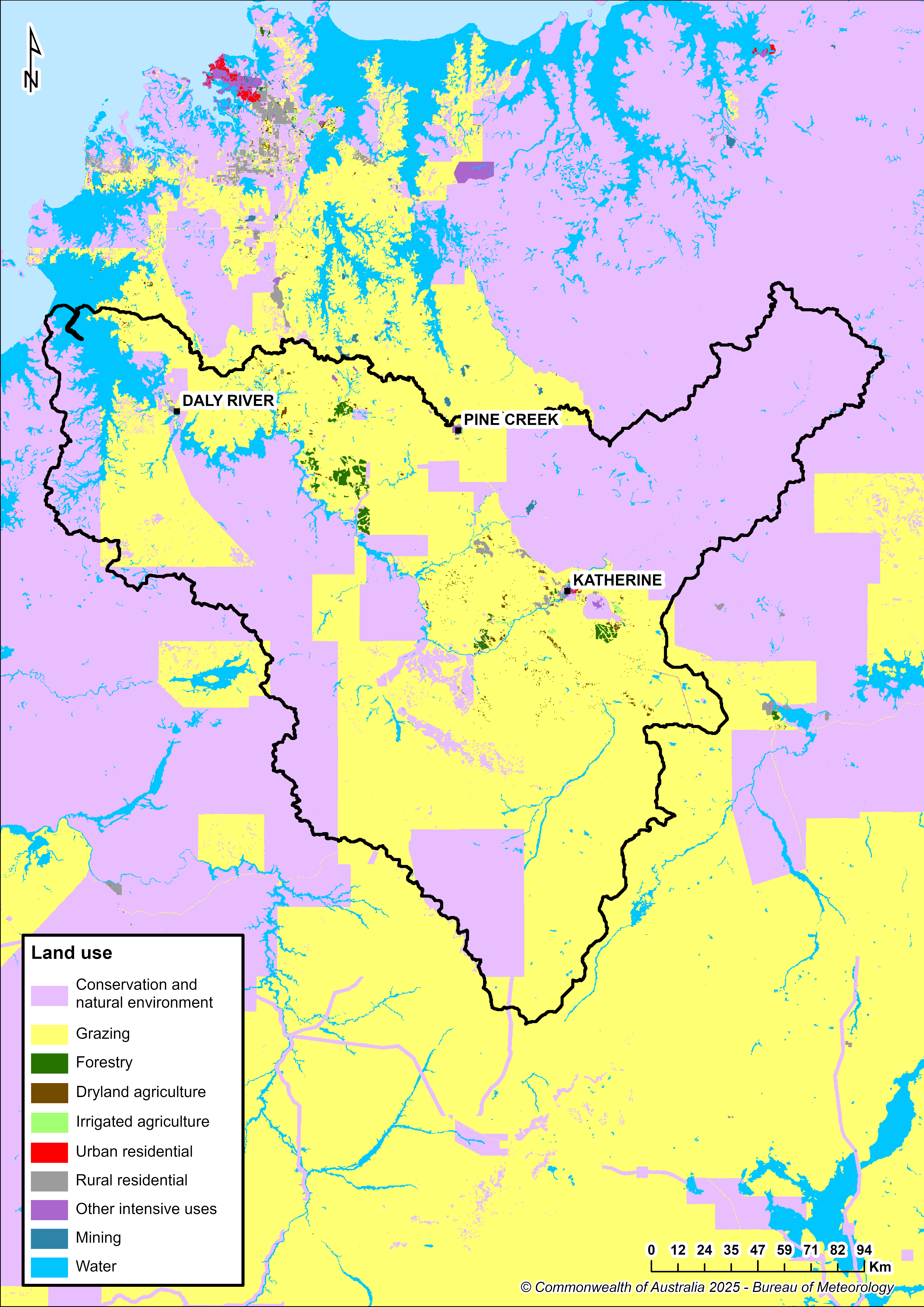
Figure R2 Land use in the Daly region
- Pastoralism, primarily beef-cattle grazing, dominates the Daly region, occupying just over half of its land area.
- Conservation and natural environments cover approximately two-fifths of the region, encompassing several nature reserves—including Cutta Cutta Caves and Umbrawarra Gorge—along with national parks such as Nitmiluk National Park and the southern portion of Kakadu National Park.
- The town of Katherine serves as the region’s main population centre; other notable communities include Pine Creek and Daly River (Nauiyu).
Significant aquatic ecosystems
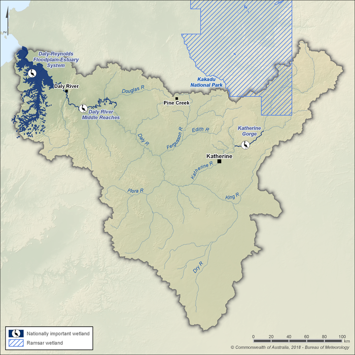
Figure R3 Significant wetlands in the Daly region
- Kakadu National Park is a Ramsar-listed wetland of international importance located about 220 km east of Darwin, with its southern portion extending into the north-eastern part of the Daly region.
- Spanning almost two million hectares across the Northern Territory, Kakadu meets all nine Ramsar criteria and is recognised under the World Heritage Convention for its outstanding natural and cultural values, supporting one of the most diverse freshwater ecosystems in northern Australia.
- The Ramsar site is a mosaic of interconnected wetlands, including sandstone plateau communities, escarpments, extensive seasonal floodplains, estuaries, tidal flats, and offshore islands. It supports numerous nationally threatened species such as the yellow chat, pig-nosed turtle, speartooth shark, northern river shark, and flatback turtle.
- Beyond Kakadu, the Daly region also contains three nationally important wetland systems identified by the Northern Australia Sustainable Yields Project: the Daly–Reynolds floodplain–estuary system, the Daly River middle reaches, and the Katherine River Gorge (as shown in Figure R3).
- These wetlands act as vital dry-season refuges for waterbirds, sustaining species such as magpie geese, herons, and allied species.
- The Daly River supports more than 90 freshwater fish species, eight of the nine freshwater turtle species found in the Northern Territory, and three threatened elasmobranch species.
- Groundwater-fed baseflows and seasonal floods sustain aquatic vegetation and food webs, supporting species such as barramundi, sooty grunter, and the largest known population of pig-nosed turtles in Australia.
Significant Aboriginal cultural places
- The Daly region holds deep cultural and spiritual significance for Aboriginal peoples, with many important places and stories directly connected to its rivers, wetlands, springs, and groundwater systems.
- At least 12 discrete groups of Aboriginal people have traditional lands within the Daly region, highlighting the diversity of custodianship across the landscape. For these communities, water is sacred, elemental, and deeply symbolic of life-giving vitality.
- Dreamtime narratives frequently describe water as “living” or life-giving. In Wardaman mythology, the Rainbow Serpent is an ancestral being believed to shape watercourses and drive the monsoon cycle through its creative powers.
- Rivers, billabongs, springs, and groundwater-dependent ecosystems across the Daly region serve as cultural and ceremonial focal points. The Daly River functions as a significant ceremonial track, with many sacred sites anchored in the physical landscape—formed through the actions or transformations of Dreamtime beings.
- The Wardaman Indigenous Protected Area (IPA) spans almost 225,000 hectares within the Upper Daly and Victoria River catchments. It contains extensive rock-art archives, with more than 200 painted sites and over 41,000 engravings associated with waterholes, springs, and other features that hold cultural, navigational, and spiritual importance.
- Through projects such as the Northern Territory’s Cultural Water Needs initiative, Wardaman Traditional Owners and Rangers are documenting and measuring the water requirements of culturally important sites, including the Flora River and other springs. This work helps ensure these places, and their cultural values, are sustained across seasonal cycles.
Water resources
- The Daly region’s water resources consist of both groundwater and surface water, which are strongly interconnected. Groundwater aquifers discharge into many rivers, maintaining dry-season flows and supporting healthy ecosystems.
- Groundwater is the dominant source of water use in the region, acounting for about 80% of the total water sourced. It is primarily extracted for agricultural production, particularly irrigated cropping and pastoral activities.
- Surface water plays a critical environmental role, sustaining perennial rivers, wetlands, and culturally significant sites, and providing habitat for diverse aquatic species. Regulated use of surface water is comparatively limited.
- Together, groundwater and surface water underpin the region’s environmental, cultural, agricultural, and recreational values, making their interaction central to Daly’s water management.
Groundwater
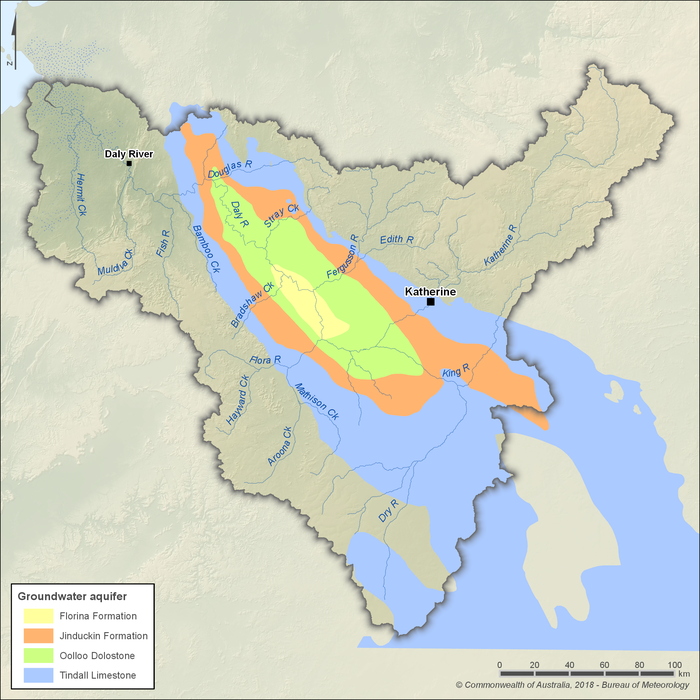
Figure R4 Groundwater aquifers in the Daly region
- Groundwater is the dominant water resource in the Daly region, accounting for approximately 80% of all water sourced.
- The Daly Basin contains four main aquifers: Oolloo Dolostone, Tindall Limestone, Jinduckin Formation, and Florina Formation (shown in Figure R4).
- Extractions are concentrated in areas underlain by the Oolloo Dolostone and Tindall Limestone aquifers, where fractured and cavernous structures store large volumes of water and allow high-yield extraction for agriculture, stock, and town supply.
- In many areas, the Tindall Limestone is confined by the overlying Jinduckin Formation and parts of the Oolloo Dolostone, limiting recharge. It is replenished only where exposed at the surface (e.g. near Katherine) or through river losses (as illustrated in Figure R5).
- Composed mainly of siltstone, the Jinduckin Formation is largely impermeable, while the Florina Formation is the youngest and smallest aquifer, used only for limited local supply.
- Discharge from these aquifers is critical for sustaining perennial flow in the Daly River and its tributaries during the dry season, directly linking groundwater extraction to the health of surface water systems.
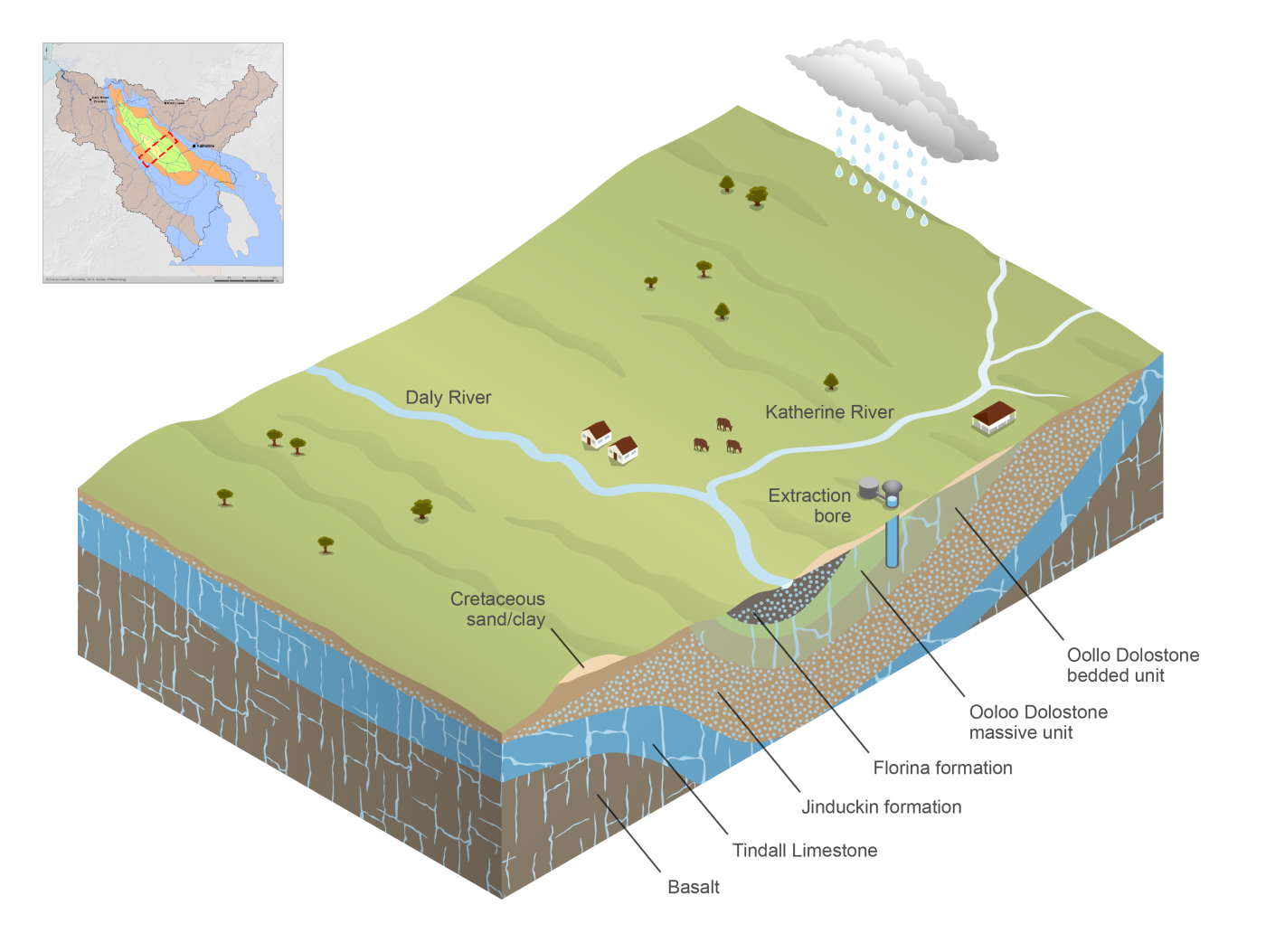
Figure R5 Cross-section diagram of groundwater aquifers in the Daly region
Surface water
Rivers
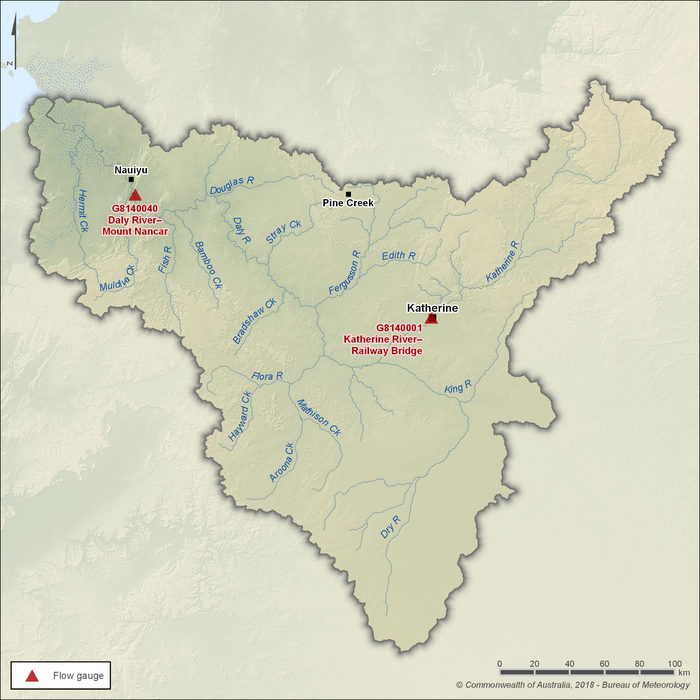
Figure R6 Gauging stations along the Katherine and Daly rivers within the Daly region
- The Katherine and Daly rivers are the two primary river systems in the Daly region, with the Katherine River acting as the main tributary to the Daly River—one of the largest river systems in the Northern Territory.
- Flow monitoring is undertaken at two key gauging stations: Katherine River at Railway Bridge (Station G8140001) and Daly River at Mount Nancar (Station G8140040), which represent seasonal flow patterns across the region.
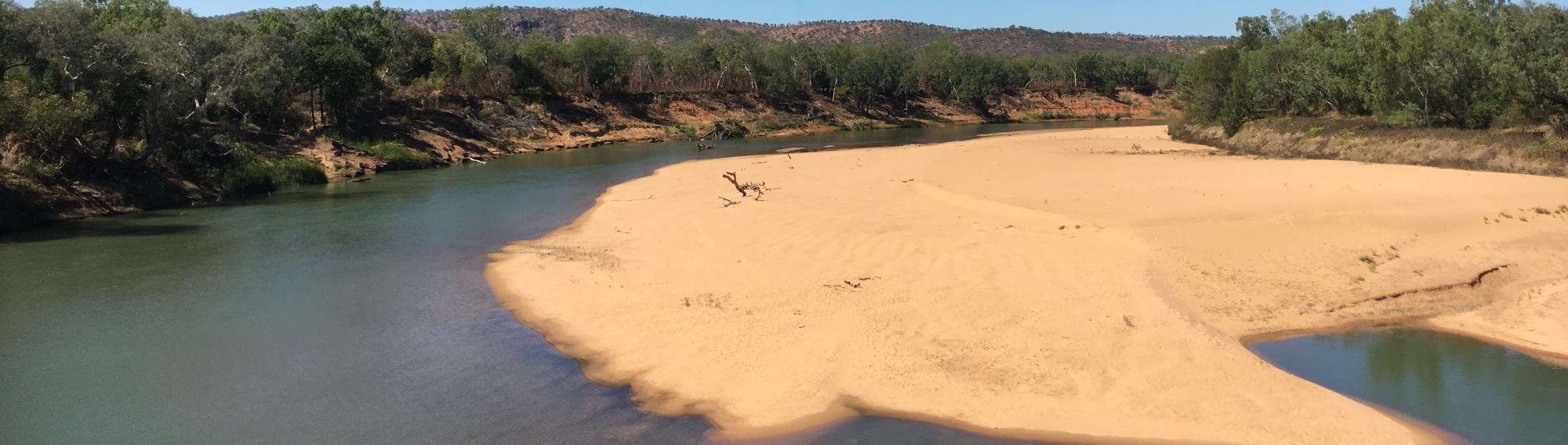
- Although flows are strongly influenced by annual rainfall, the Daly River is one of the few perennial rivers in northern Australia. Its year-round flow is sustained by groundwater discharge from the Oolloo Dolostone and Tindall Limestone aquifers, which are separated by the Jinduckin Formation aquitard (see Figure R4 above).
- These perennial surface flows support aquatic ecosystems, cultural values, and recreational uses, making the rivers central to both the environment and community life.
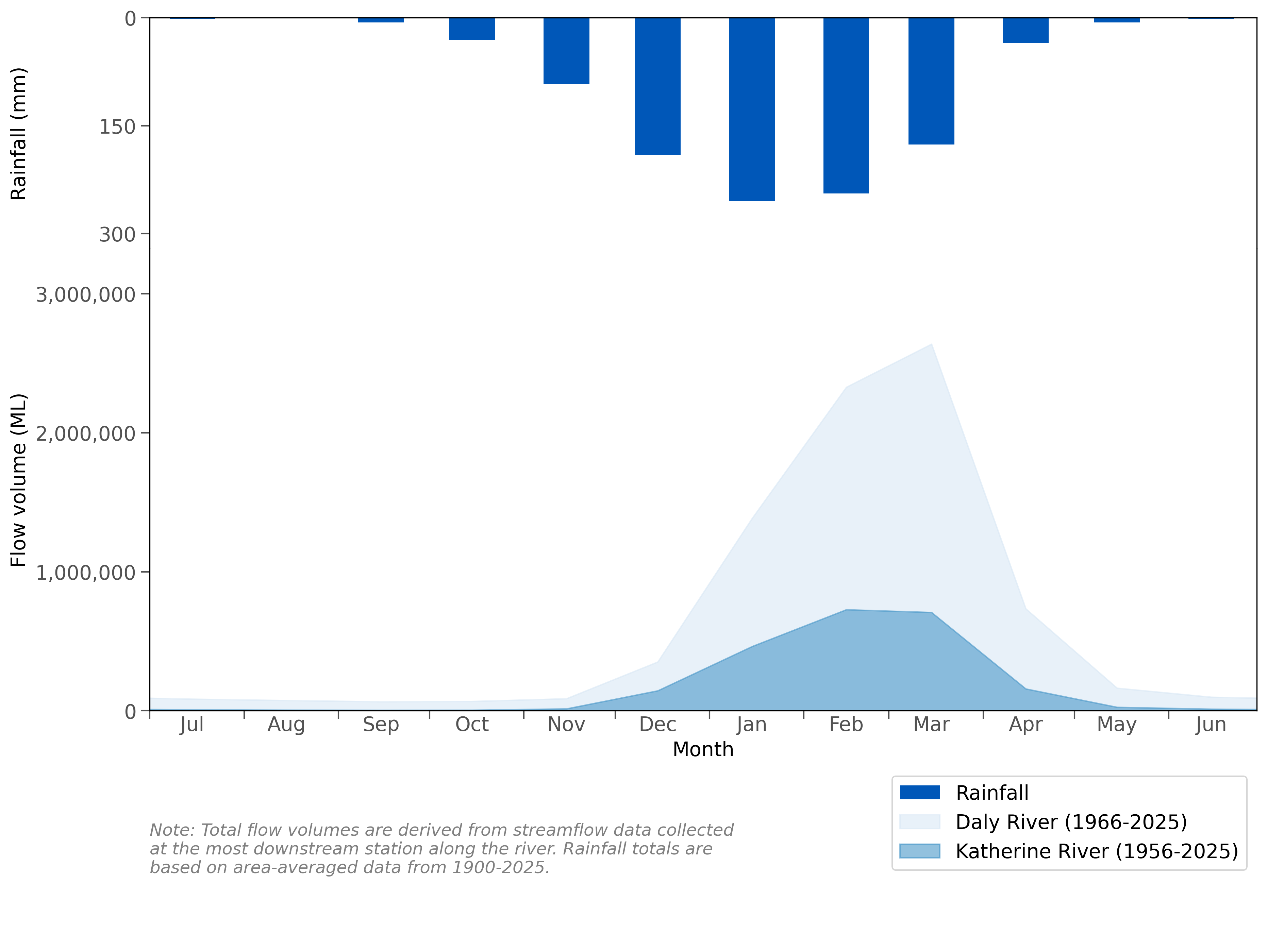
Figure R7 Mean monthly flows along the Katherine and Daly rivers and mean monthly rainfall for the Daly region
- Rainfall in the Daly region is highly seasonal, with almost all precipitation occurring between October and April during the northern wet season. As a result, most streamflow occurs in the latter half of the wet season, typically between January and May.
- Despite this variability, groundwater discharge ensures that the Daly River maintains flow throughout the dry season, making it one of the few perennial rivers in northern Australia.
- Further information on rainfall and streamflow conditions across the Daly region is provided in the Climate and water section of the account.
Storages
- Copperfield Dam is the region’s largest surface water storage and supplies the nearby town of Pine Creek.
- Two weirs are located upstream of the town of Katherine on the Katherine River: Knott’s Crossing and Donkey Camp Pool, both developed to provide water supply to Katherine.
- Compared to the extensive river and groundwater systems, surface water storages are a minor component of the Daly region’s overall water resources. Their volumes are not reported in the account due to data limitations, with surface water assets quantified only for rivers.
Water management
Surface water and groundwater management
Water legislation
- Under the Water Act 1992, the Northern Territory Government holds ownership of all water on behalf of the public (referred to as being vested in the Crown).
- The Act provides the legislative framework for managing and allocating water in the Daly region, including for agriculture, public supply, stock and domestic use, and industry, while ensuring that adequate provisions are made to maintain cultural and environmental requirements.
- Responsibility for implementing the Act rests with the Minister for Environment, supported by the Department of Lands, Planning and Environment, which proclaims water management areas and regulates the taking of water.
- Supporting instruments such as the Water Regulations 1992 set out the practical mechanisms for implementation, including licensing, permitting, and pollution control across the Northern Territory.
- Additional legislation—including the Environment Protection Act 2019 and the Waste Management and Pollution Control Act 1998—provides the regulatory basis for environmental impact assessments, waste discharge licensing, and pollution control, all of which influence the protection and management of water resources in the Daly region.
Water allocation plans
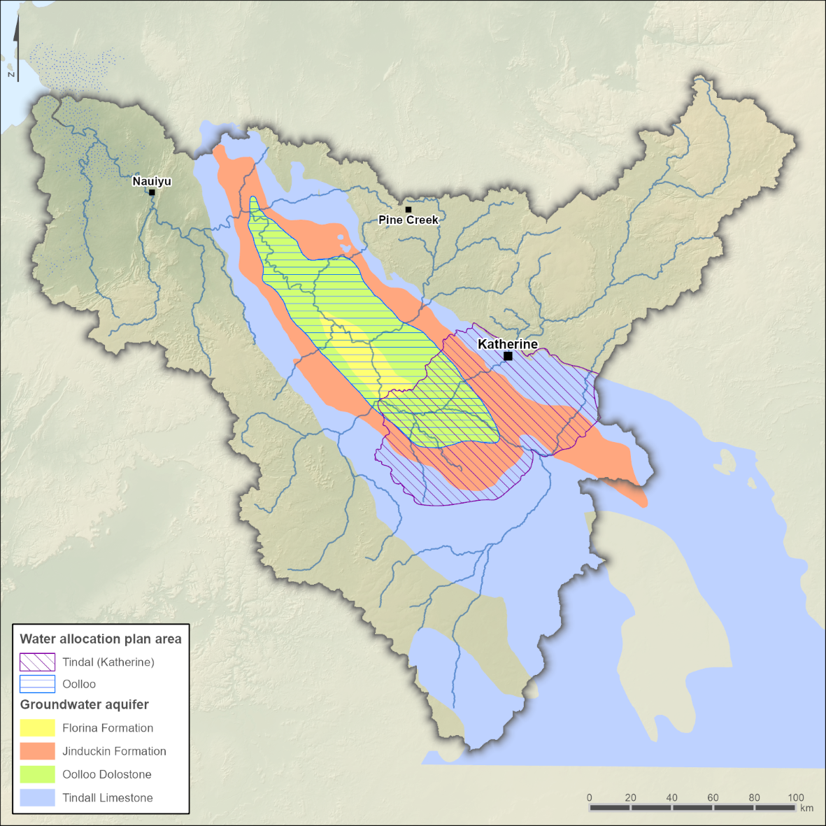
Figure R8 Water allocation plan areas in the Daly region
- The Department of Lands, Planning and Environment, through its Water Resources Division, leads the development and implementation of water allocation plans in the Daly region.
- These plans guide the licensing and sharing of water—including agriculture, public supply, stock and domestic, and industry—while protecting environmental and cultural values.
- Water-sharing decisions were historically governed by the Katherine Tindall Limestone Aquifer water allocation plan, which was recently updated for the 2024-26 period. The plan is set to expire in February 2026, after which it will be reviewed and either revised, replaced, or expanded as appropriate.
- A second plan—the Oolloo Dolostone Aquifer water allocation plan—was declared in November 2019 and governs groundwater extraction from the Oolloo Dolostone aquifer. This plan carries a ten-year term, expiring in November 2029, at which point it will also be reviewed to determine whether revision, replacement, or expansion is required.
- Both allocation plans set sustainable limits to protect environmental baseflows and include provisions for Aboriginal Water Reserves, ensuring ecological and cultural priorities are safeguarded.
- Broader reform is also underway via the Territory Water Plan, the Northern Territory's first whole-of-government strategic water policy, which aims to strengthen governance, improve climate resilience, and enhance transparency.
Water management programs
- Since becoming a signatory in 2004, the Northern Territory has adopted the principles of the National Water Initiative to enhance water productivity, ensure the sustainability of surface and groundwater, and set standards for water quality, licensing, and Indigenous water access.
- An independent review of the National Water Initiative by Badu Advisory in 2023 assessed the Northern Territory’s progress against national water reform goals and recommended greater attention to Indigenous water rights and stakeholder engagement.
- The Water Security for Northern Australia Program, delivered through a partnership between the Cooperative Research Centre for Developing Northern Australia and the Northern Australia Universities Alliance, has identified the Daly River catchment as one of four priority areas across northern Australia to address constraints on sustainable water resource use. This program will provide more information to decision-makers on water resource availability and allocation, environmental impacts and management, greater economic returns from the use of water resources, and improved Indigenous access to water resources.
- Research under the National Environmental Science Program has assessed environmental water requirements in the Daly River, identifying flow–ecology relationships and dry-season flows critical for sustaining fish, turtles, and other wildlife.
- Led by CSIRO, the Northern Australia Water Resource Assessments investigated opportunities for expanding water-dependent industries in the Daly region, while incorporating Indigenous water values and identifying safeguards for sustainable development.
- Introduced in 2023, the Territory Water Plan provides the Northern Territory’s first whole-of-government strategic water policy, outlining priorities for cultural and environmental protection, stronger governance, and improved climate resilience.
Environmental water management
- Environmental water in the Daly region is managed through the Katherine Tindall Limestone Aquifer water allocation plan and the Oolloo Dolostone Aquifer water allocation plan, both prepared under the Water Act 1992. These plans define environmental water provisions to ensure long-term sustainability of rivers and groundwater systems.
- The environmental provisions in both plans focus on maintaining aquifer discharge into the Katherine and Daly rivers, which provides the perennial baseflows that sustain riparian and riverine ecosystems through the dry season.
- Management rules are designed to preserve key flow characteristics—including dry-season baseflows, seasonal variability, and flood pulses—so that ecological functions and habitats remain intact.
- Plan provisions also recognise the interconnected nature of groundwater and surface water, ensuring that groundwater extraction limits are tied to maintaining critical environmental flows, preventing the degradation of groundwater-dependent ecosystems.
- Ongoing monitoring and modelling track aquifer discharge and river flows, with adaptive management mechanisms allowing for adjustments if environmental thresholds are at risk of being compromised.
- Both allocation plans are periodically reviewed to ensure they remain fit-for-purpose and reflect updated scientific knowledge, changing conditions, and the long-term protection of ecological and cultural values in the Daly region.
- The Northern Territory Environment Protection Authority (NT EPA), operating under legislation such as the Environment Protection Act 2019 and Waste Management and Pollution Control Act 1998, complements these provisions by regulating pollution and waste discharge to protect aquatic ecosystems.
- Through environmental impact assessments and licensing, the NT EPA ensures that development proposals and industrial activities do not compromise water quality or the ecological values supported by environmental flows.
Cultural water management
- Water management in the Daly region explicitly recognises the cultural and spiritual significance of water to Aboriginal people, with many sacred sites, ceremonial tracks, and traditional practices linked to the Daly River and its tributaries.
- Under the Water Act 1992, Aboriginal interests are formally considered in water planning, including the recognition of customary rights to maintain access to water places for cultural, social, and subsistence purposes.
- Both the Katherine Tindall Limestone Aquifer and Oolloo Dolostone Aquifer water allocation plans include provisions for Aboriginal Water Reserves, ensuring water is set aside to support future cultural and economic development by Traditional Owners.
- Traditional Owner involvement is embedded in planning processes through bodies such as the Daly River Management Advisory Committee, and through consultations that inform the design, review, and adaptation of water allocation plans.
- Projects such as the Northern Territory’s Cultural Water Needs initiative have further documented the water requirements of culturally significant sites—such as springs, waterholes, and river reaches—providing a basis for integrating cultural values into environmental and water management decisions.
- Cultural provisions are periodically reviewed alongside allocation plans, ensuring that Aboriginal rights and values remain protected as conditions, knowledge, and community priorities evolve.
Organisations responsible for water management
- The Northern Territory Government holds overarching responsibility for water resource management under the Water Act 1992, setting the framework within which agencies and utilities operate.
- Within this framework, the Department of Lands, Planning and Environment leads the planning, allocation, and regulation of water use, including licensing and compliance across declared management areas.
- Power and Water Corporation provides reticulated water supply and sewerage services to Katherine, Pine Creek, and several remote Aboriginal communities in the Daly region.
- Oversight of mining and industrial activities rests with the Department of Mining and Energy, which regulates water extraction for mining operations and issues discharge licences for industry.
- The Northern Territory Environment Protection Authority regulates water-related environmental impacts under legislation including the Environment Protection Act 2019 and the Waste Management and Pollution Control Act 1998, with responsibilities for waste discharge licensing, pollution control, and environmental impact assessments.
- Further detail on the roles and responsibilities of water management organisations in the Daly region is provided in Table R1.
| Organisation | Responsibilities |
| Northern Territory Government |
|
| Department of Lands, Planning and Environment |
|
| Northern Territory Environment Protection Authority |
|
| Power and Water Corporation |
|
| Department of Mining and Energy |
|
Water rights

Operating rules and constraints
NT-wide licensing framework
- Under the Water Act 1992 and associated Water Regulations 1992, a water licence or permit is required for activities such as extracting surface or groundwater, drilling bores, interfering with waterways, or discharging waste into water. It is an offence to proceed without appropriate authorisation.
- Some common uses are exempt from licensing—for instance, stock and domestic water, agricultural road maintenance, and low‑volume bore use (up to 5 megalitres per year), provided they align with declared beneficial uses in the area.
- Bore construction or modification requires a bore work permit in water control districts or for mining works. However, shallow bores (e.g., under 3 m depth or for building foundation investigations) may be exempt.
- Extraction licences typically span 10 years, though longer terms are possible. All licences and permits rely on compliance with specified conditions, with the Northern Territory Government enforcing a compliance and enforcement policy backed by annual planning and report card transparency.
Allocation-plan-specific constraints in the Daly region
- Within the Daly region, water can only be taken from designated water management areas under licence, as regulated by the Department of Lands, Planning and Environment.
- Under the Katherine Tindall Limestone Aquifer and Oolloo Dolostone Aquifer water allocation plans, annual extraction limits depend on catchment hydrology—allocation levels are advised annually to licence holders based on river and aquifer conditions.
- The plans include adaptive mechanisms: if groundwater discharge or river baseflows fall below set thresholds, extraction may be reduced or halted to safeguard ecosystem and cultural water needs.
- Waste discharge into water (e.g. from mining or sewage) requires a waste discharge licence administered by the Northern Territory Environment Protection Authority under the Waste Management and Pollution Control Act 1998, ensuring releases are consistent with beneficial uses of water resources.
Water entitlements and other statutory water rights
- The Department of Lands, Planning and Environment administers water extraction licences under the Water Act 1992. These licences define the annual water entitlement—the maximum volume that may be taken, the tenure (commonly up to 10 years), and the conditions of use.
- In the Daly region, entitlements are set within the Katherine Tindall Limestone Aquifer and Oolloo Dolostone Aquifer water allocation plans, which establish sustainable extraction limits and distribute entitlements across beneficial uses while reserving water for environmental and cultural needs.
- Under the Act, certain riparian rights exist as an incident of land ownership—allowing landholders adjoining a waterway to use reasonable quantities of water for domestic and stock purposes without requiring a licence.
- Water entitlements are not transferable separately from land—they can only be transferred if the associated land parcel changes ownership, reinforcing their land-bound nature as per riparian doctrine.
- Beyond riparian rights, no additional statutory water rights exist in the Northern Territory, with all other surface and groundwater use requiring a licensed entitlement.
Water allocations
- Annual allocations are determined and announced by the Department of Lands, Planning and Environment before 1 May each year, representing the volume available for licensed use after environmental provisions and domestic requirements are met.
- The Katherine Tindall Limestone Aquifer and Oolloo Dolostone Aquifer water allocation plans set the sustainable extraction limits for their respective aquifers. These limits are reviewed annually and adjusted to reflect prevailing hydrological conditions.
- Each licence specifies a maximum annual entitlement, but the amount available in any given year depends on the announced allocation, expressed as a percentage of that entitlement.
- Licence holders may access their allocation progressively across the year but must comply with monthly or seasonal extraction rules that help maintain aquifer discharge and dry-season flows.
- Allocations are non-cumulative: unused water cannot be carried over to the next water year, with all remaining allocation forfeited at year’s end.
- Adaptive management provisions in the plans allow allocations to be reduced during droughts or low-flow years, ensuring that environmental and cultural water requirements remain protected.
- Annual allocation decisions are formally notified to licence holders and published on the Northern Territory Government website, providing transparency and public accountability.
- Further breakdown of annual allocations is provided in the Water use section in 'Supporting information'.
Trades and water rights transfers
- The Water Act 1992 permits the transfer of licensed water entitlements, but only within the same declared water management area and subject to compliance with plan rules and licence conditions.
- Transfers are not permitted between different water management areas, ensuring that water remains tied to the hydrological system for which it was allocated.
- Within the Daly region, the Katherine Tindall Limestone Aquifer and Oolloo Dolostone Aquifer water allocation plans provide the rules governing trades, including requirements to demonstrate that transfers will not compromise environmental flows or cultural water values.
- All proposed trades are assessed by the Department of Lands, Planning and Environment, which evaluates potential impacts on aquifer levels, groundwater–surface water interactions, and compliance with extraction limits.
- Trades may occur as permanent transfers (linked to the licence) or temporary assignments (seasonal transfers which form part of an allocation), but both require approval through the licensing framework.
- In practice, trading activity in the Daly region has been limited, reflecting the small number of licences, their relatively modest volumes, and the strong connectivity between groundwater and surface water systems.
- Information on water trades and transfers, including plan-specific rules and application processes, is published in the relevant allocation plans and on the Northern Territory Government website.