


South East Queensland: Geographic information
- The South East Queensland region is located on the southeast coast of Queensland, and includes the major population centres of Brisbane, the Gold Coast, and the Sunshine Coast.
- Most of the region's water, collected and stored through an extensive network of water bodies consisting of creeks, rivers, wetlands, lakes. and bays, primarily feeds into the Coral Sea.
- Approximately 95% of all water sourced across the region is from surface water resources, primarily for urban supply.
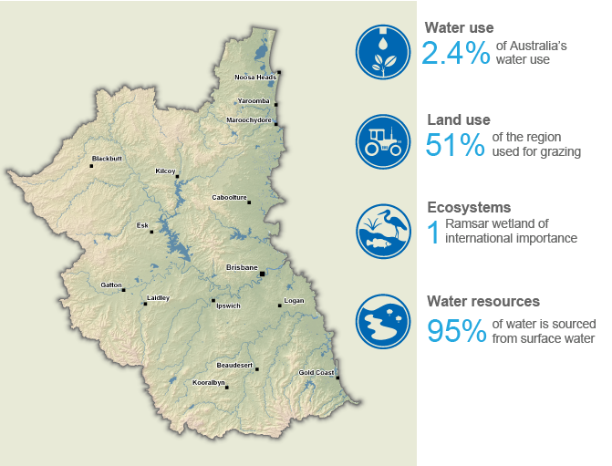
This section provides an overview of the South East Queensland region, including its population, land use, topography, culturally and environmentally significant areas, and water resources, as well as its water management arrangements and water rights provisions.
For further information, scroll down this page or click on the links below:
Geographic information
General description
Area: 24,081 km²
Population: 3.57 million (Australian Bureau of Statistics 2021 - South East Queensland*)
*South East Queensland includes Greater Brisbane Area, Sunshine Coast, and Gold Coast
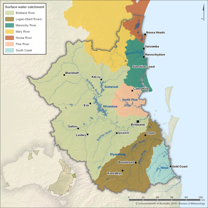
Figure R1 Contextual map of the South East Queensland region
- Situated on Queensland’s southeast coast, the South East Queensland region includes the major population centres of Brisbane, Ipswich, the Gold Coast, and the Sunshine Coast.
- The region is defined by the physical boundaries of the Brisbane, Logan–Albert, Maroochy, and Pine river catchments, along with the South Coast catchment and parts of the Mary and Noosa river catchments.
- A diverse network of creeks, rivers, wetlands, lakes, bays, and coastline contributes to the region’s extensive water system, which ultimately drains into the Coral Sea.
Land use
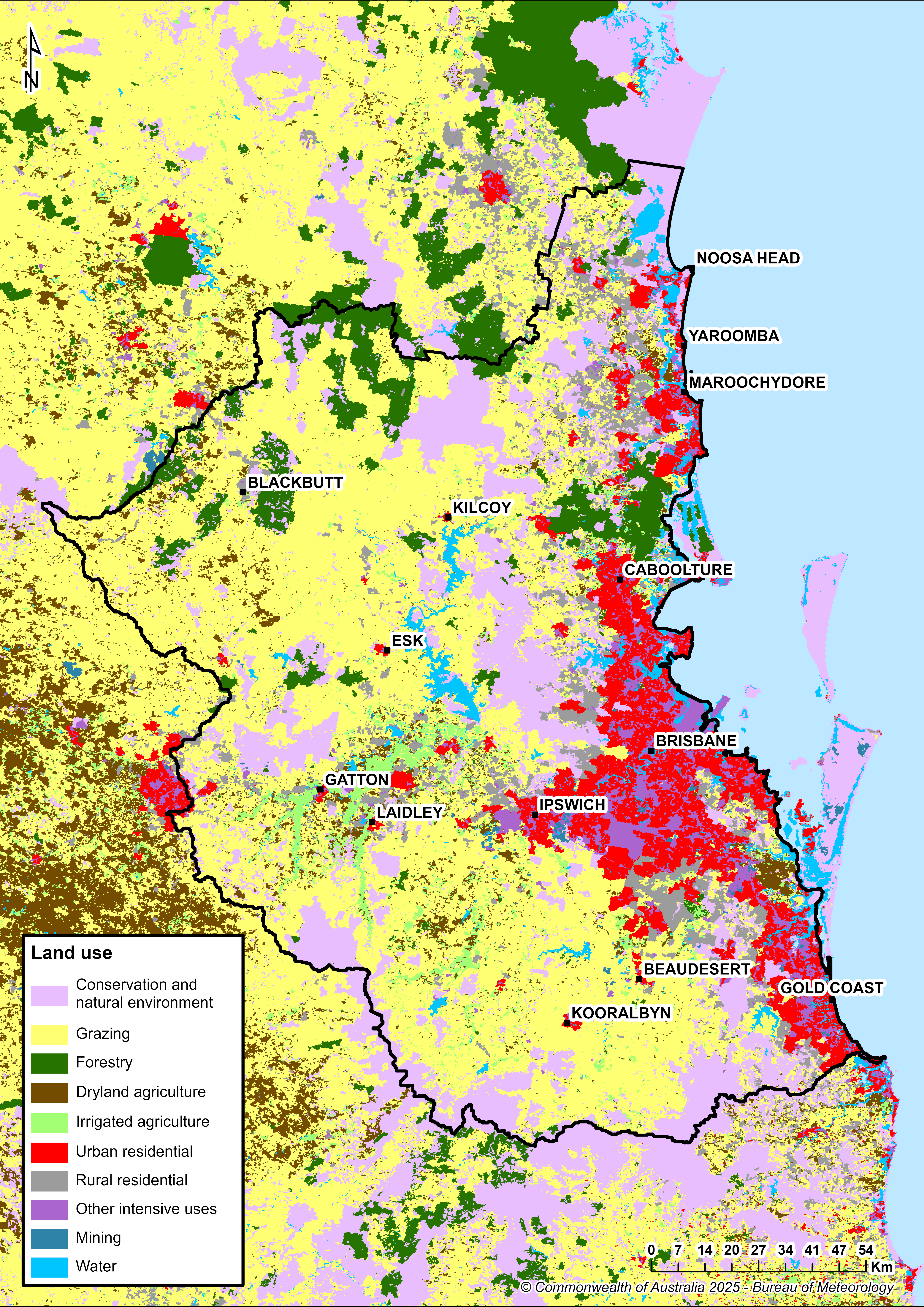
Figure R2 Land use in the South East Queensland region
- The South East Queensland region is the most densely populated area of Queensland, encompassing the major urban centres of Brisbane (2.28 million residents), the Gold Coast (607,700), the Sunshine Coast (336,400), and Ipswich (232,000), based on 2021 Census data.
- Urban land use activities, while covering a relatively small portion of the region (approximately 8%), are significant consumers of water resources.
- Grazing is the predominant land use outside urban centres, occupying more than 50% of the region's land area.
Significant aquatic ecosystems
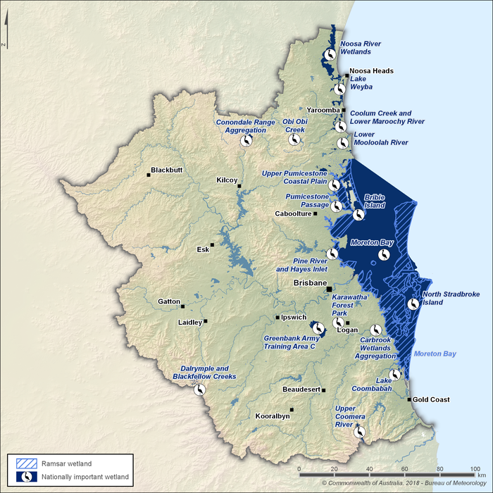
Figure R3 Nationally important wetlands and Ramsar wetlands in the South East Queensland region
- The wetlands of Moreton Bay, classified as an Australian Ramsar Wetland, are located off the southeast coast of Queensland. They extend from the southern Sunshine Coast to the northern Gold Coast and include Moreton and North Stradbroke Islands. Covering over 120,000 hectares, these wetlands feature extensive intertidal seagrass beds, mangroves, saltmarshes, freshwater lakes, bays, and coral assemblages.
- Moreton Bay is globally significant for its ecological diversity. It supports threatened fauna (such as green turtles, dugongs, humpback dolphins, and eastern curlews), meets all nine Ramsar criteria, and sustains large populations of migratory shorebirds.
- The South East Queensland region also contains 17 Nationally Important Wetlands listed in the Directory of Important Wetlands in Australia.
- Collectively, these wetlands cover more than 3,200 km², ranging from perched freshwater lakes and palustrine sedge swamps on the barrier islands to intertidal mudflats, marshes, sandflats, and mangroves along nearshore marine zones.
- Groundwater-dependent ecosystems are present throughout the region, as mapped in the Groundwater Dependent Ecosystem Atlas. These include riverine wetlands, palustrine and lacustrine systems, estuarine fringes, and subterranean or spring-fed habitats that rely on groundwater to maintain ecological function.
- Riverine and palustrine groundwater-dependent ecosystems are particularly prominent across riparian corridors and coastal lowland areas, where groundwater interaction plays a key role in sustaining wetland health and biodiversity.
Significant Aboriginal cultural places
- Prior to European settlement, the South East Queensland region was home to an estimated 2,000 Aboriginal communities distributed across the Albert, Coomera, Logan, and Nerang catchment areas.
- The region covers four Indigenous sub-regions aligned with the recognised language groups of the Goori/Murri Nation, with boundaries largely defined by the region’s river systems.
- Numerous registered Aboriginal cultural heritage sites are located along waterways, as documented in the Aboriginal Cultural Water Values report. These include scarred trees, artefact scatters, middens, and other archaeological features.
- Specific water-connected cultural places include traditional fishing weirs and camps along Norman and Ekibin Creeks, situated in the areas now known as Stones Corner and Annerley.
- Creation stories and songlines—such as Warrajum (“Bunyip”) and Walmaroo (“Sand Goanna”) of the Ugarapul people—highlight deep spiritual connections to rivers, with associated sites holding both spiritual and customary significance.
- Perched freshwater lakes, particularly Brown Lake (Bummeria) on North Stradbroke Island, are culturally significant to the Quandamooka people for both ecological and spiritual reasons.
- The Queensland Aboriginal Cultural Heritage Act 2003 recognises both physical sites and intangible elements—such as place values, stories, songlines, and gathering places—that sustain Aboriginal cultural connections to land and water.
- In 2024, the Federal Court recognised native title rights for the Kabi Kabi people over more than 365,000 hectares of land and water in the South East Queensland region, including parts of the Sunshine Coast and surrounding waterways. This determination acknowledges the Kabi Kabi people’s unbroken connection to Country and grants non-exclusive rights that coexist with those of other land users.
| Sub-region | Approximate geographic location | Peoples |
| Northern sub-region | Area from the north of the Noosa River to Pine River | Gubbi Gubbi, Kabi Kabi, Jinibara, and Dalungbara people |
| Central sub-region | Area between the Pine and Logan Rivers to the western extent of the region | Jagera (Jagera, Yuggera, Ugarapul), Jinibara, and Turrbal people |
| Southern sub-region | Area between the Logan River and the southern border of the region | Yugambeh (eight tribes), Ngarang-Wal/Kombumerri, Mulanjarlie, and Eastern Yugambeh people |
| Eastern sub-region | Moreton Bay islands, adjacent mainland, and sea country | Quandamooka (Ngugi, Noonucle, Gorenpul) people |
Water resources
- Surface water is the primary source of water in the South East Queensland region, accounting for approximately 95% of all water resources, primarily used for urban supply.
- Groundwater extractions are mostly limited to the irrigation-dominated upland valleys of the region, where several alluvial aquifers are present along river valleys—most notably the Lockyer Valley and Cooloola Sandmass aquifers.
- Other water sources used across the region include desalinated water from the Gold Coast Desalination Plant and recycled water, both of which supplement surface and groundwater resources, particularly for urban and power generation purposes.
Surface water
Storages
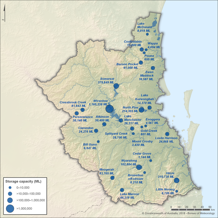
Figure R4 Surface water storages in the South East Queensland region
- Surface water storages are essential in the South East Queensland region, primarily supplying bulk water to urban centres via an interconnected network of major and minor dams.
- The five largest storages—Wivenhoe, Somerset, Hinze, North Pine, and Wyaralong—account for about 80% of the region’s total surface water storage capacity.
- Water is frequently transferred between storages through the South East Queensland Water Grid, using an extensive network of pipelines and pumping stations to manage supply during dry periods or following high rainfall events.
- Major improvement projects are currently underway through Seqwater’s Dam Improvement Program to ensure storages comply with current flood, seismic, and structural safety standards, as outlined in the Water Supply (Safety and Reliability) Act 2008.
- Under the Dam Improvement Program, current projects include upgrade works on Lake Macdonald Dam, North Pine Dam, Somerset Dam, and Wivenhoe Dam, with works expected to be completed by October 2035.
Rivers
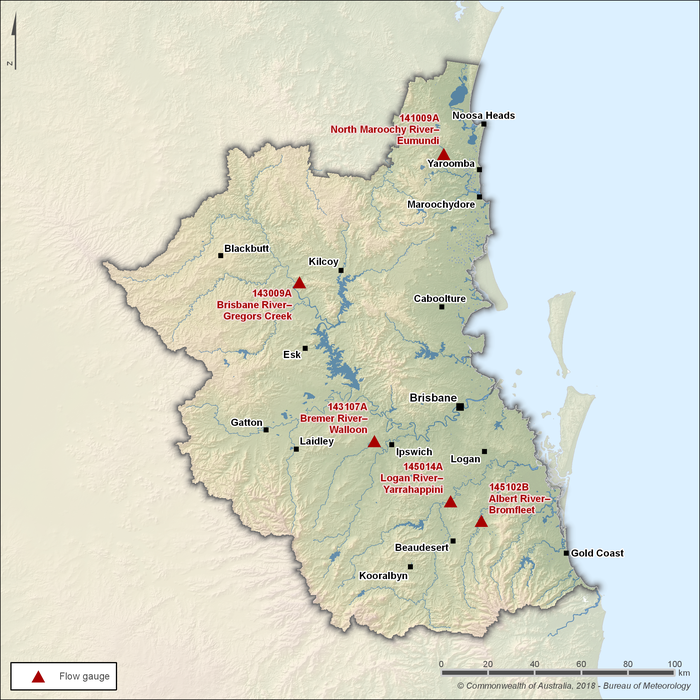
Figure R5 Key flow gauging stations along the main rivers within the South East Queensland region
- There are five main river systems within the South East Queensland region: the Albert, Bremer, Brisbane, Logan, and Maroochy rivers. Of these, the Brisbane and Logan rivers are the primary contributors to regional streamflow.
- The Brisbane River—regulated by Wivenhoe Dam—flows through the city of Brisbane and is highly susceptible to major flooding during extreme rainfall events. Significant flood events have occurred in 1974, 2011, and most recently in 2022.
- Seasonal streamflow patterns across the region are represented by five key flow gauging stations, shown in Figure R5.
- The Albert, Brisbane, Logan, and Maroochy rivers generally exhibit perennial flows, while the Bremer River may intermittently cease to flow, particularly during the drier months from May to September.
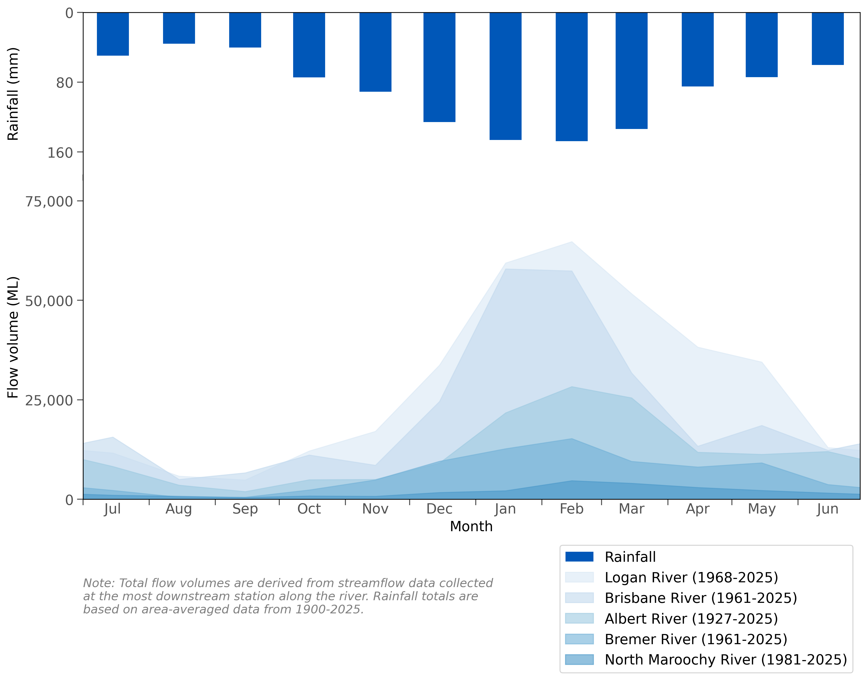
Figure R6 Mean monthly flow along the rivers and mean monthly rainfall for the South East Queensland region
- Rainfall occurs throughout the year in the South East Queensland region, though higher rainfall totals are more common during the northern wet season between October and April.
- Streamflows across the region generally reflect the distribution of rainfall during the year, with higher flows and increased storage inflows occurring during the wet season. Some rivers, such as the Bremer River, may cease to flow during the drier months from May to September.
- Further information on rainfall and streamflow conditions across the South East Queensland region is provided in the Climate and water section of the account.
Groundwater
- Groundwater extracted from alluvial aquifers is the primary water source in the irrigation-dominant upland valleys of the South East Queensland region. The Lockyer Valley alluvial aquifer, in particular, is extensively used for irrigation and is managed under the Water Plan (Moreton) 2007.
- Most of the groundwater extracted across the region comes from alluvial aquifers. However, non-alluvial aquifers, such as the Cooloola Sandmass aquifer (managed under the Water Plan (Mary Basin) 2024), also provide town water for Rainbow Beach, in addition to supporting commercial and domestic supply to surrounding areas.
- A sustainable extraction limit of 9,340 megalitres per year is set for the Lockyer Valley aquifer's benefited area (as part of the Central Lockyer Water Supply Scheme), while extractions from the Cooloola Sandmass subartesian aquifer are capped at 1,775 megalitres per year.
- Groundwater not only provides water for human needs but also plays a critical role in sustaining baseflows to waterways, particularly during dry periods. In the Lockyer Valley, creeks contribute up to an estimated 30,000 megalitres of springflow per year that supports recharge of alluvial aquifers, underpinning approximately 12,000 hectares of irrigated agriculture.
- Coastal perched and regional aquifers—such as those in the Cooloola Sandmass—support important groundwater-dependent ecosystems, including the Cooloola Patterned Fens and dune lakes. Extractions are closely monitored to ensure groundwater levels and quality do not pose ecological risks to aquatic life or groundwater-dependent ecosystems.
Desalinated water
- The Gold Coast Desalination Plant, located in Tugun, was constructed between 2006 and 2009 to bolster South East Queensland’s water supply during the Millennium Drought. Owned by Seqwater, it was the first large-scale desalination facility built on Australia’s eastern seaboard.
- When operating at full capacity, the plant can produce up to 133 megalitres per day (approximately 45 gigalitres per year) and uses reverse osmosis technology to convert seawater into potable water.
- Since December 2010, the plant has primarily operated in ‘hot standby’ mode, conducting three runs per fortnight (producing 5 megalitres per run) to maintain operational readiness. It can ramp up to 33% capacity within 24 hours and reach full capacity within 72 hours when required.
- Desalinated water from the plant supplements the South East Queensland Water Grid, particularly during drought, floods, or when other treatment facilities are offline due to planned maintenance or unexpected shutdowns. The plant plays a key role in supporting regional water security during such disruptions.
- The Queensland Government’s Water Security Program 2023 outlines a proposed expansion of the Gold Coast Desalination Plant to increase capacity by 45 megalitres per day—bringing total production to 178 megalitres per day by 2033—as part of the region’s long-term water security strategy to meet future demand.
Recycled water
- Initiated under the 2004 Pimpama–Coomera Waterfuture Master Plan, the Pimpama–Coomera Dual Reticulation Scheme was designed to reduce potable water consumption by up to 84% in the rapidly growing northern Gold Coast area. It supplies Class A+ recycled water through a dual-reticulation system to over 3,700 homes and businesses for non-drinking purposes such as toilet flushing, garden irrigation, car washing, and firefighting.
- Class A+ recycled water refers to highly treated wastewater suitable for a range of non-potable uses. It undergoes advanced treatment processes, including filtration, disinfection, and often reverse osmosis, to meet stringent water quality standards.
- The Western Corridor Recycled Water Scheme, commissioned between 2006 and 2008 at a cost of approximately $2.5 billion, is Australia's largest recycled water project. It comprises three advanced water treatment plants—located at Bundamba, Gibson Island, and Luggage Point—and over 200 kilometres of pipelines, with a capacity to produce up to 232 megalitres of purified recycled water per day.
- Initially, the Western Corridor Recycled Water Scheme was used to supply water to power stations and industrial users. Since 2015, it has remained in care and maintenance mode, activated only under specific drought conditions when dam levels fall below certain thresholds.
- Despite its significant capacity, the scheme has not been used to supplement drinking water supplies, primarily due to public perception and policy considerations.
- Recent discussions have highlighted the potential to more fully utilise existing recycled water infrastructure as part of a broader strategy to enhance long-term water security in the region.
- More information on recycled water can be found on Seqwater's Purified Recycled Water website.
Water systems
Urban water system
- Seqwater is the bulk water supply authority for the South East Queensland region. It sources, stores, treats, and supplies water via the South East Queensland Water Grid.
- Water from the grid is managed and distributed by Seqwater to local water service providers—including the City of Gold Coast, Logan City Council, Redland City Council, Queensland Urban Utilities, and Unitywater—which supply potable water to most residents within the region.
- The South East Queensland Water Grid comprises a network of infrastructure, including 12 dams, 31 conventional water treatment plants, 3 advanced water treatment plants, 1 desalination plant, 33 bulk water reservoirs, 22 pump stations, and over 600 kilometres of two-way pipelines used to transfer treated water between communities across the region.
- A pipeline between Wivenhoe Reservoir and Cressbrook Creek can be used to supply raw water to Toowoomba Regional Council, if required.
- Several 'off-grid' communities within the region—comprising approximately 53,000 people across 16 locations—are not directly connected to the South East Queensland Water Grid. Instead, these communities source and treat their drinking water locally.
- The Queensland Government has confirmed more than $300 million in funding for the Toowoomba to Warwick Pipeline project. This 111-kilometre pipeline will boost water security for the Toowoomba and Southern Downs region and will draw water from the SEQ Water Grid via the Wivenhoe Pipeline. Seqwater will construct, own, operate, and maintain the pipeline, which is expected to be completed and operational by 2027.
- A detailed map of the South East Queensland Water Grid infrastructure is available on Seqwater’s website: SEQ Water Grid Map.
Farm dams
- According to the Department of Local Government, Water and Volunteers, there are approximately 1,700 farm dams larger than 0.25 hectares in area within the South East Queensland region, with a combined estimated storage volume of 59,080 megalitres.
- These off-channel storages are primarily used for stock watering and small-scale irrigation. While they are not included as water assets in the South East Queensland's water account, they play a role in supporting agricultural activities within the region.
Water management
Surface water and groundwater management
Water legislation
- The Water Act 2000 provides the legislative framework for the sustainable management of Queensland's water resources, including the administration of water entitlements such as interim allocations, water licences, water allocations, and unallocated water. The Water Regulation 2016 supports the Water Act 2000 by detailing procedures, fees, and requirements associated with water access entitlements and trading.
- Under Section 42 of the Water Act 2000, water plans are developed to advance the sustainable management of water resources. Four water plans are currently in effect across the South East Queensland region:
- Water Plan (Gold Coast) 2006
- Water Plan (Logan Basin) 2007
- Water Plan (Mary Basin) 2024
- Water Plan (Moreton) 2007
- The Planning Act 2016 governs land use and development in Queensland. It regulates the construction of overland flow works and other water-related infrastructure through development assessment processes.
Water management plans
- The Department of Local Government, Water and Volunteers is responsible for the development, implementation, and management of water planning instruments across Queensland.
- A list of the current water management planning instruments relevant to the South East Queensland region is provided in Table R2.
- Under the Water Act 2000, water plans have an active term of ten years, after which they are reviewed and either revised, replaced, or expanded as appropriate.
- In November 2018, draft amendments to the Water Plan (Moreton) 2007 and the Moreton Water Management Protocol were published, aiming to establish water allocation and management arrangements for existing entitlement holders within the Central Lockyer Valley Water Supply Scheme.
- Currently, the Department of Local Government, Water and Volunteers is in the process of reviewing and replacing the Water Plan (Gold Coast) 2006, Water Plan (Logan Basin) 2007, and Water Plan (Moreton) 2007, which expire on 14 December 2026, to address current and emerging issues within the water plan areas.
- The Great Artesian Basin and Other Regional Aquifers (GABORA) water plan area extends into parts of the South East Queensland region. However, resources from this plan area are not included in the South East Queensland water account.
Surface water
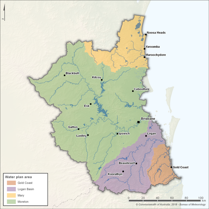
Figure R7 Water plan areas in the South East Queensland region
- Surface water resources across the South East Queensland region are managed under four current water plan areas, including the:
- Water Plan (Gold Coast) 2006 – which oversees coastal catchments in the southern part of the region, including the Tallebudgera and Currumbin creek systems. It includes Hinze Dam, the primary bulk water storage for the City of Gold Coast.
- Water Plan (Logan Basin) 2007 – which manages key catchments such as the Logan River, Albert River, and Burnett Creek, covering approximately 4,200 square kilometres. Major storages within the plan area include Maroon Dam and Wyaralong Dam.
- Water Plan (Mary Basin) 2024 – which replaced the Water Plan (Mary Basin) 2006 in May 2024 following nearly three years of community consultation and scientific assessment. It defines water availability for consumptive use and sets environmental flow requirements to support ecosystem health. Key storages include Baroon Pocket Dam and Borumba Dam.
- Water Plan (Moreton) 2007 – which covers over 15,000 square kilometres, including the catchments of the Brisbane, Pine, and Caboolture rivers, as well as Cabbage Tree and Pumicestone creeks. It encompasses several large water storages, including Somerset, Wivenhoe, and North Pine dams.
- Collectively, these water plans establish the framework for managing both supplemented and unsupplemented surface water and groundwater resources across the region. They aim to protect environmental flows, recognise basic landholder rights, and ensure water is allocated and shared sustainably among users.
- The Department of Local Government, Water and Volunteers is currently reviewing and replacing the Water Plan (Gold Coast) 2006, Water Plan (Logan Basin) 2007, and Water Plan (Moreton) 2007, which are scheduled to expire on 14 December 2026, to address current and emerging issues within each water plan area.
Groundwater
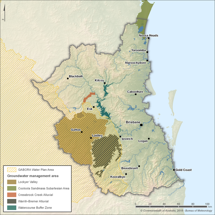
Figure R8 Groundwater management areas in the South East Queensland region
- Groundwater resources across the South East Queensland region are managed under five groundwater management areas, including the:
- Cooloola Sandmass subartesian area
- Cressbrook Creek Alluvial
- Lockyer Valley
- Warrill Bremer Alluvial
- Watercourse Buffer Zone
- Four of these areas fall within the Water Plan (Moreton) 2007, while the Cooloola Sandmass subartesian area is managed under the Water Plan (Mary Basin) 2024.
- The Water Plan (Mary Basin) 2024 includes specific provisions for the management of the Cooloola Sandmass underground water management area, supporting the sustainable use and protection of groundwater resources.
- Parts of the Great Artesian Basin and Other Regional Aquifers (GABORA) water plan area extend into the western portion of the South East Queensland region. However, water resources from the GABORA plan area are not included in the South East Queensland water account.
Water management programs
- A number of water management programs are implemented across the region to support the sustainable use, protection, and integration of water resources. Key examples include:
- Seqwater's Dam Improvement Program – the largest capital investment program to date by Seqwater, focusing on upgrading several dams to meet modern engineering standards and ensure long-term water security. Current projects include:
- Lake Macdonald Dam – works commenced in 2025 to enhance flood resilience and storage capacity.
- North Pine Dam – staged strengthening works are planned to commence in 2025.
- Somerset Dam – early works and geotechnical investigations are underway to inform future upgrades.
- Wivenhoe Dam – an options analysis is being conducted to determine the necessary improvements.
- Toowoomba to Warwick Pipeline Project – a $300 million initiative by Seqwater to construct a 111-kilometre pipeline connecting Wivenhoe Dam to Warwick via Toowoomba. This project aims to enhance water security for the Southern Downs region and is expected to be operational by 2027.
- Gold Coast Desalination Plant Expansion – part of the Queensland Government’s Water Security Program 2023, this project outlines a proposed expansion of the plant to increase capacity by 45 megalitres per day—bringing total production to 178 megalitres per day by 2033—as part of the region’s long-term water security strategy.
- Western Corridor Recycled Water Scheme – a $2.5 billion project, managed by Seqwater and the largest recycled water scheme in Australia, forms an integral part of the South East Queensland Water Grid. Currently in care and maintenance mode, the scheme is being considered for recommissioning to supply purified recycled water during droughts.
- Proposed Wyaralong Water Treatment Plant – Seqwater is currently in the planning and procurement phase for a new water treatment plant at Wyaralong, aimed at augmenting the South East Queensland Water Grid and supporting future population growth.
- South East Queensland Agriculture Regional Water Assessment – initiated in January 2024, this assessment aims to improve water security for the agricultural sector by evaluating current usage, exploring alternative sources, and identifying future infrastructure needs.
Environmental water management
- Environmental water in South East Queensland is managed primarily through water plans prepared under the Water Act 2000. These plans set out environmental flow objectives and ecological outcomes to support and protect the health of water-dependent ecosystems.
- Each water plan must align with the environmental values identified in the Environmental Protection (Water and Wetland Biodiversity) Policy 2019, ensuring water management decisions maintain ecosystem health, water quality, and habitat integrity.
- The Department of Local Government, Water and Volunteers is responsible for developing, implementing, and reviewing water plans, including monitoring ecological outcomes and consulting with stakeholders to ensure environmental water objectives are met.
- Environmental flow objectives aim to maintain key flow characteristics—such as baseflows, high-flow pulses, and seasonal variability—at specified locations across river systems. These objectives are implemented through water management rules governing abstraction limits, flow sharing, and dam releases.
- The Water Act 2000 and associated water plans are reviewed periodically to ensure they remain fit-for-purpose and continue to meet their objectives. Amendments may be made as needed to reflect updated scientific knowledge, changing conditions, or emerging environmental needs.
- More information on the environmental flow objectives can be found in the four water plans relevant to the region: Water Plan (Gold Coast) 2006, Water Plan (Logan Basin) 2007, Water Plan (Mary Basin) 2024, and Water Plan (Moreton) 2007.
Cultural water management
- The four water plans active across the South East Queensland region acknowledge the cultural significance of water to Traditional Owners, and include general outcomes that support their cultural use of surface water and groundwater resources.
- Decision-makers must consider the potential impacts of various actions on cultural values, such as granting water entitlements or managing water infrastructure, and, where appropriate, impose conditions to ensure these values are maintained.
- Several broader strategies and programs influence cultural water management across the region, including:
- South East Queensland Traditional Owner Cultural Resource Management Plan (CRM Plan) – developed collaboratively with Traditional Owner groups across the region, including the Gubbi Gubbi, Yugambeh, Jagera, and Quandamooka peoples. The CRM Plan outlines cultural resource management issues and actions important to Aboriginal communities, emphasising the inseparable connection between Country, spirit, culture, and wellbeing.
- South East Queensland Natural Resource Management Plan 2009–2031 – integrates cultural values into regional planning by recognising Traditional Owners as natural resource managers. It also acknowledges the CRM Plan and its targets as integral to natural resource management across the region.
- Queensland Government’s Water Strategy – emphasises collaboration with First Nations peoples to embed cultural values in water planning. Key initiatives include engaging with Traditional Owners on Country to inform water management decisions, as well as establishing advisory groups to support ongoing participation in water programs.
- During the development of the South East Queensland Natural Resource Management Plan 2009–2031, the South East Queensland Traditional Owners Alliance played a key role in advancing the collective voice of Traditional Owner cultural groups in the region, advocating for their interests in cultural and natural resource management before ceasing operations in 2015.
- While the South East Queensland Traditional Owners Alliance is no longer active as a formal peak body, its legacy continues through the CRM Plan, which remains a foundational strategy guiding engagement with Traditional Owners and the integration of cultural values into land and water planning across the region.
- Recent developments, such as the recognition of the Kabi Kabi people's native title rights over parts of the Sunshine Coast, reflect ongoing efforts to incorporate Traditional Owner rights and values into regional land and water management.
Organisations responsible for water management
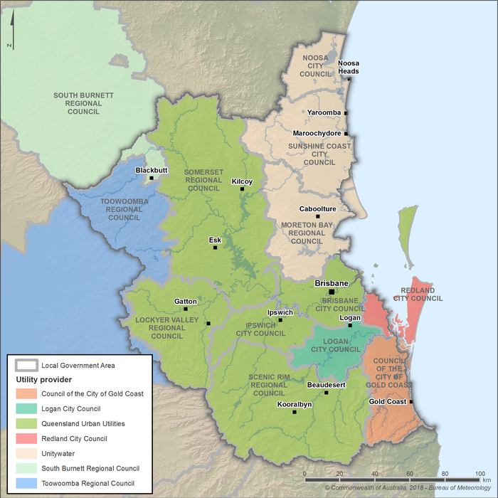
Figure R9 Utility service areas in the South East Queensland region
- Seqwater is the bulk water supplier for the South East Queensland region, responsible for managing the region's major dams, weirs, water treatment plants, and bulk water transport infrastructure. It supplies both treated and untreated water to the South East Queensland Water Grid, as well as to local service providers across the region.
- Treated water is distributed to end users through five main service providers: Queensland Urban Utilities, Unitywater, Logan City Council, Redland City Council, and the Council of the City of Gold Coast. These entities manage local distribution networks, retail customer services, and wastewater collection and treatment. Their areas of operation are illustrated in Figure R9.
- Water planning, regulation, and policy development is led by the Department of Local Government, Water and Volunteers, which oversees the implementation and review of water plans under the Water Act 2000.
- The Queensland Water Directorate (qldwater) does not manage water directly but coordinates centralised data and provides technical support for almost all water management entities across Queensland.
- Further detail on the roles and responsibilities of water management organisations in the South East Queensland region is provided in Table R3.
| Organisation | Responsibilities |
| Queensland Government |
|
| Department of Local Government, Water and Volunteers |
|
| Department of the Environment, Tourism, Science and Innovation |
|
| Queensland Water Directorate (qldwater) |
|
| Healthy Land and Water |
|
| Seqwater |
|
| Stanwell Corporation |
|
| Queensland Urban Utilities |
|
| Unitywater |
|
| Council of the City of Gold Coast |
|
| Logan City Council |
|
| Redland City Council |
|
| Toowoomba Regional Council |
|
| South Burnett Regional Council |
|
Water rights
Operating rules and constraints
- Water abstraction in the South East Queensland region is regulated by the Department of Local Government, Water and Volunteers through water planning instruments and water authorisations.
- According to the water plans, water can only be taken or interfered with from designated areas when authorised through a water allocation, licence, or permit.
- Resource operations licences and distribution operations licences govern the operation of water supply scheme infrastructure and the distribution of water to allocation holders. These licences include rules for day-to-day operations, water sharing, and seasonal water assignments, and must be adhered to by licence holders.
- Surface water licences are also issues for unsupplemented water (water not supplied through infrastructure such as dams or weirs). These licences authorise activities such as taking water, interfering with water flow, or constructing diversions.
- Groundwater resources in parts of the South East Queensland region are managed under groundwater management areas defined in water plans. These include:
- The Lockyer Valley, Warrill Bremer Alluvial Area, Watercourse Buffer Zone, and Cressbrook Alluvial Area under the Water Plan (Moreton) 2007.
- The Cooloola Sandmass under the Water Plan (Mary Basin) 2024.
- Water restrictions are coordinated by Seqwater, the SEQ distributor-retailers (council water businesses), and the Department of Local Government, Water and Volunteers.
- Regional water restrictions are triggered when the combined storage level of South East Queensland's major dams falls to 50%.
- Localised water restrictions may also be applied to off-grid communities that are not connected to the South East Queensland Water Grid, based on local supply conditions.
- Further details on current and historical water restrictions is available on the Queensland Government water restrictions website.
Water entitlements and other statutory water rights
- Under the Water Act 2000, water may be taken under a statutory authorisation (without an entitlement) for limited purposes—such as stock and domestic use—or under formal water entitlements including water allocations, licences, or permits.
- Supplemented and unsupplemented water entitlements are managed separately in South East Queensland. Supplemented water is delivered through water supply schemes operated under resource operations licences, while unsupplemented water is generally accessed directly from rivers, lakes, or groundwater.
- Groundwater entitlements issued in artesian and sub-artesian systems are subject to local management arrangements in designated groundwater areas such as the Lockyer Valley, Warrill Bremer Alluvial area, and Cressbrook Alluvial area.
- Water allocations are statutory instruments with defined volumetric limits, reliability characteristics, and trading rights. In South East Queensland, these are typically associated with regulated surface water and supplemented groundwater systems.
- Seasonal water assignments (temporary trades) and permanent transfers of water allocations are permitted within or between water supply schemes, subject to approval by the Department of Local Government, Water and Volunteers.
- Access to water is also guided by water sharing rules and prioritisation frameworks established under the Mary Basin and Moreton water plans, which specify how entitlements are distributed during different flow conditions.
Water allocations
- Supplemented water allocations are issued annually for users within designated water supply schemes in South East Queensland. These allocations are managed under resource operations licences and distribution operations licences.
- The water year generally runs from 1 July to 30 June, unless specified otherwise in the relevant water plan or operations manual.
- Allocation announcements for supplemented entitlements are announced at the beginning of the water year by the resource operations licence or distribution operations licence holder (e.g. Seqwater).
- Additional announcements may be made during the year based on water availability.
- Announcements cannot be reduced below the initial announced percentage, nor can they exceed 100% of the allocation volume.
- Entitlements are prioritised within each scheme. Urban and essential services typically hold high priority allocations, which are more reliably supplied and are often announced at 100%.
- Other users may hold medium or low priority allocations, which are more sensitive to storage levels and inflows.
- Unsupplemented water entitlements—taken directly from rivers or groundwater—are managed separately. Water access is governed by flow conditions and announced periods that allow abstraction only when specific thresholds are met.
- These thresholds are set to maintain environmental flow requirements, as outlined in the Mary Basin and Moreton water plans.
Trades and water rights transfers
- Water trading in Queensland occurs through three main mechanisms:
- The water allocation market, which involves the permanent transfer of regulated water access entitlements.
- The seasonal water assignment market, which facilitates the temporary (annual) transfer of water allocations or available water volumes.
- The relocatable water licence market, which allows the movement of a water licence from one parcel of land to another within defined geographic boundaries.
- In South East Queensland, most water trading involves surface water entitlements within designated water supply schemes. Groundwater trading is not currently active in the region, though it may be considered under future planning arrangements.
- Water allocations in Queensland are statutory rights separate from land title, and may be partly or wholly traded subject to relevant conditions. All trades are recorded in the Queensland Water Allocation Register maintained by Business Queensland.
- Relocatable licences may also be traded after assessment, but must remain within their defined plan area or management zone to ensure consistency with regional water planning objectives.
- The rules for water trading and seasonal water assignments are defined in the Water Regulation 2016, the region’s four water plans (Gold Coast, Logan Basin, Mary Basin, and Moreton), and supporting operations manuals.
- Trade rules specify geographic and hydrological constraints to ensure that trades do not compromise environmental flow objectives or reduce the reliability of existing water entitlements.
- Intra-scheme trading within a water supply scheme (e.g. between two users in the Central Lockyer or Logan River Water Supply Scheme) is more common than inter-scheme or inter-basin trading.
- Trading volumes and trends are published annually through the Queensland Water Markets Report, which helps inform future policy and market development.