Forecast weather
Data layers
MetEye displays different layers from the Australian Digital Forecast Database (ADFD). The ADFD is a database of official weather forecast elements produced by the Bureau of Meteorology, such as temperature, rainfall and significant weather types, presented in a gridded format. The Bureau of Meteorology uses the ADFD to produce text forecasts and warnings; and in map displays.
MetEye also displays
- Forecast locations: which give a textual forecast for 7 days for selected locations.
- Other gridded data such as computer generated Numerical Weather Prediction (NWP) models - The Mean Sea Level Pressure data is sourced from the Australian Community Climate Earth-System Simulator (ACCESS).
- Tropical Cyclone forecast tracks which are generated by the Tropical Cyclone warning centres in each region.
Further detail is in the Descriptions of data layers section.
Coverage of the layers
- The Mean Sea Level Pressure data is covers the broader region, based on the coverage of the Australian Community Climate Earth-System Simulator (ACCESS) model.
- Forecast data is available for selected states/territories, over the land areas and some way out to sea (nominally to an extent of 60 nautical miles).
Issue and Update times
The ADFD files are updated routinely four times per day at around 05:00, 11:00, 17:00 and 23:00 UTC (Coordinated Universal Time). The ADFD may be updated at other times on an event driven basis.
The ADFD data uses the Coordinated Universal Time (UTC) time zone.
The time assigned to a grid represents the commencement time as follows:
- for all data showing 3-hourly time steps, the forecast is for the start of the hour shown. Note however, that for the Significant Weather data, the map represents the presence of that weather type over the whole 3-hourly time step, starting at the hour shown.
- for data issued for a 24 hour period the following rules apply:
- for rainfall the period is the 24 hours from 15 UTC
- for daily maximum temperature the period is from 1900 to 1300 UTC to represent daylight hours across the country
- for daily minimum temperature the period is from 0700 to 0100 UTC to represent night time hours across the country
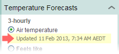
Note: If you want to check when the layer was last updated then this information is displayed, in the left-hand menu, below each item.
Forecast icons
MetEye uses the same icons that appear across all of the Bureau's weather forecasts. A description of each icon is provided here.
Auto refresh
MetEye will automatically refresh itself every 30 minutes for forecast data.