


Melbourne: Geographic information
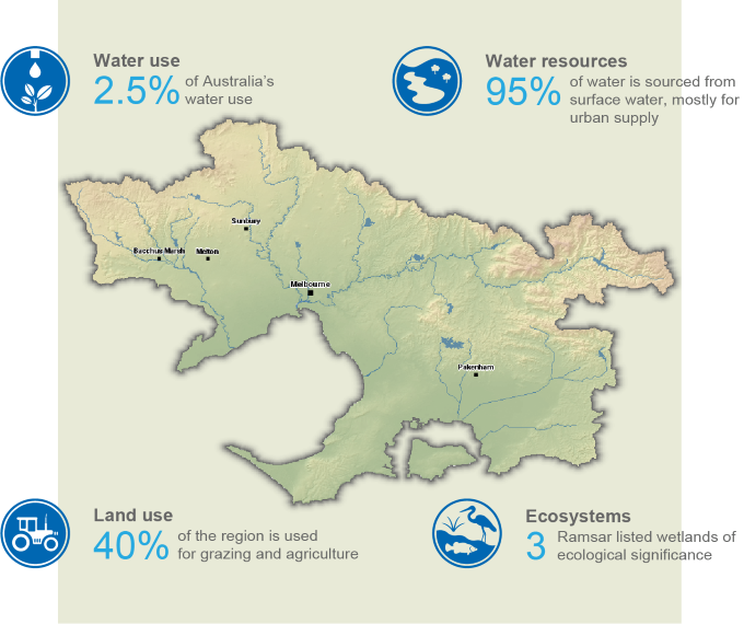
- The Melbourne region, located in south-eastern mainland Australia, is home to approximately 75% of Victoria’s population, as of the 2021 Census.
- Surface water is the region’s primary water source, supporting both urban water supply and irrigation schemes across the region.
- Desalinated water is also available for urban use, providing a climate-independent alternative resource that supplements the region’s storages.
This section provides an overview of the Melbourne region, including its population, land use, topography, culturally and environmentally significant areas, and water resources, as well as its water management arrangements and water rights provisions.
For further information, scroll down this page or click on the links below:
Geographic information
General description
Area: 11,723 km²
Population: 4.92 million (Australian Bureau of Statistics [ABS] 2021 - Greater Melbourne Area)
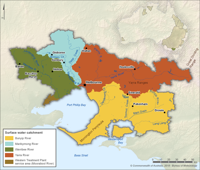
Figure R1 Contextual map of the Melbourne region
- Located in the southeast of mainland Australia, the Melbourne region contains over 75% of Victoria's population, as of the 2021 Census.
- The region is defined by the hydrological boundaries of the Bunyip, Maribyrnong, Werribee and Yarra river catchments, along with an additional 105 km² area serviced by the Melbourne Water Western Treatment Plant beyond the Werribee River catchment area.
- Approximately 2.5% of Australia's water use occurs in the region, primarily from surface water resources for urban supply.
Land use
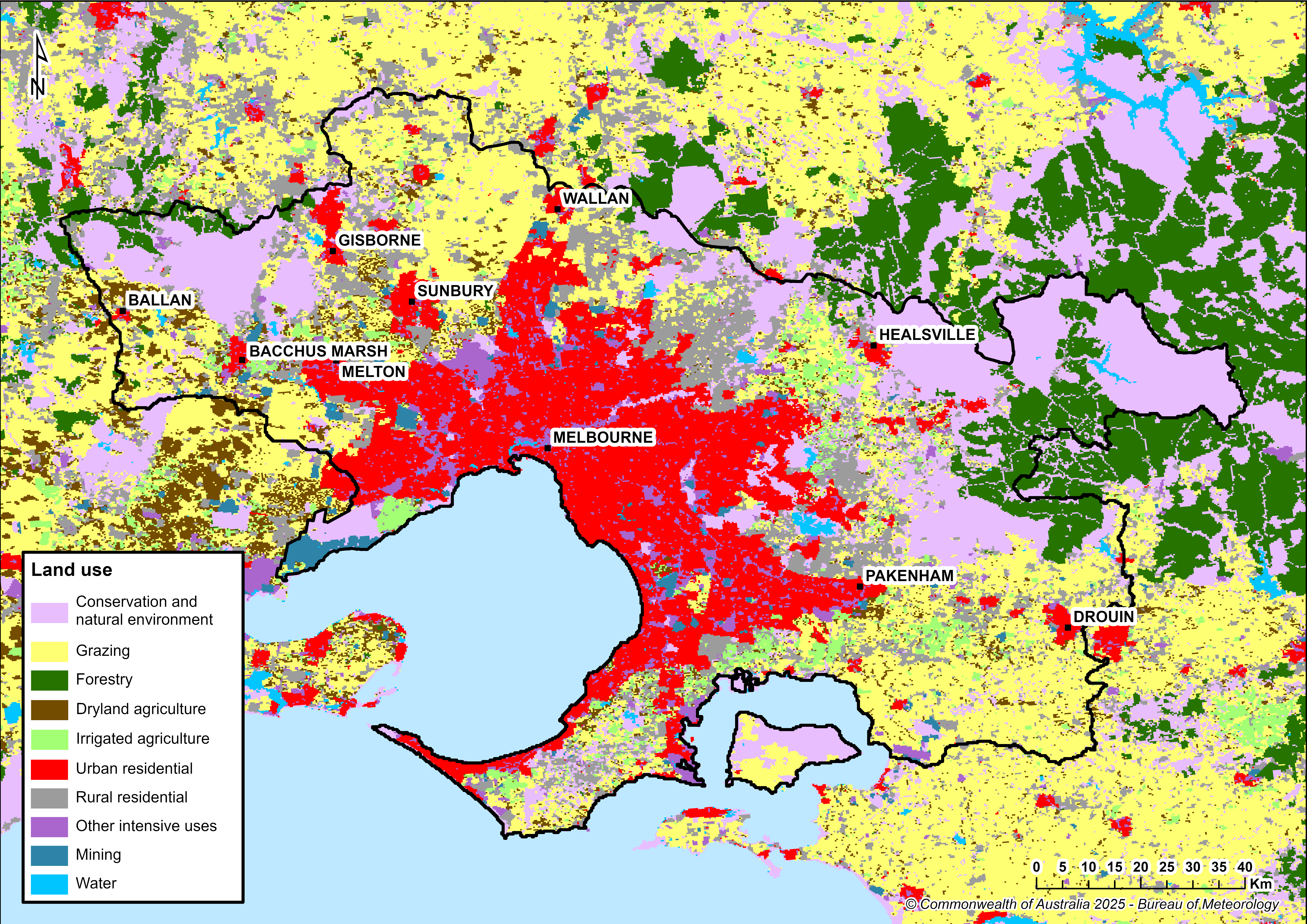
Figure R2 Land use in the Melbourne region
- Urban centres account for approximately 23% of the region’s total area, with most residents living in the Melbourne metropolitan area.
- About 34 % of the region is used for grazing, making it the predominant land use activity outside urban areas.
- The Werribee and Bacchus Marsh irrigation districts, located within the Werribee catchment, support important vegetable‑growing regions supplying Melbourne (see Irrigation schemes).
Significant aquatic ecosystems
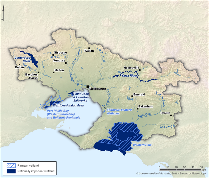
Figure R3 Nationally important and Ramsar-listed wetlands in the Melbourne region
- The Melbourne region contains three Ramsar-listed wetlands of international importance:
- Edithvale–Seaford Wetlands – encompassing approximately 261 hectares (Edithvale: 103 ha, Seaford: 158 ha), these wetlands are the largest natural wetland of their type in the Port Phillip–Westernport basins. They are the remnants of the ancient Carrum Carrum Swamp, a large inter-dunal lagoon largely drained in the late 19th century.
- Port Phillip Bay (Western Shoreline) & Bellarine Peninsula – comprising six distinct areas, including the Western Treatment Plant and Avalon wetlands, these wetlands cover approximately 22,900 hectares. They are the sixth most important area in Australia for migratory waders, and the most important in Victoria, providing vital habitat for shorebird protection and forming part of the broader Important Bird and Biodiversity Areas.
- Western Port Bay – covering approximately 60,000 hectares of tidal flats, saltmarshes, mangroves, seagrass beds, and islands, this area is recognised for its biodiversity and as a critical feeding and roosting area for migratory birds. Western Port Bay is among the three most important areas for waders in Victoria and supports numerous migratory species listed under international conservation agreements. It also provides habitat for the globally threatened fairy tern, listed as vulnerable on the IUCN Red List of Threatened Species.
- In addition to the Ramsar-listed sites, the region contains five nationally important wetlands listed in the Directory of Important Wetlands in Australia: the Lerderderg River wetlands, Point Cook and Laverton Saltworks, Werribee–Avalon wetlands, Yarra River wetland complex, and Mud Islands (within Port Phillip Bay).
- These wetlands support a rich array of habitats—including freshwater and saltwater marshes, tidal flats, fringing vegetation, and seagrass beds—which are essential for waterbirds (such as the Australasian bittern, curlew sandpiper, and sharp-tailed sandpiper), migratory shorebirds, and native flora and fauna.
- Management of Ramsar-listed and nationally important wetlands is overseen by Melbourne Water in partnership with government agencies, councils, and community groups. This includes the recently completed Two Great Ramsar Wetlands project (2018–2023), as well as the ongoing Ramsar Protection Program, which delivers coordinated pest and weed control, habitat restoration, and community engagement across Port Phillip and Western Port Ramsar sites.
- Many wetlands and riparian systems in the region rely on groundwater inflows to sustain ecological values during dry periods. Groundwater extractions are regulated via licensing to protect these ecosystems, with the Groundwater Dependent Ecosystem Atlas providing mapping guidance to support planning decisions.
Significant Aboriginal cultural places
- Aboriginal peoples of the Kulin Nation—including the Wurundjeri-willam, Boonwurrung (Bunurong), Wadawurrung, Taungurung, and Dja Dja Wurrung—have lived in the Port Phillip and Western Port region for over 30,000 years. They hold a strong cultural, spiritual, and practical connection to waterways, relying on rivers and estuaries for food, ceremony, and storytelling.
- Birrarung / Yarra River, Mordialloc Creek, Kororoit Creek, and the Port Phillip Bay foreshore contain significant cultural places, including scarred trees, fish traps, campsites, and shell middens. These sites are documented and protected under the Victorian Aboriginal Heritage Act 2006.
- Many creation stories and Dreaming narratives across the region specifically reference waterways—such as the formation of Port Phillip Bay and the Birrarung—highlighting their sacred importance to Traditional Owners.
- Cultural mapping identifies thousands of Aboriginal heritage places concentrated around rivers and creeks, reflecting long-standing relationships with water and land used for ceremony, resource gathering, and community connection.
- Melbourne Water and the Port Phillip & Westernport Catchment Management Authority actively engage with Registered Aboriginal Parties through initiatives such as Waterways of the West, which seek to embed Traditional Owner knowledge, co-management, and cultural values into waterway planning and stewardship.
- The Victorian Government’s Aboriginal Water Program works with Traditional Owner groups to restore cultural connections to waterways, supporting access for ceremony, cultural practices, and Country-based economic opportunities.
- In metropolitan Melbourne, places such as Birrarung Wilam (River Camp) at Federation Square serve as living cultural spaces where Wurundjeri Elders offer Welcome to Country, share stories of the river, and host gatherings—affirming the ongoing presence and voice of First Peoples in urban life.
Water resources
- Surface water is the primary source of water in the Melbourne region, accounting for approximately 95% of all water resources, mostly used for urban water supply.
- Groundwater resources are relatively limited and mainly extracted to support agricultural activities, particularly in areas not serviced by surface water delivery systems.
- Alternative, climate-independent water sources—including desalinated water from the Victorian Desalination Plant and recycled water from wastewater treatment facilities—are increasingly important for supplementing surface water, enhancing supply security, and supporting non-potable uses such as irrigation, industrial processing, and urban greening.
Surface water
Storages
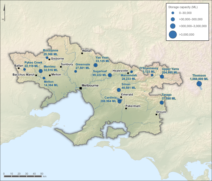
Figure R4 Surface water storages in the Melbourne region; capacity of each storage is also shown
- Surface water storages are a fundamental water source for both urban supply and irrigation schemes in the Melbourne region.
- Although the Thomson Reservoir is located outside the Melbourne region, it is the largest storage supplying water to the region, accounting for approximately 55% of the region’s total surface water storage capacity. Water is transferred from the Thomson Reservoir to the Upper Yarra Reservoir via the 35-kilometre Thomson–Yarra pipeline for distribution to the urban water supply system (see Figure R9).
- There is extensive interconnection among the region’s storages: water can be moved from Thomson to Upper Yarra, Upper Yarra to Silvan, O’Shannassy to Silvan, Maroondah to Sugarloaf, Silvan to Greenvale and Cardinia, and Cardinia to Silvan.
- The Tarago Reservoir is not connected to other reservoirs. Instead, water is treated at the Tarago Treatment Plant and directly supplied to the Mornington Peninsula.
- Water from the Victorian Desalination Plant enters the system via the Cardinia Reservoir, where it is mixed with water transferred from the Silvan Reservoir.
- Combined, Melbourne Water operates ten major reservoirs with a total capacity of approximately 1,810 gigalitres. Most of these storages supply urban and peri-urban Melbourne.
- Additional storages within the region—such as Merrimu and Pykes Creek—support irrigation and are managed by Southern Rural Water.
- For more information on the storages within the Melbourne region, see the Bureau of Meteorology’s Water Information Dashboard.
Rivers
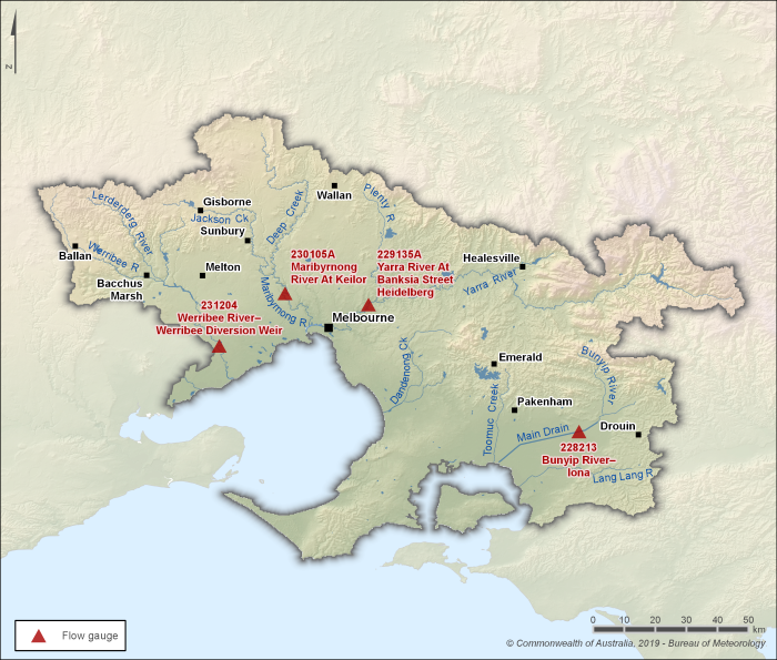
Figure R5 Key flow gauging stations along the Bunyip, Yarra, Maribyrnong, and Werribee rivers within the Melbourne region
- There are four main river systems within the Melbourne region: the Bunyip River catchment, Maribyrnong River catchment, Werribee River catchment, and Yarra River catchment.
- Streamflows in the Maribyrnong, Werribee, and Yarra rivers are influenced by diversions for consumptive use, as well as by dam operations and spills. Streamflows in the Bunyip River are less influenced by these factors.
- Four gauging stations (shown in Figure R5) are used to represent seasonal flow patterns in the region’s rivers.
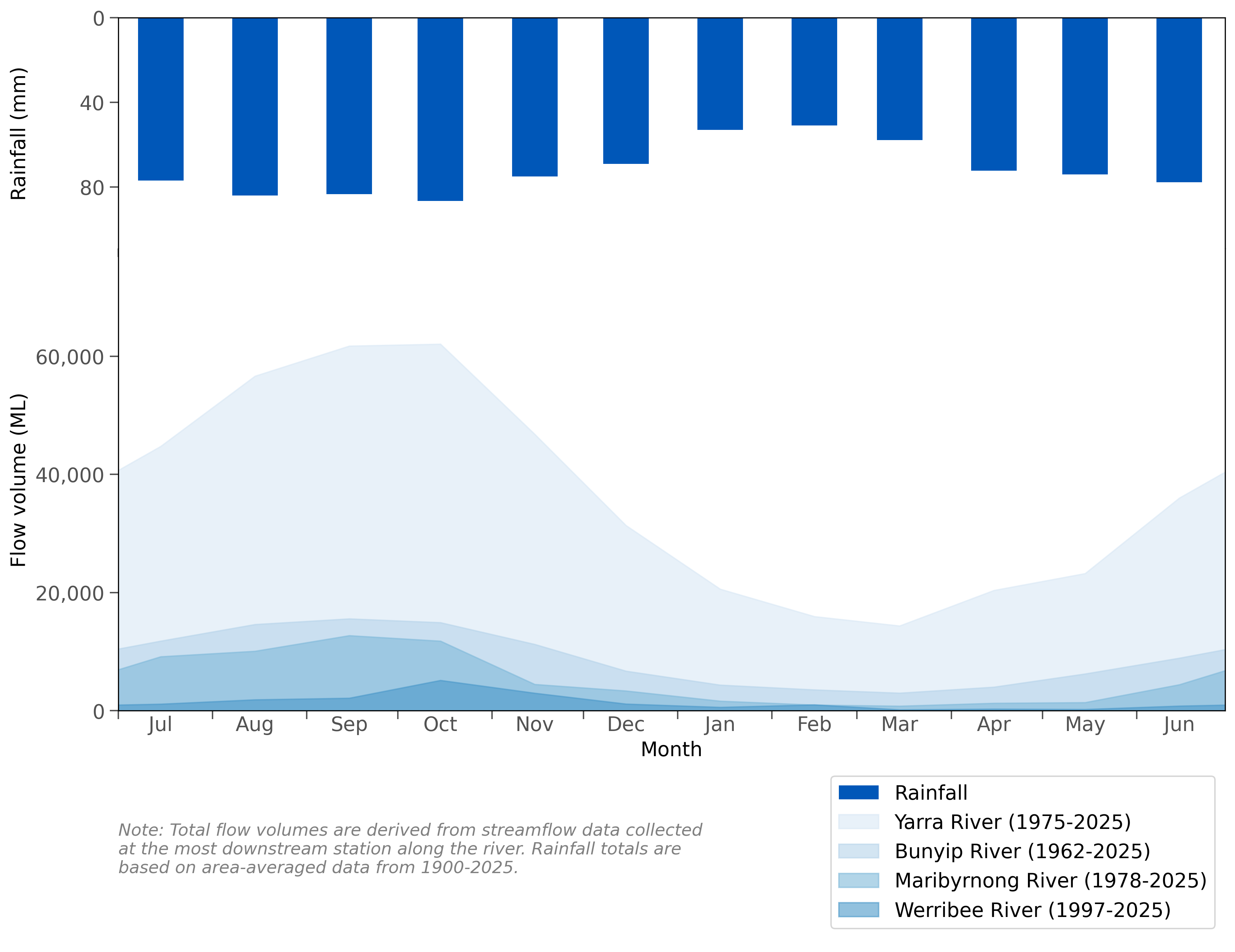
Figure R6 Mean monthly flows along the Werribee, Maribyrnong, Yarra, and Bunyip rivers, and mean monthly rainfall for the Melbourne region
- Rainfall across the Melbourne region is relatively consistent throughout the year, with higher totals more common between June and November.
- Streamflows in the region’s rivers generally reflect the seasonal rainfall pattern, with peak flows and storage inflows occurring between June and August, while lower flows are more prominent from January through April.
- Further information on rainfall and streamflow conditions across the Melbourne region is provided in the Climate and water section of the account.
Groundwater
Geological features
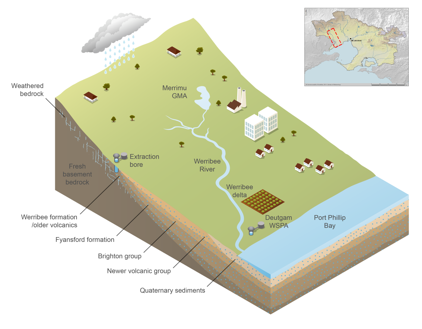
Figure R7 Groundwater system within the northern and southern zones of the western part of the Melbourne region
- The region’s geology underlying groundwater systems comprises two broad zones:
- Northern zone: Predominantly ancient (Silurian–Devonian) fractured bedrock—sandstone, siltstone, shale, and granite—overlayed in places by older and newer volcanic basalts. These fractured basalts form moderate-yield aquifers, especially where deeply weathered and fractured near the surface.
- Southern coastal zone: Dominated by unconsolidated Tertiary–Quaternary sediments, especially the Brighton Group (Red Bluff Sands and Black Rock Sandstone), Werribee Formation, as well as coastal dune and alluvial sands. These sediments host unconfined to semi-confined aquifers of variable thickness, transmissivity, and salinity.
- Groundwater is accessed from a range of aquifer units across the region, each with distinct physical properties and levels of use, including:
- Brighton Group sediments (Late Miocene–Pliocene): Laterally extensive sandy units (approximately 40 m thick), forming unconfined to semi-confined aquifers which yields moderate- to high-salinity water.
- Older and Newer Volcanics: Silicic volcanic basalts (40–150 m thick) hosting fractured rock aquifers with variable yields; unconfined near outcrops and semi-confined in buried areas.
- Fyansford Formation: Widespread marine silt, marl, and clay—largely acting as an aquitard, though coarse basal lenses can yield low volumes of moderate-salinity water.
- Deltaic and alluvial deposits: Younger sediments near river deltas (e.g. Yarra, Werribee) forming local unconfined aquifers with variable quality, influenced by depositional setting.
- Overall hydrogeology is characterised by layered aquifer–aquitard systems within the Tertiary Port Phillip Basin, overlying older bedrock aquifers. Aquifer properties (porosity, transmissivity, salinity) vary widely depending on geology, depth, and human impacts.
Groundwater management areas
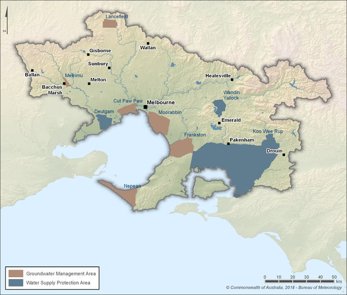
Figure R8 Groundwater management areas within the Melbourne region
- Groundwater accounts for less than 5% of the total water supplied across the Melbourne region.
- It is primarily used to supplement surface water for high-value agricultural production, including vegetables, fruits, wine grapes, flowers, and turf.
- The region contains six Groundwater Management Areas (GMAs) and three Water Supply Protection Areas (WSPAs), as shown in Figure R8, which are defined to manage extraction and ensure the sustainable use of groundwater resources:
- Groundwater Management Areas are areas where groundwater has been, or has the potential to be, intensively developed.
- Water Supply Protection Areas are areas declared under the Water Act 1989 that contain water resources requiring protection and stricter management of use.
- Each GMA and WSPA has a designated permissible consumptive volume—the maximum allowable extraction limit set to protect long-term aquifer health.
- Groundwater extraction also occurs outside these defined areas in unincorporated zones, which are managed under broader licensing and metering frameworks.
Inter-region transfers
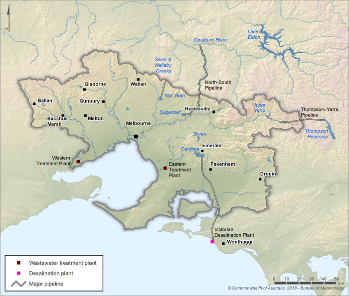
Figure R9 Melbourne's inter-regional water sources; wastewater treatment and desalination plant locations
- The Melbourne region’s urban water supply is supplemented by surface water transfers from catchments located outside the region (see Figure R9).
- Melbourne’s water authorities hold bulk entitlements to access water from two key inter-regional sources:
- Lake Eildon, as part of the Goulburn and Murray systems.
- Silver and Wallaby creeks, located in the Goulburn River catchment northeast of the region.
- Up to 66,000 megalitres of water may be diverted from Silver and Wallaby creeks into Melbourne’s storage system over a rolling three-year period.
- From the Goulburn and Murray systems, up to 75,000 megalitres per year (long-term average target) may be diverted, but only under limited circumstances—such as during periods of critical human need or to support local fire-fighting efforts.
- Water from these sources is delivered into the region via major pipelines, including the North–South Pipeline, and contributes to securing Melbourne’s water supply during dry periods.
- Gippsland Water holds bulk water entitlements totalling 8.155 gigalitres from the Tarago Reservoir and Tarago River system, which lies within the Melbourne region. This includes:
- A pre-existing 4.825-gigalitre entitlement from the Tarago River, and
- A new 3.33-gigalitre entitlement from Tarago Reservoir, acquired during the 2023–24 water year.
- These inter-regional transfers reflect the interconnected nature of Victoria’s water grid, enabling coordinated management of resources across multiple regions and supply systems.
Desalinated water
- The Victorian Desalination Plant at Wonthaggi, commissioned in December 2012, is Australia’s largest seawater reverse osmosis facility. It has a baseline capacity of 150 gigalitres per year, with the ability to be upgraded to 200 gigalitres per year.
- Melbourne’s three retail water authorities hold bulk entitlements allowing them to access an average of 150 gigalitres per five-year period, sourced from the desalination plant.
- An 84-kilometre bi-directional pipeline connects the desalination plant to Melbourne's water supply network, allowing water to flow both into and out of the system—enabling it to top up storages or supply regional towns when necessary.
- Operated by the AquaSure consortium under a 30-year Public–Private Partnership, the facility is powered by renewable energy certificates and features on-site energy efficiency measures, including a living green roof and energy recovery systems.
- Although generally kept on standby, orders for desalinated water are activated during dry conditions by the Victorian Government. In April 2025, the Minister for Water announced a desalinated water order of 50 gigalitres for the 2025–26 water year—the first since early 2022—to bolster Melbourne and regional storages in response to declining reservoir levels.
- Since the first desalinated water entered the system in March 2017, the plant has produced over 455 gigalitres of drinking water for Melbourne, Geelong, Gippsland, and Western Port communities.
- Desalinated water now forms an essential climate-independent supply, capable of contributing up to a third of Melbourne’s annual water demand, thereby enhancing system reliability during droughts.
- For further information on the Victorian Desalination Plant, refer to the Aquasure website.
Recycled water
- Two major treatment plants—the Western Treatment Plant and Eastern Treatment Plant—operated by Melbourne Water, produce high-quality Class A recycled water for non-potable uses across the Melbourne region.
- The Western Treatment Plant treats over half of Melbourne's sewage via lagoon systems with advanced disinfection, whereas the Eastern Treatment Plant treats nearly 40% using tertiary processes including ozone, biological filtration, UV, and chlorine.
- Treated wastewater is primarily used for horticulture and pasture irrigation, land and salinity management, irrigation of sports and recreation grounds, and industrial applications (for example, cooling towers and dust suppression).
- Recycled water from the Western Treatment Plant is supplied via the Werribee Irrigation District, benefiting around 90 local farms producing approximately 70% of Australia's lettuce. The Eastern Treatment Plant supports the Eastern Irrigation Scheme, serving around 80 customers in the Cranbourne district, along with residential dual-pipe systems.
- Both treatment plants capture biogas from anaerobic lagoons and digesters to generate electricity, meeting up to 100% of their onsite energy requirements. The Western Treatment Plant also produces biosolids, with approximately 36,700 tonnes applied to farmland in 2023.
- Approximately one-third of the Western Treatment Plant's Class A recycled water (around 40 gigalitres per year) is transferred to Lake Borrie Wetlands, part of the Port Phillip Bay (Western Shoreline) and Bellarine Peninsula Ramsar-listed site, contributing to wetland health and biodiversity.
- Recycled water provides a climate-independent source, reducing demand on drinking water supplies and supporting sustainable urban and agricultural practices, particularly during dry periods.
- For more information on recycled water production in the Melbourne region, see Melbourne Water’s Producing recycled water website.
Stormwater
- Several stormwater harvesting schemes operate across the Melbourne region, though the volume captured remains small compared to recycled water. Notable examples include:
- Melbourne Park – Harvests runoff from stadiums and paved areas, storing around 52 megalitres annually in a 4.5 megalitre underground tank. This supplies approximately 68% of the precinct’s non-potable demand, with plans to exceed 80% through future expansion.
- Royal Park – One of the region’s earliest and most successful schemes. It diverts flows from a 187-hectare catchment into a constructed wetland and 17 megalitre storage complex. A sediment-trapping diversion structure allows only low flows into the wetland. Treated water flows to the storage, with overflow directed to Moonee Ponds Creek. This system supplies up to 80% of Royal Park’s irrigation needs.
- City of Melbourne – Multiple wetlands and rain gardens harvest stormwater to irrigate parks and street trees in locations such as Fitzroy Gardens, Queen Victoria Gardens, and Birrarung Marr.
- Greater Western Water Stormwater Harvesting Partnership – A regional collaboration that has delivered eight co-funded projects—such as the Melbourne Ballpark scheme—focusing on reducing potable water use by supplying alternative sources for open space irrigation.
- The Australian Guidelines for Water Recycling (Phase 2) – Stormwater Harvesting and Reuse provide a national reference to support the sustainable reuse of stormwater, greywater, and treated wastewater. Melbourne Water uses these guidelines to develop technical standards and licensing processes for harvesting on public assets, including design of diversion structures, quality controls, and environmental protections.
- Although stormwater contributes a relatively minor volume compared with recycled and potable sources, it provides multiple benefits: reducing demand on drinking water, improving urban water quality, enhancing green spaces, and supporting Melbourne’s transition to water-sensitive urban design.
- For more information on stormwater harvesting schemes and design standards, see Melbourne Water’s Stormwater harvesting website.
Water systems
Urban water system
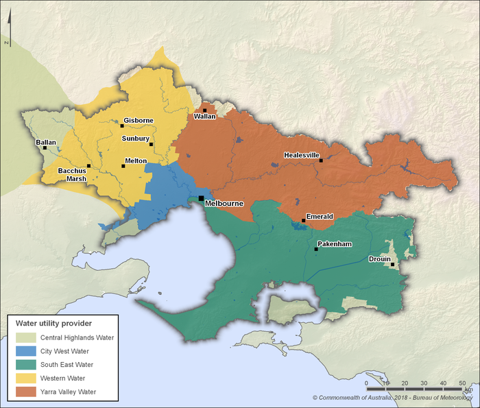
Figure R10 Urban retail and regional water authority service areas within the Melbourne region
- Urban water supply in the Melbourne region is sourced primarily from surface water, captured and stored in catchments managed by Melbourne Water. The utility operates most of the surface water storages and supply infrastructure throughout the region, delivering bulk water to retail and regional water authorities for distribution to customers.
- Three urban retail water authorities operate within the Melbourne region: Greater Western Water, South East Water, and Yarra Valley Water. Each sources its bulk water supply exclusively from Melbourne Water and is responsible for distributing drinking water, managing wastewater services, and overseeing elements of stormwater infrastructure within its service area, as illustrated in Figure R10.
- Greater Western Water was formed on 1 July 2021 through the merger of City West Water and Western Water. Its service area spans inner Melbourne, the rapidly growing outer western suburbs, and several peri-urban communities.
- Central Highlands Water services a small portion of the outer western Melbourne region, although its primary area of operation lies beyond the metropolitan boundary. It manages a combination of local surface water catchments, groundwater sources, and bulk water supplied by Melbourne Water.
Irrigation schemes
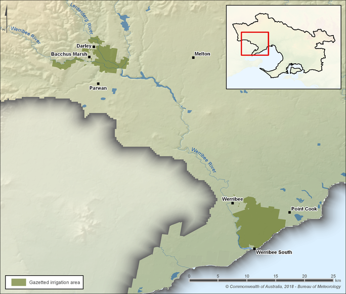
Figure R11 The Werribee and Bacchus Marsh irrigation districts within the Melbourne region
- Southern Rural Water operates two major irrigation districts within the Melbourne region—Werribee and Bacchus Marsh—as shown in Figure R11. These areas are among Victoria’s most productive horticultural zones.
- The Werribee Irrigation District covers approximately 3,000 hectares and supports over 100 irrigated farms. It is especially known for producing lettuce, broccoli, cauliflower, and other leafy greens, contributing significantly to both Victoria’s and Australia’s fresh produce supply.
- The Bacchus Marsh Irrigation District spans approximately 1,000 hectares and is characterised by smaller-scale intensive horticulture, including fruit orchards, nurseries, and vegetable crops.
- Both irrigation districts are supplied by regulated surface water sources, primarily Pykes Creek Reservoir, Merrimu Reservoir, and Melton Reservoir. Water allocations vary based on inflows and seasonal conditions.
- In addition to surface water, recycled water from Melbourne Water’s Western Treatment Plant supplements supply, particularly during dry periods. Around 5 billion litres (5 gigalitres) of recycled water is piped annually to the Werribee Irrigation District, enhancing reliability and supporting year-round productivity.
- Modernisation works across both districts, led by Southern Rural Water, have included pipeline upgrades and system automation to reduce water losses and improve delivery efficiency to irrigators.
Water management
Surface water and groundwater management
Water legislation
- Key legislation governing water management in the Melbourne region includes the Water Act 1989 and the Water Industry Act 1994. These Acts form the basis for water allocation, governance, and service delivery across Victoria.
- The Water Act establishes the legal framework for the allocation, use, and management of the state’s surface water and groundwater resources. It defines water entitlements, the role of water corporations, and mechanisms for environmental water management.
- Under the Water Act, the Victorian Government retains the right to the use, flow, and control of all water in the state. It also regulates bore construction, groundwater extraction, and licensing of private and commercial water use.
- The Water Industry Act sets out the licensing, governance, and performance obligations of Government-owned urban and regional water authorities, including Melbourne Water and the metropolitan retail water corporations.
- These Acts are complemented by the Environment Protection Act 2017 and associated policies, which regulate water discharge standards, protect waterway health, and promote integrated water management outcomes.
Water management plans
- Victoria’s water entitlement and allocation framework takes a whole-of-system approach, managing both surface water and groundwater across all phases of the water cycle. It supports consumptive and environmental use, enabling long-term planning through integrated policy instruments.
- Bulk entitlements are a core component of the framework, granting water authorities the legal right to take and use water from rivers, reservoirs, and other sources. Melbourne Water holds multiple bulk entitlements across key sources, including the Maribyrnong, Silver & Wallaby Creeks, Tarago & Bunyip Rivers, Thomson River, and Yarra River. These entitlements are publicly accessible via the Victorian Water Register Bulk Entitlements website.
- Streamflow management plans are used to manage water extractions from unregulated rivers while maintaining essential environmental flows. Melbourne Water administers streamflow management plans for Water Supply Protection Areas in the Melbourne region, balancing the needs of licensed diverters and river ecosystems. These plans include rules for water sharing, rostering during low flows, and ongoing monitoring and compliance. More information is available on Melbourne Water’s Streamflow management website.
- Groundwater management plans are developed for declared Water Supply Protection Areas where there is high demand or a risk of resource depletion. These statutory plans set extraction limits and licensing rules to protect long-term groundwater availability. An overview of groundwater management is available on the Managing Groundwater page of the Victorian Government’s Water and Catchments website.
Water management programs
- A range of state-wide and region-specific programs support water management across the Melbourne region, guiding planning, infrastructure delivery, and integrated water cycle outcomes. The following initiatives provide a broad overview of the strategic frameworks currently influencing water management in the region, though they do not represent an exhaustive list.
- Strategic water planning frameworks:
- The long-term direction for managing water resources across south-central Victoria, including the Melbourne region, is outlined in the Central and Gippsland Region Sustainable Water Strategy (2022). This strategy sets a 50-year vision focused on securing water for agriculture, ecosystems, communities, industry, and Traditional Owners, with a strong emphasis on climate adaptation, demand efficiency, stormwater and recycled water use, and integrated catchment management.
- A coordinated approach to urban water planning in metropolitan Melbourne is delivered through the Greater Melbourne Urban Water and System Strategy: Water for Life, a 50-year strategy jointly developed by Greater Western Water, Melbourne Water, South East Water, and Yarra Valley Water. It builds on individual Urban Water Strategies to identify long-term demand pathways, augment supply options, and improve resilience to drought and climate change.
- The Melbourne Water System Strategy, released in 2017, provides a detailed regional perspective on how Melbourne Water manages its bulk water supply operations over the long term. It aligns with statewide policies, such as Water for Victoria, and integrates catchment management, waterway health, environmental flows, and collaborative system planning with retail water utilities.
- Retail water authorities prepare Urban Water Strategies every five years under policy guidance from the Department of Energy, Environment and Climate Action, setting out local demand forecasts, water efficiency actions, drought preparedness, and infrastructure investment plans. These strategies now inform and align with the broader Water for Life strategy.
- Integrated and collaborative management initiatives:
- Collaborative water planning across government agencies, utilities, and local government is supported by the Integrated Water Management (IWM) Framework for Victoria, which establishes a formal model for partnership-based project delivery and promotes liveability, resilience, and environmental outcomes through shared water management.
- Catchment-wide coordination is delivered through the Catchment Management Framework, which underpins regional Catchment Strategies developed by Victoria’s Catchment Management Authorities. In the Melbourne region, this function is delivered by Melbourne Water for the Port Phillip and Westernport catchment, under the Catchment and Land Protection Act 1994.
- Statewide policy for river, wetland, and estuary health is established through the Victorian Waterway Management Strategy, which guides regional waterway strategies and supports catchment-scale environmental outcomes delivered by Melbourne Water in the Melbourne region.
- Place-based and grant-supported programs:
- Community-led and council-partnered water projects are supported under the Liveable Communities, Liveable Waterways Program, a Melbourne Water grants initiative that funds activities such as stormwater harvesting, habitat restoration, and waterway activation to deliver environmental and social benefits.
- The Stream Frontage Management Program encourages private landholders and local community groups to participate in the restoration and maintenance of streambanks on public and private land, improving riparian health, erosion control, and flood resilience.
- At the municipal level, local governments prepare tailored strategies such as the Municipal Integrated Water Management Plan by the City of Melbourne, which sets specific goals for alternative water use, water quality improvement, and flood mitigation to guide infrastructure investments.
- In addition to these strategic frameworks, Melbourne Water delivers a wide range of operational programs and capital works projects that support stormwater reuse, waterway health, flood resilience, and community education across the region. For more information, visit Melbourne Water's Projects website.
Environmental water management
- The Victorian Environmental Water Holder is an independent statutory body responsible for managing Victoria’s environmental water entitlements to improve the health of rivers, wetlands, and floodplains. It makes decisions on when, where, and how much water is delivered to support environmental outcomes based on seasonal priorities and available allocations.
- In the Melbourne region, there are three formal environmental water entitlements:
- Consolidated Yarra Environmental Entitlement 2006 (revised 2014)
- Tarago and Bunyip Rivers Environmental Entitlement 2009 (revised 2014)
- Werribee River Environmental Entitlement 2011
- These entitlements define the volume, source, and release rules for environmental flows in the region's key river systems.
- Victoria’s Environmental Water Reserve represents the environment’s legal share of the water resource. It consists of:
- entitlements held for environmental use
- water set aside through licence conditions on consumptive users
- unallocated flows (above cap water) left in the system after diversion limits are met
- Melbourne Water acts as the waterway manager and environmental water delivery partner in the region, operating infrastructure and coordinating releases in collaboration with the Victorian Environmental Water Holder to ensure water reaches high-value ecological assets.
- Streamflow Management Plans support environmental water management in unregulated catchments. Within the Melbourne region, Streamflow Management Plans are in place for Hoddles Creek, Little Yarra and Don Rivers, Olinda Creek, Plenty River, Steels, Pauls, and Dixon Creeks, Stringybark Creek, and Woori Yallock Creek. These plans balance the needs of diverters with the maintenance of baseflows and seasonal environmental conditions.
- In areas with lower demand, Local Management Rules provide simpler guidance for managing surface water access and low-flow conditions. These rules support environmental outcomes while maintaining access reliability for users.
Cultural water management
- Aboriginal communities have longstanding spiritual, cultural, and economic connections to water, with rivers, wetlands, and waterways playing an integral role in cultural identity, practice, and knowledge systems. In the Melbourne region, these values are particularly significant to the Wurundjeri, Wadawurrung (Wathaurung), and Bunurong peoples.
- The Victorian Aboriginal Heritage Act 2006 recognises Aboriginal people as the Traditional Owners of the land and establishes a framework for protecting Aboriginal cultural heritage, including culturally significant water places.
- Under the Victorian Traditional Owner Settlement Act 2010, eligible Traditional Owner groups may enter into natural resource agreements that recognise rights to take and use water from a waterway or bore for traditional, non-commercial purposes. These rights are further supported by the Water Act 1989, which enables such take without the need for a licence.
- Cultural flows—defined by Aboriginal communities as water entitlements that are legally owned and managed to improve the spiritual, cultural, environmental, social, and economic conditions of Traditional Owners—are being explored and integrated through ongoing consultation and planning.
- The Water for Victoria policy outlines actions to support Aboriginal values in water management, including greater involvement of Traditional Owners in planning processes and decision-making. These actions include the appointment of Aboriginal Water Officers, development of Country Plans, and identification of priority cultural sites and values.
- In the Melbourne region, Melbourne Water partners with Traditional Owner groups to better incorporate cultural values into river and waterway management, including site assessments, protection of cultural flows, and co-design of waterway projects.
Organisations responsible for water management
- Melbourne Water is the bulk water supplier and waterway manager for the Melbourne region. It manages the region’s major reservoirs, treatment plants, and bulk transfer infrastructure, supplying treated and untreated water to the metropolitan distribution network and overseeing floodplain management, stormwater systems, and waterway health.
- Three urban retail water authorities operate within the Melbourne region: Greater Western Water, South East Water, and Yarra Valley Water. Each sources its bulk water supply exclusively from Melbourne Water and is responsible for distributing drinking water, managing wastewater services, and overseeing elements of stormwater infrastructure within its service area, as illustrated in Figure 10.
- Greater Western Water was formed on 1 July 2021 through the merger of City West Water and Western Water. Its service area spans inner Melbourne, the rapidly growing outer western suburbs, and several peri-urban communities.
- Central Highlands Water services a small portion of the outer western Melbourne region, although its primary area of operation lies beyond the metropolitan boundary. It manages a combination of local surface water catchments, groundwater sources, and bulk water supplied by Melbourne Water.
- The Department of Energy, Environment and Climate Action provides strategic oversight, policy development, and regulatory functions for water resource management. It administers the Water Act 1989 and leads the implementation of frameworks such as Water for Victoria.
- Regulatory oversight of pricing and service standards for Victoria’s urban water corporations is provided by the Essential Services Commission, ensuring efficiency, transparency, and customer protections.
- Further detail on the roles and responsibilities of water management organisations in the Melbourne region is provided in Table R1.
| Organisation | Responsibilities |
| Department of Energy, Environment and Climate Action |
|
| Essential Services Commission |
|
| Victorial Environmental Water Holder |
|
| Melbourne Water |
|
| Yarra Valley Water |
|
| South East Water |
|
| Greater Western Water |
|
| Port Phillip & Westernport Catchment Management Authority |
|
| Southern Rural Water |
|
| Central Highlands Water |
|
| Gippsland Water |
|
Water rights
Operating rules and constraints
Bulk entitlement conditions
- A bulk entitlement is a legal right granted under the Water Act 1989 that allows water corporations, the Victorian Environmental Water Holder, or other specified bodies to take and use water from a defined source, such as a river, reservoir, or groundwater system.
- Each entitlement is tailored to its holder and source, and includes operating rules that reflect water availability, environmental needs, and system constraints.
- Common conditions include maximum volumes allowed per year or per day, rules around timing and rates of extraction, minimum passing flow or release requirements to protect downstream ecosystems, and monitoring and reporting obligations.
- Additional requirements may apply in times of restriction or drought, such as sharing arrangements between entitlement holders, or compliance with seasonal determination frameworks.
- All approved bulk entitlements are publicly listed on the Victorian Water Register, which provides detailed copies of each entitlement and any amendments.
Urban water restrictions
- In times of water shortage, Melbourne’s urban water corporations may implement staged water restrictions ranging from Stage 1 (moderate) to Stage 4 (critical).
- These restrictions limit non-essential water uses such as garden watering, car washing, and pool filling, and are implemented in accordance with each utility’s Drought Preparedness Plan.
- Each plan must be approved by the Victorian Minister for Water and outlines triggers, response actions, and communication strategies for managing temporary restrictions and long-term drought resilience.
- Current Drought Preparedness Plans are available for:
- Detailed descriptions of each restriction stage are published by the Department of Energy, Environment and Climate Action and can be accessed directly:
- Stage 1 Water Restrictions
- Stage 2 Water Restrictions
- Stage 3 Water Restrictions
- Stage 4 Water Restrictions
- Permanent Water Saving Rules also apply year-round across the Melbourne region.
- These rules promote responsible water use, such as watering gardens during set times and using trigger nozzles on hoses.
- For further information, refer to:
- DECCA's Water Restrictions and Rules page.
- Melbourne Water’s Water Saving Rules page.
Water licence restrictions
- Melbourne Water and Southern Rural Water are responsible for managing surface water and groundwater licence restrictions in the Melbourne region under the Water Act 1989. These restrictions help maintain sustainable diversions, protect environmental flows, and ensure compliance with licence conditions.
- Restrictions may be applied during periods of low streamflow or aquifer decline. These restrictions can take the form of:
- Rosters, which limit the days or times licence holders can extract water
- Bans, which temporarily prohibit extraction altogether
- Reduced volume allocations, which lower the allowable take under a licence
- Melbourne Water manages water diversion restrictions in the Yarra, Maribyrnong, Werribee, and Bunyip river basins. Active restriction and ban updates are published on its Restriction and Ban Status page, with further information available on diversion licence processes.
- Southern Rural Water administers water licence restrictions across rural and peri-urban areas of the Melbourne region, including the Bacchus Marsh, Werribee, and Bunyip catchments. More information about current and historical restrictions is available on the following pages:
- Rivers and creeks
- Rosters and restrictions
- Bacchus Marsh Irrigation District
- Werribee Irrigation District
- Statewide restriction declarations and streamflow data are also available through the Victorian Water Register, which publishes real-time information and historical licence restriction records.
- Compliance with licence restrictions is mandatory. Breaches may result in penalties, including warnings, suspension of entitlements, or enforcement action under the Water Act.
Water entitlements and other statutory water rights
- The Water Act 1989 governs how water entitlements are issued, allocated, and managed across Victoria, including the Melbourne region.
- A range of entitlements may be granted by the Victorian Minister for Water, including bulk entitlements, environmental entitlements, water licences, and water shares.
- In addition to issued entitlements, other statutory rights to water exist under the Water Act—such as the right to use water for domestic and stock purposes—which arise from land ownership or occupancy and do not require a formal licence.
- These statutory rights allow water to be abstracted without a licence from various surface water or groundwater sources, provided the use is consistent with domestic and stock provisions under the Water Act.
- Additional rights to water may exist under other legislation. For example, the Country Fire Authority Act 1958 authorises the CFA to take and control water for firefighting purposes.
- The Werribee and Bacchus Marsh irrigation districts, managed by Southern Rural Water, are declared irrigation supply systems under the Water Act. In these districts, irrigators are supplied under a combination of water shares, delivery shares, and water use licences.
- Outside these declared systems, private diverters (including irrigators) access water under licences issued pursuant to Section 51 of the Water Act.
- Entitlements and statutory rights may be varied, reduced, or suspended if a water shortage is declared under Section 33AAA(2) of the Water Act.
Water allocations
- Within the Melbourne region, only water shareholders in the Werribee and Bacchus Marsh irrigation districts receive formal seasonal allocations against their entitlements.
- These irrigation districts are declared systems under the Water Act 1989, meaning water users hold entitlements in the form of water shares, delivery shares, and water use licences.
- Southern Rural Water determines seasonal allocations based on factors such as available storage volumes, forecast inflows, evaporation, and carryover commitments from the previous season.
- Allocations are expressed as a percentage of high- and low-reliability water shares, with updates typically provided fortnightly during the irrigation season.
- Carryover provisions may allow unused allocated water to be retained into the following season, depending on storage and entitlement conditions.
- Outside these declared systems, bulk entitlements and water licences do not receive formal annual allocations. Instead:
- The volume available under a bulk entitlement depends on system inflows, storage availability, and the conditions specified in each entitlement instrument.
- Water licence holders may access water as long as streamflows remain above restriction thresholds; no seasonal allocation is provided.
- More information on seasonal allocations and entitlement management is available through the Victorian Water Register and Southern Rural Water's allocation updates.
Trades and water rights transfers
- In the Melbourne region, tradeable water entitlements and allocations are primarily limited to the Werribee and Bacchus Marsh irrigation districts, where water users hold water shares, allocation accounts, and delivery shares under the declared system framework.
- Seasonal allocation trade (temporary trade) and water share trade (permanent entitlement trade) are permitted within and between trading zones of the Werribee system, and may also extend to external systems such as the Thomson–Macalister system under defined conditions.
- All trades must comply with the Trading Rules for Declared Water Systems, which set out the eligibility, zone boundaries, transfer limits, and administrative requirements for each type of trade.
- Take-and-use licences (typically in unregulated streams or groundwater systems) may also be traded, but only within the same defined management area—such as a surface water catchment or groundwater management zone—and often require assessment to confirm no adverse impact on other users or the environment.
- Melbourne Water manages applications to transfer licences for water extraction (diversion licences) within its area of responsibility. Further information is available on Melbourne Water’s Water Trading and Licence Transfers page.
- Detailed guidance on trading types, rules, and procedures is available through the Victorian Water Register’s Water Trading section, including: