


Ord: Region description
- The Ord region centres on one of northern Australia’s most significant regulated river systems, spanning the WA–NT border in the East Kimberley.
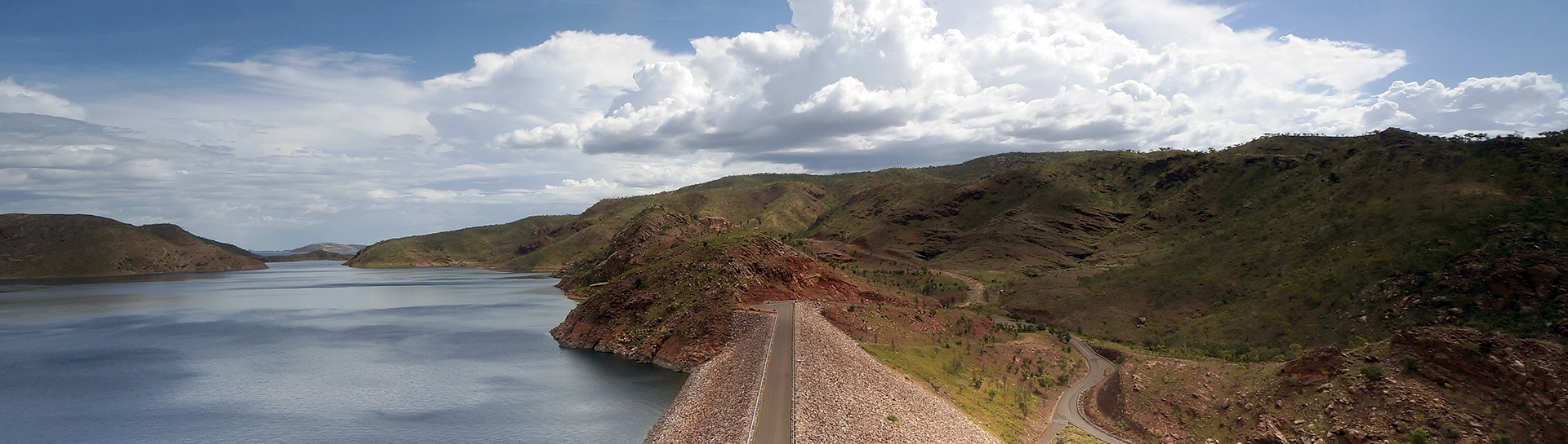
- Lake Argyle and Lake Kununurra, Ramsar-listed wetlands, sustain perennial flows in the lower Ord, enabling hydroelectric generation and supply to the Ord River Irrigation Area.
- Water use is dominated by regulated surface water for irrigation, while groundwater plays a minor, targeted role for town supply and mining.
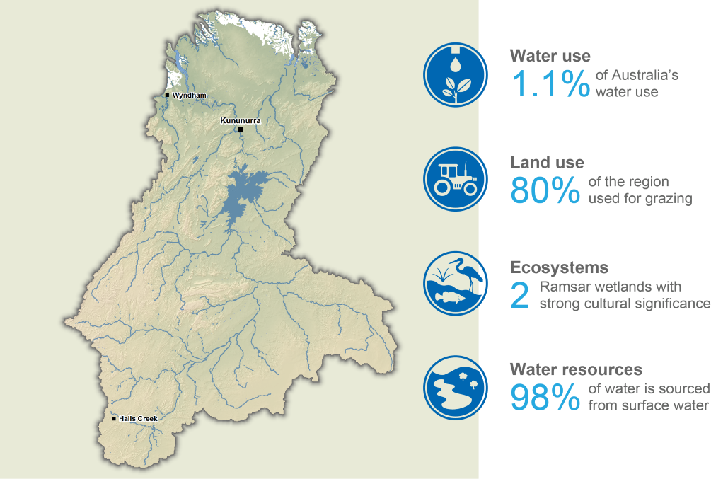
This section provides an overview of the Ord region, including its population, land use, topography, culturally and environmentally significant areas, and water resources, as well as its water management arrangements and water rights provisions.
For further information, scroll down this page or click on the links below:
Geographic information
General information
Area: 65,800 km²
Population: 13,689 (Australian Bureau of Statistics (ABS) 2021 - Ord Region*)
*Includes Kununurra SAL 2, Victoria River SAL 2, and Halls Creek SAL 2
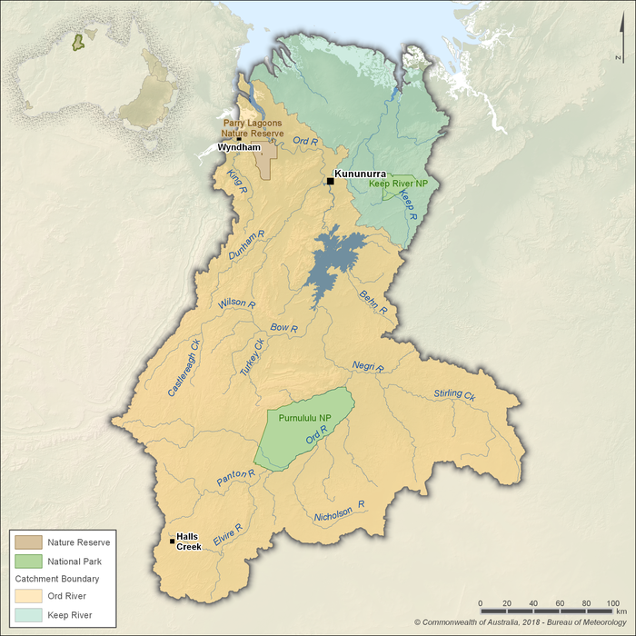
Figure R1 Contextual map of the Ord region
- Located in the East Kimberley, the Ord region spans the border between Western Australia and the Northern Territory.
- The Ord region is defined by two surface water catchments: the Ord River and the Keep River.
- About 1.1% of Australia's total water use occurs in the region, mostly from surface water resources for irrigation purposes.
Land use
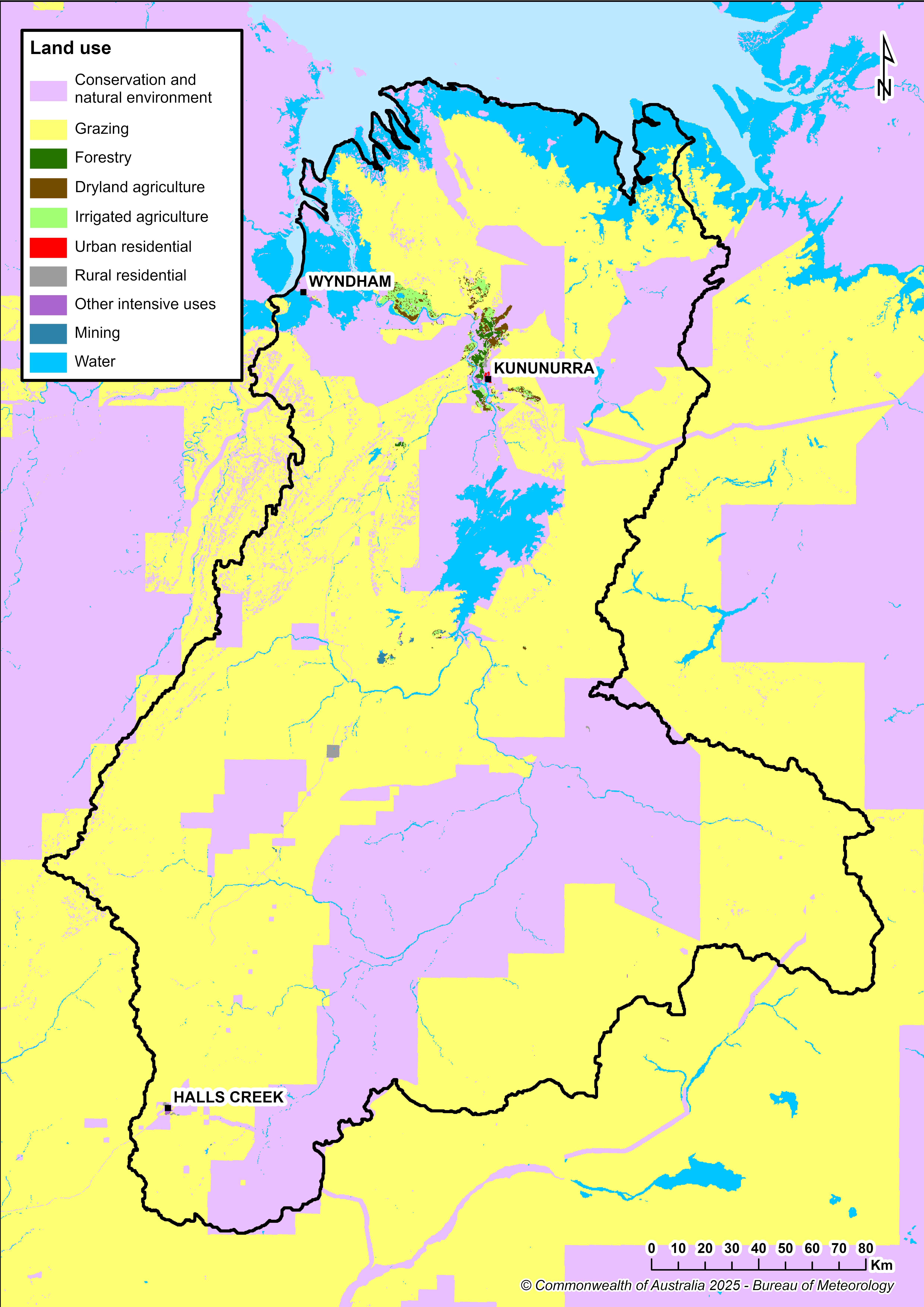
Figure R2 Land use in the Ord region
- Pastoral grazing accounts for almost 80% of the region’s land area, with the remaining 20% comprising conservation areas, including national parks such as Keep River National Park and Purnululu National Park.
- Less than 1% of the land area is used for irrigated agriculture, mainly in the Ord River Irrigation Area downstream of Lake Argyle. Major crops include sandalwood, mahogany, and a range of horticultural crops and grains.
- Mining occupies less than 1% of the land area and includes nickel mining about 120 km north of Halls Creek. The Argyle Diamond Mine near Lake Argyle—the world’s primary source of rare pink and red diamonds—ceased operations in November 2020 and is now undergoing rehabilitation. Once complete, the site will be returned to the Traditional Owners, the Miriwoong and Gija peoples.
- Kununurra serves as the region’s main service and administrative centre, Wyndham operates as the principal port town, and Halls Creek functions as a support hub for surrounding cattle stations and remote communities.
Significant aquatic ecosystems
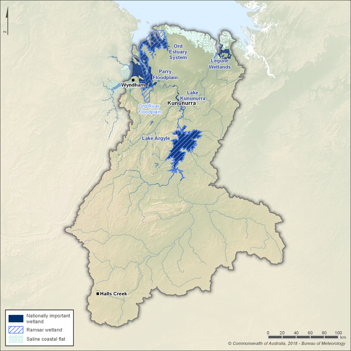
Figure R3 Significant wetlands in the Ord region
- Two Ramsar-listed sites are located within the Ord region: Lakes Argyle and Kununurra and the Ord River Floodplain.
- Both sites are recognised for their international importance under The Convention on Wetlands, supporting extensive wetland habitats such as permanent and seasonal water bodies, mudflats, floodplains, and estuarine zones that provide critical refuge for migratory birds and diverse aquatic species.
- Lake Argyle, Western Australia’s largest and Australia’s second-largest freshwater lake, underpins the ecological character of the Lakes Argyle and Kununurra Ramsar site by sustaining flows to the lower Ord River, maintaining extensive riparian and aquatic ecosystems downstream, including Lake Kununurra.
- Up to 74 waterbird species have been recorded at the Lakes Argyle and Kununurra site, including 22 species listed under international conservation treaties. It also provides habitat for at least 15 freshwater fish species, freshwater crayfish, the native water rat, and three species of freshwater turtle, including the north-western red-faced turtle. The site is also a major breeding area for freshwater crocodiles.
- The Ord River Floodplain Ramsar site is a large floodplain and estuarine system supporting more than 200 species of waterfowl, migratory shorebirds, mangrove birds, and terrestrial fauna. It also provides habitat for the nationally threatened Australian painted snipe.
- Multiple diadromous fish species that migrate between marine and freshwater environments rely on the Ord River Floodplain. Nationally threatened species such as the freshwater sawfish, green sawfish, and northern river shark are found within the area, along with both freshwater and saltwater crocodiles.
- According to the Directory of Important Wetlands in Australia, several nationally important wetlands are also present in the region, including the Ord Estuary System, Parry Floodplain, Lake Kununurra, and Legune Wetlands. These support high biodiversity, providing vital breeding and feeding habitats for many threatened species.
- Groundwater-dependent ecosystems occur in parts of the Ord region, sustained by springs, baseflows, and riparian vegetation that are ecologically significant during dry-season periods.
Significant Aboriginal cultural places
- The Ord region lies on the traditional lands of several Aboriginal peoples, including the Miriuwung and Gajerrong, who hold deep cultural and spiritual connections to its rivers, lakes, and wetlands.
- Dreaming stories are central to the Ord River and continue to sustain cultural practices, ceremonial life, and customary fishing and hunting activities.
- Lake Argyle, created through the damming of the Ord River, flooded many traditional sites but remains a place of continuing cultural significance, symbolising resilience and adaptation for Aboriginal communities.
- Billabongs, springs, and creeks across the Ord region are valued as important living water sources, associated with ancestral beings and ongoing traditional use.
- The Ramsar-listed sites—Lakes Argyle and Kununurra and the Ord River Floodplain—hold particular cultural value, with their abundance of birdlife, fish, and turtles supporting traditional food practices and storylines.
- Wetland areas such as the Parry Floodplain and Ord Estuary are important for customary harvesting of fish and waterbirds, and remain linked to traditional ecological knowledge passed down through generations.
- Freshwater and saltwater crocodiles, abundant in the region’s waterways, also hold cultural significance, appearing in Dreaming stories and continue to influence cultural practices and protocols.
- Protection of cultural sites remains a central focus of joint management arrangements between Traditional Owners and government agencies, ensuring that water planning and land management respect Aboriginal heritage and ongoing cultural values.
Water resources
- Surface water resources account for approximately 98% of total water use in the Ord region, supporting irrigated agriculture, hydroelectric power generation, and self-supply for smaller users.
- Lake Argyle, Australia’s second-largest reservoir, is the primary water asset in the region, regulating flows to the lower Ord River and providing reliable water supply for multiple purposes.
- Groundwater resources are not extensively developed, contributing only a minor share of water use. They are primarily drawn upon for mining operations and town supply.
Surface water
Storages
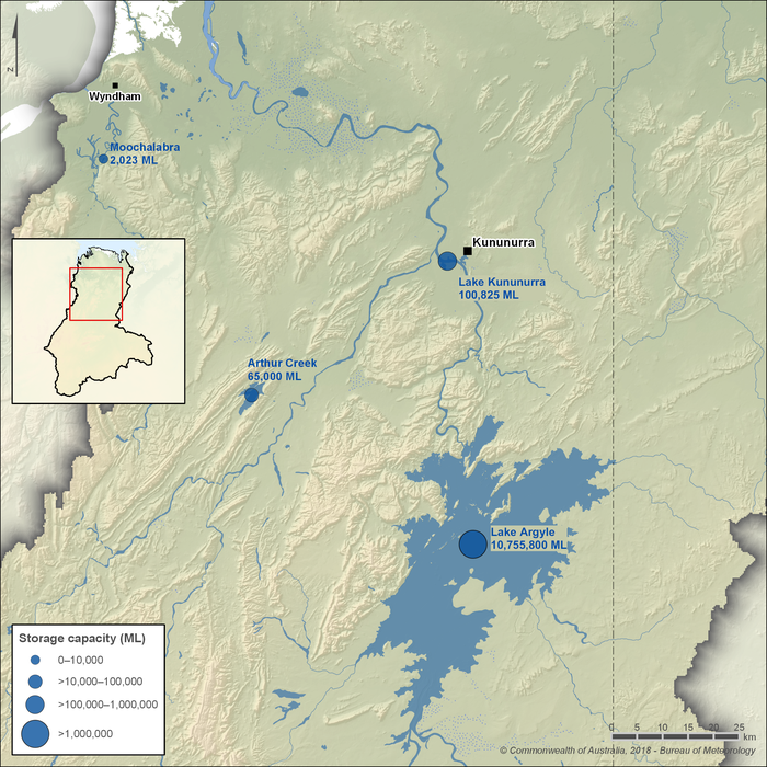
Figure R4 Major storages in the Ord region; capacity of each storage is also shown
- Lake Argyle is the largest storage in the region and the second-largest reservoir in Australia. It regulates the Ord River system, providing secure water for irrigation, hydroelectric power generation, town supply, and environmental flows.
- Water released from Lake Argyle drives hydroelectric power generation before sustaining flows downstream to meet irrigation and environmental requirements in the lower Ord River.
- Lake Kununurra functions primarily as a regulating storage, receiving most of its inflows from Lake Argyle releases. It supplies water to the Ord River Irrigation Area through a network of diversion channels and pumping stations (see Irrigation scheme).
- Together, Lakes Argyle and Kununurra form the foundation of the Ord River Irrigation Scheme, ensuring year-round water reliability for agriculture and other regional demands.
- Additional storages include Arthur Creek, a large private dam used for self-supply irrigation, and Moochalabra Dam, which provides the town water supply for Wyndham.
Rivers
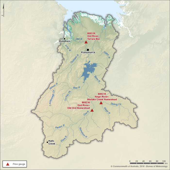
Figure R5 Key flow gauging stations along the main rivers within the Ord region
- The Upper Ord and Negri rivers are the two primary river systems flowing into Lake Argyle, the main storage in the region.
- Three gauging stations (shown in Figure R5) are used to represent seasonal flow patterns: two upstream of Lake Argyle on the Upper Ord and Negri rivers, and one downstream of Lake Kununurra, where regulated releases influence flow conditions.
- Flows upstream of Lake Argyle are typically low during the dry season and can periodically cease altogether.
- In contrast, flows in the Ord River downstream of Lake Kununurra are perennial, sustained by regulated releases from Lake Argyle. These releases maintain minimum environmental flows in the lower Ord River while also supporting hydroelectricity generation, irrigation diversions, dam operations, and storage overflows.
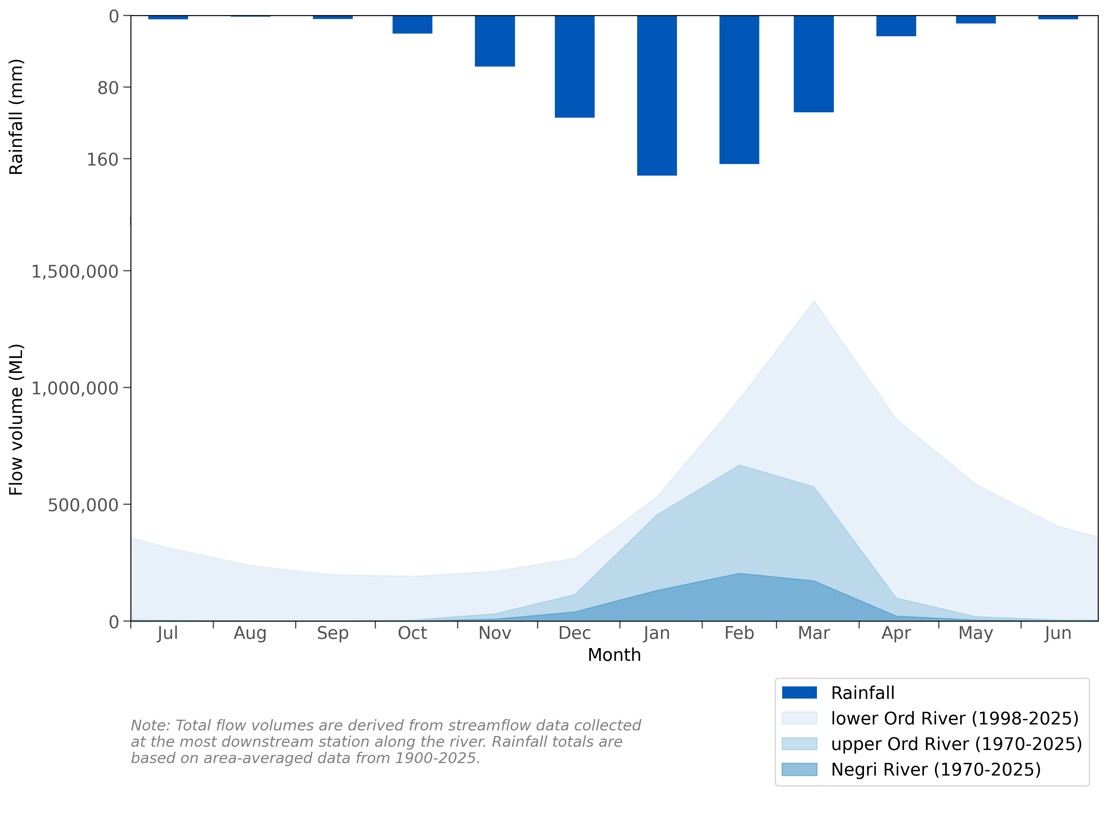
Figure R6 Mean monthly flows along the Ord (upper and lower) and Negri rivers and mean monthly rainfall for the Ord region
- Seasonal flow characteristics of rivers in the Ord region reflect the distribution of rainfall throughout the year, with most of the rainfall occurring during the wet season between November and April. Consequently, most of the streamflow within the region occurs between January and May.
- Upstream of Lake Argyle, flows remain low or sometimes cease to flow during the dry season between May and October.
- The Ord River below Lake Argyle receives specific releases to maintain minimum environmental flows in the lower Ord River. As a result, flow in the lower Ord River is perennial.
- Other rivers in the Ord region exhibit seasonal flow patterns similar to rivers upstream of Lake Argyle.
- In wet-season deluges, the region can experience extensive flooding. Historically, before Lake Argyle’s construction, the Ord River regularly burst its banks, inundating vast floodplains every two to three wet seasons, reshaping riparian ecosystems.
- Further information on climate and streamflow conditions across the Ord region is provided in the Climate and water section of the account.
Groundwater
- Groundwater resources in the Ord region are limited and not extensively developed, reflecting the dominance of surface water storages such as Lake Argyle.
- Localised fractured rock aquifers provide small-scale supplies, providing town water for Halls Creek and several mining operations in the upper Ord catchment.
- Sedimentary aquifers adjacent to Lake Kununurra are used to supply the town of Kununurra, supplementing the extensive surface water system.
- In general, groundwater across the region is highly variable in yield and quality, with productive zones confined to local aquifers rather than extensive regional systems.
Water systems
Irrigation scheme
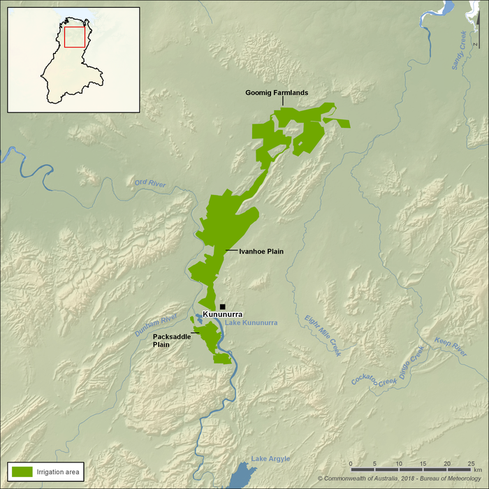
Figure R7 Ord River Irrigation Area
- The Ord River Irrigation Area is a multi-stage agricultural development in the East Kimberley that uses water from the Ord River to irrigate farmland for crops such as mango, chickpeas, and sandalwood.
- Water is delivered to the Ord River Irrigation Area through an open-channel network and accounts for more than 90% of the region’s total surface water entitlements, making it the primary user of regulated water in the Ord region.
- Most irrigation water is diverted from the Ord River at Lake Kununurra via the Kununurra Diversion Dam, with the M1 supply channel conveying flows to the Ivanhoe Plain and Goomig Farmlands. Less than 10% of the water is diverted to the Packsaddle Plain, south of Kununurra.
- Irrigation infrastructure, including channels, drains, and pumping stations, is jointly operated by the Water Corporation of Western Australia and the Ord Irrigation Cooperative to maintain efficiency, ensuring year-round supply regardless of seasonal rainfall.
- The Ord River Irrigation Area is recognised as one of northern Australia’s most significant irrigation districts, underpinning regional agricultural development and associated industries.
- Proposed expansion of the Ord River Irrigation Area is discussed further in the Major water reforms section below.
Major water reforms
Ord-East Kimberley Expansion Project
- Since the 1950s, the long-term vision for the Ord River Irrigation Scheme Project has been to develop all irrigable soils across the greater Ord and Keep River floodplains.
- Expansion beyond the Stage 1 area (supplied by the M1 supply channel) was promoted in the 1990s, culminating in proposals to develop more than 30,000 hectares in what became known as the M2 supply area (also referred to as the Stage 2 area of the expansion area).
- In the early 2000s, the M2 supply area received conditional environmental approval from the Western Australian and Northern Territory Governments. Although the initial project lapsed, approvals remained in place, paving the way for future expansion.
- The Western Australian Government launched the Ord–East Kimberley Expansion Project in 2008, committing to develop 7,400 hectares in the Goomig Farmlands—the first phase of the broader M2 supply area. Construction of off-farm infrastructure began in 2010, with Kimberley Agricultural Investment Pty Ltd later appointed as the preferred developer, and was completed by the end of 2013.
- Proposals have since expanded the M2 supply area to other development zones including Knox Creek Plain, Carlton and Mantinea Plains, the Ord West Bank, and smaller parcels such as the Ord East Bank and the greater Packsaddle Plain area.
- Expansion into the Northern Territory's Keep River Plains (supplying up to 14,000 hectares of irrigable lands) remains subject to further Northern Territory and Commonwealth approvals, but forms part of the long-term expansion vision, detailed under Stage 3 of the expansion project.
- Investigations are also ongoing into the Cockatoo Sands area, where up to 6,000 hectares may be suitable for groundwater-based irrigation.
- Together, these proposals represent a staged pathway for irrigation expansion, with progress dependent on environmental approvals, infrastructure readiness, investor demand, and water allocation limits set under the Ord Surface Water Allocation Plan.
- If all proposed developments proceed, the total irrigated footprint of the Ord River Irrigation Area could reach up to 60,000 hectares.
Ord River Irrigation Strategy 2024-34
- In 2024, the Western Australian Government released the Ord River Irrigation Strategy 2024–34, setting a 10-year vision to expand irrigated farmland to as much as 50,000 hectares.
- Cotton has been identified as an emerging dominant crop, supported by the planned completion of a cotton gin at Kununurra in 2025, while horticultural, grain, and forestry crops such as sandalwood remain important in the production mix.
- The strategy emphasises sustainable land and water use, with a focus on drainage management, soil protection, and maintaining water quality for downstream ecosystems.
- Regional development priorities include investment in processing facilities, supply-chain infrastructure, and workforce skills to support a more resilient and value-adding agricultural economy.
- Strong partnerships with Traditional Owners and local communities are central to the strategy, embedding employment pathways, cultural engagement, and shared benefits into future development.
- Implementation of the strategy will be staged to align with infrastructure readiness, investor demand, and water availability, ensuring that expansion proceeds in a managed and sustainable way.
Water management
Surface water and groundwater management
Water legislation
- Water management in the Ord region is governed by two primary legislative frameworks: Western Australia’s Rights in Water and Irrigation Act 1914 and the Northern Territory’s Water Act 1992.
- The Rights in Water and Irrigation Act provides for the proclamation of water management areas and watercourses, establishes licensing requirements for taking water, and underpins allocation planning and regulation of irrigation schemes in Western Australia.
- The Water Act sets out similar provisions for the Northern Territory, providing for the declaration of water control districts, allocation planning, and licensing of surface water and groundwater use, with the Water Regulations 1992 providing further legislative support to the Water Act.
- Responsibility for administering the Acts lies with the Western Australian Department of Water and Environmental Regulation and the Northern Territory Department of Lands, Planning and Environment, which support their respective ministers in carrying out statutory functions.
- Together, these instruments provide the legislative basis for allocating water entitlements, setting sustainable extraction limits, and regulating both surface water and groundwater use across the Ord region.
Water allocation plans
- The Western Australian Department of Water and Environmental Regulation oversees the Ord Surface Water Allocation Plan, which sets out how surface water is allocated and licensed to balance irrigation, hydroelectricity generation, urban supply, and individual users.
- Provisions in the plan recognise the region’s environmental, social, and cultural values, ensuring sufficient water is retained to sustain aquatic ecosystems while meeting specific cultural and social needs.
- Groundwater allocation plans have not yet been developed for the Ord region, reflecting the limited use of groundwater compared with the abundance of surface water resources.
- Water management areas in the Ord region are defined in the Ord Surface Water Allocation Plan (as shown in Figure R8 below), which provides the framework for regulating and monitoring licences water use.
Water management areas
Surface water
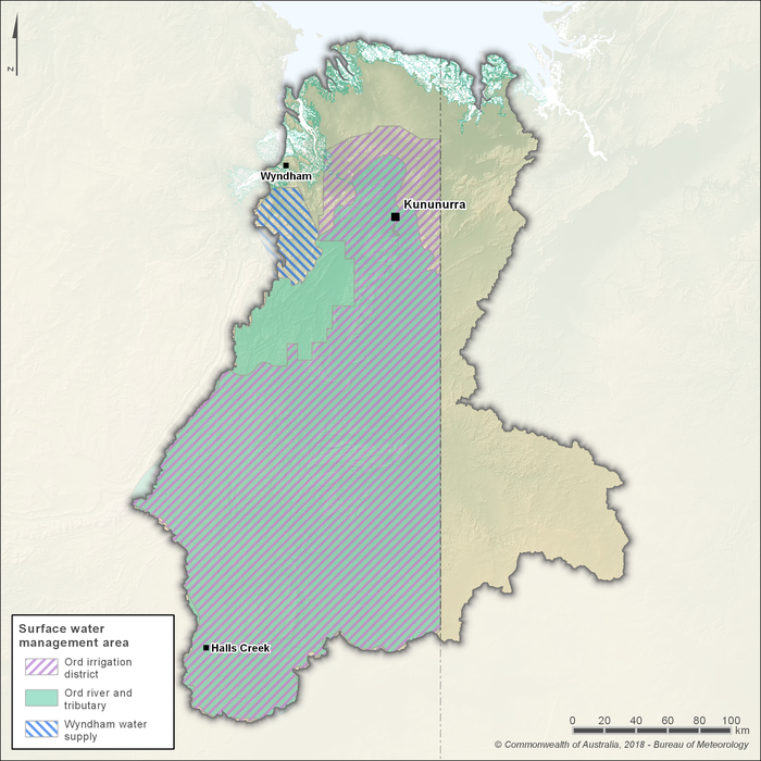
Figure R8 Surface water management areas in the Ord region
- The Ord Surface Water Allocation Plan defines five Western Australian surface water subareas used for licensing and regulation (as shown in Figure R8), including the Upper Ord, Main Ord, Dunham River, Tarrara–Carlton, and Carlton–Mantinea sub areas which sit within the Ord River and Tributary Surface Water Management Area.
- Outside the allocation plan area, Wyndham’s town water supply is managed under the Moochalabra Catchment Area Water Source Protection Plan, defined by the Moochalabra catchment area.
- Areas of the broader Ord region lying in the Northern Territory are not covered under any allocation plan, but instead are managed under the Northern Territory's Water Act 1992.
- Where no jurisdictional allocation plan is in place, such as for parts of the Ord River floodplain in Western Australia and the Keep River catchment in the Northern Territory, water use is still regulated under the relevant jurisdiction’s legislation and licensing provisions.
- For the National Water Account, the Ord region boundary reflects the full Ord and Keep River catchments, which extends beyond the Ord Surface Water Allocation Plan boundary.
- Within the Ord Surface Water Allocation Plan area, licensed surface water use—including irrigation releases, hydroelectricity generation, and environmental flows—is administered by the Department of Water and Environmental Regulation under the Rights in Water and Irrigation Act 1914.
Groundwater
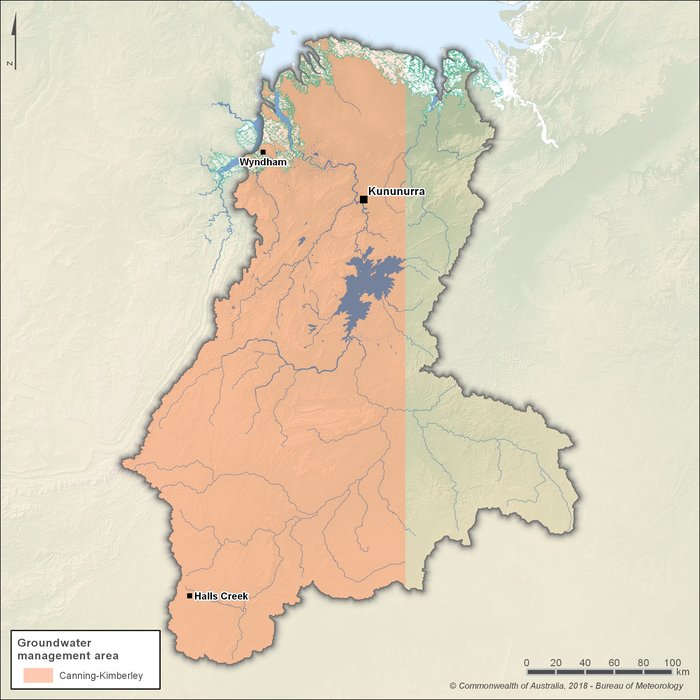
Figure R9 Groundwater management areas in the Ord region
- Groundwater in the Western Australian portion of the Ord region is managed within the Canning–Kimberley Groundwater Area (as shown in Figure R9), proclaimed under the Rights in Water and Irrigation Act 1914.
- Within this proclaimed area, the Department of Water and Environmental Regulation licenses the taking of groundwater and the construction of works, applying conditions suited to localised aquifer settings such as those around Lake Kununurra, Halls Creek, and mining districts.
- No groundwater management areas are proclaimed in the Northern Territory portion of the Ord region. Instead, extractions are regulated through licensing provisions defined in the Northern Territory's Water Act 1992.
- Given the limited development of groundwater in the Ord region, no allocation subareas or groundwater allocation plans have been established. Licensing is generally assessed on a case-by-case basis.
- Monitoring and compliance efforts are concentrated on operational and town-supply borefields, with ongoing investigations supporting proposed developments, while broader ecological considerations are addressed in the Significant aquatic ecosystems section.
Water management programs
- The National Water Agreement builds on the National Water Initiative to provide a federal-state framework for water reform across Australia. It sets principles for sustainable water use, efficient allocation, transparent water rights registers, and includes modules for climate risk and Indigenous inclusion.
- Water Security for Northern Australia is a research-and-stakeholder program led by the Cooperative Research Centre for Developing Northern Australia and the Northern Australia Universities Alliance. For the Ord River Irrigation Area, it focuses on issues such as water quality (especially runoff), ecological impacts (including assessment of species in the Keep River catchment), and stakeholder values around water use during dry periods.
- Under the Water Security for Northern Australia, specific projects targeting the Ord River Irrigation Area include understanding how agricultural runoff impacts water quality in the Keep River, mapping the ecological impacts of flood and runoff events on species of concern (e.g. sawfish), and exploring how water is valued by different stakeholders—particularly in years of water scarcity.
- The Ord River Expansion to the Northern Territory Detailed Business Case, funded under the National Water Grid Fund, is assessing the feasibility and economic returns of extending the Ord River Irrigation Area infrastructure into Northern Territory precincts such as the Keep River Plains, evaluating both infrastructure needs and water-supply sustainability.
- Western Australia’s Ord River Irrigation Area Strategy 2024-34 is a state-led program aiming to scale up agricultural development in the Ord River Irrigation Area to approximately 50,000 hectares over the next 10 years. It includes components of land and water planning, workforce development, research and development, value-added processing, and more inclusive engagement with Traditional Owners.
- Regional development programs in Western Australia (past and ongoing) also include infrastructure investment (channel upgrades, off-farm works, farm block servicing) under the Ord-East Kimberley Expansion Project, which are in part enabled or guided by these research/strategy programs and planning efforts. For example, funding via state and federal government grants aligned with the Ord River Irrigation Area Strategy 2024-34.
Environmental water management
- Western Australia’s Environmental Water Provisions Policy guides how environmental water is identified and set in allocation planning, including defining ecological water requirements and the trade-offs considered in decision-making.
- The Ord Surface Water Allocation Plan establishes environmental water provisions for the lower Ord River to protect riverine condition, riparian habitats, wetlands, and estuarine values.
- Releases from Lake Argyle and Lake Kununurra are operated to meet these environmental water provisions, maintaining specified minimum flows and seasonal patterns in the lower Ord, while coordinating with irrigation delivery and hydroelectric generation.
- Flow compliance is monitored by the Department of Water and Environmental Regulation at key gauging locations in the lower Ord River (for example, at downstream sites such as Tarrara Bar), with results used to verify performance against plan rules.
- Operating rules and release protocols are implemented by the Water Corporation of Western Australia under arrangements that specify environmental flow targets, reporting requirements, and procedures for managing operational contingencies.
- Adaptive management underpins the framework through monitoring results, ecological condition assessments, and stakeholder inputs during periodic reviews of plan provisions to ensure environmental outcomes continue to be met.
Cultural water management
- The Ord Surface Water Allocation Plan incorporates cultural water provisions that recognise the values and interests of the Miriuwung and Gajerrong peoples, particularly in relation to the lower Ord River.
- Short periods of very low flow, or ‘dry out’ events, hold significance in Dreaming stories and cultural practices. Since the construction of Lake Argyle and Lake Kununurra, these events have become rare, generally occurring only when dam maintenance or inspections are undertaken.
- The Department of Water and Environmental Regulation and the Water Corporation of Western Australia have an obligation to advise the Miriuwung and Gajerrong peoples in advance of such events, enabling traditional activities to be undertaken when they occur.
- Cultural water considerations are also supported through Indigenous Land Use Agreements and joint management arrangements in the Ord region, which ensure that Traditional Owners are involved in water planning processes and that cultural values are reflected in management decisions.
Organisations responsible for water management
- Western Australia’s Department of Water and Environmental Regulation and the Northern Territory’s Department of Lands, Planning and Environment set the legislative and planning framework—covering allocation planning, licensing, compliance, and environmental and cultural water provisions—across their respective jurisdictions.
- Water Corporation of Western Australia operates the major storages and river regulation assets (e.g., Lake Argyle and the Kununurra Diversion Dam), delivering release regimes that meet environmental flow targets, while supporting irrigation and hydropower operations.
- Ord Irrigation Cooperative manages water distribution within the Ord River Irrigation Area—scheduling and delivering water via channels, pumps and drains, maintaining assets, and reporting on operational performance.
- Further detail on the roles and responsibilities of water management organisations in the Ord region is provided in Table R1.
| Organisation | Responsibilities |
| Western Australian Government |
|
| Northern Territory Government |
|
| Department of Water and Environmental Regulation |
|
| Department of Lands, Planning and Environment |
|
| Water Corporation |
|
| Ord Irrigation Cooperative |
|
| Department of Primary Industries and Regional Development |
|
| Cooperative Research Centre for Developing Northern Australia |
|
| Northern Australia Universities Alliance |
|
| MG Corporation |
|
| Department of Biodiversity, Conservation and Attractions |
|
| Department of Climate Change, Energy, the Environment and Water |
|
| Environmental Protection Authorities - WA EPA - NT EPA |
|
| Shire of Wyndham-East Kimberley |
|
| Pacific Blue - Ord Hydro Plant |
|
Water rights
Operating rules and constraints
- The Department of Water and Environmental Regulation regulates the taking of surface water in the Ord Surface Water Allocation Plan area through allocation planning and licensing. Water may only be taken under an issued licence within designated management subareas. Licensing of water in the Northern Territory portion of the Ord region is regulated under the Water Act 1992.
- Chapter 5 of the Ord Surface Water Allocation Plan sets the licensing framework and operating rules for hydroelectric generation, irrigation, environmental water, and self-supply, detailing how rules apply in both normal and dry years.
- Licence conditions are tailored to user categories and integrate ordering, delivery, and reliability within plan limits.
- Releases from Lake Argyle and Lake Kununurra follow specified release rules linked to storage conditions, coordinating hydropower generation with irrigation deliveries and required environmental flows in the lower Ord.
- Environmental water provisions are implemented through licence conditions that specify minimum or baseflows, seasonal patterns, and event-based targets at key compliance locations such as Tarrara Bar. Streamflow monitoring at these sites is used to verify performance against plan-specific targets.
- Adaptive provisions allow the review and amendment of key licences and operating rules as development proceeds, aligning with the staged expansion described in the Major water reforms section.
Water entitlements and other statutory water rights
- Water entitlements are administered through licences that specify purpose, maximum annual volume, conditions, and tenure. In Western Australia, the Department of Water and Environmental Regulation applies these in the Ord Surface Water Allocation Plan area, while in the Northern Territory, they are administered by the Department of Lands, Planning and Environment.
- Entitlements are determined within allocation limits and subareas defined by the Ord Surface Water Allocation Plan, with conditions tailored to the use category, reliability objectives, and any local operating constraints.
- Under the Rights in Water and Irrigation Act 1914, the Water Corporation holds a licence to operate the Ord River Dam and the Kununurra Diversion Dam. Conditions govern storage levels and release rules to meet environmental water provisions in the lower Ord while facilitating hydropower and downstream supply.
- Also under the Rights in Water and Irrigation Act, the Ord Irrigation Cooperative holds a licence to divert water from Lake Kununurra for distribution within the Ord River Irrigation Area, including non-potable commercial use in areas serviced by the Stage 1 channel systems. Conditions typically address ordering and delivery, metering, efficiency, and drainage requirements.
- Other licensed entitlements in the region include town supply, mining and industrial uses, and smaller self-supply users. These licences set works approvals, metering and reporting requirements, and any water-quality or discharge conditions needed to protect downstream values.
- In addition to licences, legislation provides limited statutory rights and exemptions, such as domestic and stock use where permitted in addition to emergency firefighting. These rights are subject to plan rules and cultural and environmental protections, and do not override licensing requirements where a licence is required.
Water allocations
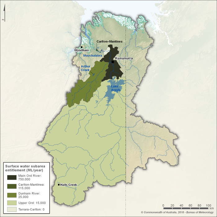
Figure R10 Annual water entitlements for surface water resource areas of the Ord region
- The Ord Surface Water Allocation Plan applies to the Western Australian portion of the Ord region and divides it into five surface-water subareas (as shown in Figure R10), including the Upper Ord, Main Ord, Dunham River, Tarrara–Carlton, and Carlton–Mantinea subareas.
- Environmental water provisions and entitlement limits are set in each subarea, allowing for the sustainable use of water across the entire Ord region, without compromising environmental ecosystems.
- More than 95% of entitlements are located in the Main Ord and Carlton–Mantinea subareas downstream of Lake Argyle. No entitlements are issued directly for the Tarrara–Carlton subarea due to unsuitable soils and topography which cannot accommodate irrigation development.
- Annual allocations are determined for each subarea by the Department of Water and Environmental Regulation, reflecting storage conditions and plan rules. Announcements are made to licensees in April each year.
- Groundwater entitlements are administered separately by the Department of Water and Environmental Regulation, and include town supplies for Kununurra and Halls Creek.
Trades and water rights transfers
- Under the Rights in Water and Irrigation Act 1914, licences and entitlements may be traded or transferred within the same water management area, subject to regulatory approval and statutory tests to ensure no adverse impact on other users or the environment.
- Trades between different areas are not permitted and must generally involve the same resource and compatible use category. All existing metering, reporting, and works conditions continue to apply to the new licence holder.
- Within the Ord River Irrigation Area, Cooperative members may trade allocations in line with the Cooperative’s rules and governance framework. Trades with external parties are not permitted.
- Transfers of licence ownership, such as with a land sale, are permitted subject to regulator approval and due diligence, but entitlement volumes and conditions remain bounded by subarea limits and plan provisions.
- In the Northern Territory portion of the Ord and Keep systems, trades and transfers are governed by the Water Act 1992 and Water Regulations 1992. Trading in the Northern Territory is limited and assessed case by case given the low level of licensed development.