


This brochure describes the flood risk and previous flooding in the Balonne River catchment, last updated in October
2025. Note this brochure refers to the Balonne River between Warkon and the NSW Border, and the Maranoa River. For
information on the Condamine River please see the relevant brochure.
Flood Risk
The Condamine-Balonne River system is one of the major tributaries of the Murray-Darling River system and is one of the most important river systems in Queensland in terms of agriculture. The headwaters of the Condamine-Balonne River rise in the Border Ranges upstream of Killarney and flow for approximately 1200 kilometres through Queensland before entering New South Wales.
The Balonne River has a number of important tributaries, including Bungil Creek which flows through Roma before joining the Balonne River near Surat. The Maranoa River is another major tributary and has headwaters located in the Carnarvon Ranges, flowing south through Mitchell before joining the Balonne River at Beardmore Dam. Further downstream, the Balonne River passes through St George, then shortly upstream of Dirranbandi splits into the Culgoa and Balonne Minor Rivers. The Culgoa forms the western branch, and the eastern branch continues on as the Balonne River through Dirranbandi. Shortly after flowing through Dirranbandi, the Balonne River again branches into the Bokhara River to the west and the Narran River to the east. The Narran River flows into Narran Wetlands.
Smaller tributaries of the Balonne can experience rapid flooding with limited forecast lead time during heavy rainfall events, including Bungil Creek through Roma. However, the Balonne River typically experiences slower flooding, with peaks taking many days to pass through the system and multiple peaks often observed. In the lower catchment where the river splits into numerous channels, flooding can continue for weeks along the vast flat flood plains. It takes roughly one week for flood waters to travel from St George to Dirranbandi. Downstream of Dirranbandi, water harvesting can significantly delay the onset of floods and reduce flood heights and volume, especially for low volume floods.
While major flooding on the Balonne River often develops in the upper part of the catchment from the Condamine River, major flooding can also result from heavy rainfall in any of the large tributaries which enter the main Balonne River. In 1990, the Maranoa River experienced a major flood which extended to the NSW border. However, there was no significant flooding in the main Balonne system. Under these circumstances flood forecast lead times may be shorter.
The most significant effects of flooding along the Balonne River are the widespread inundation of agricultural land, the isolation of rural homes and properties and the loss and damages suffered in these areas. Damage to fencing, pumping equipment, machinery and loss of stock through drowning result in significant losses during major floods. Flooding can also be beneficial to significant water storages along the river and provide vital water supply for cropping in the region.
Previous Flooding
In the Balonne River system, major floods generally occur during the summer wet season and the months immediately following. However, flood events have historically been recorded across most months.
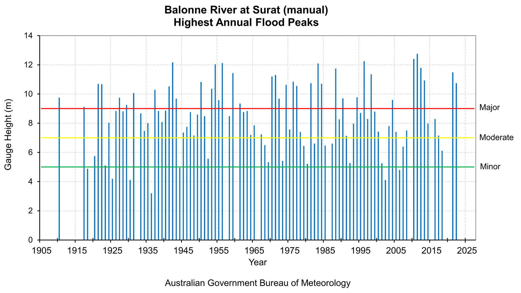
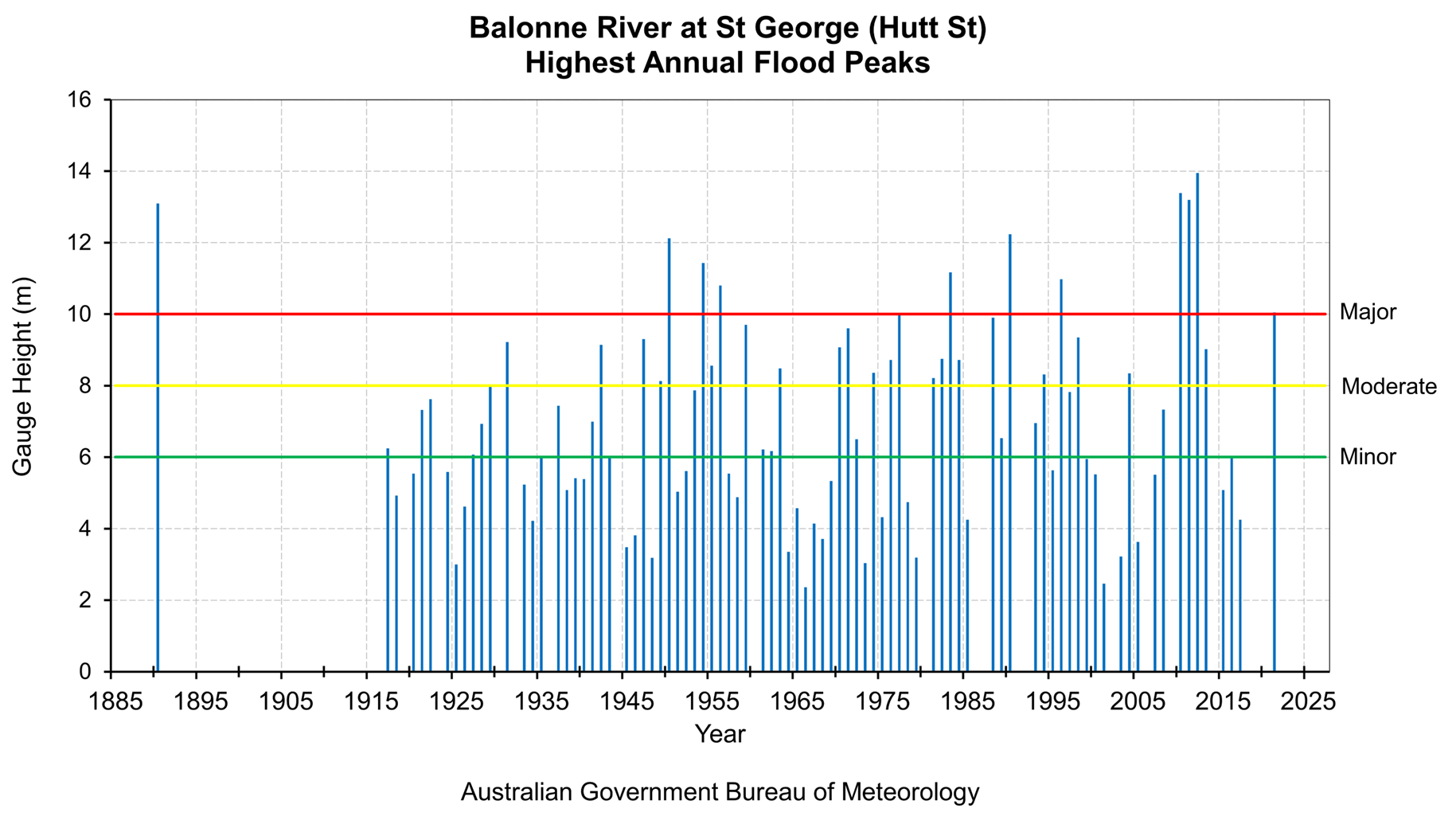
Records of large floods along the Balonne River extend back as far as 1890 at St George with extensive records at several other locations along the main stream. Major floods occur along the river regularly, on average every 2 years.
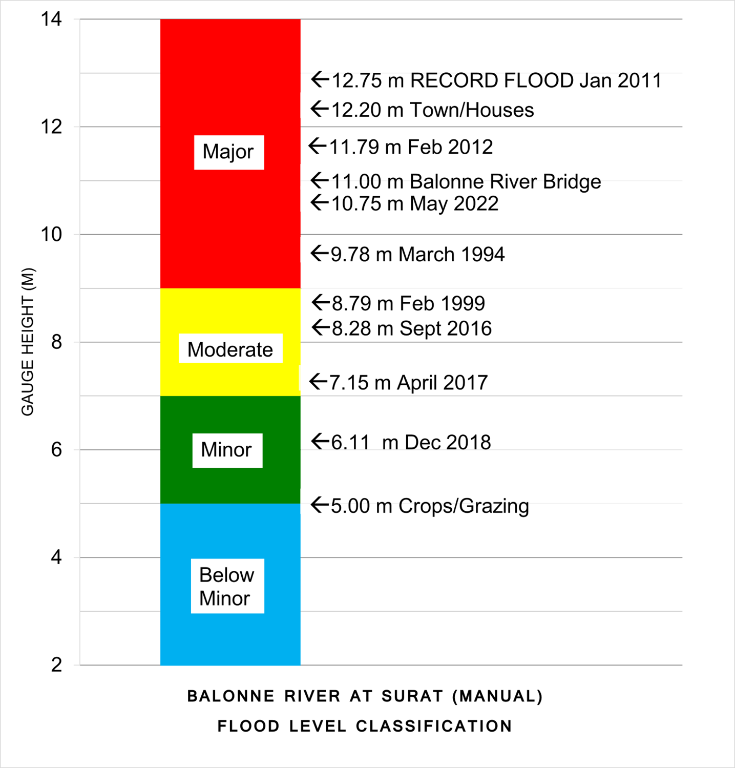
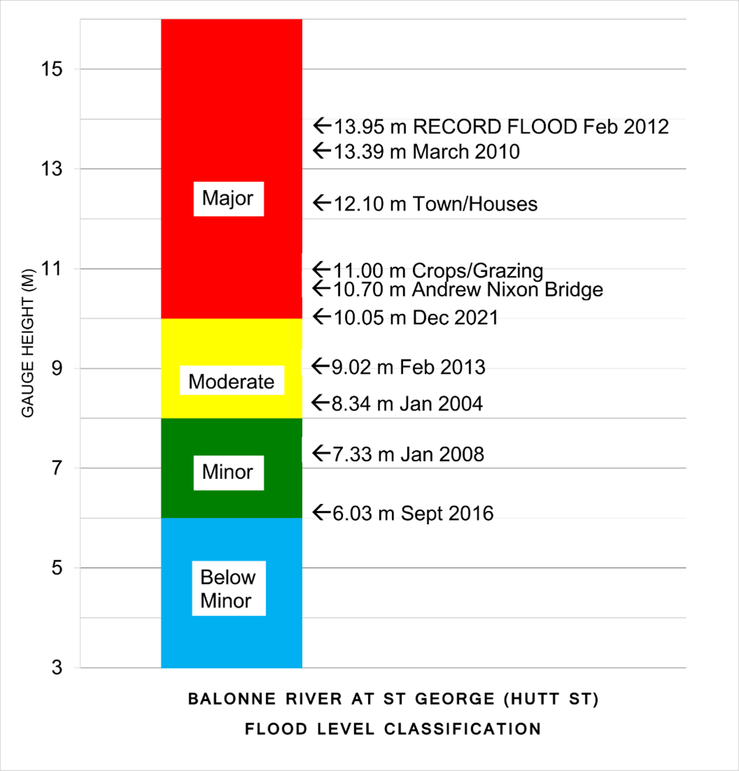
Major flood events were recorded in 1942, 1950, 1956, 1975, 1976, 1983 (twice), 1988 and 1996. Record major flooding was recorded across the Balonne in March 2010 and exceeded in several locations in January 2011 as part of devastating floods that occurred across broad swathes of Queensland, producing widespread inundation, property damage and transport disruption for several weeks.
Further major flooding was recorded in January/February 2012, producing record flood levels at Roma, Mitchell, St George and Dirranbandi, exceeding levels recorded in both 2010 and 2011. The 2012 floods inundated over 400 homes in Roma alone. Since 2012, substantial flood mitigation works have occurred at Roma with the construction of a levee and diversion works, reducing the flood risk for many properties.
The river level gauge at St George Hutt St (station number 043053) is a manual gauge with no peak river level heights recorded for the 2022 and 2024 floods. The nearby Balonne River at St George automatic gauge (station number 043104) recorded peaks of 8.58 m in May 2022 and 7.59 m in April 2024. Note that these two gauges are not an official composite group and so cannot be used as equivalents for comparison.
The table below summarises the flood history of the Balonne River catchment with flood gauge heights of some of the more significant recent floods.
Select past flood peak heights on the Balonne River.
| Flood Event | Warkon | Surat | Warroo | St George (Hutt St) | Dirranbandi | Hebel |
| Feb 1942 | 12.50 | 11.68* | 14.10 | 9.14* | 5.08 | - |
| Jan/Feb 1956 | 11.70 | 12.12* | 14.36 | 10.80* | 5.16 | - |
| May 1983 | 11.67 | 12.09* | 14.17 | 11.17 | 5.14 | 2.30 |
| Apr 1990 | 8.74 | 9.69 | 11.75 | 12.24 | 5.20 | 2.18 |
| Jan 1996 | 11.88 | 12.25 | 13.70 | 10.98 | 5.12 | 2.25 |
| Mar 2010 | 11.62 | 12.40 | 14.37 | 13.39 | 5.25 | 2.34 |
| Jan 2011 | 12.03 | 12.75 | 15.06 | 13.20 | 5.34 | 2.37 |
| Jan/Feb 2012 | 10.64 | 11.79 | 13.80 | 13.95 | 5.45 | 2.44 |
| Feb 2020 | - | - | 12.65 | 12.22 | 5.13 | 2.15 |
| Nov/Dec 2021 | 11.31 | 11.48 | 12.16 | 10.05 | 5.17 | - |
| Mar - May 2022 | 10.78 | 10.75 | 10.37 | - | 5.06 | 1.91 |
| Feb - Apr 2024 | 9.61 | - | 8.36 | - | - | 1.05 |
All heights are in metres on flood gauges.
[*] These heights have been taken at old gauge sites and may not relate to existing gauge sites.
Select past flood peak heights on the Mitchell River and Bungil Creek:
| Flood Event | Roma | Mitchell | Woodlands | Springfield |
| Jan/Feb 1956 | 7.09* | 7.00 | - | 10.17 |
| Apr 1956 | - | 9.26 | - | - |
| May 1983 | 6.90 | 4.66 | 7.1 | 9.96 |
| Apr 1990 | - | 8.47 | 7.25 | 9.65 |
| Mar 2010 | 8.10 | 7.50 | 7.40 | 10.92 |
| Jan/Feb 2012 | 8.40 | 9.84 | 7.80 | 11.38 |
| Feb 2020 | 4.57 | 3.2 | 7.10 | 10.15 |
| Sep 2022 | 4.74 | - | 5.85 | 6.35 |
| Feb - Apr 2024 | 4.46 | 2.13 | - | 6.10 |
All heights are in metres on flood gauges.
[*] These heights have been taken at old gauge sites and may not relate to existing gauge sites.
Further Information:
- Latest rainfall and river heights
- For information on the flood warning service for the Balonne River: Queensland Service Level Specification
- Catchment map: Queensland Balonne-Maranoa map
- National Arrangements for Flood Forecasting and Warning
- Surat Flood Factsheet Dec 2010 Jan 2011
- St George Flood Factsheet Dec 2010 Jan 2011