


This brochure describes the flood risk and previous flooding in the
Nicholson River catchment, last updated in August 2025.
Flood Risk
The Nicholson River catchment is located in northwest Queensland and covers an area of about 53,200 square kilometres. The river rises on the Barkly Tableland in the Northern Territory, 300 kilometres northwest of Camooweal. It flows in a general easterly direction, across the State border. The Gregory River, its major tributary, rises 50 kilometres east of Camooweal and flows in a northerly direction joined by the O'Shanassy River, just downstream of Riversleigh and Lawn Hill Creek, 70 kilometres downstream of Gregory Downs. The Nicholson River is joined by the Gregory River to the southwest of Burketown. The river finally passes through a vast open coastal plain before entering the Gulf of Carpentaria. Floods normally develop in the headwaters of the Nicholson and Gregory Rivers and its major tributaries; however, general heavy rainfall events can develop typically from monsoonal and cyclonic influences which can result in widespread flooding, particularly in the lower reaches below Gregory Downs.
Breakout flows can be complex, Burketown Airstrip is adjacent to the Albert River and not part of the main Nicholson River channel. Flows from all rivers may also need to be considered when determining peak flows and timings. Areas around Doomadgee can be prone to rapid responses during heavy rainfall events.
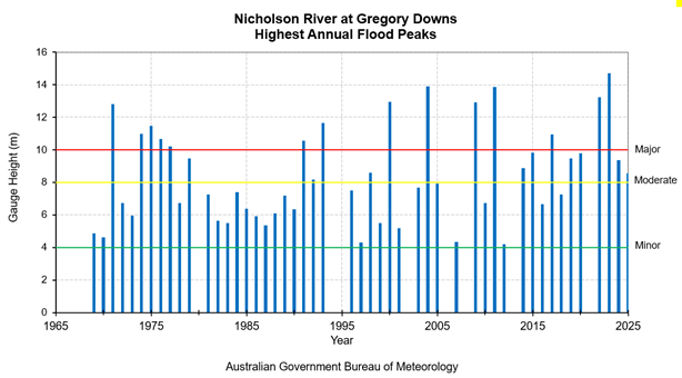
Previous Flooding
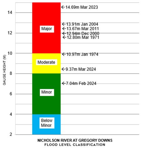
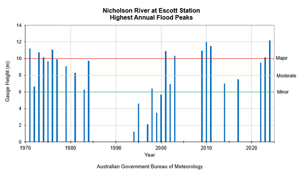
Previous flood information for the Nicholson River is limited. Peak heights are available since the early 1970's for some of the gauging stations. However, for most stations records generally range from 20 to 30 years. Some of the most notable major flood events occurred in 1971, 1974, 2009, 2010, 2011, 2023, and 2024 and to a lesser extent in 1973, 2000, 2001, 2003, 2004 and 2022.
More recently in March 2023, widespread heavy rainfall associated with a slow moving tropical low resulted in unprecedented flooding across parts of far northwestern Queensland. Some locations along the Nicholson, Gregory and Albert River systems experienced record-breaking flooding, surpassing previous record flood heights set back in the notable flood events of 2011 and 1971. A record flood peak of 18.00 metres was recorded at Riverleigh. Unfortunately, the flood level gauge near the Burketown Airstrip was destroyed during this flood event, hence no actual official historical peak flood height data is available from this particular site. Widespread flooding resulted in prolonged disruption and isolation of communities along with inundation of properties across much of the catchment and prompted evacuations in the townships of Doomadgee and Burketown.
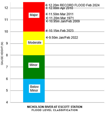
Major flooding also occurred in 2024 and was most notable on the lower reaches of the catchment. A record flood height of 12.00 metres was recorded at Escott Station, surpassing the previous record of 12.00 metres set in April 2010.
The table below summarises the flood history of the Nicholson River catchment - it contains the flood gauge heights of the more significant recent floods.
| Flood Event | Doomadgee Township (m) | Riversleigh (m) | Gregory Downs (m) | Escott Station (m) | Burketown Airstrip (m) |
| Mar 1971 | - | 10.80 | 12.80 | 11.20 | - |
| Jan 1974 | 9.15 | 9.18 | 10.97 | 10.13 | - |
| Dec 2000 | 6.00 | 12.94 | 12.94 | - | 6.55 |
| Mar 2001 | 6.10 | - | - | 10.90 | - |
| Jan 2004 | - | 13.91 | 13.91 | - | 5.40 |
| Jan/Feb 2009 | 4.20 | 8.73 | 12.90 | 10.95 | 6.60 |
| Jan - Apr 2010 | 7.30 | 2.98 | 6.73 | 12.00 | 6.74 |
| Mar 2011 | 4.35 | 9.30 | 13.87 | 11.50 | 6.78 |
| Jan/Feb 2022 | 2.60 | 9.87 | 13.23 | 9.50 | 5.40 |
| Mar 2023 | 8.54 | 18.00 | 14.69 | 10.15 | - |
| Feb 2024 | 7.34* | 10.93 | 7.57 | 12.20 | - |
All heights are in metres on flood gauges.
*Doomadgee TM site used for flood peak reference height in 2024
#Note: The Burketown Airstrip gauge was destroyed during the March 2023 floods, so no peak height flood data is available from this particular site for the flood events of 2023 and 2024.
Further Information:
- Latest rainfall and river heights
- For information on the flood warning service for the Nicholson River: Queensland Service Level Specification
- Catchment map: Queensland Leichhardt, Nicholson, Settlement Rivers map
- National Arrangements for Flood Forecasting and Warning