


This brochure describes the flood risk and previous flooding in the Ross River catchment, last updated in July 2025.
Flood Risk
The Ross, Bohle, and Black River catchments cover the area surrounding Townsville, with headwaters arising in the Hervey Ranges, before flowing northeast across the coastal plains into the Coral Sea.
The Ross River catchment covers an area of 750 square kilometers. Two main tributaries drain the Ross catchment into Ross River Dam; Central Creek flows from the west and Ross River from the South. Central Creek flows into the Ross River just upstream of the Ross River Dam. The Ross River Dam was constructed in 1971 for the dual purposes of flood mitigation and water storage. The dam has a capacity of 233 000 megalitres and is designed to hold 1,200,000 megalitres of water during a flood event. Downstream of the dam, the Ross River continues on its course, flowing into the sea near the Port of Townsville with the adjacent distributary channel Ross Creek draining into the Townsville Harbour.
The Bohle River catchment is approximately 355 square kilometres. The Bohle River drains most of the coastal plains immediately west of the Townsville City area. The floodplain adjoining the Bohle River channel is subject to flooding. In the past, flooding has been worsened by overland flows from the Ross River. However, construction of the Ross River Dam in 1971 has reduced the potential for flood overflows, though these will still occur during significant major flooding.
The Black River and its tributary, the Alice River, drain the area to the west of Deeragun. Several smaller creeks drain areas further north along the coast, including Bluewater Creek, which has a history of flash flooding.
Flooding on the Ross, Bohle and Black Rivers is confined mainly to the northern Australia wet season (October to April). Significant floods have historically been driven by either a tropical cyclone impacting the region or, more commonly, the monsoon trough stalling in the area for a number days.
Previous Flooding
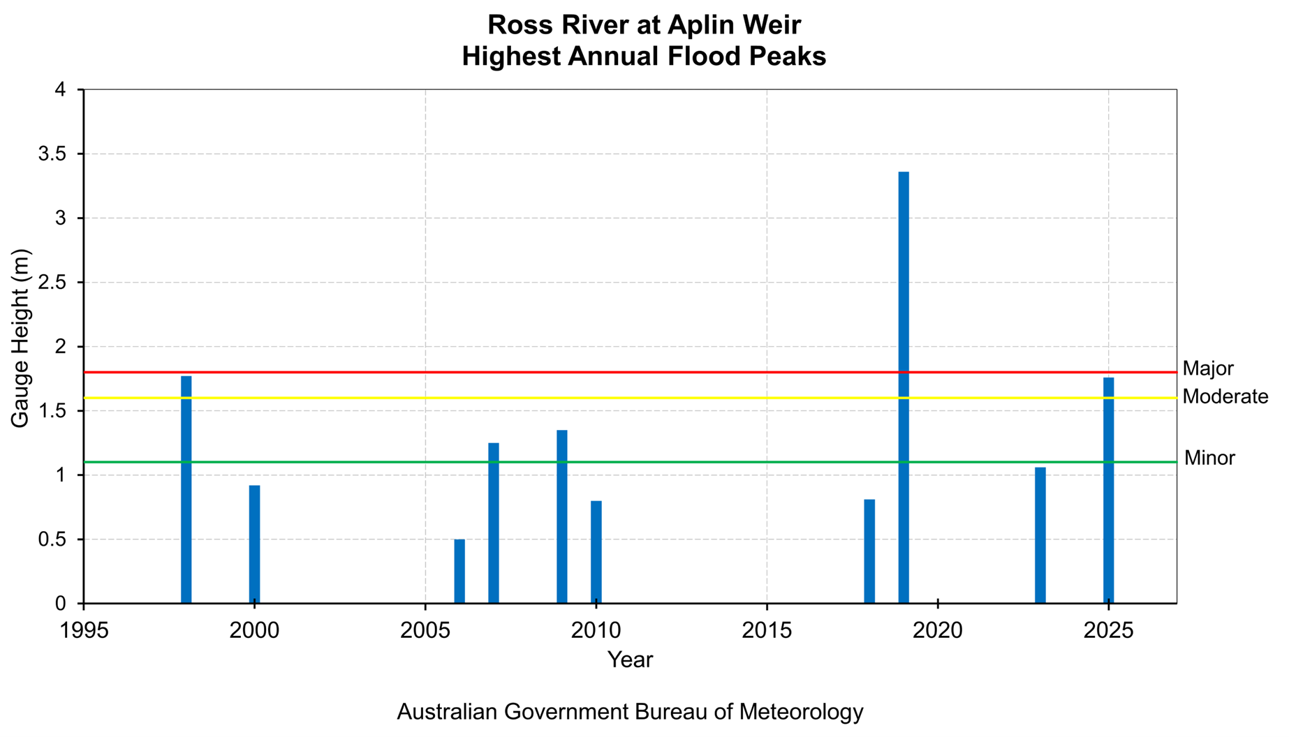
The Ross River catchment only has a short history of flood records. The oldest station in the catchment is located at Mysterton which began recording water levels in the year 2000.
In 2019, an active monsoon trough and slow-moving low pressure system over the northern tropics produced extremely heavy rainfall in tropical Queensland from late January into early February. The major flooding in the Ross, Bohle, and Black Rivers that followed was unprecedented for the catchments.
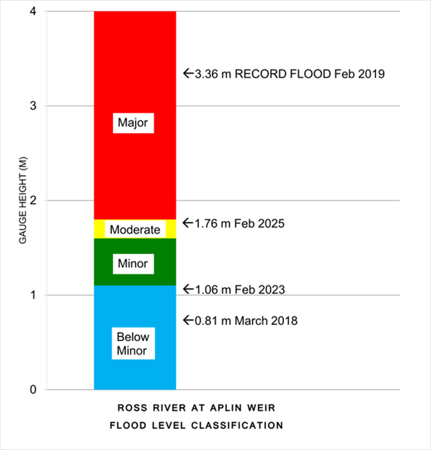
Townsville was significantly impacted, exceeding its previous flood of record by a margin of metres, with infrastructure, businesses and thousands of properties affected. At Aplin Weir (Townsville), the highest flood peak of 3.36 m was recorded at 11:28 pm on 3 February 2019. More recently in February 2025, an active monsoon trough and several tropical lows produced a prolonged period of heavy rainfall over parts of northern Queensland with water levels reaching 1.76 m at Aplin Weir.
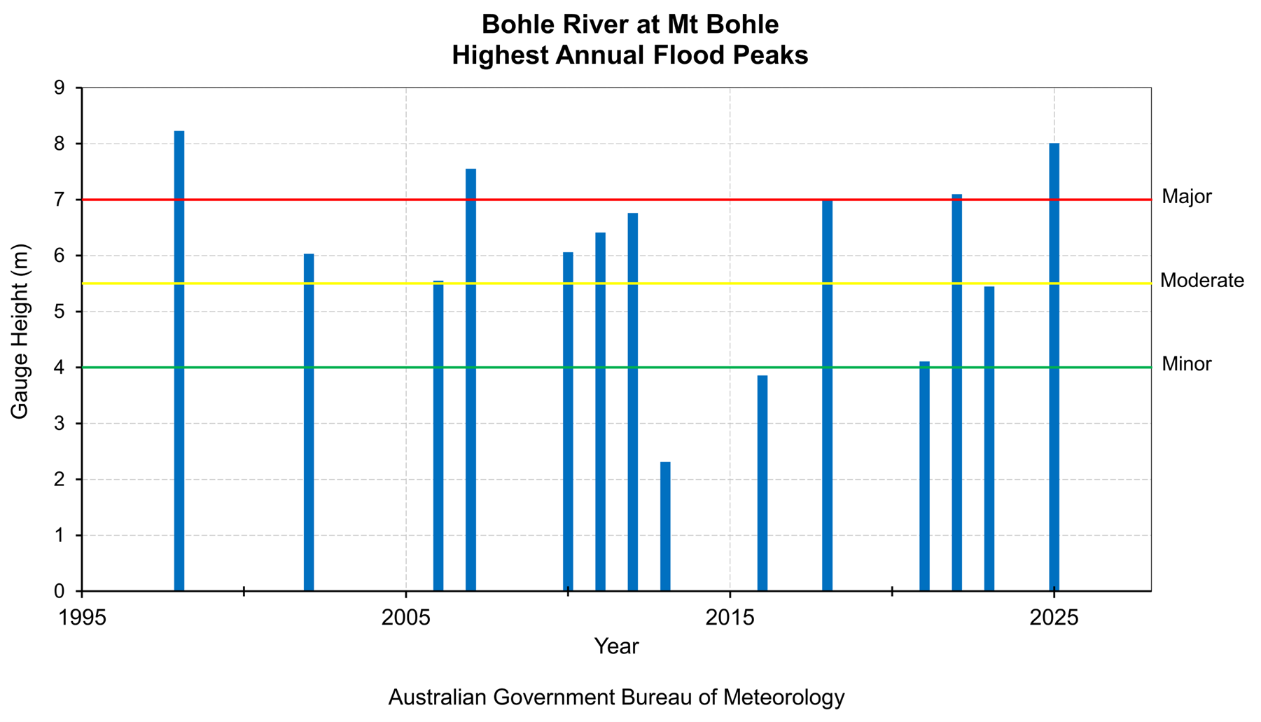
The Bohle River has records since 1986 and has reached major flooding several times, including 1991, 1997, 1998, 2000, 2007, 2019, and 2025. At Mt Bohle, the river level peaked at 8.01 m on 2 February 2025 and the highest peak recorded is 8.23 m in January 1998. No peak was recorded in 2019.
The Black River has records since 1989 and has reached the major flood level in 1991, 1998, and 2018, 2019 and most recently in 2025. The largest flood recorded for the Black River was in January 1998 when flood levels reached 9.38 m at the Black River gauge, causing widespread flooding throughout the area. Significant floods also occurred in 2019 when a peak level of 8.2 m was recorded, and in 2025 when a peak level of 7.16 m was recorded.
| Flood Event | Aplin Weir | Mt Bohle |
| Jan 1998 | 1.77 | 8.23 |
| Feb 2007 | 1.25 | 7.55 |
| Feb 2019 | 3.36 | - |
| Feb 2025 | 1.76 | 8.01 |
All heights are in metres on flood gauges.
Further Information:
- Latest rainfall and river heights
- For information on the flood warning service for the Ross, Bohle and Black Rivers River: Queensland Service Level Specification
- Catchment map: Ross, Tully, Murray, Herbert map
- National Arrangements for Flood Forecasting and Warning