


Climate of Longreach area |
|
|
|
|
Longreach has a sub-tropical continental climate. In general winter days are warm and sunny and nights are cold. During summer days tend to be hot and nights warm. Summer weather is influenced by a semi-permanent trough that lies roughly north-south through the interior of the state. The trough is normally the boundary between relatively moist air to the east and dry air to the west. It is best developed and generates most weather during spring and summer months. The position of the trough fluctuates diurnally due to vertical mixing and from day to day due to interaction with broadscale synoptic influences. The trough often triggers convection with showers and thunderstorms on its eastern side. Longreach has dominant summer rainfall. The average annual rainfall nearly 450mm. 
Average maximum temperatures are 36-37 degrees during summer and 23-26 degrees during winter. Minimum overnight temperatures are 22-23 degrees during the summer months and 7-8 degrees during winter. Strong winds are rare and are normally gusts associated with thunderstorms during late spring or summer. Thunder is reported on average 23 days per year with most reports occuring from late spring through summer to early autumn. Longreach reports fog 1-2 times each year on average and frosts about 8 times each year. Maximum temperatures can reach the low to mid 40's from mid-spring through summer into autumn. Minimum overnight temperatures below freezing are relatively common during winter. The Thomson River and its tributaries flow in a general southerly direction and has several of the larger towns of the region including Longreach and Muttaburra along its banks. Records of large floods in the area extend back as far as the late 19th century, with the most significant episodes of flooding occurring in 1893, 1906, 1949, 1955, 1963, 1974, 1990 and 2000. 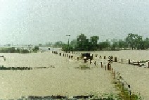
|