


Wednesday, 1 August 2007 - Monthly Climate Summary for Sydney extremes - Product code IDCKGC1xx0
Coldest July in Sydney for 9 years
Summary
- Average temperatures very close to historic averages
- However, average maximum temperature lowest since 1998
- Rainfall below average
- Frosty nights in western suburbs
- Windy along coast, 6 windy days recorded
- Sunny month with above average sunshine hours
Rainfall
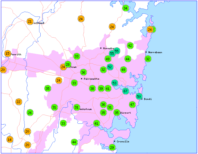
The total July rainfall of 67.2 mm at Sydney Observatory Hill was below the historic July average1 of 97.6 mm. Although the monthly total is only 69% of the average it still falls within the normal range of variability for July totals. Practically the whole month's rainfall occurred on 2 days, the 9th and 10th, when a low pressure system passed over Sydney. Very little rain occurred over the remainder of the month with high pressure systems dominating the Sydney region. There were 8 rain days during the month, below the historic average of 10 rain days. Rainfall distribution over the Sydney area for July was highest in parts of the eastern and northern suburbs and lowest in the western suburbs with well below average totals in the far west. Totals ranged from 67.2 mm at Sydney Observatory Hill to 12.0 mm at Springwood in the lower Blue Mountains. See Sydney rainfall distribution map.
Despite the below average rainfall over Sydney and much of NSW in July, computer models (current as of 1st August 2007) are still predicting moderate cooling of the central and eastern tropical Pacific Ocean in the next month or two, and a moderate chance of a La Ni�a occurring in 2007. Even if La Ni�a thresholds are not met, cooler than average waters in the central to eastern Pacific are usually associated with average to wetter than average seasons over eastern and northern Australia, especially if accompanied by positive SOI values. More information and updates on La Ni�a can be found at the Bureau's ENSO Wrap-up page.
The Warragamba Dam catchment received only light rainfall during July, however, supply levels continued to increase slowly. Monthly totals over the catchment were generally in the 10−20 mm range, significantly below the historic July average of 40−50 mm. Recent rainfall in Sydney's catchments can be found on the Sydney Catchment Authority web site at: http://www.sca.nsw.gov.au/dams/rainfall.html.
Temperatures
The average maximum (daytime) temperature at Observatory Hill was 17.1°C, which is equal to the historic average1. Although temperatures were average, it is still the lowest average maximum for July since 1998 (when 16.2°C). The elevated locations of Springwood (362 metres) and Terrey Hills (199 metres) recorded slightly cooler daytime temperatures.
Night-time temperatures were close to average along the coast but below average in the far west. The average minimum at Sydney (Observatory Hill) of 8.5°C was 0.1°C above the historic1 July average. However, minimum temperatures were more than 5°C lower in far western suburbs, averaging 3.2°C at Richmond. Extended periods of frost were recorded in low-lying parts of the western suburbs, especially from 12th to 19th July. Liverpool recorded 13 frosts during the month compared to an average of 7 frosts for July.
The highest temperature at Sydney (Observatory Hill) during July was 23.4°C on the 26th while the lowest temperature was 3.7°C on the 17th. This is the lowest temperature recorded at the Observatory Hill site in 21 years (since 3.1°C in July 1986). Corresponding extremes in the Sydney area ranged from 23.8°C at Sydney Olympic Park and Parramatta on the 3rd to −3.5°C at Badgerys Creek on the 17th.
Although coastal Sydney recorded close to average temperatures in July, several factors have made it seem colder, including a series of mild Julys in recent years. Since 1999 every July has recorded an average maximum temperature between about half and 2°C above the historic average. This period also includes Sydney's warmest July on record (2005) as well as its 3rd and 4th warmest Julys (2002 and 2000). Other factors include a higher than usual number of windy days (see wind section below).
For the winter season so far (1 June to 31 July), Sydney has had its coldest start to winter since 1989. The average maximum temperature for the 2 month period is 16.9°C, the lowest since 1989 when 16.5°C was recorded. The historic average maximum for the 2 month period is 17.4°C.
Some sites had their lowest July temperature on record.
Wind
Sydney experienced quite windy conditions in July, especially along the coast, with 6 windy days recorded (average speed 40−62 km/hr), compared with an average of 4 windy days. The highest wind gust in the Sydney area was 91 km/hr at Sydney Airport on the 5th. The prevailing direction during the month was NW to SW with about 77% of all winds within this quadrant. Normally Sydney would expect less than 60% of winds from this direction. The prevailing westerlies contributed toward the dry conditions experienced in the Sydney area during July.
Other phenomena
Generally sunny conditions prevailed during July with sunshine averaging 7.2 hours per day compared to the historic average for July is 6.6 hours per day. There were two thunderstorms during the month (historic average 1storm), one producing small hail on the 9th.
Further information
Mike De Salis
NSW Climate Services Centre
Bureau of Meteorology
Phone (02) 9296 1555
Email mikede@bom.gov.au
Extremes for the Sydney area
| Hottest day Highest temperature |
23.8°C at Parramatta and Sydney Olympic Park on the 3rd |
|---|---|
| Warmest days on average Highest mean daily maximum temperature |
17.3°C at Sydney Olympic Park |
| Coolest days on average Lowest mean daily maximum temperature |
15.4°C at Terrey Hills |
| Coldest day Lowest daily maximum temperature |
11.8°C at Terrey Hills on the 8th |
| Coldest night Lowest temperature |
−3.5°C at Badgerys Creek on the 17th |
| Coolest nights on average Lowest mean daily minimum temperature |
2.9°C at Campbelltown (Mount Annan) |
| Warmest nights on average Highest mean daily minimum temperature |
8.5°C at Sydney (Observatory Hill) |
| Warmest night Highest daily minimum temperature |
13.9°C at Sydney (Observatory Hill) on the 4th |
| Wettest overall Highest total rainfall |
67.2 mm at Sydney (Observatory Hill) |
| Driest overall Lowest total rainfall | 12.0 mm at Springwood |
| Wettest day Highest daily rainfall |
43.8 mm at Riverview on the 9th |
| Highest wind gust |
91 km/h at Sydney Airport on the 5th |
Jump to: Extremes Records Summaries Notes the top
Jump to: Extremes Records Summaries Notes the top
Summaries for the Sydney area
| Summary statistics for July 2007 | ||||||||||||
|---|---|---|---|---|---|---|---|---|---|---|---|---|
| Maximum temperatures for July (°C) |
Minimum temperatures for July (°C) |
Rainfall for July (millimetres) |
||||||||||
| Mean for July 2007 |
Diff from normal |
Highest for July 2007 |
Mean for July 2007 |
Diff from normal |
Lowest for July 2007 |
Total for July 2007 |
Normal for July |
Rank of July 2007 |
Fraction of July normal |
|||
| Sydney (Observatory Hill) | 17.1 | 0.0 | 23.4 | 26th | 8.5 | +0.1 | 3.7 | 17th | 67.2 | 97.6 | normal | 69% |
| Parramatta | 17.1 | −0.2 | 23.8 | 3rd | 6.2 | 0.0 | 0.0 | 17th | 35.8 | 45.9 | normal | 79% |
| Richmond | 17.0 | −0.3 | 22.7 | 3rd | 3.2 | −0.3 | −3.4 | 17th | 20.8 | 35.9 | low | 58% |
|
Liverpool |
17.1 |
−0.2 |
23.4 |
26th |
3.4 |
−1.3 |
−2.6 |
17th |
31.2 |
40.1 |
normal |
78% |
| Springwood* | 15.6 | 21.6 | 26th | 4.9 | −2.6 | 17th | 12.0 | 58.0 | low | 21% | ||
| Terrey Hills* | 15.4 | 21.6 | 3rd | 6.8 | 0.2 | 17th | 42.0 | |||||
*new stations, no historic average temperatures available and no historic average rainfall available for Terrey Hills.
| Additional climate data for Sydney (Observatory Hill) for July 2007 | ||
|---|---|---|
|
July 2007 |
Normal for July |
|
| Number of rain days |
8 |
10 |
| Average sunshine hours per day* |
7.2 |
6.6 |
| Average humidity at 3pm (%) |
47 |
52 |
| Number of thunderstorms |
2 |
1 |
| Number of windy days* |
6 |
4 |
* recorded at Sydney Airport
Jump to: Extremes Records Summaries Notes the top
Notes
This statement has been prepared based on information available at noon on Wednesday 1 August 2007. The data has been quality controlled, but it is possible that results will change as new information becomes available.
1Averages: historic average temperatures for Observatory Hill and Richmond are based on the period 1961 to 1990 which is a convention of the World Meteorological Organisation. Average temperatures for Parramatta are based on all available data, 1968 - 2006 and Liverpool 1962 - 2006. Rainfall averages and extremes for Observatory Hill are based on all years of record 1859 - 2006.
Normals are long-term means based on observations from
all available years of record, which vary widely from site to site.
They are not shown for sites with less than 10 years of record, as they cannot then be calculated reliably.
The median
is sometimes more representative than the
mean
of "normal" rain.
The Rank indicates how rainfall this time compares with the climate record for the site,
based on the
decile ranking
(very low rainfall is in decile 1, low in decile 2 or 3,
normal in decile 4 to 7, high in decile 8 or 9
and very high is in decile 10).
The Fraction of normal shows how much rain has fallen this time as a
percentage of the long-term mean.