


Sydney: Region description
- The region is located on the New South Wales coast, and includes Sydney - Australia's largest and most populus city.
- The Hawkesbury-Nepean River is the most significant river system in the region, and includes the Coxs River which flows into Warragamba Reservoir - the region's largest storage.
- Surface water is the main water source, mainly for urban and agricultural uses, which are supplied via an extensive storage network.

For further information about the region scroll down this page or click on the links below:
Geographic information
")
General description
Area: 30,800 km²
Population: 5.71 million (Australian Bureau of Statistics 2021 - Greater Sydney
Area*)
*Also includes the Illawarra region and Southern
Highlands & Shoalhaven region

Figure R1 Contextual map of the
Sydney region
- The Sydney region is defined by most of the Hawkesbury-Nepean River catchment, as well as the Shoalhaven River, Sydney Coast-Georges River, and Wollongong Coast catchments.
- Home to roughly 71% of New South Wales' total population, most of whom reside within the Sydney metropolitan area, it is the most populus region in the country.
- The Hawkesbury-Nepean River catchment is the most significant river system in the region, providing water to large parts of conservation and natural environments.
Land use

Figure R2 Land use in the Sydney
region
- Conservation and natural environments is the most common land use, comprising 55% of the region's area, while 25% of the region is used for grazing.
- Urban centres make up 8% of the region's total area, which includes most of the region's population.
Significant aquatic ecosystems

Figure R3 Significant wetlands and
cultural places in the Sydney region
- The Towra Point Nature Reserve is an estuarine Ramsar wetland which lies on the northern side of Kurnell Peninsula, forming the southern and eastern shores of Botany Bay, and is approximately 16 km south of the Sydney city centre in New South Wales.
- There are also 23 Nationally Important Wetlands listed in the Directory of Important Wetlands in Australia within the region.
- Numerous surface water sources are ecologically important, including endangered ecological communities found in the Maroota Sands Swamp Forest and Sydney Freshwater Wetlands.
- According to the Water Sharing Plan for Greater Metropolitan Region Unregulated River Water Sources 2023, there are 26 river management zones within the region assessed as having high instream values.
- The Water Sharing Plan for Greater Metropolitan Region Groundwater Sources 2023 have identified 19 high priority groundwater dependent ecosystems within the region, such as the Botany Wetlands, Lake Bathurst, and Towra Point Estuarine Wetlands, as well as 21 high priority karst environments, such as those found in the major cave systems of Bungonia, Jenolan, and Wombeyan.
Significant Aboriginal cultural places and practices
- Kangaroo River, recognised as an area of cultural significance, as well as a source of food for Aboriginal communities, is an important area for the Norwa and Illawarra local Aboriginal land councils.
Water resources
- Surface water is the main water source in the region, mainly for urban and agricultural uses, with flows from several major rivers highly regulated by numerous dams and weirs.
- The region's surface water storage capacity per capita, much like the rest of Australia, is considerably above the world's standard due to the irregular interannual rainfall-runoff patterns.
- Other water sources include groundwater, desalinated water from the Kurnell desalination plant to the Sydey metropolitan area, recycled water supplied by Sydney Water Corporation and several local councils, and inter-basin transfers to the region from the Fish River Water Supply Scheme.
Surface water
Rivers

Figure R4 Streamflow gauging stations along the main
rivers within the Sydney region
- There are three main river systems within the Sydney region: the Hawkesbury-Nepean River, the Shoalhaven River, and the Illawarra and metropolitan Sydney catchments.
- The Hawkesbury-Nepean and Shoalhaven River systems are the two primary river systems within the region.
- Two gauging stations (Shoalhaven River at Warri (215002) and Coxs River at Island Hill (212045)) are used to represent the seasonal flow patterns of rivers in the region (shown in Figure R4). Streamflows along these rivers upstream of the gauging stations are unregulated and not influenced by diversions for consumptive use.
- The Coxs River flows into Warragamba Reservoir - the region's largest storage.
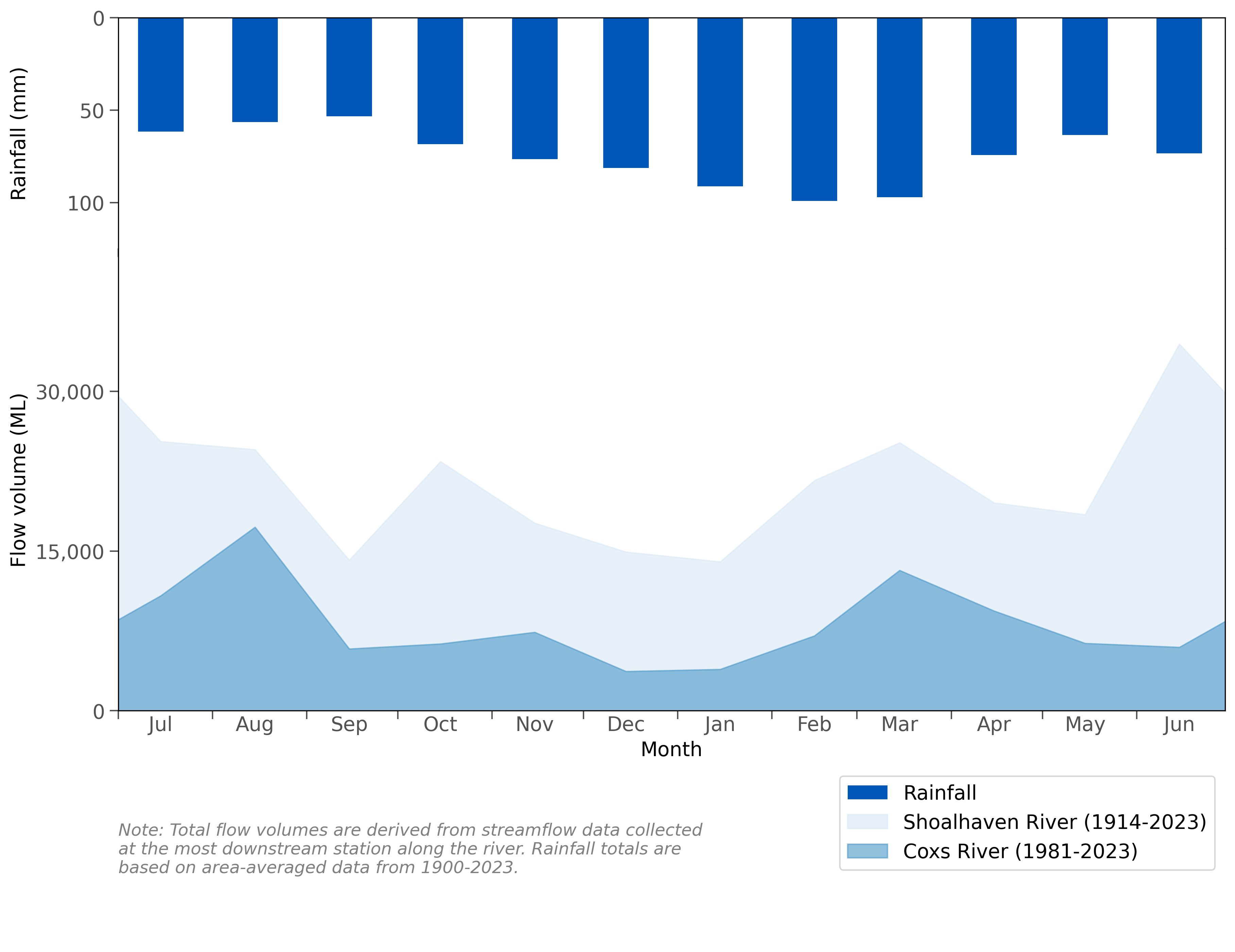
Figure R5 Mean monthly flows along the Coxs River (part of the
Hawkesbury–Nepean River system) and Shoalhaven River and mean monthly rainfall for the Sydney
region
- Rainfall is generaly uniform throughout the year, but higher totals are more common during summer and autumn (December to May).
- Streamflows in the region's rivers typically have perennial flows, reflecting the relatively uniform distribution of rainfall throughout the year.
- More information of the region's rainfall and streamflows can be found in the Climate and water section of the account.
Storages

Figure R6 Major storages in the
Sydney region; capacity of each storage is also shown
- An extensive storage and weir network is used for capturing streamflows and securing water in the Sydney region.
- Warragamba, the region's largest storage, constitutes for 70% of the region's total storage capacity.
- Water from the Shoalhaven catchment can be diverted to the Hawkesbury-Nepean catchment through the Lake Yarrunga (Tallowa), Bendella Pondage, and Fitzroy Falls storages.
Intervalley transfers
- The Fish River Water Supply Scheme delivers water from outside the region (Oberon Dam and Duckmaloi Weir) to major customers within the region, including Lithgow City Council, Energy Australia, and WaterNSW.
- There are also intervalley water transfers within the region between the Shoalhaven, Hawkesbury–Nepean, and Sydney coastal catchments. As these transfers occur within the region, they are not quantified individually in this account, but form part of the overall surface water store balance.
Desalinated water
- The Sydney Desalination Plant was constructed from 2007 to 2010 to provide relief to Sydney's water supply during the Millennium Drought. At the peak of the Millennium Drought in 2006, water storage levels in the region dropped to 33.8%, triggering the need for a desalination plant to secure water supply needs for the region moving forward.
- Following the completion of its construction in 2010, the plant remained in operation until 2012, when the NSW Minister for Finance and Services, Greg Pearce, directed the Sydney Desalination Plant to cease operation after the storage levels of the region reached 90% capacity.
- Production of the Sydney Desalination Plant was directed to recommence when dam storage levels dropped to 60% and would remain in production until dam storage levels reached 70%.
- In 2019, the desalination plant recommenced operation, following storages falling to their lowest level since the Millennium Drought, to bolster drinking water supplies across the region. Since then, it has remained in operation to ensure the continued delivery of safe and clean drinking water to the region, particularly during the 2020 NSW bushfires and subsequent heavy rain events, where large amounts of bushfire ash, debris, and sediment caused water storage quality issues that were further exacerbated by flooding events in 2022.
- The Sydney Desalination Plant is the region's only major non-rainfall dependent source of drinking water and operates continuously to produce up to 15 per cent of the region's drinking water needs.
- At full operation, the desalination plant can supply up to 250 ML of drinking water per day, equating to 91.25 GL per year, to about 1.5 million people across homes and businesses.
- The Sydney Desalination Plant was originally constructed with expansion in mind. If/when the construction of the expansion plans take place, at full operation, it would have the capabilities to produce up to 500 ML of drinking water per day - double its current capacity.
Water systems
Urban water system
- Sydney Water is the major water utility of the region, providing 1,500 ML/day of potable water to about 5.3 million people across Sydney, the Blue Mountains, and Illawarra region.
- Urban water is supplied from 11 major dams through 13 water delivery systems, including 251 reservoirs and 153 drinking water pumping stations, with roughly 22,804 km of water pipelines installed to transport and divert water between systems to meet demands. Approximately, 80% of this water is sourced from Warragamba Dam (Lake Burragorang). The rest comes from a mix of other dams, the Hawkesbury-Nepean River, and the Sydney Desalination Plant (see above).
- Other organisations that supply urban water in the region are Shoalhaven Water, Goulburn Mulwaree Council, Lithgow City Council and Wingecarribee Shire Council.
Wastewater and recycled water system
- Sydney Water operates the main wastewater network in the region, which treats wastewater and recycled water.
- The wastewater systems consist of 30 wastewater treatment plants (which treat over 1,300 ML of wastewater per day) and 695 wastewater pumping stations over 27,000 km of wastewater pipes. Most treated wastewater is discharged to waterways estuaries, or the ocean.
- The recycled water systems consists of 14 water recycling plants, 12 recycled water pumping stations, and 9 recycled water reservoirs over 808 km recycled water mains. Recycled water is distributed for urban, agricultural, and other uses.
- Four wastewater treatment plants within the region are operated by the Shoalhaven City Council, while the Wingecarribee Shire Council, Lithgow City Council, and Goulburn Mulwaree Council also operate treatment plants within the region. Most treated wastewater from these treatment plants is discharged into waterways, with small quantities of recycled water used for plant operations, on-site use, and agriculture.
Water management
")
Surface water and groundwater management
Water legislation
- Water management in New South Wales is governed primarily by the Water Management Act 2000, though some provisions of the Water Act 1912 remain in place.
- There are three other legislative instruments related to water management in the Sydney region: the Sydney Water Catchment Management Act 1998 and Sydney Water Act 1994, which govern the roles and responsibilities of WaterNSW and Sydney Water, respectively; and the Energy and Utilities Administration Act 1987, which governs water savings initiatives.
Water management plans
- The NSW Department of Climate Change, Energy, the Environment and Water is responsible for managing surface water and groundwater resources in the State through the preparation of water sharing plans. Water management plans are current over a 10-year period, after which the water sharing plans are reviewed and revised or reinstated as appropriate.
Surface water
- Surface water resources in the region are managed under the Water Sharing Plan for the Greater Metropolitan Region Unregulated River Water Sources 2023, which commenced on 01 July 2023, replacing the previous plan, the Water Sharing Plan for the Greater Metropolitan Region Unregulated River Water Sources 2011.
- Under the Water Sharing Plan for the Greater Metropolitan Region Unregulated River Water Sources 2023, there are four Water Management Areas, including the Hawkesbury Nepean Water Management Area, Southern Sydney Water Management Area, Southern Water Management Area, and the Sydney Harbour Water Management Area.
- These Water Management Areas are split into 26 management zones and 65 water sources, all of which are listed in the Water Sharing Plan for the Greater Metropolitan Region Unregulated River Water Sources 2023.

Figure R7 Water source areas within
the Sydney region
Groundwater
- Groundwater resources in the region are managed under the Water Sharing Plan for the Greater Metropolitan Region Groundwater Sources 2023, which commenced on 01 July 2023, replacing the previous plan, the Water Sharing Plan for the Greater Metropolitan Region Groundwater Sources 2011
- Groundwater is a minor water source in the region and is mainly used for irrigation or industrial purposes.
- Under the Water Sharing Plan for the Greater Metropolitan Region Groundwater Sources 2023, there are four Water Management Areas, including the Hawkesbury Nepean Water Management Area, Southern Sydney Water Management Area, Southern Water Management Area, and the Sydney Harbour Water Management Area.
- These Water Management Areas are split into 10 Groundwater Sources within the region which are grouped into three categories: fractured rock, porous rock, and coastal sands, tertiary sands and alluvial.

Figure R8 Groundwater management units within the
Sydney region
Environmental water management
- The Water Management Act 2000 makes provision for the environmental health of the region's water resources through two mechanisms: planned environmental water and adaptive environmental water.
- The regulating authority overseeing environmental flow management in the Sydney region is the NSW Department of Climate Change, Energy, the Environment and Water.
Planned environmental water
- Planned environmental water is water that is committed by management plans for fundamental ecosystem health or other specified environmental purposes, either generally or at specific times or in specified circumstances, and that cannot to the extent committed by taken or used for any other purpose.
- For unregulated rivers, these rules may include requiring visible flows or specified flow levels before extraction of water, and/or setting daily limits on extraction.
- Rules for groundwater can include reserving storage components or a proportion of the natural recharge for aquifers, and/or setting distance limits between new bores and groundwater dependent ecosystems.
Adaptive environmental water
- Adaptive environmental water allows licenced water to be managed in a way that balances ecological needs with human demands. Unlike standard water licences, which typically specify fixed quantities of water for various uses, adaptive environmental water licences are designed to be flexible and responsive to changing environmental conditions.
- Under the Water Management Act 2000, there are three types of adaptive environmental water licences prescribed for various regulatory mechanisms. These include:
- Adaptive environmental water through dedication of existing water entitlements
- Adaptive environmental water through system improvements
- Adaptive environmental water conditions after surrender of licences
Cultural water management
- The Aboriginal Water Initiative Program, which operated from 2012 to 2017, aimed to improve Aboriginal involvement and representation in water planning and management within NSW.
- Throughout the programme, the NSW Office of Water monitored the success of water sharing plans in meeting stautory requirements for Aboriginal specific performance indicators noted under the Water Management Act 2000.
- These requirements included providing water for Native Title Rights, recognising spiritual, social, customary, and economic values of water to Aboriginal people, and establishing flow rules to protect Aboriginal cultural values dependent on water.
Organisations responsible for water management

Figure R9 Operational boundaries of
the Sydney Water Corporation and WaterNSW within the Sydney region
- WaterNSW is the bulk water supplier and diverts water to the major utility, Sydney Water Corporation.
- WaterNSW also supplies water to other local utilities (Goulburn Mulwaree Council, Shoalhaven City Council and Wingecarribee Shire Council) and retail customers in the region.
- Several other organisations also divert surface water from water sources based on their water access entitlements.
| Organisation | Responsibility | Storages within the region |
| EnergyAustralia |
|
|
| Goulburn Mulwaree Council |
|
|
| Hawkesbury–Nepean Catchment Management Authority |
|
n/a |
| Lithgow City Council |
|
|
| Local Land Services |
|
n/a |
| NSW Department of Environment and Heritage |
|
n/a |
| NSW Department of Planning, Housing and Infrustructure |
|
n/a |
| Origin Energy |
|
n/a |
| Queanbeyan–Palerang Regional Council |
|
n/a |
| Shoalhaven City Council |
|
|
| Sydney Water Corporation |
|
n/a |
| WaterNSW |
|
|
| Wingecarribee Shire Council |
|
|
Water rights
")
Operating rules and constraints
- The NSW Department of Climate Change, Energy, the Environment and Water manages the entitlements in the Sydney region in accordance with the Water Management Act 2000. Water access licences are registered with the Lands Title Office (NSW), while the NSW Department of Climate Change, Energy, the Environment and Water manages the day-to-day operation of the entitlements, including the maintenance of allocation accounts.
- Water access licences issued to major water utilities provide further guidance to the rules established in the Water Sharing Plan for the Greater Metropolitan Region Unregulated River Water Sources 2023.
- Water restrictions in Sydney Water's management area are authorised by the Minister administering the Sydney Water Act 1994. Water restrictions in other areas are determined and managed by the local urban water utilities. For more information, refer to the Bureau of Meteorology's Water Restrictions website.
- Water allocation volumes for the Fish River Water Supply Scheme are based on water supply agreements between WaterNSW and its customers; allocations are restricted according to storage level when Oberon Reservoir drops below 50%, and entitlement holders are allowed to carryover their unused allocation up to a maximum of 20% of the maximum annual quantity.
- Origin Energy holds an entitlement to service interchanges between Lake Yarrunga and Fitzroy Falls reservoir and between Bendeela Pondage and Lake Yarrunga at any time for hydro-power generation, with increases to interchange volume subject to conditions related to high power demand, power system failure, and flow conditions in Yarrunga Creek.
Water entitlements and other statutory water rights
- Water access licences entitle holders to specified shares of available water (a share component), and to take water under specified conditions (an extraction component). These entitlements are separate from land ownership. Licences can be granted as continuing water access licences, or as specific purpose water access licences which must be cancelled when the purpose for which the licence was issued ceases.
- The share component of a water access licence is expressed as a unit share of the water available for continuing water access licences, or in megalitres for specific purpose water access licences. The actual quantity of water available to be extracted in any year depends on an available water determination.
- The extraction component specifies the part of the water source where water may be taken; it may also specify limits on times, rates or circumstances of extraction.
- Three basic landholder rights to water also exist: domestic and stock rights, native title rights, and harvestable rights. For groundwater, extraction other than under domestic and stock rights requires a licence issued by the NSW Department of Climate Change, Energy, the Environment and Water.
Water allocations
- The NSW Department of Climate Change, Energy, the Environment and Water manages the available water determination process over a 1 July–30 June water year for both surface water and groundwater. The amount of water available for extraction and associated rules (in particular, carryover rules) are outlined in the two water sharing plans for the region.
- The key elements of announcements for available water determinations are the water source, licence category, announcement type, date or period to which the announcement applies, and the volume announced per share.
- Priorities for water sharing depend on water access licence/entitlement categories; the environment has first priority, followed by basic rights (domestic and stock rights, harvestable rights and native title rights) and then all other licensed rights.
- Entitlement holders are able to draw their maximum entitlement volume unless, due to a limited supply of water, authorities announce an 'as needs' basis.
- No allocations are determined for basic water rights; however, in times of limited supply, restrictions on take for basic rights may be announced.
Trades and water rights transfers
- Interstate transfer of access licences or interstate assignment of water allocations are prohibited for both surface water and groundwater.
- Water trading rules are defined in both water sharing plans for the region; however, the required mechanisms for inter-valley trading do not yet exist.
- Trade between water sources is not permitted.