


Murray–Darling Basin: Geographic information
- The Murray–Darling Basin is one of the more productive agricultural regions in Australia containing 70% of Australia's irrigated land area.
- The region also contains over 30,000 wetlands, including 16 Ramsar-listed wetlands.
- Surface water is the region's main water resource, primarily used for irrigated agriculture.

For further information about the region scroll down this page or click on the links below:
Geographic information
")
General description
Area: 1,055,600 km²
Population: 2,252,000 (Australian Bureau of Statistics [ABS] 2016)
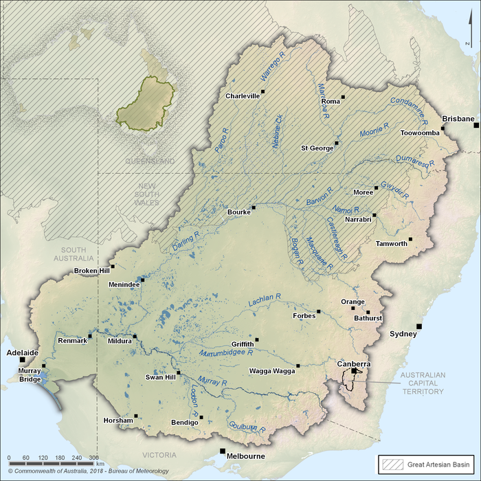
Figure R1 Contextual map of the Murray–Darling Basin region
- The Murray–Darling Basin region is defined by the catchment areas of the Murray and Darling rivers and their many tributaries. It contains 40,000 km of major rivers and approximately 440,000 km of rivers in total.
- The region makes up 14% of mainland Australia and covers 75% of New South Wales, more than 50% of Victoria, sections of Queensland and South Australia, and all of the Australian Capital Territory
- The majority of the Murray–Darling Basin region is made up of extensive plains and low undulating areas; the highland areas of the Great Dividing Range are located along the eastern and southern boundary of the region.
- About 55% of Australia's water use occurs in the region, mostly from surface water for agricultural purposes.
Land use
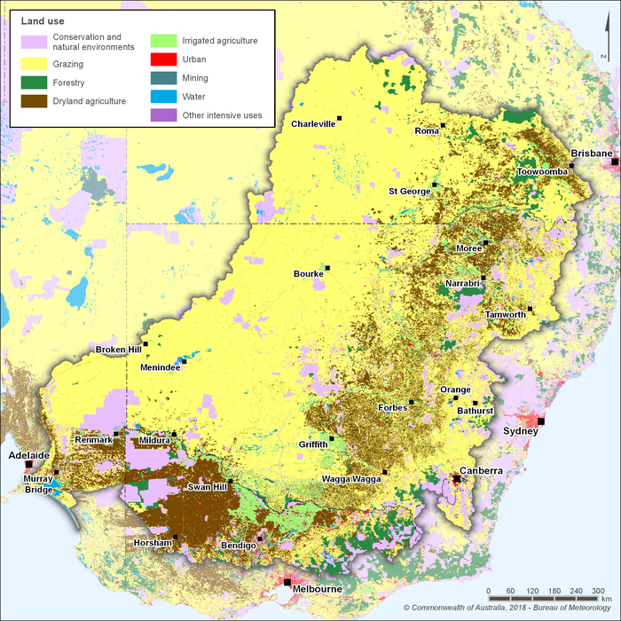
Figure R2 Land use in the Murray–Darling Basin region
- The Murray–Darling Basin region is one of the more productive agricultural regions in Australia containing 40% of all Australian farms by number (Murray–Darling Basin Authority [MDBA] 2016).
- 63% of the region is for grazing, which is the dominant land use activity in the region.
- Irrigated agriculture makes up around 3% of the region's total area, but is the major water user in the region.

Figure R3 Irrigated areas within the Murray–Darling Basin region
- The Murray–Darling Basin region contains 70% of Australia's irrigated land area (MDBA 2016). The major irrigation areas in the region include Murrumbidgee Irrigation, Coleambally Irrigation, Murray Irrigation and Goulburn–Murray Water.
Significant aquatic ecosystems
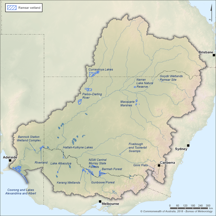
Figure R4 Ramsar wetlands in the Murray–Darling Basin region
- The Murray–Darling Basin region contains over 30,000 wetlands, including 16 Ramsar listed wetlands.
- The region also contains over 100 wetlands of national importance, as listed in the Directory of Important Wetlands in Australia. Many of these sites are significant to Aboriginal and other local communities.
- The iconic River Murray sites are a collection of important locations along the River Murray, selected for their high ecological value and cultural significance. Given the value of these icon sites, The Living Murray program was established to improve the environmental health of the river system.
Significant Indigenous cultural places and practices
- The Murray–Darling river system has been, and continues to be, of high importance to Aboriginal people. Aboriginal people view themselves as an integral part of the land and river systems and feel a strong responsibility for the health of rivers and wetlands.
- Today there are almost 50 Aboriginal nations whose traditional lands are within the Murray–Darling Basin (MDBA 2016).
- There are at least 10,000 known Aboriginal sites in the Murray–Darling Basin, indicating the deep physical, economic, and spiritual dependence of Aboriginal people on its rivers, creeks, lakes, and wetlands.
Water resources
")
- The water resources in the Murray–Darling Basin region are highly developed.
- On average, more than 40% of the total surface water runoff in the region is diverted for consumptive or environmental management purposes.
- Approximately 1.8 million ML of the region's groundwater resources are extracted each year from a small number of large aquifers, mainly for agricultural use.
- The Murray–Darling Basin Authority's Basin Plan has now established sustainable diversion limits (SDLs) for both surface water and groundwater use within the Murray–Darling Basin region.
Surface water
Storages
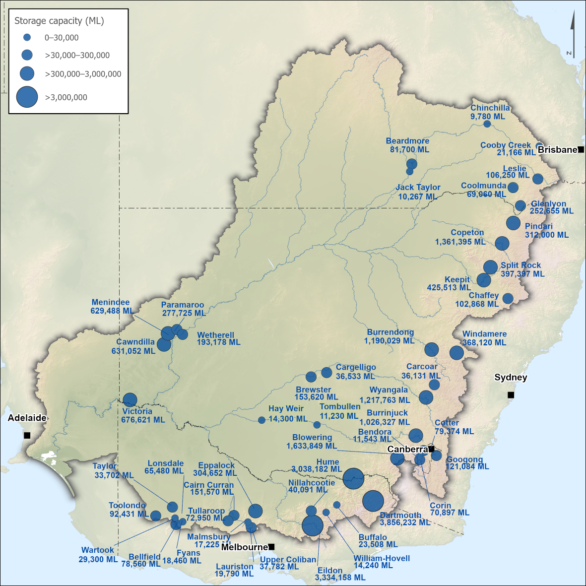
Figure R5 Major storages in the Murray–Darling Basin region; capacity of each storage is also shown
- The northern part of the Murray–Darling Basin region consists mostly of unregulated systems, although major storages are located along some of the rivers including Border, Gwydir, Namoi and Macquarie.
- The southern part of the region is mostly a regulated system with major storages in many of the rivers. The storages in the three major southern rivers—the Murrumbidgee, Murray, and Goulburn—are used to provide regulated flows downstream as far as the lower lakes in South Australia.
- Further information on the water storages in the region, including current levels and volumes, is available from the Bureau of Meteorology's Water storage website.
Rivers
- Many of the rivers and streams in the northern part of the region are ephemeral and flow for a short period following rainfall. Generally, water users in much of this area rely on collecting water during floods and storing it on-farm for later use.
- Most of the rivers in the southern part of the region are regulated; flows in these rivers are influenced by dam operations and diversions for consumptive use.
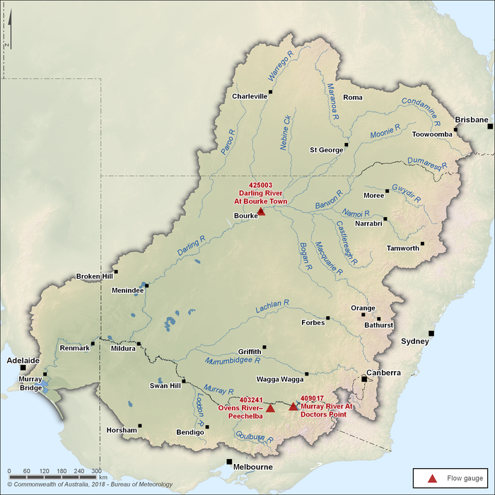
Figure R6 Key flow gauging station locations along the main rivers within the Murray–Darling Basin region
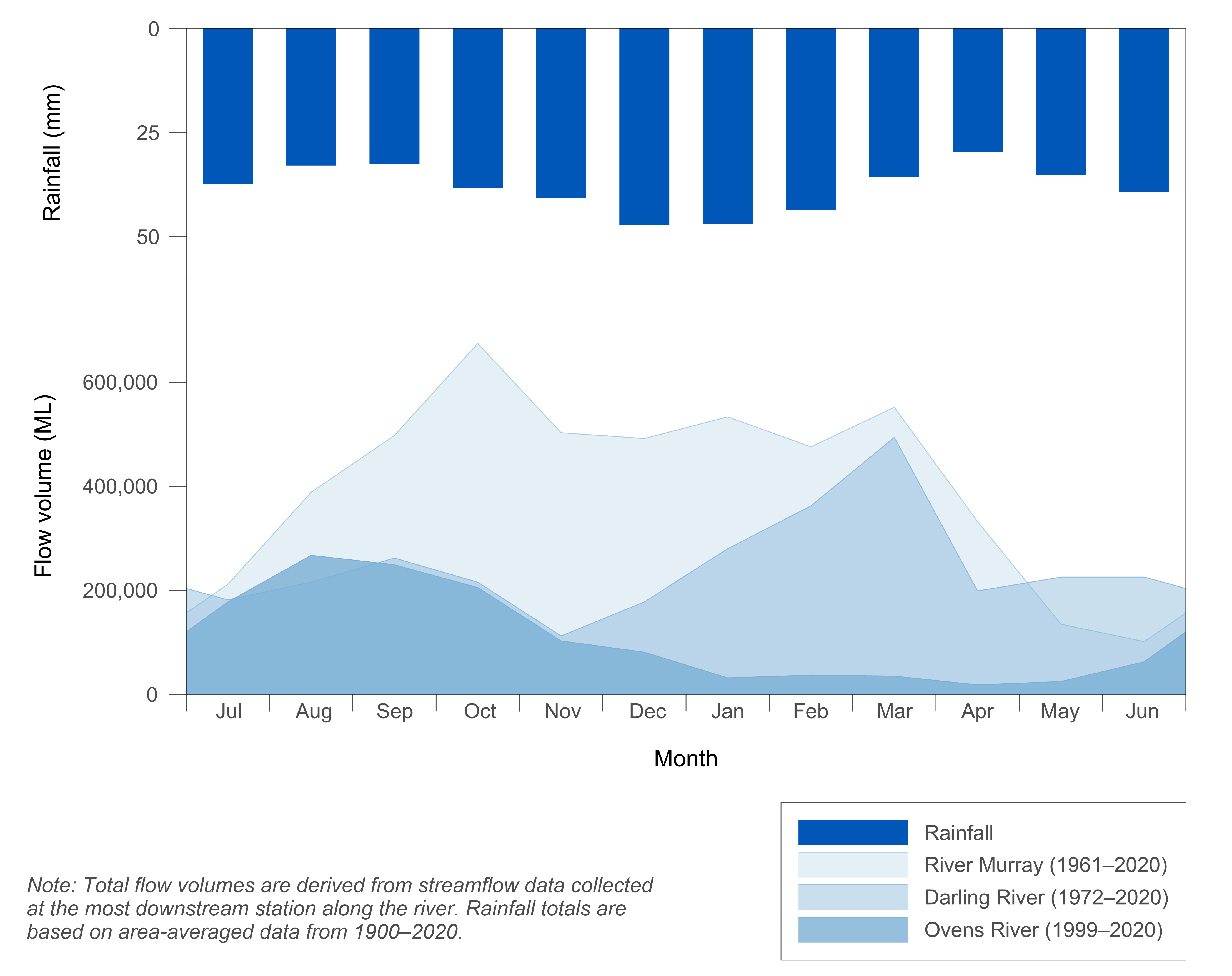
Figure R7 Mean monthly flows in the Murray, Darling and Ovens rivers and mean monthly rainfall for the Murray–Darling Basin region
- Flow in the River Murray is primarily influenced by the status of regulation.
- Flow in the Darling River reflects the rainfall pattern for the northern part of the region, with higher streamflows in the late summer–early autumn months (February–March) following the higher summer rainfall period and a second peak in the late winter–early spring months (August–October) following the winter rainfall.
- In the Ovens River, a largely unregulated major river within the southern part of the region, the seasonal flow characteristics reflect the local rainfall pattern. Higher rainfall and streamflow usually occurs during the winter–spring months (June–November); less rainfall and streamflow occurs in summer and autumn.
- Further information on other gauging stations across the Murray–Darling Basin region is available from the Bureau of Meteorology's Water Data Online website.
Water transfers
- In a number of locations, water is transferred into or out of the Murray–Darling Basin region, as well as from one catchment to another within the Murray–Darling Basin region.
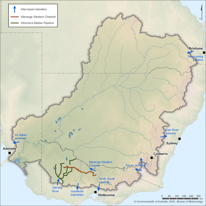
Figure R8 Water transfers into, out of and between catchments within the Murray–Darling Basin region
- The primary water transfer into the Murray–Darling Basin region is via the Snowy Mountains Hydro-Electric Scheme that transfers water to the Murrumbidgee and Murray rivers.
- Other transfers into the region are from the Glenelg catchment to the Wimmera system and the Cressbrook Reservoir to Toowoomba and surrounds.
- Transfers out of the Murray–Darling Basin region include water from the South Australian River Murray to supply metropolitan Adelaide and country towns; the Fish River Water Supply Scheme within the Macquarie River system to the Blue Mountains area in the Sydney region; and the Goulburn River system via the North–South Pipeline for distribution to Melbourne.
- There are also channels and pipelines in rivers within the southern part of the region that allow water to be moved and traded from one catchment to another. For example, the Waranga Western Channel delivers water from the Goulburn River to the Campaspe, Loddon, and Wimmera–Avoca catchments.
Groundwater
- The groundwater systems of the Murray–Darling Basin region can be categorised into four distinct hydrogeological types: the aquifers in sedimentary deposits of the Murray Basin and the Great Artesian Basin (GAB) within the low topographic landscapes; the shallow aquifers of the Darling River Basin overlying the GAB; valley-fill alluvium in the highlands bordering the region; and the local fractured rock aquifers of the Great Dividing Range and other areas.
- The different groundwater systems behave mostly independently of each other, with only relatively small volumes of groundwater directly flowing from one system to another.
- A substantial volume of groundwater enters the rivers in the upper and middle catchments as base flow and then re-enters the groundwater systems further down through seepage from streambeds (Murray–Darling Basin Commission 1998).
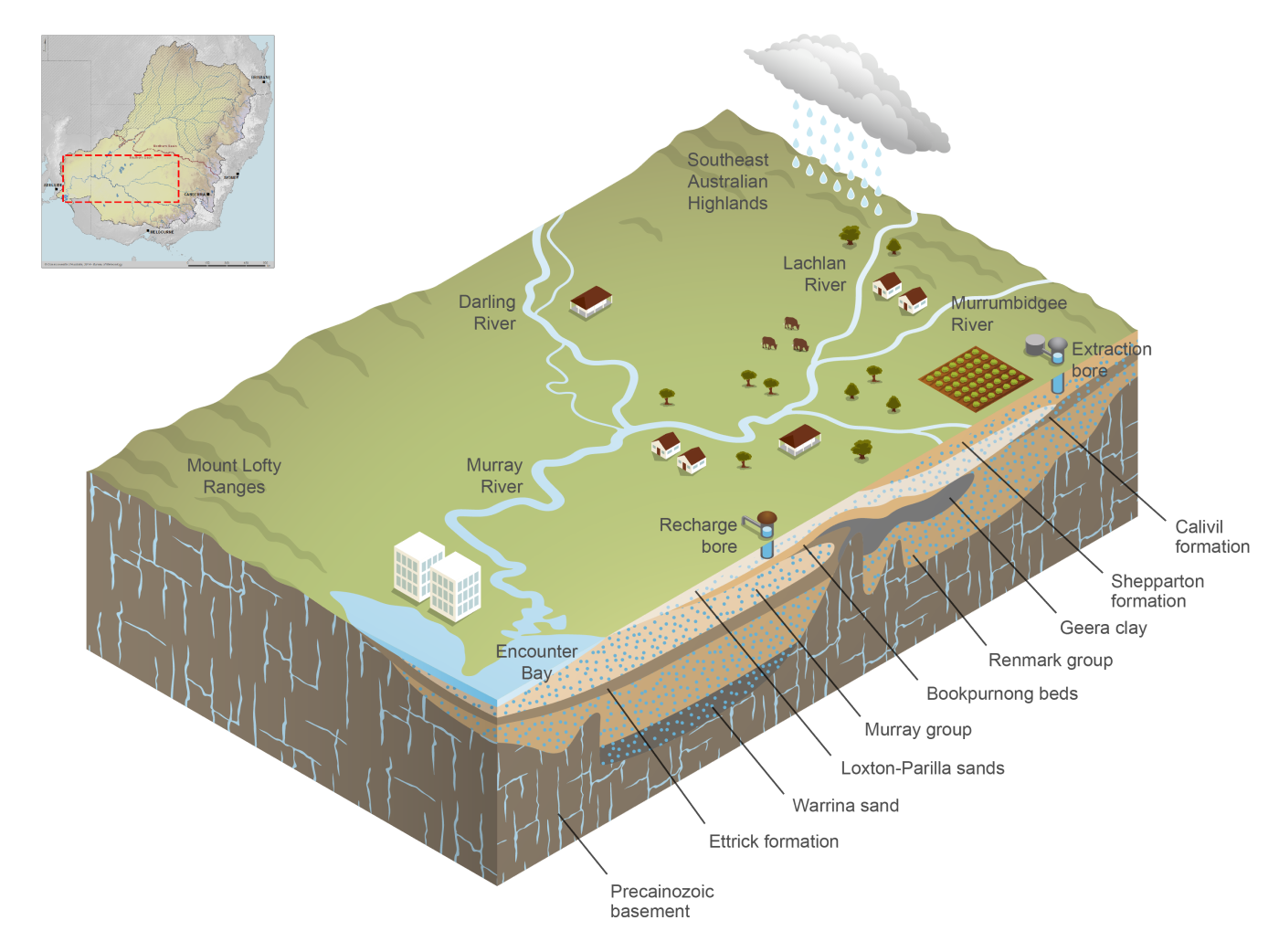
Figure R9 Cross-section diagram of groundwater aquifers in the southern part of the Murray–Darling Basin region
- Sedimentary and alluvial aquifers are the most important sources for groundwater supply; more than 95% of the region's extractions are from these aquifers.
- The GAB is the largest groundwater basin in Australia and underlies about one third of the Murray–Darling Basin. The GAB is recharged in small areas of the Murray–Darling Basin (along the southeastern edge of the GAB) where the aquifer layers are exposed at the land surface.
- Fractured rock aquifers occur in the region's highland areas. The volume of groundwater extracted from these aquifers is relatively low due to the difficulty of obtaining high yields from fractured rocks.
Other water resources and systems
Farm dams
- Farm dams (runoff dams) refer to landscape catchment storages used to harvest runoff, floodwater, or collect rainwater. They are an important water resource in the region; however, water held in farm dams is considered to be taken from the shared pool of water resources and, as such, is not included as part of the region's water assets.
- There are over 650,000 farm dams within the region (Srikanthan et al. 2015) holding approximately 2,168,000 ML (Sinclair Knight Merz 2007) or 9% of the total surface water storage capacity in the Murray–Darling Basin region.
- The water held in these farm dams is primarily used for agricultural and for stock and domestic purposes.
Water management
")
Surface water and groundwater management
Basin plan
- The Murray–Darling Basin Authority's (MDBA) Basin Plan was adopted by the Commonwealth Minister for Sustainability, Environment, Water, Population and Communities in November 2012.
- The plan sets long-term average sustainable diversion limits (SDLs) in 29 surface water SDL resource units and 80 groundwater SDL resource units. Compliance with the SDLs is required from 1 July 2019.
Surface water management plans
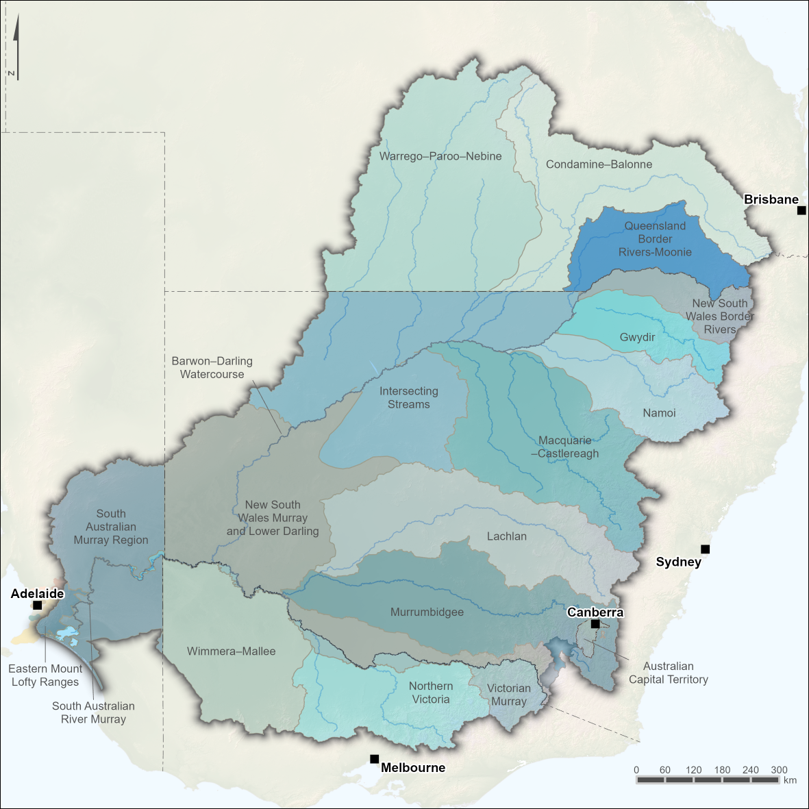
Figure R10 Water resource plan areas for surface water within the Murray–Darling Basin region
- There are 19 water resource plan areas to manage surface water resources within the region.
- Detailed maps for SDL resource units for surface water are available from the MDBA website.
Groundwater management plans
Figure R11 Water resource plan areas for groundwater within the Murray–Darling Basin region
- There are 19 water resource plan areas to manage groundwater resources within the region.
- Detailed maps for SDL resource units are available for groundwater and deep groundwater from the MDBA website.
Jurisdictional water management plans
Queensland
- Surface water and groundwater are managed under water plans for catchment areas in the Queensland section of the Murray–Darling Basin region.
- Draft water plans (which align with Basin Plan requirements) for the Condamine and Balonne, Border Rivers and Moonie catchments were released on 11 April 2018.
- Water plans, as well as information on updated water management arrangements, are available at the Queensland Government Mining, Energy and Water website.
New South Wales
- The water management instruments for surface water are water sharing plans. More information on these plans is available from the NSW Department of Industry website.
Australian Capital Territory
- The Water Resources Act 2007 (ACT) does not provide for statutory water management plans. Instead, the ACT Government has in place its own water management guidelines.
- More information on water management activities in the ACT is available on the Environment, Planning and Sustainable Development Directorate website, or in the Water management section in the Canberra region account.
Victoria
- Victoria's water entitlement and allocation framework provides the basis for the management of Victoria's water resources and governs how water can be abstracted and used.
- The Victorian Government has in place the Victorian Waterway Management Strategy, which determines state waterway health and policy targets.
- Two regional sustainable water strategies applicable to the Murray–Darling Basin region areas within Victoria are the Northern Region Sustainable Water Strategy and the Western Region Sustainable Water Strategy.
- More information on these strategies is available from the Department of Environment, Land, Water and Planning website.
South Australia
- There are a number of water allocation plans and regional natural resource management plans in place.
- More information on these plans is available from the Department for Environment and Water website, or from the Water management section in the Adelaide region account.
Border Agreements
- The New South Wales–Queensland Border Rivers Intergovernmental Agreement 2008 provides direction on water sharing and access, interstate trading, and managing the streamflows shared by both States, as well as water for the Darling River Basin. It also provides for broad agreement on the shared groundwater resources of the Dumaresq River groundwater area.
- The Border Groundwater Agreement between South Australia and Victoria specifies that the available groundwater shall be shared equitably between the two states along a 20-km wide designated area extending on both sides of the border.
Environmental water management
- Under the Australian Government Water Act 2007, the Basin Plan must contain an environmental watering plan.
- The Environmental water provisions outlined in the Basin Plan aim to achieve the best possible environmental outcomes using the increased but still finite amount of water made available.
Commonwealth environmental water programs
- The Australian Government has introduced the Sustainable Rural Water Use and Infrastructure Program (Australian Government Department of Agriculture and Water Resources 2016). Under this program, water savings are recovered for the environment through three main components: irrigation infrastructure projects; supply measures (by using water more efficiently); and water purchase.
- The water rights acquired by the Australian Government under the program become part of the Commonwealth environmental water holdings that are managed by the Commonwealth Environmental Water Holder. More information can be found on the Commonwealth Environmental Water Office website.
- The Living Murray Program established in 2002 is one of Australia's larger river restoration programs and aims to maintain the health of six icon sites along the Murray River. The program is a partnership among the Australian, New South Wales, Victorian, South Australian, and Australian Capital Territory Governments.
Jurisdictional water provisions
- Within each jurisdiction, water management plans address requirements to provide water for the environment by setting aside volumes that cannot be abstracted for consumptive use, as well as through releasing volumes from a storage in a controlled manner to achieve a set of conditions downstream.
Queensland
- The structure of the Queensland water plans is primarily aimed at providing planned environmental water rather than using held environmental water.
- The Australian Government has acquired entitlements in Queensland for environmental benefit.
New South Wales
- The Office of Environment and Heritage within the Department of Planning, Industry and Environment collaborates with many other partners to manage environmental water in New South Wales, including delivery of allocations from held environmental water and utilising planned environmental water to deliver environmental benefits.
Australian Capital Territory
- The Environment Planning and Sustainable Development Directorate has developed the Water Resources Environmental Flow Guidelines 2019.
- The objectives set in the guidelines are met by releases from the storages as planned, partly regulated surface water management, rather than using held environmental water.
Victoria
- The Victorian Environmental Water Holder holds entitlements that could be used for environmental benefits.
- A mixture of planned environmental water and held environmental water is delivered to achieve environmental benefits.
South Australia
- The South Australian Department for Environment and Water manages environmental water.
- A mixture of planned environmental water and held environmental water is delivered to improve the ecological health of the River Murray, including wetlands, floodplains, the Lower Lakes and the Coorong.
Cultural water management
- Section 10.54 of the Basin Plan states that 'A water resource plan must be prepared having regard to the views of Indigenous people with respect to cultural flows'.
- An example for cultural flow provision is the high security entitlements assigned in the Water Sharing Plan for the Murrumbidgee Regulated River Water Source 2016 for Aboriginal cultural water use.
Organisations responsible for water management
- Organisations responsible for water management in the region are shown below.
| Organisation | Responsibilities | ||||||||
| 1. environmental water management | |||||||||
| 2. water resource management | |||||||||
| 3. water availability determinations | |||||||||
| 4. water allocation announcements | |||||||||
| 5. wholesale water delivery | |||||||||
| 6. water infrastructure operations | |||||||||
| 7. administration and management of water legislation and licensing | |||||||||
| 8. administration and processing of water trades | |||||||||
| 9. water extraction and use approvals | |||||||||
| 1 | 2 | 3 | 4 | 5 | 6 | 7 | 8 | 9 | |
| Icon Water 1 | x | x | x | ||||||
| Environment Planning and Sustainable Development Directorate | x | x | x | x | x | x | |||
| National Capital Authority | x | ||||||||
1 For Canberra water supply.
| Organisation | Responsibilities | ||||||||
| 1. environmental water management | |||||||||
| 2. water resource management | |||||||||
| 3. water availability determinations | |||||||||
| 4. water allocation announcements | |||||||||
| 5. wholesale water delivery | |||||||||
| 6. water infrastructure operations | |||||||||
| 7. administration and management of water legislation and licensing | |||||||||
| 8. administration and processing of water trades | |||||||||
| 9. water extraction and use approvals | |||||||||
| 1 | 2 | 3 | 4 | 5 | 6 | 7 | 8 | 9 | |
| Department of Planning, Industry and Environment 1 | x | x | x | x | x | x | x | ||
| NSW Office of Environment and Heritage 2 | x | ||||||||
| WaterNSW 3 | x | x | x | x | |||||
| Murrumbidgee Irrigation 4 | x | x | x | x | |||||
| Murray Irrigation Limited 4 | x | x | x | x | |||||
| Jemalong Irrigation 4 | x | x | x | x | |||||
| Coleambally Irrigation Cooperative Ltd 4 | x | x | x | x | |||||
| Western Murray Irrigation Ltd 4 | x | x | x | x | |||||
| Local councils 5 | |||||||||
1 Focusses on policy, planning, and water market regulation, with oversight of major water infrastructure projects.
2 Environmental water management: and discretionary environmental water.
3 Leads customer activities.
4 Includes also trade prerogatives: process and approve water trades internal to the irrigation corporation. Intrastate trades and interstate trades require Water NSW approval .
5 In New South Wales, local councils hold water access entitlements to abstract water.
| Organisation | Responsibilities | ||||||||
| 1. environmental water management | |||||||||
| 2. water resource management | |||||||||
| 3. water availability determinations | |||||||||
| 4. water allocation announcements | |||||||||
| 5. wholesale water delivery | |||||||||
| 6. water infrastructure operations | |||||||||
| 7. administration and management water legislation and licensing | |||||||||
| 8. administration and processing of water trades | |||||||||
| 9. water extraction and use approvals | |||||||||
| 1 | 2 | 3 | 4 | 5 | 6 | 7 | 8 | 9 | |
| Department of Natural Resources, Mines and Energy | x | x | x | x | x | x | x | x | x |
| SunWater 1 | x | x | x | x | x | x | x | ||
| Local councils 2 | x | x | x | x | |||||
1 Only administers water allocation within the water supply schemes it manages and operates.
2 In Queensland, local councils may hold water licences, supplemented water allocations and/or unsupplemented water allocations.
| Organisation | Responsibilities | ||||||||
| 1. environmental water management | |||||||||
| 2. water resource management | |||||||||
| 3. water availability determinations | |||||||||
| 4. water allocation announcements | |||||||||
| 5. wholesale water delivery | |||||||||
| 6. water infrastructure operations | |||||||||
| 7. administration and management of water legislation and licensing | |||||||||
| 8. administration and processing of water trades | |||||||||
| 9. water extraction and use approvals | |||||||||
| 1 | 2 | 3 | 4 | 5 | 6 | 7 | 8 | 9 | |
| Adelaide and Mount Lofty Ranges Natural Resources Management Board | x | x | x | x | x | ||||
| Department for Environment and Water | x | x | x | x | x | x | x | x | x |
| SA Water | x | x | |||||||
| SA Murray–Darling Basin Natural Resources Management Board | x | x | x | x | x | ||||
| South East Natural Resources Management Board | x | x | x | x | x | ||||
| SA Arid Lands Natural Resources Management Board | x | x | x | x | x | ||||
| Central Irrigation Trust 1 | x | x | x | x | |||||
| Renmark irrigation Trust | x | x | x | x | |||||
| Creeks Pipeline Company Ltd | x | x | |||||||
| Local councils 2 | x | ||||||||
1 Responsibilities in administration and processing of water trades include internal water trade processing and approving within the irrigation trust. Intrastate and interstate trades require the Department of Environment, Water and Natural Resources's approval.
2 In South Australia, water access entitlements are held by SA Water, which has retail arrangements with local councils for water abstractions.
| Organisation | Responsibilities | ||||||||
| 1. environmental water management | |||||||||
| 2. water resource management | |||||||||
| 3. water availability determinations | |||||||||
| 4. water allocation announcements | |||||||||
| 5. wholesale water delivery | |||||||||
| 6. water infrastructure operations | |||||||||
| 7. administration and management of water legislation and licensing | |||||||||
| 8. administration and processing of water trades | |||||||||
| 9. water extraction and use approvals | |||||||||
| 1 | 2 | 3 | 4 | 5 | 6 | 7 | 8 | 9 | |
| Department of Environment, Land, Water and Planning 1 | x | x | x | ||||||
| Victorian Environmental Water Holder | x | ||||||||
| Goulburn Murray Water Corporation | x | x | x | x | x | x | x | ||
| Lower Murray Water Corporation | x | x | x | x | |||||
| Grampians Wimmera Mallee Water Corporation | x | x | x | x | x | ||||
| Local councils 1 | |||||||||
1 In Victoria, bulk water access entitlements are held by the water corporations, which are obliged to supply entitlements under the licences referred to in the schedules within their bulk entitlement conversion orders. Water and wastewater management functions under the Victorian Water Act 1989 are performed by statutory water corporations (not by local councils).
| Organisation | Responsibilities | ||||||||
| 1. environmental water management | |||||||||
| 2. water resource management | |||||||||
| 3. water availability determinations | |||||||||
| 4. water allocation announcements | |||||||||
| 5. wholesale water delivery | |||||||||
| 6. water infrastructure operations | |||||||||
| 7. administration and management of water legislation and licensing | |||||||||
| 8. administration and processing of water trades | |||||||||
| 9. water extraction and use approvals | |||||||||
| 1 | 2 | 3 | 4 | 5 | 6 | 7 | 8 | 9 | |
| Murray–Darling Basin Authority | x | x | x | x | |||||
| Commonwealth Environmental Water Office 1 | x | ||||||||
| Snowy Hydro Ltd 2 | x | x | x | ||||||
1 Manages Commonwealth environmental water holdings under the Australian Government Water Act 2007.
2 Transfers water into the Murray–Darling Basin region.
Water rights
")
Operating rules and constraints
- Inter-jurisdictional arrangements, in particular the Murray–Darling Basin Agreement and State and Territory water legislations (including state water resource plans), plan and manage the Murray–Darling Basin region's water resources and impose operating rules and constraints.
- The Murray–Darling Basin Cap (the Cap) was established in 1995 and has provided a framework for water sharing in the Murray–Darling Basin region. The Cap aims to limit yearly diversions to the volume that would have been diverted at the 1993–94 development level in most valleys.
- The Basin Plan adopted in November 2012, aims to balance the water needs of the environment and other uses through the introduction of 29 surface water sustainable diversion limit (SDL) resource units and 80 groundwater SDL resource units for the whole region.
- It is anticipated that in coming years those valleys managed under the Cap framework will transition to management within an SDL framework as set out in the Basin Plan.
- Each State and Territory can differ in the way they manage water in the Murray Darling Basin. Further information can be obtained from the Queensland Department of Natural Resources, Mines and Energy, the NSW Department of Planning, Industry and Environment, the ACT Environment Planning and Sustainable Development Directorate, the Victorian Department of Environment, Land, Water and Planning, and the SA Department for Environment and Water.
Water entitlements and other statutory water rights
- Water access entitlements (WAEs), when added to other statutory (non-entitled) water rights (e.g. basic rights for stock and domestic purposes), represent the total volume of water rights that have been granted for use.
- A percentage of an entitlement may be available for abstraction during the year, subject to allocations, announcements and other licence conditions; however, water availability under statutory rights is normally not subject to allocation announcements.
- In each State and Territory, WAEs and water allocation planning exist in a framework of State and Territory legislation and water resource plans. Terminology and mechanisms within these frameworks vary between the States and the Territory.
- In the Murray–Darling Basin region, WAEs may be issued within regulated and unregulated systems (called 'supplemented' and 'unsupplemented' systems in Queensland). WAEs in unregulated systems and regulated systems with continuous accounting rules can specify maximum volumes that can be abstracted, either in one year or over a period of several years.
- In some jurisdictions within the region, diversions of water are possible only during extreme events such as floods. These diversions are known as off-allocation diversions, supplementary flows, water harvesting, overland flows or spillage sales.
- As part of their commitment to the National Water Initiative, States and Territory separate the bundled components of the right to access a share of the water resource (WAEs, where they exist) from the land and from the other water rights such as the right to abstract water (or have it delivered), the right to use water for a given purpose and the right to build a work.
- Across the Murray–Darling Basin region, licences have been issued for hydropower generators. They are not reported upon in the National Water Account as they are non-consumptive and not expressed in terms of volume.
- For more information on water rights specific to each State and Territory, visit the relevant National Water Account regions: Queensland (South East Queensland region); New South Wales (Sydney region); Australian Capital Territory (Canberra region); Victoria (Melbourne region) and South Australia (Adelaide region).
Water allocations
- The water sharing rules and water accounting policies in effect vary throughout the Murray–Darling Basin region.
- Water allocation is the predominant mechanism to share surface water regulated flows. In systems with annual accounting rules, allocation announcements are made by the relevant water authority ranging from 0–100% availability, depending upon the class of entitlement and water source.
- On 1 July each year, subsequent to allocation announcements and carryover rules, the water account of entitlement holders is credited with their water allocation and the carried over volume from the previous year. This volume of water may be abstracted, traded or stored.
- Different carryover rules in each State and Territory and management plan define the amount of allocation that can be carried over and accessed in the next water year.
- Unregulated surface water flows can only be accessed once predetermined flow conditions are met and in a manner that is consistent with diversion conditions specified in the works or use licences by the relevant jurisdiction.
- An alternative water sharing method, referred to as 'continuous accounting' that allows users to have a share of system storage capacity and inflows, operates in several water resource plan areas throughout Queensland and New South Wales.
- Access to groundwater is either made under formal allocation announcement or by default 100% of the entitlement unless restrictions apply.
- For more information on water allocations rules specific to each State or Territory, refer to the relevant National Water Account regions: Queensland (South East Queensland region); New South Wales (Sydney region); Australian Capital Territory (Canberra region); Victoria (Melbourne region) and South Australia (Adelaide region).
Trades and water rights transfers
Water market rules: interstate trading
- Water users are able to trade water entitlements and allocations in the Murray–Darling Basin region. Trading of entitlements and allocations occurs between and within valleys, and across State and Territory borders.
- Interstate surface water trade is primarily available in the southern part of the Murray–Darling Basin region in New South Wales, Victoria, and South Australia. In the northern part, interstate surface water trade is available between New South Wales and Queensland within the Border Rivers water resource plan areas.
- Trade in the southern part of the region is conducted under Schedule D of the Murray–Darling Basin Agreement, which appears as Schedule 1 to the Australian Government Water Act 2007.
- The framework for interstate trade in the Border Rivers water resource plan areas is provided in the New South Wales–Queensland Border Rivers Intergovernmental Agreement 2008 (New South Wales Government and Queensland Government 2008).
- Since July 2007, the interstate allocation trade market in the southern part of the region has resulted in the net movement of water into South Australia, due in part to the extended drought.
- Allocation trading mechanisms have also been used to facilitate the delivery of environmental water across zones and State and Territory borders, particularly in South Australia in recent years.
Water market rules: inter-valley and within-valley trading
- Inter-valley trading rules are defined in State and Territory legislation, water resource plans and the Murray–Darling Basin Agreement. Some interstate trading rules also cover inter-valley trading.
- Inter-valley water trading is generally available within the southern part of the region rather than in the northern part.
- Surface water trading within valleys is usually available within regulated systems. Groundwater trading within an aquifer is available in limited areas, usually only where a water resource plan has been developed.
Basin Plan and other water trading rules
- The Basin Plan water trading rules apply alongside existing State and Territory and irrigation infrastructure operator trading rules.
- In addition, the Commonwealth Water Minister makes the water market rules under the Water Act. The Australian Competition and Consumer Commission applies these rules through its monitoring, enforcement, advisory and, price-setting roles.
Restrictions on trade
- Generally, trade of water entitlements between and within surface water resource systems is restricted if there are physical constraints, environmental considerations, hydrologic connections, water supply considerations, or low hydraulic connectivity.