South East Queensland: Geographic information
The South East Queensland region has an extensive network of water bodies consisting of creeks, rivers, wetlands, lakes, bays and ocean. The Moreton Bay area contains wetlands of significant ecological importance. Surface water is the primary source of consumptive water use in the region, primarily for urban supply. Sustainable water supply for the region is provided by the South East Queensland Water Grid.

General description
Area: 24,283 km²
Population: 3.2 million (Australian Bureau of Statistics [ABS] 2011)
The South East Queensland region is located on the southeast coast of Queensland (Figure R1). It is home to 72% of Queensland's population (ABS 2011).
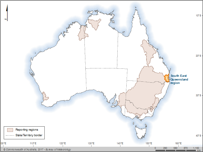
Figure R1 The South East Queensland region within Australia
The South East Queensland region shown in Figure R2 is bounded by the New South Wales–Queensland State border in the south, the Pacific Ocean in the east, the Great Dividing Range in the west and the headwaters of the Brisbane River and Mary River in the north. Mountains exist along the western and southern edges of the region, while coastal plains dominate the east. It contains several large rivers that discharge into the Pacific Ocean.

Figure R2 Contextual map of the South East Queensland region
Region definition
The South East Queensland region covered in this report includes four water resource plan areas: Gold Coast, Logan, Moreton and part of the Mary Basin (see Figure R8 in Water management). The region is physically defined by the surface water catchments and includes all water resources within or beneath the physical area as shown in Figure R2.
For the purposes of this report, the region includes water stored in:
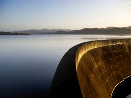
- surface water storages
- pipes and infrastructure as part of the urban water supply and wastewater collection
- groundwater aquifers.
The region excludes water stored in:
- off-channel water storages and rainwater tanks, such as farm dams and private commercial water storages used to harvest runoff or collect rainwater
- the landscape, such as soil moisture
- wetlands that are not connected to rivers
- the Great Artesian Basin (GAB).
Land use
The South East Queensland region is the most densely populated area of Queensland. Resident populations of major cities, towns and urban centres within the region include (ABS 2011):
- Brisbane: 1,089,879
- City of Gold Coast: 515,202
- Moreton Bay: 390,051
- Sunshine Coast: 306,909
- Logan: 287,474.
A number of small towns are interspersed throughout the rest of the South East Queensland region including Beaudesert, Blackbutt, Esk, Gatton, Kilcoy, Kooralbyn, Laidley and Yarraman. Urban land use accounts for 8% of the land area in the region (Figure R3).
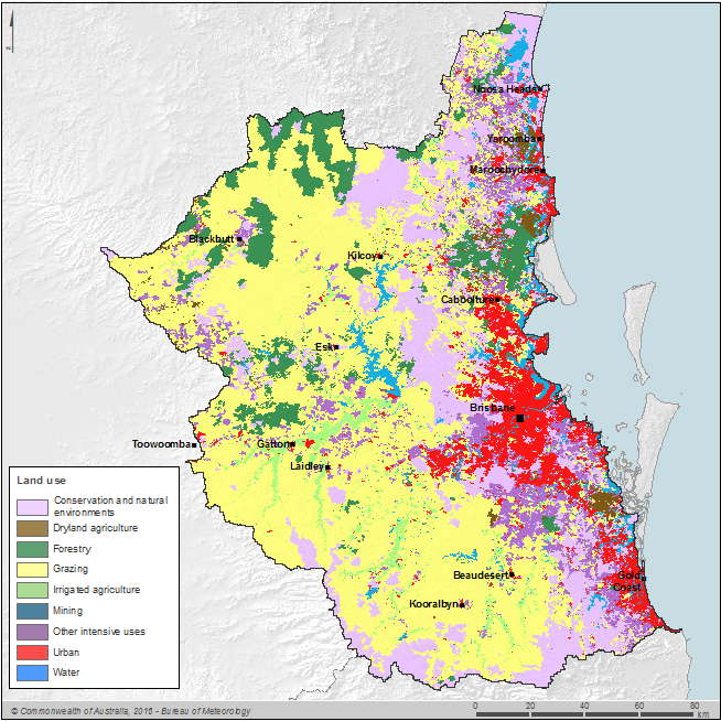
Figure R3 Land use in the South East Queensland region
Source: Interpreted from Australian Government Department of Agriculture 2016.
Grazing is the dominant land use, making up more than 50% of the land area in the region. Conservation and natural environments make up 18% of land use throughout the region, while forestry and agriculture account for 12% of the land area (Figure R3).
Land use activities that are major water users in the region include irrigated agriculture and urban (Queensland Government Department of Natural Resources, Mines and Water 2005, 2006a, 2006b; Queensland Government Department of Natural Resources and Water 2007).
Significant aquatic ecosystems
Wetland systems of international and national importance are located in the South East Queensland region (Figure R4). Further information can be found on the Department of Environment and Heritage Protection website. The wetlands of Moreton Bay adjacent to the region and affected by outflows from the region are listed in the international Ramsar Convention of Wetlands. They cover in excess of 3,200 km², most of which are on coastal islands or near shore marine areas. The habitat ranges from perched freshwater lakes and sedge swamps on the offshore sand islands to intertidal mudflats, marshes, sandflats and mangroves next to the bay's islands and mainlands.

Figure R4 Nationally important wetlands and Ramsar wetlands in the South East Queensland region
Significant Indigenous cultural places and practices
Prior to European settlement, a large number of Indigenous people lived in the South East Queensland region (Jabree Ltd 2013). It is estimated that the watershed areas alone of the Logan, Albert, Coomera and Nerang rivers contained 1,500 to 2,000 Indigenous communities.
The Indigenous people believe that spiritually they are part of the landscape, of which they emphasize four separate elements: landscape boundaries, pathways, biodiversity matters and important sites/areas (Choy et al. 2011). These four elements relate in different ways to water within South East Queensland.
Natural boundaries include creeks, rivers, channels, mountain ranges and invented boundaries created through myth and stories for community safety purposes (including forbidden areas, dangerous swamps, lakes and snake habitats).
The Indigenous people used pathways formed by passages of land and water to move through the landscapes. Usually valleys, wildlife corridors, beaches, waterways, channels, currents and tides are recognised as pathways of importance to them.
The Indigenous people had three main ways of identifying biodiversity in the regional landscape. These were interpretation of the 'bush calendar' (including animal behaviour, flowering seasons and weather), interpretation of indicators and warning signs (using fauna), and presence and absence of totemic species and habitats. Using these techniques, they developed an acute sense of identifying small biodiversity changes. In order to track the changes, they use a 'totem' which is a typical animal or plant species that is in some way connected to a clan group, family or individual. This builds up a strong spiritual connection between the regional landscape and each individual. It is believed that the totem can serve as an indicator of the environmental changes (Choy et al. 2011).
Water resources
Most of the region's water supply comes from surface water. Groundwater use is limited to various alluvial aquifers located along river valleys. Desalinated and recycled water resources within the region have been developed in recent years.
Based on the water use in relation to total inflows, available water resources and sustainable yield in the Brisbane water supply area, the water resource is moderately developed with surface water management plans in place across the entire region (Australian Government National Water Commission 2007).
Groundwater resources within the region are being developed, with groundwater management areas now present across many high-use alluvial aquifers. It is expected that additional groundwater management areas may be introduced as groundwater use is further developed. Agriculture is the main groundwater use within the South East Queensland region.
Water stored within the region's surface water storages is primarily used for urban supply. Two of the larger storages—Wivenhoe and Somerset—have additional flood storage compartments above their drinking water storage capacity, which are used for flood mitigation (see Seqwater website for more information).
Recycled water and desalinated water can supplement the surface and groundwater resources for urban use and power supply within the region.
Surface water
Figure R5 shows mean monthly flow and mean monthly rainfall for the five main rivers within the South East Queensland region: Albert River at Bromfleet (Station 145102B), Bremer River at Walloon (Station 143107A), Brisbane River at Gregors Creek (Station 143009A), Logan River at Yarrahappini (Station 145014A) and North Maroochy River at Eumundi (Station 1410009A).
Typically, these rivers have perennial flow, except Bremer River, which may occasionally cease to flow. The seasonal flow characteristics of these rivers reflect the rainfall pattern of the South East Queensland region, where most the rainfall occurs between November–March. Figure R6 provides the location of the key flow gauging stations along the main rivers within the region.
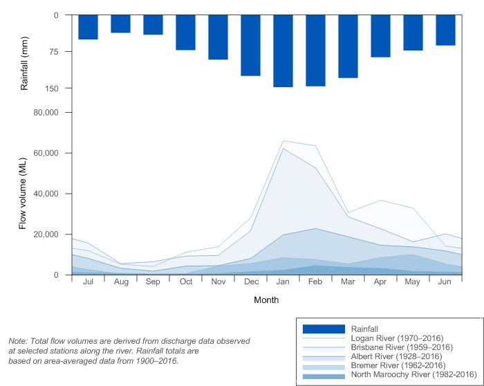
Figure R5 Mean monthly flow along the rivers and mean monthly rainfall for the South East Queensland region
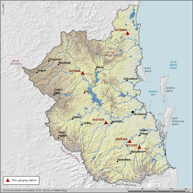
Figure R6 Key flow gauging stations along the main rivers within the South East Queensland region
Storages
Surface water storages are an important water source for water supply in the South East Queensland region. The storages which are managed by Seqwater, Toowoomba Regional Council and Tarong Energy, are shown in Figure R7. The larger storages in the region are Wivenhoe (1,165,238 ML), Somerset (379,849 ML), Hinze (310,730 ML) and North Pine (214,302 ML). Together they represent approximately 77% of the region's storage capacity. Some of the smaller public storages have not been included in the account and it's estimated these comprise less than 1% of the region's total storage capacity.
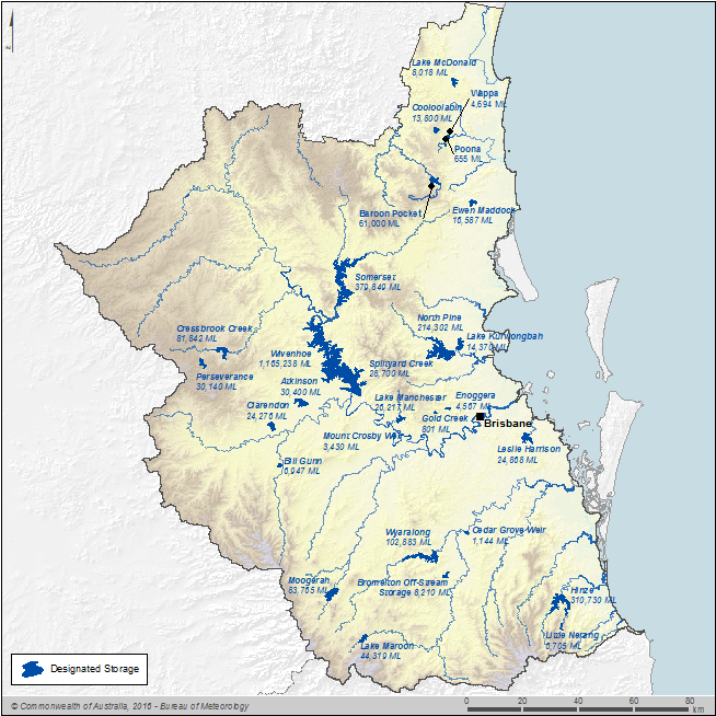
Figure R7 Surface water storages in the South East Queensland region
Further information on the region's storages, including current levels and volumes for reservoirs, is given on the Bureau of Meteorology's Water storage website. Note that the volumes reported on the Water storage website exclude the dead storage volumes.
Groundwater
The primary source of water for the irrigation-dominated upland valleys of the South East Queensland region (such as the Lockyer Valley) is groundwater extracted from alluvial aquifers. The Lockyer Valley alluvial aquifer overlies the Great Artesian Basin (GAB) but is not a part of it, and is managed as a separate resource under Moreton water resource plan. The Cooloola Sandmass aquifer of the Mary Basin water resource plan area contains a large volume of good quality subartesian water and the area is of high conservation value. Cooloola Shire Council primarily sources groundwater for the Rainbow Beach town water supply, as well as for commercial and domestic purposes in other adjacent areas. Groundwater extraction is strictly monitored in order to avoid potential seawater intrusion and impacts on the groundwater–fed wetland systems (Queensland Government 2006). In the south, groundwater use is minor. In certain areas, groundwater throughout the region is sourced from local confined aquifers for agricultural and domestic uses. Shallow bores are used to access groundwater for garden-watering on the coastal plain.
The region's groundwater layers can be categorised into the following types:
- Palaeozoic age basement rocks
- Early–Middle Triassic age metasedimentary rocks
- Permo–Triassic age intrusive rocks
- Mesozoic age sedimentary basins
- Mesozoic age volcanics
- Tertiary age sedimentary basin sediments
- Tertiary age basalts
- Quaternary age valley alluvial fills.
The GAB (Queensland Government Department of Natural Resources and Mines 2016a), one of the world's largest groundwater resources with an estimated total stored volume of 65,000 million megalitres, underlies 22% of Australia's land mass including a large portion of Queensland. The groundwater resources in the GAB in Queensland are managed under the Great Artesian Basin Plan 2006 (Queensland Government Office of the Parliamentary Counsel 2015a) and the Great Artesian Basin Resource Operations Plan 2007 (Queensland Government Department of Natural Resources and Mines 2016b). This divides the Queensland component of the GAB into 25 management areas. One of these areas, the Clarence-Moreton management area is located partially within the South East Queensland region and is made up of Walloon Coal Measures, Marburg Sandstone and Helidon Sandstone. The Clarence–Moreton management area is 400 km in length and 125 km in width; it extends from Toowoomba in the west to Darr Creek in the northwest, Esk in the north, Ipswich in the east and through to Rathdowney in the south (Queensland Government Department of Natural Resources and Mines 2016b). It underlies the Lockyer Valley, Bremer River Valley and Teviot Brook catchment.
Desalinated water
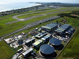
The Gold Coast Desalination Plant is located at Tugun on the Gold Coast. Desalinated water is blended with other Gold Coast drinking water supplies and joins the South East Queensland Water Grid (SEQ Water Grid). When running at 100% capacity, the desalination plant is capable of providing 125 ML of water per day to the South East Queensland region's drinking water supplies.
From December 2010 the plant was operating in 'hot standby' mode where the plant produced 25 ML/day, twice a week; however, since January 2016, the plant has been run three times each fortnight and produces approximately 5 ML of water per run.
In addition to its reduced frequency run time operations, the Gold Coast Desalination Plant is called on to augment the South East Queensland region's drinking water supply, particularly during weather events or interruptions to supply in other parts of the SEQ Water Grid. The plant can be called on to run at 33% of capacity with 24 hours notice and at 100% capacity with 72 hours notice.
Water systems
Urban water system
Major urban infrastructure within the South East Queensland region is illustrated in maps of Seqwater major assets (Seqwater 2016a).
Water service providers, including the Council of the City of Gold Coast, Logan City Council, Redland City Council, Queensland Urban Utilities, and Unitywater, supply potable water to most residents in the region via the South East Queensland Water Grid (SEQ Water Grid). A number of the region's residents live in communities where the drinking water supplies are not directly connected to the water grid (referred to as off grid communities). In these off grid communities, water is sourced and treated locally.
The SEQ Water Grid was established in July 2008 to connect water supplies and treatment facilities across the region. The grid comprises an infrastructure network of treatment facilities and two-way pipes that move water between new and existing sources across the region. It provides the region with access to more water sources and is dependent on climatic conditions (surface water storages) and resilient to climatic conditions (desalinated and purified recycled water). The network includes more than 600 km of reverse-flow pipelines, including the 47 km bi-directional Northern Pipeline Interconnector that moves water from Noosa to Coolangatta in the south.
Key components include 26 major surface water storages, 51 weirs, 37 operational water treatment plants, 22 bulk water pump stations, 18 bulk water reservoirs and 14 groundwater bore fields. The roles of water retailers within the South East Queensland region are provided in Organisations responsible for water management.
There is also a water pipeline between Wivenhoe Reservoir and Cressbrook Creek for supplying raw water to Toowoomba Regional Council, if there is any shortage of water.
Recycled water
Two main recycled water schemes exist within the South East Queensland region: recycled water treatment plant at Pimpama–Coomera of the City of Gold Coast, and the Western Corridor Recycled Water Scheme extending from Brisbane's southwest suburbs towards the city of Ipswich.
Gold Coast residential supply
Class A+ recycled water is supplied to residential (for toilet-flushing and external use) and non-residential (industrial use) in the Pimpama–Coomera area of the City of Gold Coast .
The recycled water treatment plant is part of the Pimpama–Coomera Waterfuture Master Plan.
Power station supply
The Western Corridor Recycled Water Scheme was used to provide purified recycled water to power stations, fertiliser industries and potentially agricultural users. The scheme was decommissioned on 31 March 2015 and is now in care and maintenance mode (Parliamentary Committees 2015).
Prior to its decommission in March 2015, the scheme formed part of the SEQ Water Grid and the power stations, namely the Swanbank B and Swanbank E power stations (located within the South East Queensland region) and the Tarong and Tarong North power stations (located outside the South East Queensland region) were the main customers for the recycled water. Treated effluent from six wastewater treatment plants was further treated to purify recycled water at three separate advanced water treatment plants located at Bundamba, Gibson Island and Luggage Point.
When all three advanced water treatment plants were operating at capacity, the Western Corridor Recycled Water Scheme had a capacity of 232 ML/day, subject to the availability of inflowing water from the wastewater treatment plants that supply the advanced water treatment plants.
Farm dams
The Queensland Government Department of Environment and Resource Management has indicated that there are approximately 1,700 farm dams within the South East Queensland region with a combined estimated storage volume of 59,080 ML.
The information was extracted from the Large Referable Farm Dam Identification Program dataset (Queensland Government Department of Energy and Water Supply), which identified farm dams greater than 0.25 ha in area using Landsat 30 m imagery. Some dams may have been omitted during this selection process due to the remote sensing methods used. The data is not intended as a complete count of farm dams but is an indication of the number of larger farm dams within the South East Queensland region.


