


Sydney: Region description
- The region is located on the New South Wales coast, and includes Sydney—Australia's largest city by land area, and as of the 2021 Census, the most populous.
- The Hawkesbury-Nepean River is the most significant river system in the region, encompassing the Coxs River, which flows into Warragamba Reservoir—the region's largest storage.
- Surface water is the main water source, mainly for urban and agricultural uses, which are supplied via an extensive storage network.
For further information about the region scroll down this page or click on the links below:
Geographic information
")
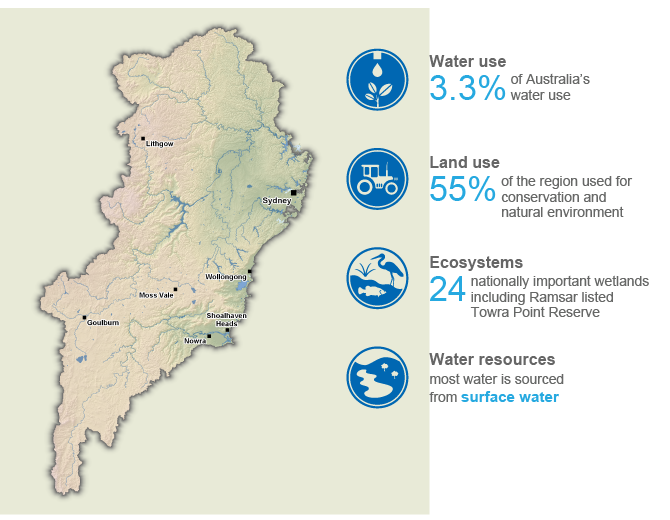
General description
Area: 30,800 km²
Population: 5.71 million (Australian Bureau of Statistics 2021 - Greater Sydney Area*)
*Also includes the Illawarra region and Southern Highlands & Shoalhaven region
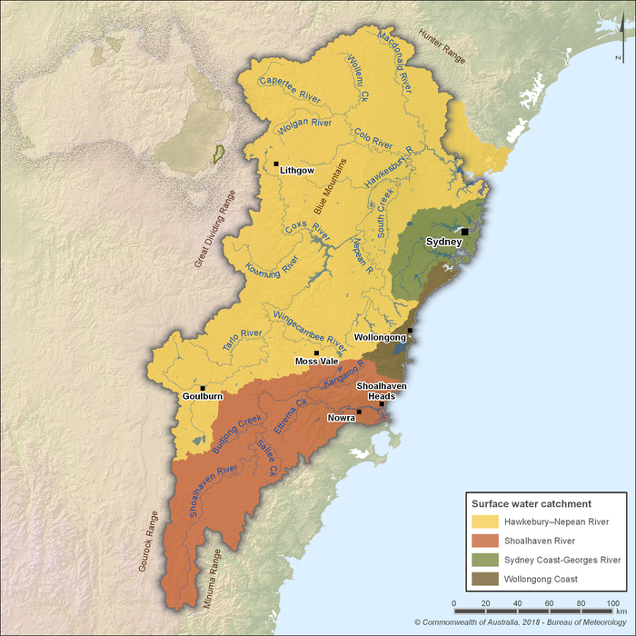
Figure R1 Contextual map of the Sydney region
- The Sydney region is defined by most of the Hawkesbury-Nepean River catchment, as well as the Shoalhaven River, Sydney Coast-Georges River, and Wollongong Coast catchments.
- Home to roughly 70% of New South Wales' total population, most of whom reside within the Sydney metropolitan area, it is the most populus region in the country, as of the 2021 Census.
- The Hawkesbury-Nepean River catchment is the most significant river system in the region, providing water to large parts of conservation and natural environments.
Land use
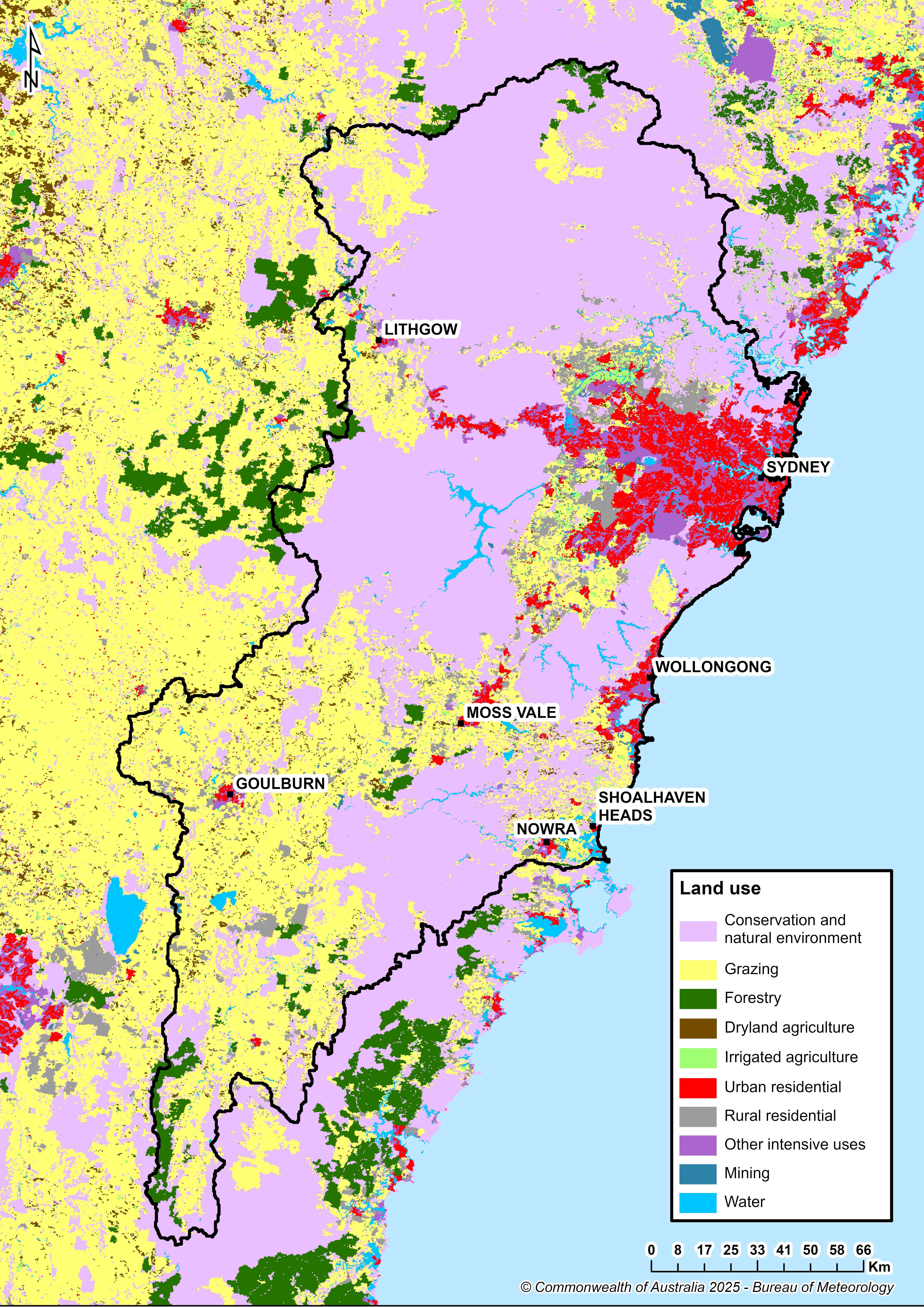
Figure R2 Land use in the Sydney region
- Conservation and natural environments is the most common land use, comprising 55% of the region's area, while 25% of the region is used for grazing.
- Urban centres make up 8% of the region's total area, which includes most of the region's population.
Significant aquatic ecosystems
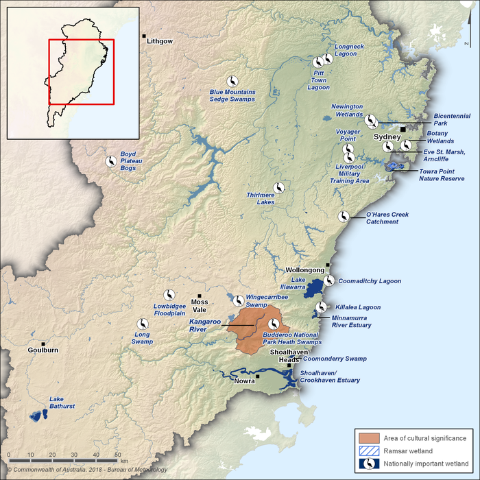
Figure R3 Significant wetlands and cultural places in the Sydney region
- The Towra Point Nature Reserve is an estuarine Ramsar wetland which lies on the northern side of Kurnell Peninsula, forming the southern and eastern shores of Botany Bay, and is approximately 16 kilometres south of the Sydney city centre in New South Wales.
- There are also 23 Nationally Important Wetlands listed in the Directory of Important Wetlands in Australia within the region.
- Numerous surface water sources are ecologically important, including endangered ecological communities found in the Maroota Sands Swamp Forest and Sydney Freshwater Wetlands.
- The Water Sharing Plan for Greater Metropolitan Region Unregulated River Water Sources 2023 includes environmental flow rules and extraction limits to protect high-value aquatic ecosystems, including key rivers, wetlands, and groundwater-dependent habitats.
- According to the Water Sharing Plan for Greater Metropolitan Region Groundwater Sources 2023, 19 high priority groundwater-dependent ecosystems have been identified within the region, such as the Botany Wetlands, Lake Bathurst, and Towra Point Estuarine Wetlands, as well as 21 high priority karst environments, such as those found in the major cave systems of Bungonia, Jenolan, and Wombeyan.
Significant Aboriginal cultural places
- The Sydney region is home to numerous significant Aboriginal cultural sites, including:
- Kangaroo Valley, encompassing the Kangaroo River, recognised for its significant cultural importance. Its rich environment and strategic location served as a natural meeting place for Aboriginal communities, where groups such as the Wodi Wodi and Jerrinja peoples shared resources, traded, and engaged in cultural practices.
- Tank Stream, once a freshwater tributary of Sydney Cove, served as a vital water source for the Gadigal People of the Eora Nation. The stream provided freshwater, fish, and other resources essential for daily life. Today, its remnants exist as little more than a stormwater drain beneath Pitt Street in the Sydney CBD.
- The Parramatta Sand Body, a fluvial sand terrace along the Parramatta River, provides substantial archaeological evidence of Aboriginal occupation, including stone artefacts dating back thousands of years. It is thought to have been part of the territorial lands of the Boromedegal People, who accessed both freshwater and saltwater food resources such as ducks, eels, shellfish, crayfish, fish, and turtles.
- The Nepean River, flowing through Darug Country, has been central to Aboriginal communities for millennia. Archaeological sites along its banks, such as Cranebrook Terrace, have yielded stone artefacts dating back over 40,000 years, indicating early Aboriginal occupation. The river's ecosystem provided vital resources, including fish, eels, and freshwater shellfish, sustaining the Darug People.
- The Hawkesbury River, known traditionally as Dyarubbin, traverses the lands of the Darug and Darkinjung peoples. Its expansive waterways and fertile surrounds supported abundant food sources and were integral to cultural practices. The river's significance is evident in numerous Aboriginal sites along its course, including locations such as Muogamarra Nature Reserve and the Sackville Reach Aboriginal Reserve, where rock engravings, occupation sites, and axe-grinding grooves highlight the enduring connection of Aboriginal communities to the river.
Water resources
- Surface water is the primary water source in the region, supplying urban and agricultural needs. Flows from several major rivers are highly regulated through a network of dams and weirs.
- While Australia's per capita surface water storage capacity is among the highest globally, the Sydney region's capacity is comparatively lower due to its large population base. However, it still remains higher than many countries, reflecting Australia's efforts to conserve and manage surface water availability for populated areas.
- Other water sources include groundwater, desalinated water from the Sydney Desalination Plant (servicing the Sydney metropolitan area), recycled water supplied by Sydney Water and local councils, and inter-basin transfers from the Fish River Water Supply Scheme.
Surface water
Rivers
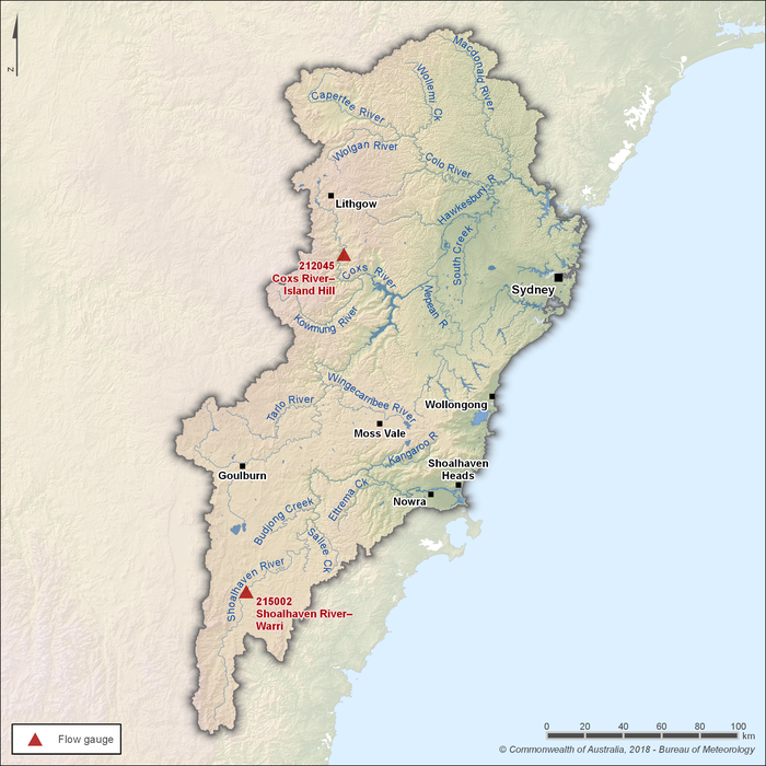
Figure R4 Streamflow gauging stations along the main rivers within the Sydney region
- There are three main river systems within the Sydney region: the Hawkesbury–Nepean River, the Shoalhaven River, and the Illawarra and metropolitan Sydney catchments.
- Of these, the Hawkesbury–Nepean and Shoalhaven river systems are the two primary sources of streamflow in the region.
- Two gauging stations—Shoalhaven River at Warri (215002) and Coxs River at Island Hill (212045)—are used to represent seasonal flow patterns in the rivers. Streamflows upstream of these sites are unregulated and not influenced by diversions for consumptive use.
- The Coxs River flows into the region's largest storage—Warragamba Reservoir (Lake Burragorang).
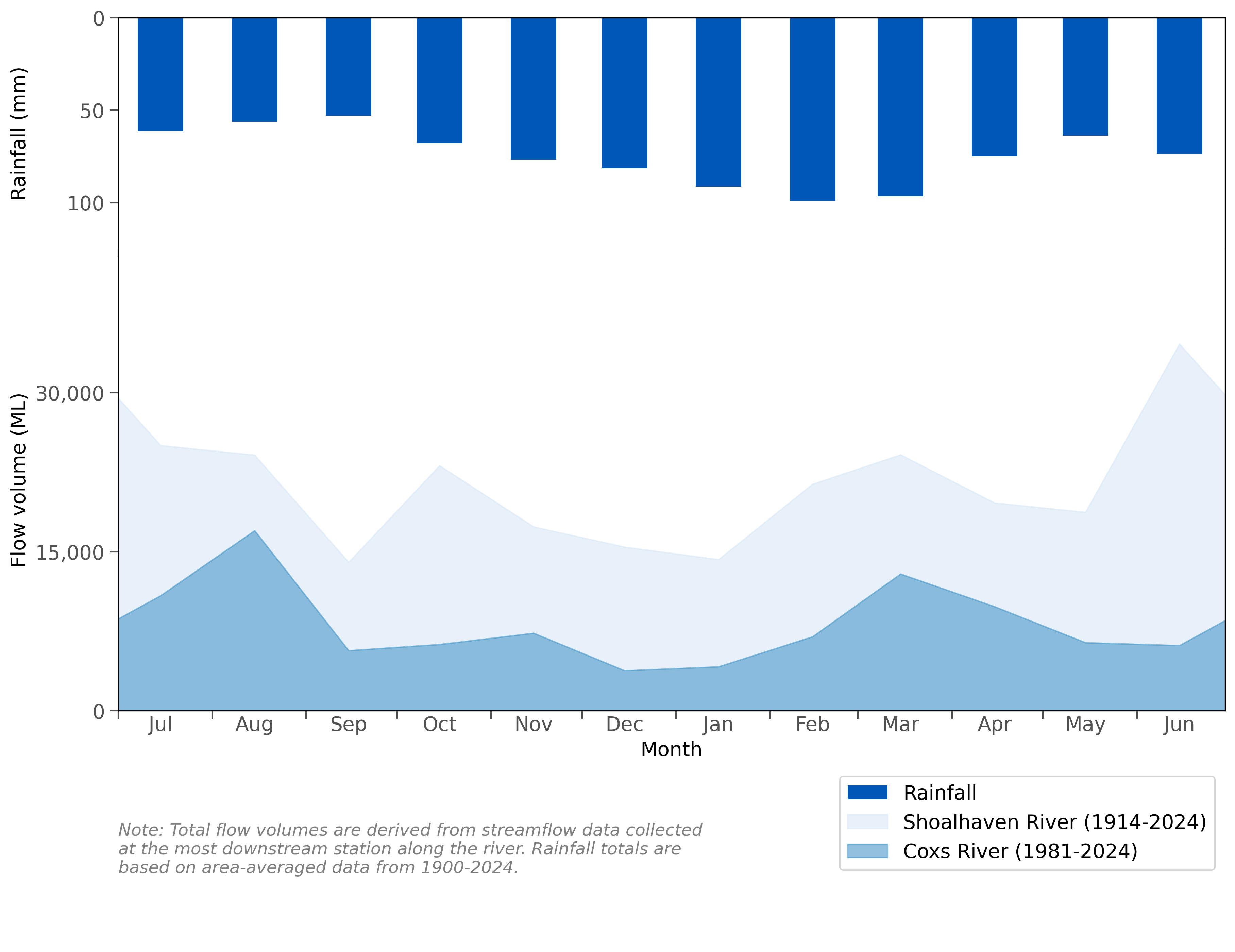
Figure R5 Mean monthly flows along the Coxs River (part of the Hawkesbury–Nepean River system) and Shoalhaven River and mean monthly rainfall for the Sydney region
- Rainfall is generally evenly distributed throughout the year, though higher totals are more common during summer and autumn (December to May).
- Streamflows in the region's rivers are typically perennial, reflecting the relatively consistent year-round rainfall.
- Further information on the region's rainfall and streamflow conditions is provided in the Climate and water section of this account.
Storages
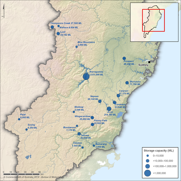
Figure R6 Major storages in the Sydney region; capacity of each storage is also shown
- An extensive network of dams and weirs is used to capture streamflows and secure water supplies across the Sydney region.
- The region's largest surface water storage, Warragamba Reservoir, accounts for approximately 70% of the region's total surface water storage capacity.
- Water from the Shoalhaven catchment can be diverted to the Hawkesbury-Nepean catchment via a series of storages, including Lake Yarrunga (formed by the Tallowa Dam), Bendeela Pondage, and Fitzroy Falls Reservoir.
- The Upper Nepean Scheme—comprising Cataract, Cordeaux, Avon, and Nepean dams—contributes water to the Illawarra, Macarthur, and Greater Sydney areas.
- Recent upgrades to Warragamba Dam include the installation of environmental flow release infrastructure, allowing up to 3,000 megalitres per day to be released to improve the ecological health of the Hawkesbury-Nepean River.
Inter-region/intervalley transfers
- The Fish River Water Supply Scheme, managed and operated by WaterNSW in collaboration with the Fish River Customer Council, delivers water from Oberon Dam and Duckmaloi Weir to customers within the Sydney region. Water from the scheme supplies the Lithgow and Oberon councils, the Wallerawang and Mount Piper power stations, approximately 230 properties along the pipeline, and provides supplementary supply to the upper Blue Mountains.
- Constructed in the 1940s, the scheme was established by Act of Parliament in 1945 as a Trading Undertaking of the NSW State Government to address chronic water shortages in towns such as Lithgow, Wallerawang, Portland, and Oberon, exacerbated by the 1940s drought. Today, it continues to provide a reliable water supply for industrial operations, local councils, and power generation.
- It is the only water supply scheme in eastern Australia that transfers western-flowing water east of the Great Dividing Range, supplying water by gravity through a 236-kilometre network of pipelines and tunnels.
- There are also intervalley water transfers within the region, between the Shoalhaven, Hawkesbury-Nepean, and Sydney coastal catchments. As these transfers occur within the region, they are not quantified individually in this account, but are included in the overall surface water store balance.
- These are physical water transfers and are distinct from water trading, which is governed by separate regulatory frameworks outlined in the water sharing plans.
Desalinated water
- The Sydney Desalination Plant was constructed between 2007 and 2010 to support Sydney's water supply during the Millennium Drought. At the drought's peak in 2006, the region's accessible surface water storages dropped to 33.8%, prompting the need for a rainfall-independent water source to secure future water supply needs for the region.
- Following its completion in 2010, the plant operated until 2012, when the NSW Minister for Finance and Services directed the plant to cease operation after surface water storages across the region reached 90% capacity. Production was directed to recommence once storage levels dropped to 60%, with the plant to remain in operation until levels reached 70%.
- Operations recommenced in 2019 after surface water storages dropped to their lowest levels since the Millennium Drought, helping bolster Sydney's drinking water supply. Since then, the plant has remained in operation to ensure the continued delivery of safe and clean drinking water to the region—particularly during the 2020 NSW bushfires and subsequent heavy rainfall events, when flooding washed ash, sediment, and debris into catchments, degrading the water quality of the region's storages, with further impacts exacerbated by flooding in 2022.
- The Sydney Desalination Plant is the region's only major rainfall-independent drinking water source, supplying up to 15% of the region's total drinking water needs.
- At full operation, the plant can produce up to 250 megalitres of drinking water per day—equivalent to 91.25 gigalitres per year—servicing around 1.5 million people across homes and businesses.
- During the original planning phase, the plant was designed with future expansion in mind. If expanded, at full operation, it could deliver up to 500 megalitres per day, doubling its current capacity.
Water systems
Urban water system
- Sydney Water is the primary water utility in the region, supplying approximately 1,500 megalitres of potable water per day to about 5.3 million people across Sydney, the Blue Mountains, and the Illawarra regions.
- Urban water is sourced from 11 major dams through 13 water delivery systems, which include 251 reservoirs and 153 drinking water pumping stations. The infrastructure comprises over 22,000 kilometres of water pipelines that transport and divert water between systems to meet demand.
- Approximately 80% of this water is sourced from Warragamba Dam (Lake Burragorang), with the remainder coming from a mix of other dams, the Hawkesbury-Nepean River, and the Sydney Desalination Plant.
- Other organisations that supply urban water in the region include Shoalhaven Water, Goulburn Mulwaree Council, Lithgow City Council, and Wingecarribee Shire Council (see Table R1 for further details).
Wastewater and recycled water system
- Sydney Water operates the primary wastewater network in the region, managing approximately 30 water resource recovery facilities (previously referred to as wastewater treatment plants) that treat over 1.3 billion litres (1,300 megalitres) of wastewater daily.
- The wastewater infrastructure includes about 27,000 kilometres of wastewater pipes and 695 wastewater pumping stations. Most treated wastewater is discharged into waterways, estuaries, or the ocean, adhering to environmental protection standards.
- Sydney Water's recycled water network comprises 14 water resource recovery facilities that produce recycled water, 12 recycled water pumping stations, 9 recycled water reservoirs, and over 800 kilometres of recycled water pipes. Recycled water is distributed for various purposes, including residential (e.g., garden watering, toilet flushing), industrial, agricultural, firefighting, and irrigation of public spaces.
- In addition to Sydney Water, several other local water utilities operate wastewater treatment facilities within the region, including:
- Shoalhaven City Council, which manages multiple wastewater treatment plants, including the Nowra Wastewater Treatment Plant.
- Wingecarribee Shire Council, which operates sewage treatment plants such as the Bowral and Moss Vale Sewage Treatment Plants.
- Lithgow City Council, which oversees facilities like the Lithgow Sewage Treatment Plant.
- Goulburn Mulwaree Council, which manages the Goulburn Wastewater Treatment Plant and is currently progressing plans for a new facility at Marulan.
- Most treated wastewater from these facilities is discharged into waterways, with small volumes of recycled water reused for plant operations, on-site use, or agricultural purposes.
Water management
")
Surface water and groundwater management
Water legislation
- Water management in New South Wales is governed primarily by the Water Management Act 2000, although some provisions of the Water Act 1912 remain in effect.
- Additionally, three other legislative instruments influence water management in the Sydney region, including the:
- Sydney Water Catchment Management Act 1998, which outlines the responsibilities of WaterNSW for managing and protecting designated catchment areas.
- Sydney Water Act 1994, which governs the structure, roles, and operations of Sydney Water.
- Energy and Utilities Administration Act 1987, which includes provisions for promoting water efficiency and supporting water savings initiatives.
Water management plans
- The NSW Department of Climate Change, Energy, the Environment and Water is responsible for managing surface water and groundwater resources across the state through the development and implementation of water sharing plans.
- Water sharing plans have an active term of ten years, after which they are reviewed and either revised, replaced, or expanded as appropriate.
- These plans establish rules for the equitable and sustainable sharing of water between users and the environment, balancing access with long-term resource protection.
Surface water
- Surface water resources in the region are managed under the Water Sharing Plan for the Greater Metropolitan Region Unregulated River Water Sources 2023, which commenced on 01 July 2023, replacing the Water Sharing Plan for the Greater Metropolitan Region Unregulated River Water Sources 2011.
- The plan defines rules for accessing surface water in unregulated rivers and aims to protect the health of aquatic ecosystems, support basic landholder rights, and ensure water is shared sustainably among users.
- Under the current water sharing plan, these rules apply across the four Water Management Areas—defined in the plan and shared with the groundwater plan—including the Hawkesbury Nepean Water Management Area, Southern Sydney Water Management Area, Southern Water Management Area, and Sydney Harbour Water Management Area.
- These Water Management Areas are further divided into 26 management zones, and 65 surface water sources, all of which are listed in the water sharing plan, and can be found on the plan map.
Groundwater
- Groundwater resources in the region are managed under the Water Sharing Plan for the Greater Metropolitan Region Groundwater Sources 2023, which commenced on 01 July 2023, replacing the Water Sharing Plan for the Greater Metropolitan Region Groundwater Sources 2011.
- Though groundwater is a minor water source in the region and is mainly used for irrigation or industrial purposes, the plan focuses on setting sustainable extraction limits and protecting groundwater-dependent ecosystems, while also managing aquifer recharge and access for licenced and basic landholder uses.
- Under the current water sharing plan, these rules apply to the same four Water Management Areas as defined in the surface water plan.
- These Water Management Areas are further divided into 10 Groundwater Sources within the region, all of which are listed in the water sharing plan, and can be found on the plan map.
Water management programs
- A number of water management programs are implemented across the region to support the sustainable use, protection, and integration of water resources. Some key examples include:
- The Hawkesbury Nepean River System Coastal Management Program, developed under the Coastal Management Act 2016, provides a strategic, place-based framework for managing land use, water quality, ecological health, and cultural values across the Hawkesbury–Nepean River system.
- The program brings together state agencies, local councils, and community stakeholders to address environmental risks, guide sustainable development, and support catchment resilience.
- Though separate from the Water Management Act 2000, it complements environmental water initiatives and river health strategies by aligning land-use planning with ecological flow needs.
- The Illawarra–Shoalhaven Water Sensitive Regional Framework, developed by the Illawarra Shoalhaven Joint Organisation, aims to guide the region toward becoming a water-sensitive community.
- It emphasises integrated water management approaches that support potable consumption, biodiversity, recreational activities, and industrial use, while engaging local communities and responsible agencies in planning and implementation processes.
- The framework also supports improved stormwater management, urban greening, and climate resilience through local government collaboration and capacity-building.
- The Shoalhaven Reclaimed Water Management Scheme (REMS) is an initiative by Shoalhaven City Council to collect and store treated effluent (reclaimed water) to reuse for agricultural and recreational purposes, particularly within the floodplain between Nowra and the coast.
- The scheme aims to provide a sustainable water source for non-potable users, reducing the demand on potable water supplies and supporting local agriculture and recreation.
- REMS is one of the largest water recycling schemes of its kind in regional NSW, with infrastructure including storage ponds, pump stations, and a network of over 100 kilometres of pipelines.
Environmental water management
- The Water Management Act 2000 mandates the protection of environmental water in the region through two key mechanisms: planned environmental water and adaptive environmental water.
- In the Sydney region, the NSW Department of Climate Change, Energy, the Environment and Water is the regulating authority responsible for overseeing the management of environmental flows. Further information on environmental water planning can be found in the Commonwealth Environmental Water Management Plan 2023-24.
Planned environmental water
- Planned environmental water refers to water that is legally allocated within water management plans to support essential ecosystem health or other specific environmental objectives. This allocation ensures that certain water volumes remain dedicated to the environment and are not available for other uses.
- In unregulated river systems, management rules for planned environmental water may include:
- Requiring visible flow or specific flow volumes before permitting water extraction.
- Setting daily limits on water extraction to protect ecological integrity.
- For groundwater sources, planned environmental water rules can involve:
- Reserving portions of natural aquifer recharge to maintain groundwater-dependent ecosystems.
- Establishing minimum distance requirements between new bores and sensitive ecological areas to prevent adverse impacts.
Adaptive environmental water
- Adaptive environmental water refers to licenced water that can be managed flexibly to balance ecological needs with human demands.
- Unlike standard water access licences, which typically specify fixed volumes for defined uses, adaptive environmental water licences are designed to respond to changing environmental conditions and management priorities.
- Under the Water Management Act 2000, three types of adaptive environmental water licences are prescribed through different regulatory mechanisms, including:
- The dedication of existing water entitlements to adaptive environmental purposes
- System improvements that create additional environmental water
- Licence conditions applied following the surrender of existing entitlements
Cultural water management
- The Aboriginal Water Initiative Program, which operated from 2012 to 2017, aimed to improve Aboriginal involvement and representation in water planning and management across New South Wales.
- During the program, the NSW Office of Water monitored how the water sharing plans complied with Aboriginal-specific performance indicators outlined under the Water Management Act 2000.
- These included provisions for Native Title Rights, recognition of the spiritual, social, customary, and economic values of water to Aboriginal people, and the establishment of flow rules to protect cultural values dependent on water.
- The outcomes of the program led to subsequent reforms in cultural water management by highlighting gaps in consultation, cultural flow provisions, and Aboriginal access to water resources.
- Aboriginal involvement in water management continues through regional water planning processes, stakeholder engagement, and the integration of cultural values in contemporary water sharing plans.
- The NSW Department of Climate Change, Energy, the Environment and Water also supports Aboriginal participation through co-design approaches, Aboriginal Water Facilitator roles, and long-term initiatives such as the NSW Aboriginal Water Strategy (2022), which outlines priorities for cultural recognition, water access, and self-determined participation in water planning.
Organisations responsible for water management
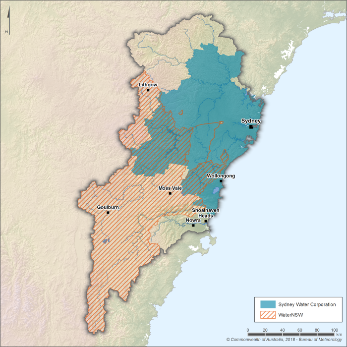
Figure R7 Operational boundaries of the Sydney Water Corporation and WaterNSW within the Sydney region
- WaterNSW is the bulk water supplier for the Sydney region, responsible for managing catchments and storages, including both surface water and groundwater, and transferring water to Sydney Water—the region's major utility—for treatment and distribution to urban and surrounding areas.
- In addition to Sydney Water, WaterNSW also supplies water to other local utilities, including Goulburn Mulwaree Council, Shoalhaven City Council, and Wingecarribee Shire Council, as well as to licenced retail customers within the region.
- Other organisations also access and extract surface water and groundwater under licenced water access entitlements, in accordance with the provisions set out in the relevant water sharing plans.
- Table R1 provides an overview of the key organisations involved in water management across the Sydney region, including their roles and service areas.
| Organisation | Responsibilities | Storages within the region |
| NSW Department of Climate Change, Energy, the Environment and Water |
| n/a |
| Natural Resources Access Regulator |
| n/a |
| WaterNSW |
|
|
| Sydney Water |
| n/a |
| EnergyAustralia |
|
|
| Origin Energy |
| n/a |
| Local Land Services (Greater Sydney and South East) |
| n/a |
| Goulburn Mulwaree Council |
|
|
| Lithgow City Council |
|
|
| Queanbeyan–Palerang Regional Council |
| n/a |
| Shoalhaven City Council |
|
|
| Wingecarribee Shire Council |
|
|
Water rights
")
Operating rules and constraints
- The NSW Department of Climate Change, Energy, the Environment and Water (DCCEEW) manages water entitlements in the Sydney region in accordance with the Water Management Act 2000. Water access licences are registered with NSW Land Registry Services, while DCCEEW oversees the day-to-day operation of these entitlements, including the maintenance of allocation accounts.
- Access licences issued to major water utilities include operational provisions that align with the rules established in the Water Sharing Plan for the Greater Metropolitan Region Unregulated River Water Sources 2023.
- Water restrictions within Sydney Water's area of operation are authorised by the Minister administering the Sydney Water Act 1994, while restrictions in other areas are determined and managed by local urban water utilities. For more information, refer to the Bureau of Meteorology's Water Restrictions website.
- Under the Fish River Water Supply Scheme, allocation volumes are determined by supply agreements between WaterNSW and its customers. When the storage volume in Oberon Reservoir falls below 50%, allocations are restricted. If this occurs at the end of the water year (30 June), entitlement holders are permitted to carry over any unused allocation, up to 20% of their maximum annual entitlement, into the new water year.
- Origin Energy holds an entitlement to operate, at any time, interchanges for hydro-power generation between Lake Yarrunga and Fitzroy Falls Reservoir, and between Bendeela Pondage and Lake Yarrunga. Increases to interchange volumes are subject to conditions related to high electricity demand, power system failure, and flow conditions in Yarrunga Creek.
Water entitlements and other statutory water rights
- Water access licences consist of two components: a share component, which entitles holders to a specified portion of available water, and an extraction component that defines the conditions under which water may be taken. These licences are separate from land ownership and may be issued as continuing or specified purpose licences, the latter of which must be cancelled once the stated purpose ceases.
- Share components are expressed as unit shares for continuing licences or in megalitres for specific purpose licences. The volume of water available for extraction in any given year is set by an available water determination, issued by The NSW Department of Climate Change, Energy, the Environment and Water (DCCEEW).
- Extraction components define the water source location from which water can be taken and may include limits based on the following:
- Timing: When water may be taken — for example, only during certain months or outside of high-risk environmental periods.
- Rate: The speed or flow at which water can be extracted — most commonly expressed in megalitres per day, but may also use hourly rates in litres or megalitres.
- Frequency: How often water may be taken — for example, daily, weekly, or only under certain recurring conditions.
- Circumstances: Specific conditions that must be met for extraction to occur — for example, minimum river flows, environmental triggers, or emergency situations.
- Three basic landholder rights also apply, including:
- Domestic and basic rights
- Native title rights
- Harvestable rights
- For groundwater extraction beyond domestic and stock rights, a licence is required. Licences are managed by WaterNSW for most users, while DCCEEW oversees applications related to large-scale or state significant developments. Compliance with licensing conditions is enforced by the Natural Resources Access Regulator.
Water allocations
- The NSW Department of Climate Change, Energy, the Environment and Water (DCCEEW) oversees the available water determination process for both surface water and groundwater on an annual basis, aligning with the water year from 1 July to 30 June. The volume of water made available for extraction and associated rules, including carryover provisions, are set out in the region's water sharing plans.
- Key elements in available water determination announcements include the water source, licence category, type of announcement, applicable date or period, and volume allocated per share.
- Water sharing priorities are determined by water access licence categories, defined in the following order:
- Environmental needs
- Basic landholder rights, encompassing:
- Domestic and stock rights
- Native title rights
- Harvestable rights
- Licenced rights, including:
- Town water supply
- High security licences
- General security licences
- Other categories as specified
- Entitlement holders are permitted to extract up to their maximum entitlement volume unless restrictions are imposed due to limited water availability, in which case allocations may be capped.
- Basic landholder rights are not subject to specific allocation volumes; however, in periods of limited supply, temporary restrictions may be applied to maintain equitable water supply.
Trades and water rights transfers
- The NSW Department of Climate Change, Energy, the Environment and Water (DCCEEW) is responsible for regulating water trading policies, in accordance with the provisions defined in the Water Management Act 2000. WaterNSW administers the actual trading of water access licences, entitlements, and allocations, ensuring compliance with relevant rules and regulations.
- The interstate transfer of access licences or assignment of water allocations is prohibited for both surface water and groundwater within the Sydney region. These restrictions align with the Water Sharing Plan for the Greater Metropolitan Region Unregulated River Water Sources 2023 and the Water Sharing Plan for the Greater Metropolitan Region Groundwater Sources 2023, which aim to sustainably manage water resources within the region.
- While infrastructure may support physical water transfers between catchments—such as the Shoalhaven and Hawkesbury-Nepean—the mechanisms required for inter-valley water trading are not currently in place. As a result, trading is limited to transactions within individual water sources, as defined in the water sharing plans, and is generally not permitted between different water sources.
- Trading between water sources is restricted to help preserve the sustainability and ecological balance of each water source, as cross-source transfers can disrupt local hydrological regimes. Instead, trading is managed within individual water sources to ensure compliance with plan-specific rules and environmental safeguards.