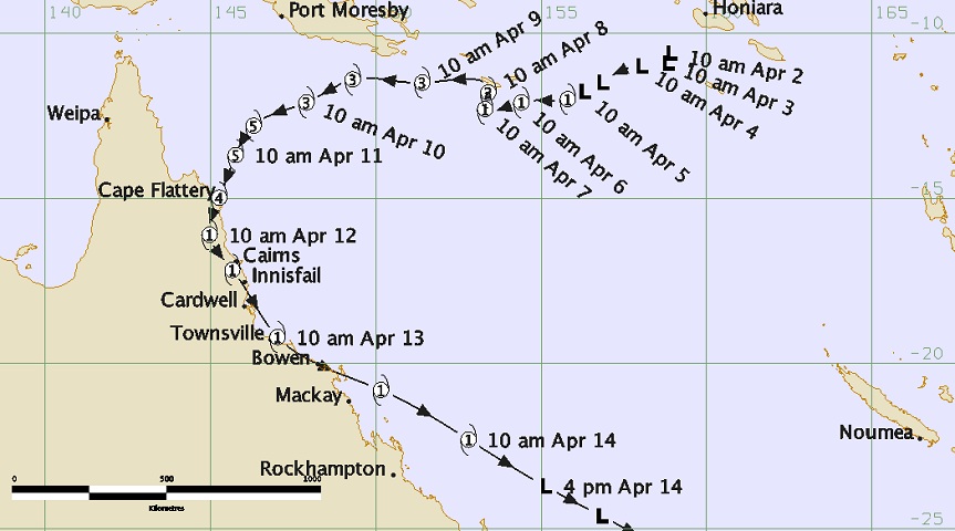
Tropical cyclone Ita began life as a tropical low southwest of the Solomon Islands in the northeastern
Coral Sea on April 2nd, 2014. Over the next few days it drifted westward while slowly intensifying, and was
classified as a category 1 cyclone on the afternoon of April 5th.
|
The cyclone continued to move westward and then stalled south of Sudest Island (Papua New Guinea) for two
days while continuing to intensify, reaching category 3 at 11am on April 8th. It then recommenced its
westward motion, passing south of the Papua New Guinea mainland while maintaining its intensity as a
category 3 cyclone.
|
On the afternoon of April 10, Ita intensified extremely rapidly, reaching category 4 and then category 5
in the span of 6 hours. At the same time it turned southwest towards the far north Queensland coast, where
it made landfall at about 10pm on the evening of Friday April 11th near Cape Flattery. Ita weakened somewhat
in the hours leading up to landfall and at this time has been rated as a category 4 cyclone at landfall,
although this may be revised later once all the data has been reviewed. Cape Flattery automatic weather
station recorded a maximum wind gust of 160 km/h.
|
Near landfall, the centre of Ita came within 5km of the resort at Lizard Island. Unofficial readings
showed the air pressure dropped to approximately 954 hPa and wind gusts reached approximately 155 km/h
before the instrument failed. Considerable vegetation damage but only minor structural damage to buildings
was recorded there.
|
Upon landfall, Ita continued to track southward through the inland North Tropical Coast district. It
weakened reasonably quickly and passed 20km west of Cooktown (the closest population centre to Ita's initial
landfall) as a category 2 cyclone. Wind gusts to approximately 125 km/h were recorded there. 200 buildings
there received (mostly minor) damage, with 16 buildings receiving severe damage or total destruction. A
storm surge of approximately 1.1 metres occurred at about midnight, though fortunately this arrived
coincident with the low astronomical tide and little if any inundation occurred.
|
Ita weakened further to a category 1 cyclone, but was able to maintain this category through the rest of
its two day trek southwards along the north Queensland coast, with much of the time spent over land. Gale
force winds and damaging wind gusts were recorded at Lucinda, Townsville, Cape Ferguson, Mackay, and Middle
Percy Island. The main impact during this phase of Ita's lifetime, though, was rainfall and flooding.
Widespread 24 hour rainfalls of over 300mm, peaking at approximately 400mm, were recorded in the North
Tropical Coast and Herbert and Lower Burdekin districts. The Daintree, Mulgrave, Haughton, and Herbert
Rivers all recorded major floods. Flash flooding occurred at Bowen where 110mm of rainfall in one hour was
recorded.
|
Ita finally turned southeastward and moved off the Queensland coast for good near Proserpine on the night
of April 13th. It maintained category 1 intensity for another 24 hours before transitioning into an extra
tropical low and accelerating southeastward further away from the coast.
|


