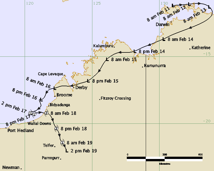
Tropical Cyclone Kelvin, a category 2 system, was the third tropical cyclone to affect the west
Kimberley and east Pilbara regions during the 2017/2018 season. Significant damage was reported at Anna
Plains and Nita Downs stations in the far west Kimberley. Rainfall and associated flooding added to an
already saturated west Kimberley from other recent tropical systems, prolonging road closures over the area.
|
A tropical low was first identified near the northwest coast of the Top End of the Northern Territory on
11 February 2018. It moved east before taking a west southwest track on 13 February over the western Top End
and Joseph Bonaparte Gulf, reaching the north Kimberley by the evening of 14 February. The system slowly
developed as it tracked southwest over land through the northwest Kimberley over the next 24 hours. It moved
out over open waters off the west coast of the Dampier Peninsula on the morning of 16 February and slowly
developed as it moved generally southwest and was named Tropical Cyclone Kelvin at 2pm AWST 17 February,
about 155 kilometres west southwest of Bidyadanga. Kelvin became slow moving during 17 February, before
taking a sharp turn towards the east, intensifying quickly in a favourable environment as it approached the
west Kimberley coast. It made landfall along 80 Mile Beach near Anna Plains Station around 7am AWST 18
February as a category 2 system and was intensifying as it crossed the coast. Kelvin weakened very slowly as
it moved further inland generally towards the south southeast and was downgraded to a tropical low at 2pm
AWST 19 February.
|
Sustained gales were recorded at Broome Port between 11:16 am and 2:11 pm AWST 16 February 2018 as the
system passed to the north of Broome as a low pressure system. Heavy rainfall was recorded over parts of the
northwest Kimberley, far east Pilbara and northwest North Interior districts. 24 hour rainfall totals
included: West Roebuck 370.0 mm to 9am AWST 17 February, Nita Downs 235.0 mm and Wallal Downs 223.5 mm to
9am AWST 18 February. Broome Airport recorded 376.8 mm in the 24 hours to 9am AWST 17 February, contributing
to Broome recording 1506.0 mm for 2018 up to 9am 19 February, which set a new record for its wettest ever
year in 129 years of records. On 18 February Broome Port recorded a 0.5 metre surge and higher than normal
tides were observed at Cable Beach in Broome.
|
Kelvin left a rainfall footprint very similar to numerous other rainfall events this season. Many
catchments were already saturated and had limited ability to absorb water, thus flooding occurred rapidly.
Localised flooding occurred in Kalumburu in the north Kimberley and over the west Kimberley, significant
flooding is likely to have occurred but it is difficult to be definitive as there is limited data and it is
sparsely populated. Widespread road flooding occurred throughout Broome. The Great Northern Highway
sustained significant damage due to the flooding and was closed in parts between Sandfire Roadhouse and
Willare Roadhouse, including into Broome and over the Roebuck Plains.
|
Felled trees, branches stripped of leaves and building damage was reported at Nita Downs and Anna Plains
Station, about 250km southwest of Broome where the system crossed the coast. A person was stranded at Eco
Beach Resort and Broome sustained minor storm related damage.
|
Tropical Cyclone Kelvin was the third tropical cyclone to make landfall in Australia and the fifth
tropical cyclone in the Western Australia area of responsibility for the 2017/2018 tropical cyclone
season.
|
**All information relating to intensity and track is preliminary information based on operational
estimates and subject to change following post analysis. **
|


