Summary
Severe Tropical Cyclone Kelvin, a category 3 system, was the third tropical cyclone to affect the west Kimberley and east Pilbara regions during the 2017/2018 season. Significant damage was reported at Anna Plains and Nita Downs stations in the far west Kimberley. Rainfall and associated flooding added to an already saturated west Kimberley from other recent tropical systems, prolonging road closures over the area.
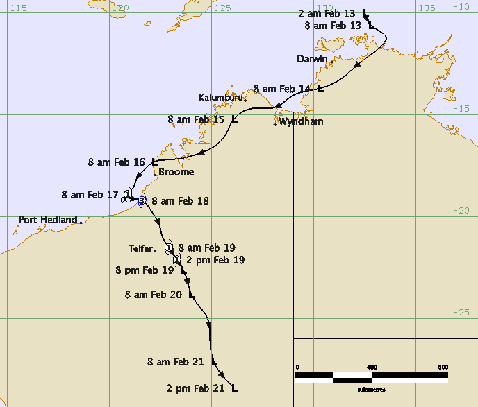
A weak low formed to the northeast of Darwin on 12 February. The low moved southeast and then southwest across western inland parts of the Northern Territory. On 14 February the low tracked west across the Joseph Bonaparte Gulf. The low moved inland across the north Kimberley coast between Wyndham and Kalumburu and continued to move westwards across the north Kimberley.
By 16 February the low was located to the north of Broome. As the low tracked westward and off the Dampier Peninsular gale force winds were recorded at two observing sites located at the Broome Port.
The low continued to move west southwest and developed into a tropical cyclone at 0000 Universal Time Co-ordinated (UTC) 17 February (8 am Australian Western Standard Time (AWST) = UTC + 8 hours). Kelvin became slow moving during the day before taking a sharp eastward turn towards the west Kimberley coast. As Kelvin approached the coast it intensified rapidly. The tropical cyclone made landfall along 80 Mile Beach near Anna Plains Station around 2300 UTC 17 February with a 10-minute maximum peak wind of 80 knots (kn) (150 kilometres per hour (km/h)).
Kelvin maintained its peak intensity for a number of hours after landfall and then weakened only very slowly as it moved further inland, generally towards the south southeast. Kelvin weakened below tropical cyclone strength by 1200 UTC 19 February.
Kelvin was notable not only for its rapid intensification but for also being the third tropical cyclone to affect Broome and the west Kimberley area in three months. Heavy rainfall over the Kimberley during Kelvin, onto an already saturated catchment, contributed to significant flooding.
Localised flooding occurred in Kalumburu in the north Kimberley. Widespread road flooding occurred throughout Broome. The Great Northern Highway sustained significant damage due to the flooding and was closed in parts between Sandfire Roadhouse and Willare Roadhouse, including into Broome and over the Roebuck Plains.
West Roebuck recorded 370.0 mm to 9am AWST 17 February, Nita Downs 235.0 mm and Wallal Downs 223.5 mm to 9am AWST 18 February. Broome Airport recorded 376.8 mm in the 24 hours to 9am AWST 17 February, contributing to Broome recording 1506.0 mm for 2018 up to 9am AWST 19 February, which set a new record for its wettest ever year in 129 years of records.
On 18 February Broome Port recorded a 0.5 metre surge and higher than normal tides were observed at Cable Beach in Broome.
Felled trees, branches stripped of leaves and building damage were reported at Nita Downs and Anna Plains Station, about 250km southwest of Broome where Kelvin crossed the coast. A person was stranded at Eco Beach Resort and Broome sustained minor storm related damage.
For more information see the TC Kelvin Report (pdf).
Track and Intensity